 Note:
The expiration time in the watch graphic is amended if the watch is
replaced, cancelled or extended.
Note:
Note:
The expiration time in the watch graphic is amended if the watch is
replaced, cancelled or extended.
Note: Click for
Watch Status Reports.
SEL8
URGENT - IMMEDIATE BROADCAST REQUESTED
Severe Thunderstorm Watch Number 268
NWS Storm Prediction Center Norman OK
305 PM MDT Sun Jun 13 2021
The NWS Storm Prediction Center has issued a
* Severe Thunderstorm Watch for portions of
Nebraska Panhandle
Southeast Wyoming
* Effective this Sunday afternoon and evening from 305 PM until
1000 PM MDT.
* Primary threats include...
Scattered damaging winds and isolated significant gusts to 75
mph possible
Isolated very large hail events to 2 inches in diameter possible
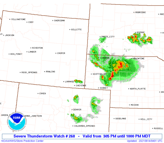
SUMMARY...Initial discrete cells should persist across far southeast
Wyoming, while additional storms form over the northwest Nebraska
Panhandle. This activity should into an east-southeast moving
cluster this evening. Large hail transitioning to predominately
severe wind gusts are the main hazards.
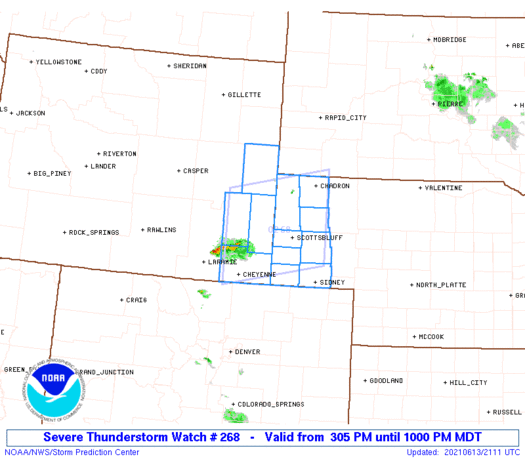
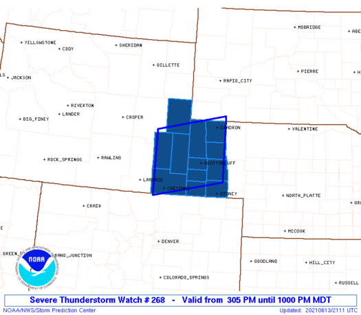
The severe thunderstorm watch area is approximately along and 60
statute miles north and south of a line from 50 miles north
northwest of Cheyenne WY to 15 miles north of Alliance NE. For a
complete depiction of the watch see the associated watch outline
update (WOUS64 KWNS WOU8).
PRECAUTIONARY/PREPAREDNESS ACTIONS...
REMEMBER...A Severe Thunderstorm Watch means conditions are
favorable for severe thunderstorms in and close to the watch area.
Persons in these areas should be on the lookout for threatening
weather conditions and listen for later statements and possible
warnings. Severe thunderstorms can and occasionally do produce
tornadoes.
&&
OTHER WATCH INFORMATION...CONTINUE...WW 264...WW 265...WW
266...WW 267...
AVIATION...A few severe thunderstorms with hail surface and aloft to
2 inches. Extreme turbulence and surface wind gusts to 65 knots. A
few cumulonimbi with maximum tops to 600. Mean storm motion vector
29020.
...Grams
   SEL8

   URGENT - IMMEDIATE BROADCAST REQUESTED
   Severe Thunderstorm Watch Number 268
   NWS Storm Prediction Center Norman OK
   305 PM MDT Sun Jun 13 2021

   The NWS Storm Prediction Center has issued a

   * Severe Thunderstorm Watch for portions of
     Nebraska Panhandle
     Southeast Wyoming

   * Effective this Sunday afternoon and evening from 305 PM until
     1000 PM MDT.

   * Primary threats include...
     Scattered damaging winds and isolated significant gusts to 75
       mph possible
     Isolated very large hail events to 2 inches in diameter possible

   SUMMARY...Initial discrete cells should persist across far southeast
   Wyoming, while additional storms form over the northwest Nebraska
   Panhandle. This activity should into an east-southeast moving
   cluster this evening. Large hail transitioning to predominately
   severe wind gusts are the main hazards.

   The severe thunderstorm watch area is approximately along and 60
   statute miles north and south of a line from 50 miles north
   northwest of Cheyenne WY to 15 miles north of Alliance NE. For a
   complete depiction of the watch see the associated watch outline
   update (WOUS64 KWNS WOU8).

   PRECAUTIONARY/PREPAREDNESS ACTIONS...

   REMEMBER...A Severe Thunderstorm Watch means conditions are
   favorable for severe thunderstorms in and close to the watch area.
   Persons in these areas should be on the lookout for threatening
   weather conditions and listen for later statements and possible
   warnings. Severe thunderstorms can and occasionally do produce
   tornadoes.

   &&

   OTHER WATCH INFORMATION...CONTINUE...WW 264...WW 265...WW
   266...WW 267...

   AVIATION...A few severe thunderstorms with hail surface and aloft to
   2 inches. Extreme turbulence and surface wind gusts to 65 knots. A
   few cumulonimbi with maximum tops to 600. Mean storm motion vector
   29020.

   ...Grams
 Note:
The Aviation Watch (SAW) product is an approximation to the watch area.
The actual watch is depicted by the shaded areas.
Note:
The Aviation Watch (SAW) product is an approximation to the watch area.
The actual watch is depicted by the shaded areas.
   SAW8
   WW 268 SEVERE TSTM NE WY 132105Z - 140400Z
   AXIS..60 STATUTE MILES NORTH AND SOUTH OF LINE..
   50NNW CYS/CHEYENNE WY/ - 15N AIA/ALLIANCE NE/
   ..AVIATION COORDS.. 50NM N/S /38NE LAR - 38NE BFF/
   HAIL SURFACE AND ALOFT..2 INCHES. WIND GUSTS..65 KNOTS.
   MAX TOPS TO 600. MEAN STORM MOTION VECTOR 29020.

   LAT...LON 42690519 43140280 41400280 40950519

   THIS IS AN APPROXIMATION TO THE WATCH AREA.  FOR A
   COMPLETE DEPICTION OF THE WATCH SEE WOUS64 KWNS
   FOR WOU8.
Watch 268 Status Report Messages:
STATUS REPORT #4 ON WW 268

VALID 140130Z - 140240Z

SEVERE WEATHER THREAT CONTINUES RIGHT OF A LINE FROM 30 SSE CYS
TO 20 S TOR TO 55 NW CDR.

FOR ADDITIONAL INFORMATION SEE MESOSCALE DISCUSSION 962

..MOORE..06/14/21

ATTN...WFO...CYS...

&&

STATUS REPORT FOR WS 268

SEVERE WEATHER THREAT CONTINUES FOR THE FOLLOWING AREAS

NEC007-013-033-045-105-123-157-165-140240-

NE
.    NEBRASKA COUNTIES INCLUDED ARE

BANNER		     BOX BUTTE		 CHEYENNE
DAWES		     KIMBALL		 MORRILL
SCOTTS BLUFF	     SIOUX
$$


THE WATCH STATUS MESSAGE IS FOR GUIDANCE PURPOSES ONLY.  PLEASE
REFER TO WATCH COUNTY NOTIFICATION STATEMENTS FOR OFFICIAL
INFORMATION ON COUNTIES...INDEPENDENT CITIES AND MARINE ZONES
CLEARED FROM SEVERE THUNDERSTORM AND TORNADO WATCHES.
$$

STATUS REPORT #3 ON WW 268

VALID 140045Z - 140140Z

SEVERE WEATHER THREAT CONTINUES RIGHT OF A LINE FROM 15 E LAR TO
30 WSW TOR TO 30 NE DGW.

FOR ADDITIONAL INFORMATION SEE MESOSCALE DISCUSSION 962

..MOORE..06/14/21

ATTN...WFO...CYS...

&&

STATUS REPORT FOR WS 268

SEVERE WEATHER THREAT CONTINUES FOR THE FOLLOWING AREAS

NEC007-013-033-045-105-123-157-165-140140-

NE
.    NEBRASKA COUNTIES INCLUDED ARE

BANNER		     BOX BUTTE		 CHEYENNE
DAWES		     KIMBALL		 MORRILL
SCOTTS BLUFF	     SIOUX
$$


WYC015-021-027-140140-

WY
.    WYOMING COUNTIES INCLUDED ARE

GOSHEN		     LARAMIE		 NIOBRARA
$$


THE WATCH STATUS MESSAGE IS FOR GUIDANCE PURPOSES ONLY.  PLEASE
REFER TO WATCH COUNTY NOTIFICATION STATEMENTS FOR OFFICIAL
INFORMATION ON COUNTIES...INDEPENDENT CITIES AND MARINE ZONES
CLEARED FROM SEVERE THUNDERSTORM AND TORNADO WATCHES.
$$

STATUS REPORT #2 ON WW 268

VALID 132345Z - 140040Z

THE SEVERE WEATHER THREAT CONTINUES ACROSS THE ENTIRE WATCH AREA.

..MOORE..06/13/21

ATTN...WFO...CYS...

&&

STATUS REPORT FOR WS 268

SEVERE WEATHER THREAT CONTINUES FOR THE FOLLOWING AREAS

NEC007-013-033-045-105-123-157-165-140040-

NE
.    NEBRASKA COUNTIES INCLUDED ARE

BANNER		     BOX BUTTE		 CHEYENNE
DAWES		     KIMBALL		 MORRILL
SCOTTS BLUFF	     SIOUX
$$


WYC015-021-027-031-140040-

WY
.    WYOMING COUNTIES INCLUDED ARE

GOSHEN		     LARAMIE		 NIOBRARA
PLATTE
$$


THE WATCH STATUS MESSAGE IS FOR GUIDANCE PURPOSES ONLY.  PLEASE
REFER TO WATCH COUNTY NOTIFICATION STATEMENTS FOR OFFICIAL
INFORMATION ON COUNTIES...INDEPENDENT CITIES AND MARINE ZONES
CLEARED FROM SEVERE THUNDERSTORM AND TORNADO WATCHES.
$$

STATUS REPORT #1 ON WW 268

VALID 132225Z - 132340Z

THE SEVERE WEATHER THREAT CONTINUES ACROSS THE ENTIRE WATCH AREA.

..MOORE..06/13/21

ATTN...WFO...CYS...

&&

STATUS REPORT FOR WS 268

SEVERE WEATHER THREAT CONTINUES FOR THE FOLLOWING AREAS

NEC007-013-033-045-105-123-157-165-132340-

NE
.    NEBRASKA COUNTIES INCLUDED ARE

BANNER		     BOX BUTTE		 CHEYENNE
DAWES		     KIMBALL		 MORRILL
SCOTTS BLUFF	     SIOUX
$$


WYC015-021-027-031-132340-

WY
.    WYOMING COUNTIES INCLUDED ARE

GOSHEN		     LARAMIE		 NIOBRARA
PLATTE
$$


THE WATCH STATUS MESSAGE IS FOR GUIDANCE PURPOSES ONLY.  PLEASE
REFER TO WATCH COUNTY NOTIFICATION STATEMENTS FOR OFFICIAL
INFORMATION ON COUNTIES...INDEPENDENT CITIES AND MARINE ZONES
CLEARED FROM SEVERE THUNDERSTORM AND TORNADO WATCHES.
$$
Note:
Click for Complete Product Text.
Tornadoes
Probability of 2 or more tornadoes
|
Low (10%)
|
Probability of 1 or more strong (EF2-EF5) tornadoes
|
Low (<2%)
|
Wind
Probability of 10 or more severe wind events
|
Mod (40%)
|
Probability of 1 or more wind events > 65 knots
|
Mod (30%)
|
Hail
Probability of 10 or more severe hail events
|
Mod (30%)
|
Probability of 1 or more hailstones > 2 inches
|
Mod (30%)
|
Combined Severe Hail/Wind
Probability of 6 or more combined severe hail/wind events
|
High (70%)
|
For each watch, probabilities for particular events inside the watch
(listed above in each table) are determined by the issuing forecaster.
The "Low" category contains probability values ranging from less than 2%
to 20% (EF2-EF5 tornadoes), less than 5% to 20% (all other probabilities),
"Moderate" from 30% to 60%, and "High" from 70% to greater than 95%.
High values are bolded and lighter in color to provide awareness of
an increased threat for a particular event.


 @NWSSPC


