|
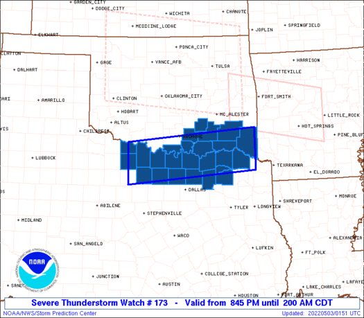
Initial List of Counties in SPC Severe Thunderstorm Watch 173 (WOU)
|
Back to Watch 173
|
 |
   WOUS64 KWNS 030140
   WOU3

   BULLETIN - IMMEDIATE BROADCAST REQUESTED
   SEVERE THUNDERSTORM WATCH OUTLINE UPDATE FOR WS 173
   NWS STORM PREDICTION CENTER NORMAN OK
   845 PM CDT MON MAY 2 2022

   SEVERE THUNDERSTORM WATCH 173 IS IN EFFECT UNTIL 200 AM CDT
   FOR THE FOLLOWING LOCATIONS

   OKC005-013-023-029-069-085-089-095-127-030700-
   /O.NEW.KWNS.SV.A.0173.220503T0145Z-220503T0700Z/

   OK
   .    OKLAHOMA COUNTIES INCLUDED ARE

   ATOKA                BRYAN               CHOCTAW
   COAL                 JOHNSTON            LOVE
   MARSHALL             MCCURTAIN           PUSHMATAHA


   TXC009-077-085-097-119-121-147-181-223-231-237-277-337-387-485-
   497-030700-
   /O.NEW.KWNS.SV.A.0173.220503T0145Z-220503T0700Z/

   TX
   .    TEXAS COUNTIES INCLUDED ARE

   ARCHER               CLAY                COLLIN
   COOKE                DELTA               DENTON
   FANNIN               GRAYSON             HOPKINS
   HUNT                 JACK                LAMAR
   MONTAGUE             RED RIVER           WICHITA
   WISE


   ATTN...WFO...OUN...FWD...SHV...TSA...
|
| Aviation Watch (SAW) for WW173 |
|---|
 |
| Note:
The Aviation Watch (SAW) product is an approximation to the watch area.
The actual watch is depicted by the shaded areas. |
   SAW3
   WW 173 SEVERE TSTM OK TX 030145Z - 030700Z
   AXIS..40 STATUTE MILES NORTH AND SOUTH OF LINE..
   30SSW SPS/WICHITA FALLS TX/ - 55ENE PRX/PARIS TX/
   ..AVIATION COORDS.. 35NM N/S /26SSW SPS - 35NW TXK/
   HAIL SURFACE AND ALOFT..1.5 INCHES. WIND GUSTS..60 KNOTS.
   MAX TOPS TO 500. MEAN STORM MOTION VECTOR 29035.

   LAT...LON 34159870 34509456 33349456 32999870

   THIS IS AN APPROXIMATION TO THE WATCH AREA.  FOR A
   COMPLETE DEPICTION OF THE WATCH SEE WOUS64 KWNS
   FOR WOU3.
|
|


 @NWSSPC
