|
Initial List of Counties in SPC Severe Thunderstorm Watch 205 (WOU)
|
Back to Watch 205
|
 |
WOUS64 KWNS 121716
WOU5
BULLETIN - IMMEDIATE BROADCAST REQUESTED
SEVERE THUNDERSTORM WATCH OUTLINE UPDATE FOR WS 205
NWS STORM PREDICTION CENTER NORMAN OK
1220 PM CDT THU MAY 12 2022
SEVERE THUNDERSTORM WATCH 205 IS IN EFFECT UNTIL 500 PM CDT
FOR THE FOLLOWING LOCATIONS
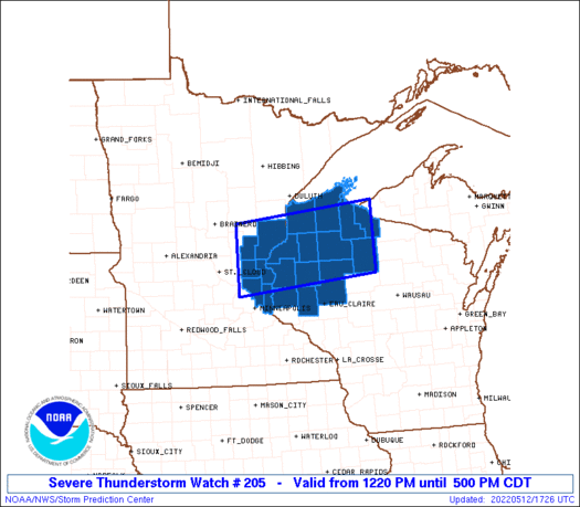
MNC003-025-059-065-115-123-163-122200-
/O.NEW.KWNS.SV.A.0205.220512T1720Z-220512T2200Z/
MN
. MINNESOTA COUNTIES INCLUDED ARE
ANOKA CHISAGO ISANTI
KANABEC PINE RAMSEY
WASHINGTON
WIC003-005-007-013-017-031-033-051-095-099-107-109-113-129-
122200-
/O.NEW.KWNS.SV.A.0205.220512T1720Z-220512T2200Z/
WI
. WISCONSIN COUNTIES INCLUDED ARE
ASHLAND BARRON BAYFIELD
BURNETT CHIPPEWA DOUGLAS
DUNN IRON POLK
PRICE RUSK SAWYER
ST. CROIX WASHBURN
LSZ121-122200-
/O.NEW.KWNS.SV.A.0205.220512T1720Z-220512T2200Z/
CW
. ADJACENT COASTAL WATERS INCLUDED ARE
CHEQUAMEGON BAY-BAYFIELD TO OAK POINT WI
ATTN...WFO...MPX...DLH...
|
| Aviation Watch (SAW) for WW205 |
|---|
 |
| Note:
The Aviation Watch (SAW) product is an approximation to the watch area.
The actual watch is depicted by the shaded areas. |
   SAW5
   WW 205 SEVERE TSTM MN WI LS 121720Z - 122200Z
   AXIS..45 STATUTE MILES NORTH AND SOUTH OF LINE..
   140WSW ASX/KENNEDY WI/ - 35S IWD/IRONWOOD MI/
   ..AVIATION COORDS.. 40NM N/S /41SSE BRD - 37NW RHI/
   HAIL SURFACE AND ALOFT..2 INCHES. WIND GUSTS..60 KNOTS.
   MAX TOPS TO 550. MEAN STORM MOTION VECTOR 26030.

   LAT...LON 46389360 46679013 45379013 45089360

   THIS IS AN APPROXIMATION TO THE WATCH AREA.  FOR A
   COMPLETE DEPICTION OF THE WATCH SEE WOUS64 KWNS
   FOR WOU5.
|
|


 @NWSSPC
