|
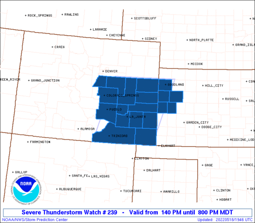
Initial List of Counties in SPC Severe Thunderstorm Watch 239 (WOU)
|
Back to Watch 239
|
 |
   WOUS64 KWNS 181939
   WOU9

   BULLETIN - IMMEDIATE BROADCAST REQUESTED
   SEVERE THUNDERSTORM WATCH OUTLINE UPDATE FOR WS 239
   NWS STORM PREDICTION CENTER NORMAN OK
   140 PM MDT WED MAY 18 2022

   SEVERE THUNDERSTORM WATCH 239 IS IN EFFECT UNTIL 800 PM MDT
   FOR THE FOLLOWING LOCATIONS

   COC009-011-017-025-035-039-041-061-063-071-073-089-099-101-
   190200-
   /O.NEW.KWNS.SV.A.0239.220518T1940Z-220519T0200Z/

   CO
   .    COLORADO COUNTIES INCLUDED ARE

   BACA                 BENT                CHEYENNE
   CROWLEY              DOUGLAS             ELBERT
   EL PASO              KIOWA               KIT CARSON
   LAS ANIMAS           LINCOLN             OTERO
   PROWERS              PUEBLO


   KSC071-109-181-199-203-190200-
   /O.NEW.KWNS.SV.A.0239.220518T1940Z-220519T0200Z/

   KS
   .    KANSAS COUNTIES INCLUDED ARE

   GREELEY              LOGAN               SHERMAN
   WALLACE              WICHITA


   ATTN...WFO...PUB...GLD...BOU...
|
| Aviation Watch (SAW) for WW239 |
|---|
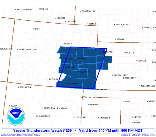 |
| Note:
The Aviation Watch (SAW) product is an approximation to the watch area.
The actual watch is depicted by the shaded areas. |
   SAW9
   WW 239 SEVERE TSTM CO KS 181940Z - 190200Z
   AXIS..80 STATUTE MILES EAST AND WEST OF LINE..
   35NW ITR/BURLINGTON CO/ - 40ESE TAD/TRINIDAD CO/
   ..AVIATION COORDS.. 70NM E/W /39SSE AKO - 14SSW TBE/
   HAIL SURFACE AND ALOFT..1.5 INCHES. WIND GUSTS..65 KNOTS.
   MAX TOPS TO 450. MEAN STORM MOTION VECTOR 31025.

   LAT...LON 39590124 37040221 37040511 39590425

   THIS IS AN APPROXIMATION TO THE WATCH AREA.  FOR A
   COMPLETE DEPICTION OF THE WATCH SEE WOUS64 KWNS
   FOR WOU9.
|
|


 @NWSSPC
