 Note:
The expiration time in the watch graphic is amended if the watch is
replaced, cancelled or extended.
Note:
Note:
The expiration time in the watch graphic is amended if the watch is
replaced, cancelled or extended.
Note: Click for
Watch Status Reports.
SEL2
URGENT - IMMEDIATE BROADCAST REQUESTED
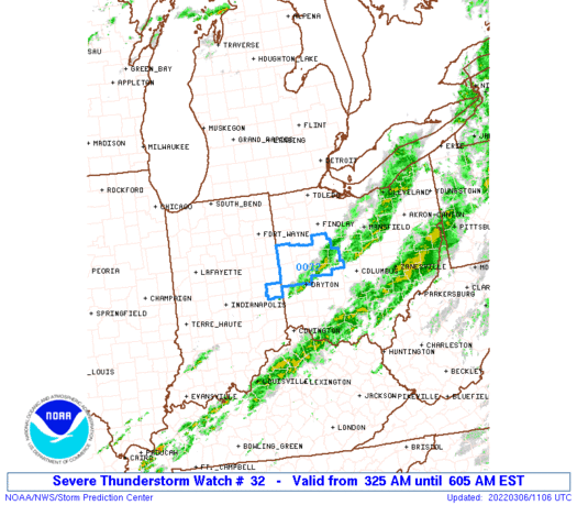
Severe Thunderstorm Watch Number 32
NWS Storm Prediction Center Norman OK
325 AM EST Sun Mar 6 2022
The NWS Storm Prediction Center has issued a
* Severe Thunderstorm Watch for portions of
Far eastern Indiana
Western and Northern Ohio
* Effective this Sunday morning from 325 AM until 700 AM EST.
* Primary threats include...
Isolated damaging wind gusts to 70 mph possible
SUMMARY...A fast-moving line of storms will continue into
western/northern Ohio overnight, with wind damage a distinct
possibility before storms eventually weaken in the predawn hours.
The severe thunderstorm watch area is approximately along and 45
statute miles east and west of a line from 35 miles north of Findlay
OH to 20 miles west southwest of Dayton OH. For a complete depiction
of the watch see the associated watch outline update (WOUS64 KWNS
WOU2).
PRECAUTIONARY/PREPAREDNESS ACTIONS...
REMEMBER...A Severe Thunderstorm Watch means conditions are
favorable for severe thunderstorms in and close to the watch area.
Persons in these areas should be on the lookout for threatening
weather conditions and listen for later statements and possible
warnings. Severe thunderstorms can and occasionally do produce
tornadoes.
&&
OTHER WATCH INFORMATION...CONTINUE...WW 31...
AVIATION...A few severe thunderstorms with hail surface and aloft to
0.5 inches. Extreme turbulence and surface wind gusts to 60 knots. A
few cumulonimbi with maximum tops to 400. Mean storm motion vector
25050.
...Guyer
SEL2
URGENT - IMMEDIATE BROADCAST REQUESTED
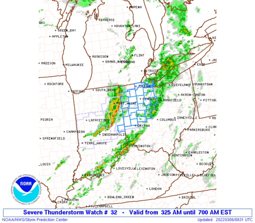
Severe Thunderstorm Watch Number 32
NWS Storm Prediction Center Norman OK
325 AM EST Sun Mar 6 2022
The NWS Storm Prediction Center has issued a
* Severe Thunderstorm Watch for portions of
Far eastern Indiana
Western and Northern Ohio
* Effective this Sunday morning from 325 AM until 700 AM EST.
* Primary threats include...
Isolated damaging wind gusts to 70 mph possible
SUMMARY...A fast-moving line of storms will continue into
western/northern Ohio overnight, with wind damage a distinct
possibility before storms eventually weaken in the predawn hours.
The severe thunderstorm watch area is approximately along and 45
statute miles east and west of a line from 35 miles north of Findlay
OH to 20 miles west southwest of Dayton OH. For a complete depiction
of the watch see the associated watch outline update (WOUS64 KWNS
WOU2).
PRECAUTIONARY/PREPAREDNESS ACTIONS...
REMEMBER...A Severe Thunderstorm Watch means conditions are
favorable for severe thunderstorms in and close to the watch area.
Persons in these areas should be on the lookout for threatening
weather conditions and listen for later statements and possible
warnings. Severe thunderstorms can and occasionally do produce
tornadoes.
&&
OTHER WATCH INFORMATION...CONTINUE...WW 31...
AVIATION...A few severe thunderstorms with hail surface and aloft to
0.5 inches. Extreme turbulence and surface wind gusts to 60 knots. A
few cumulonimbi with maximum tops to 400. Mean storm motion vector
25050.
...Guyer
 Note:
The Aviation Watch (SAW) product is an approximation to the watch area.
The actual watch is depicted by the shaded areas.
Note:
The Aviation Watch (SAW) product is an approximation to the watch area.
The actual watch is depicted by the shaded areas.
SAW2
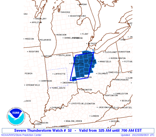
WW 32 SEVERE TSTM IN OH 060825Z - 061200Z
AXIS..45 STATUTE MILES EAST AND WEST OF LINE..
35N FDY/FINDLAY OH/ - 20WSW DAY/DAYTON OH/
..AVIATION COORDS.. 40NM E/W /43SSW DXO - 39SW ROD/
HAIL SURFACE AND ALOFT..0.5 INCH. WIND GUSTS..60 KNOTS.
MAX TOPS TO 400. MEAN STORM MOTION VECTOR 25050.
LAT...LON 41528280 39798372 39798542 41528454
THIS IS AN APPROXIMATION TO THE WATCH AREA. FOR A
COMPLETE DEPICTION OF THE WATCH SEE WOUS64 KWNS
FOR WOU2.
Watch 32 Status Report Message has not been issued yet.
Note:
Click for Complete Product Text.
Tornadoes
Probability of 2 or more tornadoes
|
Low (10%)
|
Probability of 1 or more strong (EF2-EF5) tornadoes
|
Low (5%)
|
Wind
Probability of 10 or more severe wind events
|
Mod (30%)
|
Probability of 1 or more wind events > 65 knots
|
Low (10%)
|
Hail
Probability of 10 or more severe hail events
|
Low (<5%)
|
Probability of 1 or more hailstones > 2 inches
|
Low (<5%)
|
Combined Severe Hail/Wind
Probability of 6 or more combined severe hail/wind events
|
Mod (50%)
|
For each watch, probabilities for particular events inside the watch
(listed above in each table) are determined by the issuing forecaster.
The "Low" category contains probability values ranging from less than 2%
to 20% (EF2-EF5 tornadoes), less than 5% to 20% (all other probabilities),
"Moderate" from 30% to 60%, and "High" from 70% to greater than 95%.
High values are bolded and lighter in color to provide awareness of
an increased threat for a particular event.


 @NWSSPC


