 Note:
The expiration time in the watch graphic is amended if the watch is
replaced, cancelled or extended.
Note:
Note:
The expiration time in the watch graphic is amended if the watch is
replaced, cancelled or extended.
Note: Click for
Watch Status Reports.
SEL5
URGENT - IMMEDIATE BROADCAST REQUESTED
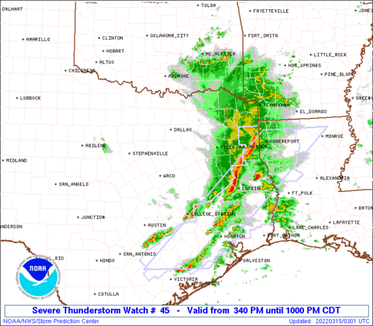
Severe Thunderstorm Watch Number 45
NWS Storm Prediction Center Norman OK
340 PM CDT Mon Mar 14 2022
The NWS Storm Prediction Center has issued a
* Severe Thunderstorm Watch for portions of
Central and East Texas
* Effective this Monday afternoon and evening from 340 PM until
1000 PM CDT.
* Primary threats include...
Scattered damaging winds and isolated significant gusts to 75
mph possible
Scattered large hail and isolated very large hail events to 2.5
inches in diameter possible
A tornado or two possible
SUMMARY...Thunderstorms are expected to develop along and ahead of a
cold front as it moves eastward across central Texas into east
Texas. Enough instability and vertical shear are in place to support
severe thunderstorms capable of large to very large (i.e. diameter
greater than 2" in diameter) hail and strong wind gusts. An isolated
tornado or two is also possible.
The severe thunderstorm watch area is approximately along and 60
statute miles east and west of a line from 30 miles west southwest
of College Station TX to 10 miles east of Paris TX. For a complete
depiction of the watch see the associated watch outline update
(WOUS64 KWNS WOU5).
PRECAUTIONARY/PREPAREDNESS ACTIONS...
REMEMBER...A Severe Thunderstorm Watch means conditions are
favorable for severe thunderstorms in and close to the watch area.
Persons in these areas should be on the lookout for threatening
weather conditions and listen for later statements and possible
warnings. Severe thunderstorms can and occasionally do produce
tornadoes.
&&
AVIATION...A few severe thunderstorms with hail surface and aloft to
2.5 inches. Extreme turbulence and surface wind gusts to 65 knots. A
few cumulonimbi with maximum tops to 450. Mean storm motion vector
24035.
...Mosier
 Note:
The Aviation Watch (SAW) product is an approximation to the watch area.
The actual watch is depicted by the shaded areas.
Note:
The Aviation Watch (SAW) product is an approximation to the watch area.
The actual watch is depicted by the shaded areas.
   SAW5
   WW 45 SEVERE TSTM TX 142040Z - 150300Z
   AXIS..60 STATUTE MILES EAST AND WEST OF LINE..
   30WSW CLL/COLLEGE STATION TX/ - 10E PRX/PARIS TX/
   ..AVIATION COORDS.. 50NM E/W /36E CWK - 61W TXK/
   HAIL SURFACE AND ALOFT..2.5 INCHES. WIND GUSTS..65 KNOTS.
   MAX TOPS TO 450. MEAN STORM MOTION VECTOR 24035.

   LAT...LON 30419784 33639632 33639423 30419583

   THIS IS AN APPROXIMATION TO THE WATCH AREA.  FOR A
   COMPLETE DEPICTION OF THE WATCH SEE WOUS64 KWNS
   FOR WOU5.
Watch 45 Status Report Messages:
STATUS REPORT #5 ON WW 45

VALID 150230Z - 150340Z

SEVERE WEATHER THREAT CONTINUES RIGHT OF A LINE FROM 30 E AUS TO
20 NW CLL TO 45 NNW UTS TO 35 SSW TYR TO 20 ESE TYR TO 20 WNW GGG
TO 20 NNW GGG TO 35 WSW TXK.

FOR ADDITIONAL INFORMATION SEE MESOSCALE DISCUSSION 256

..WENDT..03/15/22

ATTN...WFO...FWD...HGX...SHV...EWX...

&&

STATUS REPORT FOR WS 45

SEVERE WEATHER THREAT CONTINUES FOR THE FOLLOWING AREAS

TXC041-051-073-183-225-287-313-401-150340-

TX
.    TEXAS COUNTIES INCLUDED ARE

BRAZOS		     BURLESON		 CHEROKEE
GREGG		     HOUSTON		 LEE
MADISON 	     RUSK
$$


THE WATCH STATUS MESSAGE IS FOR GUIDANCE PURPOSES ONLY.  PLEASE
REFER TO WATCH COUNTY NOTIFICATION STATEMENTS FOR OFFICIAL
INFORMATION ON COUNTIES...INDEPENDENT CITIES AND MARINE ZONES
CLEARED FROM SEVERE THUNDERSTORM AND TORNADO WATCHES.
$$

STATUS REPORT #4 ON WW 45

VALID 150120Z - 150240Z

SEVERE WEATHER THREAT CONTINUES RIGHT OF A LINE FROM 15 NNW AUS
TO 40 E TPL TO 30 E CRS TO 25 NNW TYR TO 20 S PRX TO 20 NE PRX.

..WENDT..03/15/22

ATTN...WFO...FWD...HGX...SHV...EWX...

&&

STATUS REPORT FOR WS 45

SEVERE WEATHER THREAT CONTINUES FOR THE FOLLOWING AREAS

TXC001-041-051-063-073-159-161-183-213-225-287-289-313-331-343-
387-395-401-423-449-459-491-499-150240-

TX
.    TEXAS COUNTIES INCLUDED ARE

ANDERSON	     BRAZOS		 BURLESON
CAMP		     CHEROKEE		 FRANKLIN
FREESTONE	     GREGG		 HENDERSON
HOUSTON 	     LEE		 LEON
MADISON 	     MILAM		 MORRIS
RED RIVER	     ROBERTSON		 RUSK
SMITH		     TITUS		 UPSHUR
WILLIAMSON	     WOOD
$$


THE WATCH STATUS MESSAGE IS FOR GUIDANCE PURPOSES ONLY.  PLEASE
REFER TO WATCH COUNTY NOTIFICATION STATEMENTS FOR OFFICIAL
INFORMATION ON COUNTIES...INDEPENDENT CITIES AND MARINE ZONES
CLEARED FROM SEVERE THUNDERSTORM AND TORNADO WATCHES.
$$

STATUS REPORT #3 ON WW 45

VALID 150025Z - 150140Z

SEVERE WEATHER THREAT CONTINUES RIGHT OF A LINE FROM 25 NNW AUS
TO 10 ESE TPL TO 25 ESE ACT TO 5 W CRS TO 40 NNE CRS TO 45 SW PRX
TO 20 WNW PRX.

FOR ADDITIONAL INFORMATION SEE MESOSCALE DISCUSSION 255

..WENDT..03/15/22

ATTN...WFO...FWD...HGX...SHV...EWX...

&&

STATUS REPORT FOR WS 45

SEVERE WEATHER THREAT CONTINUES FOR THE FOLLOWING AREAS

TXC001-027-041-051-063-073-119-145-159-161-183-213-223-225-277-
287-289-293-313-331-343-349-379-387-395-401-423-449-459-467-491-
499-150140-

TX
.    TEXAS COUNTIES INCLUDED ARE

ANDERSON	     BELL		 BRAZOS
BURLESON	     CAMP		 CHEROKEE
DELTA		     FALLS		 FRANKLIN
FREESTONE	     GREGG		 HENDERSON
HOPKINS 	     HOUSTON		 LAMAR
LEE		     LEON		 LIMESTONE
MADISON 	     MILAM		 MORRIS
NAVARRO 	     RAINS		 RED RIVER
ROBERTSON	     RUSK		 SMITH
TITUS		     UPSHUR		 VAN ZANDT
WILLIAMSON	     WOOD
$$


THE WATCH STATUS MESSAGE IS FOR GUIDANCE PURPOSES ONLY.  PLEASE
REFER TO WATCH COUNTY NOTIFICATION STATEMENTS FOR OFFICIAL
INFORMATION ON COUNTIES...INDEPENDENT CITIES AND MARINE ZONES
CLEARED FROM SEVERE THUNDERSTORM AND TORNADO WATCHES.
$$

STATUS REPORT #2 ON WW 45

VALID 142340Z - 150040Z

SEVERE WEATHER THREAT CONTINUES RIGHT OF A LINE FROM 15 WSW TPL
TO 10 SSE ACT TO 25 NE ACT TO 30 NNW CRS TO 15 ENE DAL TO 30 SSW
GYI.

..WENDT..03/14/22

ATTN...WFO...FWD...HGX...SHV...EWX...

&&

STATUS REPORT FOR WS 45

SEVERE WEATHER THREAT CONTINUES FOR THE FOLLOWING AREAS

TXC001-027-041-051-063-073-085-119-145-147-159-161-183-213-223-
225-231-257-277-287-289-293-309-313-331-343-349-379-387-395-397-
401-423-449-459-467-491-499-150040-

TX
.    TEXAS COUNTIES INCLUDED ARE

ANDERSON	     BELL		 BRAZOS
BURLESON	     CAMP		 CHEROKEE
COLLIN		     DELTA		 FALLS
FANNIN		     FRANKLIN		 FREESTONE
GREGG		     HENDERSON		 HOPKINS
HOUSTON 	     HUNT		 KAUFMAN
LAMAR		     LEE		 LEON
LIMESTONE	     MCLENNAN		 MADISON
MILAM		     MORRIS		 NAVARRO
RAINS		     RED RIVER		 ROBERTSON
ROCKWALL	     RUSK		 SMITH
TITUS		     UPSHUR		 VAN ZANDT
WILLIAMSON	     WOOD
$$


THE WATCH STATUS MESSAGE IS FOR GUIDANCE PURPOSES ONLY.  PLEASE
REFER TO WATCH COUNTY NOTIFICATION STATEMENTS FOR OFFICIAL
INFORMATION ON COUNTIES...INDEPENDENT CITIES AND MARINE ZONES
CLEARED FROM SEVERE THUNDERSTORM AND TORNADO WATCHES.
$$

STATUS REPORT #1 ON WW 45

VALID 142250Z - 142340Z

THE SEVERE WEATHER THREAT CONTINUES ACROSS THE ENTIRE WATCH AREA.

FOR ADDITIONAL INFORMATION SEE MESOSCALE DISCUSSION 254

..WENDT..03/14/22

ATTN...WFO...FWD...HGX...SHV...EWX...

&&

STATUS REPORT FOR WS 45

SEVERE WEATHER THREAT CONTINUES FOR THE FOLLOWING AREAS

TXC001-027-041-051-063-073-085-113-119-139-145-147-159-161-183-
213-217-223-225-231-257-277-287-289-293-309-313-331-343-349-379-
387-395-397-401-423-449-459-467-491-499-142340-

TX
.    TEXAS COUNTIES INCLUDED ARE

ANDERSON	     BELL		 BRAZOS
BURLESON	     CAMP		 CHEROKEE
COLLIN		     DALLAS		 DELTA
ELLIS		     FALLS		 FANNIN
FRANKLIN	     FREESTONE		 GREGG
HENDERSON	     HILL		 HOPKINS
HOUSTON 	     HUNT		 KAUFMAN
LAMAR		     LEE		 LEON
LIMESTONE	     MCLENNAN		 MADISON
MILAM		     MORRIS		 NAVARRO
RAINS		     RED RIVER		 ROBERTSON
ROCKWALL	     RUSK		 SMITH
TITUS		     UPSHUR		 VAN ZANDT
WILLIAMSON	     WOOD
$$


THE WATCH STATUS MESSAGE IS FOR GUIDANCE PURPOSES ONLY.  PLEASE
REFER TO WATCH COUNTY NOTIFICATION STATEMENTS FOR OFFICIAL
INFORMATION ON COUNTIES...INDEPENDENT CITIES AND MARINE ZONES
CLEARED FROM SEVERE THUNDERSTORM AND TORNADO WATCHES.
$$
Note:
Click for Complete Product Text.
Tornadoes
Probability of 2 or more tornadoes
|
Low (20%)
|
Probability of 1 or more strong (EF2-EF5) tornadoes
|
Low (5%)
|
Wind
Probability of 10 or more severe wind events
|
Mod (40%)
|
Probability of 1 or more wind events > 65 knots
|
Mod (30%)
|
Hail
Probability of 10 or more severe hail events
|
Mod (40%)
|
Probability of 1 or more hailstones > 2 inches
|
Mod (40%)
|
Combined Severe Hail/Wind
Probability of 6 or more combined severe hail/wind events
|
High (70%)
|
For each watch, probabilities for particular events inside the watch
(listed above in each table) are determined by the issuing forecaster.
The "Low" category contains probability values ranging from less than 2%
to 20% (EF2-EF5 tornadoes), less than 5% to 20% (all other probabilities),
"Moderate" from 30% to 60%, and "High" from 70% to greater than 95%.
High values are bolded and lighter in color to provide awareness of
an increased threat for a particular event.


 @NWSSPC


