 Note:
The expiration time in the watch graphic is amended if the watch is
replaced, cancelled or extended.
Note:
Note:
The expiration time in the watch graphic is amended if the watch is
replaced, cancelled or extended.
Note: Click for
Watch Status Reports.
SEL9
URGENT - IMMEDIATE BROADCAST REQUESTED
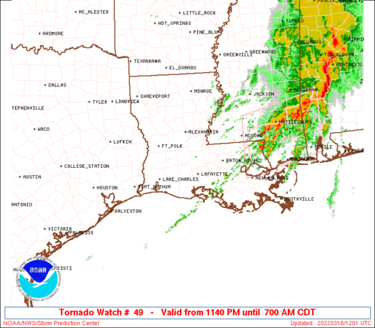
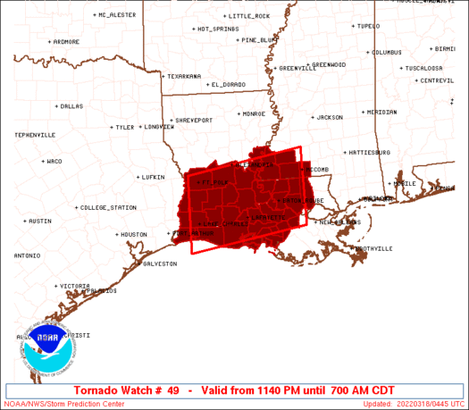
Tornado Watch Number 49
NWS Storm Prediction Center Norman OK
1140 PM CDT Thu Mar 17 2022
The NWS Storm Prediction Center has issued a
* Tornado Watch for portions of
Southern Louisiana
Southwest Mississippi
Coastal Waters
* Effective this Thursday night and Friday morning from 1140 PM
until 700 AM CDT.
* Primary threats include...
Several tornadoes likely with a couple intense tornadoes
possible
Scattered large hail and isolated very large hail events to 2
inches in diameter possible
Scattered damaging wind gusts to 70 mph possible
SUMMARY...Thunderstorms are expected to intensify overnight and
spread across much of southern Louisiana. Strengthening winds aloft
and increasing moisture will pose a risk of supercell storms capable
of tornadoes. A strong tornado or two is possible.
The tornado watch area is approximately along and 60 statute miles
north and south of a line from 20 miles northwest of Lake Charles LA
to 25 miles south of Mc Comb MS. For a complete depiction of the
watch see the associated watch outline update (WOUS64 KWNS WOU9).
PRECAUTIONARY/PREPAREDNESS ACTIONS...
REMEMBER...A Tornado Watch means conditions are favorable for
tornadoes and severe thunderstorms in and close to the watch
area. Persons in these areas should be on the lookout for
threatening weather conditions and listen for later statements
and possible warnings.
&&
AVIATION...Tornadoes and a few severe thunderstorms with hail
surface and aloft to 2 inches. Extreme turbulence and surface wind
gusts to 60 knots. A few cumulonimbi with maximum tops to 500. Mean
storm motion vector 22035.
...Hart
 Note:
The Aviation Watch (SAW) product is an approximation to the watch area.
The actual watch is depicted by the shaded areas.
Note:
The Aviation Watch (SAW) product is an approximation to the watch area.
The actual watch is depicted by the shaded areas.
   SAW9
   WW 49 TORNADO LA MS CW 180440Z - 181200Z
   AXIS..60 STATUTE MILES NORTH AND SOUTH OF LINE..
   20NW LCH/LAKE CHARLES LA/ - 25S MCB/MC COMB MS/
   ..AVIATION COORDS.. 50NM N/S /21WNW LCH - 31SSW MCB/
   HAIL SURFACE AND ALOFT..2 INCHES. WIND GUSTS..60 KNOTS.
   MAX TOPS TO 500. MEAN STORM MOTION VECTOR 22035.

   LAT...LON 31209346 31699047 29959047 29479346

   THIS IS AN APPROXIMATION TO THE WATCH AREA.  FOR A
   COMPLETE DEPICTION OF THE WATCH SEE WOUS64 KWNS
   FOR WOU9.
Watch 49 Status Report Messages:
STATUS REPORT #6 ON WW 49

VALID 181030Z - 181140Z

SEVERE WEATHER THREAT CONTINUES RIGHT OF A LINE FROM 20 N HUM TO
45 NW HUM TO 35 SW MCB TO 10 ENE MCB.

..GLEASON..03/18/22

ATTN...WFO...LCH...LIX...JAN...

&&

STATUS REPORT FOR WT 49

SEVERE WEATHER THREAT CONTINUES FOR THE FOLLOWING AREAS

LAC005-063-091-093-105-181140-

LA
.    LOUISIANA PARISHES INCLUDED ARE

ASCENSION	     LIVINGSTON 	 ST. HELENA
ST. JAMES	     TANGIPAHOA
$$


MSC113-181140-

MS
.    MISSISSIPPI COUNTIES INCLUDED ARE

PIKE
$$


THE WATCH STATUS MESSAGE IS FOR GUIDANCE PURPOSES ONLY.  PLEASE
REFER TO WATCH COUNTY NOTIFICATION STATEMENTS FOR OFFICIAL
INFORMATION ON COUNTIES...INDEPENDENT CITIES AND MARINE ZONES
CLEARED FROM SEVERE THUNDERSTORM AND TORNADO WATCHES.
$$

STATUS REPORT #5 ON WW 49

VALID 180925Z - 181040Z

SEVERE WEATHER THREAT CONTINUES RIGHT OF A LINE FROM 20 WNW HUM
TO 30 E LFT TO 40 NNE LFT TO 20 E HEZ.

..GLEASON..03/18/22

ATTN...WFO...LCH...LIX...JAN...

&&

STATUS REPORT FOR WT 49

SEVERE WEATHER THREAT CONTINUES FOR THE FOLLOWING AREAS

LAC005-007-033-037-047-063-077-091-093-105-121-125-181040-

LA
.    LOUISIANA PARISHES INCLUDED ARE

ASCENSION	     ASSUMPTION 	 EAST BATON ROUGE
EAST FELICIANA	     IBERVILLE		 LIVINGSTON
POINTE COUPEE	     ST. HELENA 	 ST. JAMES
TANGIPAHOA	     WEST BATON ROUGE	 WEST FELICIANA
$$


MSC005-037-113-157-181040-

MS
.    MISSISSIPPI COUNTIES INCLUDED ARE

AMITE		     FRANKLIN		 PIKE
WILKINSON
$$


THE WATCH STATUS MESSAGE IS FOR GUIDANCE PURPOSES ONLY.  PLEASE
REFER TO WATCH COUNTY NOTIFICATION STATEMENTS FOR OFFICIAL
INFORMATION ON COUNTIES...INDEPENDENT CITIES AND MARINE ZONES
CLEARED FROM SEVERE THUNDERSTORM AND TORNADO WATCHES.
$$

STATUS REPORT #4 ON WW 49

VALID 180840Z - 180940Z

SEVERE WEATHER THREAT CONTINUES RIGHT OF A LINE FROM 45 ESE 7R4
TO 15 ENE 7R4 TO 35 N LFT TO 30 ESE ESF TO 5 N HEZ.

FOR ADDITIONAL INFORMATION SEE MESOSCALE DISCUSSION 274

..GLEASON..03/18/22

ATTN...WFO...LCH...LIX...JAN...

&&

STATUS REPORT FOR WT 49

SEVERE WEATHER THREAT CONTINUES FOR THE FOLLOWING AREAS

LAC005-007-009-029-033-037-045-047-055-063-077-091-093-097-099-
101-105-121-125-180940-

LA
.    LOUISIANA PARISHES INCLUDED ARE

ASCENSION	     ASSUMPTION 	 AVOYELLES
CONCORDIA	     EAST BATON ROUGE	 EAST FELICIANA
IBERIA		     IBERVILLE		 LAFAYETTE
LIVINGSTON	     POINTE COUPEE	 ST. HELENA
ST. JAMES	     ST. LANDRY 	 ST. MARTIN
ST. MARY	     TANGIPAHOA 	 WEST BATON ROUGE
WEST FELICIANA
$$


MSC001-005-037-113-157-180940-

MS
.    MISSISSIPPI COUNTIES INCLUDED ARE

ADAMS		     AMITE		 FRANKLIN
PIKE		     WILKINSON
$$


THE WATCH STATUS MESSAGE IS FOR GUIDANCE PURPOSES ONLY.  PLEASE
REFER TO WATCH COUNTY NOTIFICATION STATEMENTS FOR OFFICIAL
INFORMATION ON COUNTIES...INDEPENDENT CITIES AND MARINE ZONES
CLEARED FROM SEVERE THUNDERSTORM AND TORNADO WATCHES.
$$

STATUS REPORT #3 ON WW 49

VALID 180740Z - 180840Z

SEVERE WEATHER THREAT CONTINUES RIGHT OF A LINE FROM 35 SW 7R4 TO
35 S ESF TO 20 ENE ESF.

..GLEASON..03/18/22

ATTN...WFO...LCH...LIX...JAN...

&&

STATUS REPORT FOR WT 49

SEVERE WEATHER THREAT CONTINUES FOR THE FOLLOWING AREAS

LAC001-005-007-009-029-033-037-039-045-047-055-063-077-091-093-
097-099-101-105-113-121-125-180840-

LA
.    LOUISIANA PARISHES INCLUDED ARE

ACADIA		     ASCENSION		 ASSUMPTION
AVOYELLES	     CONCORDIA		 EAST BATON ROUGE
EAST FELICIANA	     EVANGELINE 	 IBERIA
IBERVILLE	     LAFAYETTE		 LIVINGSTON
POINTE COUPEE	     ST. HELENA 	 ST. JAMES
ST. LANDRY	     ST. MARTIN 	 ST. MARY
TANGIPAHOA	     VERMILION		 WEST BATON ROUGE
WEST FELICIANA
$$


MSC001-005-037-113-157-180840-

MS
.    MISSISSIPPI COUNTIES INCLUDED ARE

ADAMS		     AMITE		 FRANKLIN
PIKE		     WILKINSON
$$


GMZ435-180840-

CW

.    ADJACENT COASTAL WATERS INCLUDED ARE

VERMILION BAY

$$
THE WATCH STATUS MESSAGE IS FOR GUIDANCE PURPOSES ONLY.  PLEASE
REFER TO WATCH COUNTY NOTIFICATION STATEMENTS FOR OFFICIAL
INFORMATION ON COUNTIES...INDEPENDENT CITIES AND MARINE ZONES
CLEARED FROM SEVERE THUNDERSTORM AND TORNADO WATCHES.
$$

STATUS REPORT #2 ON WW 49

VALID 180645Z - 180740Z

SEVERE WEATHER THREAT CONTINUES RIGHT OF A LINE FROM 45 S LCH TO
35 NE LCH TO 10 N ESF.

FOR ADDITIONAL INFORMATION SEE MESOSCALE DISCUSSION 273

..GLEASON..03/18/22

ATTN...WFO...LCH...LIX...JAN...

&&

STATUS REPORT FOR WT 49

SEVERE WEATHER THREAT CONTINUES FOR THE FOLLOWING AREAS

LAC001-003-005-007-009-023-029-033-037-039-045-047-053-055-063-
077-079-091-093-097-099-101-105-113-121-125-180740-

LA
.    LOUISIANA PARISHES INCLUDED ARE

ACADIA		     ALLEN		 ASCENSION
ASSUMPTION	     AVOYELLES		 CAMERON
CONCORDIA	     EAST BATON ROUGE	 EAST FELICIANA
EVANGELINE	     IBERIA		 IBERVILLE
JEFFERSON DAVIS      LAFAYETTE		 LIVINGSTON
POINTE COUPEE	     RAPIDES		 ST. HELENA
ST. JAMES	     ST. LANDRY 	 ST. MARTIN
ST. MARY	     TANGIPAHOA 	 VERMILION
WEST BATON ROUGE     WEST FELICIANA
$$


MSC001-005-037-113-157-180740-

MS
.    MISSISSIPPI COUNTIES INCLUDED ARE

ADAMS		     AMITE		 FRANKLIN
PIKE		     WILKINSON
$$


GMZ435-180740-

CW

.    ADJACENT COASTAL WATERS INCLUDED ARE

VERMILION BAY

$$
THE WATCH STATUS MESSAGE IS FOR GUIDANCE PURPOSES ONLY.  PLEASE
REFER TO WATCH COUNTY NOTIFICATION STATEMENTS FOR OFFICIAL
INFORMATION ON COUNTIES...INDEPENDENT CITIES AND MARINE ZONES
CLEARED FROM SEVERE THUNDERSTORM AND TORNADO WATCHES.
$$

STATUS REPORT #1 ON WW 49

VALID 180535Z - 180640Z

THE SEVERE WEATHER THREAT CONTINUES ACROSS THE ENTIRE WATCH AREA.

..GLEASON..03/18/22

ATTN...WFO...LCH...LIX...JAN...

&&

STATUS REPORT FOR WT 49

SEVERE WEATHER THREAT CONTINUES FOR THE FOLLOWING AREAS

LAC001-003-005-007-009-011-019-023-029-033-037-039-045-047-053-
055-063-077-079-091-093-097-099-101-105-113-115-121-125-
180640-

LA
.    LOUISIANA PARISHES INCLUDED ARE

ACADIA		     ALLEN		 ASCENSION
ASSUMPTION	     AVOYELLES		 BEAUREGARD
CALCASIEU	     CAMERON		 CONCORDIA
EAST BATON ROUGE     EAST FELICIANA	 EVANGELINE
IBERIA		     IBERVILLE		 JEFFERSON DAVIS
LAFAYETTE	     LIVINGSTON 	 POINTE COUPEE
RAPIDES 	     ST. HELENA 	 ST. JAMES
ST. LANDRY	     ST. MARTIN 	 ST. MARY
TANGIPAHOA	     VERMILION		 VERNON
WEST BATON ROUGE     WEST FELICIANA
$$


MSC001-005-037-113-157-180640-

MS
.    MISSISSIPPI COUNTIES INCLUDED ARE

ADAMS		     AMITE		 FRANKLIN
PIKE		     WILKINSON
$$


GMZ432-435-180640-

CW

.    ADJACENT COASTAL WATERS INCLUDED ARE

CALCASIEU LAKE

VERMILION BAY

$$
THE WATCH STATUS MESSAGE IS FOR GUIDANCE PURPOSES ONLY.  PLEASE
REFER TO WATCH COUNTY NOTIFICATION STATEMENTS FOR OFFICIAL
INFORMATION ON COUNTIES...INDEPENDENT CITIES AND MARINE ZONES
CLEARED FROM SEVERE THUNDERSTORM AND TORNADO WATCHES.
$$
Note:
Click for Complete Product Text.
Tornadoes
Probability of 2 or more tornadoes
|
High (80%)
|
Probability of 1 or more strong (EF2-EF5) tornadoes
|
Mod (50%)
|
Wind
Probability of 10 or more severe wind events
|
Mod (50%)
|
Probability of 1 or more wind events > 65 knots
|
Low (20%)
|
Hail
Probability of 10 or more severe hail events
|
Mod (40%)
|
Probability of 1 or more hailstones > 2 inches
|
Mod (30%)
|
Combined Severe Hail/Wind
Probability of 6 or more combined severe hail/wind events
|
High (80%)
|
For each watch, probabilities for particular events inside the watch
(listed above in each table) are determined by the issuing forecaster.
The "Low" category contains probability values ranging from less than 2%
to 20% (EF2-EF5 tornadoes), less than 5% to 20% (all other probabilities),
"Moderate" from 30% to 60%, and "High" from 70% to greater than 95%.
High values are bolded and lighter in color to provide awareness of
an increased threat for a particular event.


 @NWSSPC


