 Note:
The expiration time in the watch graphic is amended if the watch is
replaced, cancelled or extended.
Note:
Note:
The expiration time in the watch graphic is amended if the watch is
replaced, cancelled or extended.
Note: Click for
Watch Status Reports.
SEL6
URGENT - IMMEDIATE BROADCAST REQUESTED
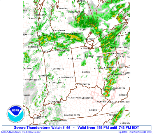
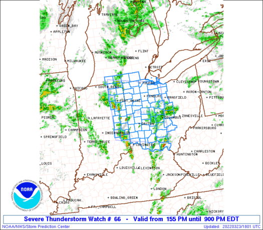
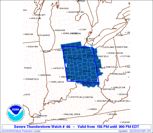
Severe Thunderstorm Watch Number 66
NWS Storm Prediction Center Norman OK
155 PM EDT Wed Mar 23 2022
The NWS Storm Prediction Center has issued a
* Severe Thunderstorm Watch for portions of
Eastern Indiana
Southern Lower Michigan
Western and Central Ohio
* Effective this Wednesday afternoon and evening from 155 PM
until 900 PM EDT.
* Primary threats include...
Scattered large hail events to 1 inch in diameter possible
Isolated damaging wind gusts to 65 mph possible
A tornado or two possible
SUMMARY...Arcing bands of storms, which may included some embedded
low-topped supercells, are expected to further develop and intensify
and move generally northeastward across the region through the
afternoon. Isolated severe hail and locally damaging winds are
expected to be the primary hazards, but a brief tornado or two could
also occur.
The severe thunderstorm watch area is approximately along and 90
statute miles north and south of a line from 30 miles north
northwest of Muncie IN to 15 miles northeast of Columbus OH. For a
complete depiction of the watch see the associated watch outline
update (WOUS64 KWNS WOU6).
PRECAUTIONARY/PREPAREDNESS ACTIONS...
REMEMBER...A Severe Thunderstorm Watch means conditions are
favorable for severe thunderstorms in and close to the watch area.
Persons in these areas should be on the lookout for threatening
weather conditions and listen for later statements and possible
warnings. Severe thunderstorms can and occasionally do produce
tornadoes.
&&
AVIATION...A few severe thunderstorms with hail surface and aloft to
1 inch. Extreme turbulence and surface wind gusts to 55 knots. A few
cumulonimbi with maximum tops to 450. Mean storm motion vector
23035.
...Guyer
   SEL6

   URGENT - IMMEDIATE BROADCAST REQUESTED
   Severe Thunderstorm Watch Number 66
   NWS Storm Prediction Center Norman OK
   155 PM EDT Wed Mar 23 2022

   The NWS Storm Prediction Center has issued a

   * Severe Thunderstorm Watch for portions of
     Eastern Indiana
     Southern Lower Michigan
     Western and Central Ohio

   * Effective this Wednesday afternoon and evening from 155 PM
     until 900 PM EDT.

   * Primary threats include...
     Scattered large hail events to 1 inch in diameter possible
     Isolated damaging wind gusts to 65 mph possible
     A tornado or two possible

   SUMMARY...Arcing bands of storms, which may included some embedded
   low-topped supercells, are expected to further develop and intensify
   and move generally northeastward across the region through the
   afternoon. Isolated severe hail and locally damaging winds are
   expected to be the primary hazards, but a brief tornado or two could
   also occur.

   The severe thunderstorm watch area is approximately along and 90
   statute miles north and south of a line from 30 miles north
   northwest of Muncie IN to 15 miles northeast of Columbus OH. For a
   complete depiction of the watch see the associated watch outline
   update (WOUS64 KWNS WOU6).

   PRECAUTIONARY/PREPAREDNESS ACTIONS...

   REMEMBER...A Severe Thunderstorm Watch means conditions are
   favorable for severe thunderstorms in and close to the watch area.
   Persons in these areas should be on the lookout for threatening
   weather conditions and listen for later statements and possible
   warnings. Severe thunderstorms can and occasionally do produce
   tornadoes.

   &&

   AVIATION...A few severe thunderstorms with hail surface and aloft to
   1 inch. Extreme turbulence and surface wind gusts to 55 knots. A few
   cumulonimbi with maximum tops to 450. Mean storm motion vector
   23035.

   ...Guyer
 Note:
The Aviation Watch (SAW) product is an approximation to the watch area.
The actual watch is depicted by the shaded areas.
Note:
The Aviation Watch (SAW) product is an approximation to the watch area.
The actual watch is depicted by the shaded areas.
   SAW6
   WW 66 SEVERE TSTM IN MI OH 231755Z - 240100Z
   AXIS..90 STATUTE MILES NORTH AND SOUTH OF LINE..
   30NNW MIE/MUNCIE IN/ - 15NE CMH/COLUMBUS OH/
   ..AVIATION COORDS.. 80NM N/S /28SW FWA - 4W APE/
   HAIL SURFACE AND ALOFT..1 INCH. WIND GUSTS..55 KNOTS.
   MAX TOPS TO 450. MEAN STORM MOTION VECTOR 23035.

   LAT...LON 41958562 41468268 38848268 39348562

   THIS IS AN APPROXIMATION TO THE WATCH AREA.  FOR A
   COMPLETE DEPICTION OF THE WATCH SEE WOUS64 KWNS
   FOR WOU6.
Watch 66 Status Report Messages:
STATUS REPORT #4 ON WW 66

VALID 232320Z - 240100Z

SEVERE WEATHER THREAT CONTINUES RIGHT OF A LINE FROM LUK TO 30
NNE DAY TO 25 SW FDY TO 10 NNW MFD.

WW 66 WILL BE ALLOWED TO EXPIRE AT 240100Z.

..SQUITIERI..03/23/22

ATTN...WFO...IWX...IND...ILN...DTX...CLE...

&&

STATUS REPORT FOR WS 66

SEVERE WEATHER THREAT CONTINUES FOR THE FOLLOWING AREAS

OHC021-023-033-041-045-047-049-065-073-083-089-091-097-101-117-
129-131-139-141-145-159-175-240100-

OH
.    OHIO COUNTIES INCLUDED ARE

CHAMPAIGN	     CLARK		 CRAWFORD
DELAWARE	     FAIRFIELD		 FAYETTE
FRANKLIN	     HARDIN		 HOCKING
KNOX		     LICKING		 LOGAN
MADISON 	     MARION		 MORROW
PICKAWAY	     PIKE		 RICHLAND
ROSS		     SCIOTO		 UNION
WYANDOT
$$


THE WATCH STATUS MESSAGE IS FOR GUIDANCE PURPOSES ONLY.  PLEASE
REFER TO WATCH COUNTY NOTIFICATION STATEMENTS FOR OFFICIAL
INFORMATION ON COUNTIES...INDEPENDENT CITIES AND MARINE ZONES
CLEARED FROM SEVERE THUNDERSTORM AND TORNADO WATCHES.
$$

STATUS REPORT #3 ON WW 66

VALID 232220Z - 232340Z

SEVERE WEATHER THREAT CONTINUES RIGHT OF A LINE FROM 5 SW LUK TO
25 NNE DAY TO 25 SE JXN.

..SQUITIERI..03/23/22

ATTN...WFO...IWX...IND...ILN...DTX...CLE...

&&

STATUS REPORT FOR WS 66

SEVERE WEATHER THREAT CONTINUES FOR THE FOLLOWING AREAS

MIC091-232340-

MI
.    MICHIGAN COUNTIES INCLUDED ARE

LENAWEE
$$


OHC001-015-021-023-025-027-033-041-043-045-047-049-051-057-063-
065-069-071-073-077-083-089-091-095-097-101-117-123-129-131-139-
141-143-145-147-159-165-173-175-232340-

OH
.    OHIO COUNTIES INCLUDED ARE

ADAMS		     BROWN		 CHAMPAIGN
CLARK		     CLERMONT		 CLINTON
CRAWFORD	     DELAWARE		 ERIE
FAIRFIELD	     FAYETTE		 FRANKLIN
FULTON		     GREENE		 HANCOCK
HARDIN		     HENRY		 HIGHLAND
HOCKING 	     HURON		 KNOX
LICKING 	     LOGAN		 LUCAS
MADISON 	     MARION		 MORROW
OTTAWA		     PICKAWAY		 PIKE
RICHLAND	     ROSS		 SANDUSKY
SCIOTO		     SENECA		 UNION
WARREN		     WOOD		 WYANDOT
$$


THE WATCH STATUS MESSAGE IS FOR GUIDANCE PURPOSES ONLY.  PLEASE
REFER TO WATCH COUNTY NOTIFICATION STATEMENTS FOR OFFICIAL
INFORMATION ON COUNTIES...INDEPENDENT CITIES AND MARINE ZONES
CLEARED FROM SEVERE THUNDERSTORM AND TORNADO WATCHES.
$$

STATUS REPORT #2 ON WW 66

VALID 232045Z - 232140Z

THE SEVERE WEATHER THREAT CONTINUES ACROSS THE ENTIRE WATCH AREA.

FOR ADDITIONAL INFORMATION SEE MESOSCALE DISCUSSION 327

..WENDT..03/23/22

ATTN...WFO...IWX...IND...ILN...DTX...CLE...

&&

STATUS REPORT FOR WS 66

SEVERE WEATHER THREAT CONTINUES FOR THE FOLLOWING AREAS

INC001-003-009-033-035-041-047-065-069-075-087-113-135-139-151-
161-177-179-183-232140-

IN
.    INDIANA COUNTIES INCLUDED ARE

ADAMS		     ALLEN		 BLACKFORD
DE KALB 	     DELAWARE		 FAYETTE
FRANKLIN	     HENRY		 HUNTINGTON
JAY		     LAGRANGE		 NOBLE
RANDOLPH	     RUSH		 STEUBEN
UNION		     WAYNE		 WELLS
WHITLEY
$$


MIC023-059-091-149-232140-

MI
.    MICHIGAN COUNTIES INCLUDED ARE

BRANCH		     HILLSDALE		 LENAWEE
ST. JOSEPH
$$


OHC001-003-011-015-017-021-023-025-027-033-037-039-041-043-045-
047-049-051-057-061-063-065-069-071-073-077-083-089-091-095-097-
101-107-109-113-117-123-125-129-131-135-137-139-141-143-145-147-
149-159-161-165-171-173-175-232140-

OH
.    OHIO COUNTIES INCLUDED ARE

ADAMS		     ALLEN		 AUGLAIZE
BROWN		     BUTLER		 CHAMPAIGN
CLARK		     CLERMONT		 CLINTON
CRAWFORD	     DARKE		 DEFIANCE
DELAWARE	     ERIE		 FAIRFIELD
FAYETTE 	     FRANKLIN		 FULTON
GREENE		     HAMILTON		 HANCOCK
HARDIN		     HENRY		 HIGHLAND
HOCKING 	     HURON		 KNOX
LICKING 	     LOGAN		 LUCAS
MADISON 	     MARION		 MERCER
MIAMI		     MONTGOMERY 	 MORROW
OTTAWA		     PAULDING		 PICKAWAY
PIKE		     PREBLE		 PUTNAM
RICHLAND	     ROSS		 SANDUSKY
SCIOTO		     SENECA		 SHELBY
UNION		     VAN WERT		 WARREN
WILLIAMS	     WOOD		 WYANDOT
$$


THE WATCH STATUS MESSAGE IS FOR GUIDANCE PURPOSES ONLY.  PLEASE
REFER TO WATCH COUNTY NOTIFICATION STATEMENTS FOR OFFICIAL
INFORMATION ON COUNTIES...INDEPENDENT CITIES AND MARINE ZONES
CLEARED FROM SEVERE THUNDERSTORM AND TORNADO WATCHES.
$$

STATUS REPORT #1 ON WW 66

VALID 231930Z - 232040Z

THE SEVERE WEATHER THREAT CONTINUES ACROSS THE ENTIRE WATCH AREA.

..WENDT..03/23/22

ATTN...WFO...IWX...IND...ILN...DTX...CLE...

&&

STATUS REPORT FOR WS 66

SEVERE WEATHER THREAT CONTINUES FOR THE FOLLOWING AREAS

INC001-003-009-033-035-041-047-065-069-075-087-113-135-139-151-
161-177-179-183-232040-

IN
.    INDIANA COUNTIES INCLUDED ARE

ADAMS		     ALLEN		 BLACKFORD
DE KALB 	     DELAWARE		 FAYETTE
FRANKLIN	     HENRY		 HUNTINGTON
JAY		     LAGRANGE		 NOBLE
RANDOLPH	     RUSH		 STEUBEN
UNION		     WAYNE		 WELLS
WHITLEY
$$


MIC023-059-091-149-232040-

MI
.    MICHIGAN COUNTIES INCLUDED ARE

BRANCH		     HILLSDALE		 LENAWEE
ST. JOSEPH
$$


OHC001-003-011-015-017-021-023-025-027-033-037-039-041-043-045-
047-049-051-057-061-063-065-069-071-073-077-083-089-091-095-097-
101-107-109-113-117-123-125-129-131-135-137-139-141-143-145-147-
149-159-161-165-171-173-175-232040-

OH
.    OHIO COUNTIES INCLUDED ARE

ADAMS		     ALLEN		 AUGLAIZE
BROWN		     BUTLER		 CHAMPAIGN
CLARK		     CLERMONT		 CLINTON
CRAWFORD	     DARKE		 DEFIANCE
DELAWARE	     ERIE		 FAIRFIELD
FAYETTE 	     FRANKLIN		 FULTON
GREENE		     HAMILTON		 HANCOCK
HARDIN		     HENRY		 HIGHLAND
HOCKING 	     HURON		 KNOX
LICKING 	     LOGAN		 LUCAS
MADISON 	     MARION		 MERCER
MIAMI		     MONTGOMERY 	 MORROW
OTTAWA		     PAULDING		 PICKAWAY
PIKE		     PREBLE		 PUTNAM
RICHLAND	     ROSS		 SANDUSKY
SCIOTO		     SENECA		 SHELBY
UNION		     VAN WERT		 WARREN
WILLIAMS	     WOOD		 WYANDOT
$$


THE WATCH STATUS MESSAGE IS FOR GUIDANCE PURPOSES ONLY.  PLEASE
REFER TO WATCH COUNTY NOTIFICATION STATEMENTS FOR OFFICIAL
INFORMATION ON COUNTIES...INDEPENDENT CITIES AND MARINE ZONES
CLEARED FROM SEVERE THUNDERSTORM AND TORNADO WATCHES.
$$
Note:
Click for Complete Product Text.
Tornadoes
Probability of 2 or more tornadoes
|
Low (20%)
|
Probability of 1 or more strong (EF2-EF5) tornadoes
|
Low (10%)
|
Wind
Probability of 10 or more severe wind events
|
Mod (30%)
|
Probability of 1 or more wind events > 65 knots
|
Low (<5%)
|
Hail
Probability of 10 or more severe hail events
|
Mod (40%)
|
Probability of 1 or more hailstones > 2 inches
|
Low (10%)
|
Combined Severe Hail/Wind
Probability of 6 or more combined severe hail/wind events
|
High (80%)
|
For each watch, probabilities for particular events inside the watch
(listed above in each table) are determined by the issuing forecaster.
The "Low" category contains probability values ranging from less than 2%
to 20% (EF2-EF5 tornadoes), less than 5% to 20% (all other probabilities),
"Moderate" from 30% to 60%, and "High" from 70% to greater than 95%.
High values are bolded and lighter in color to provide awareness of
an increased threat for a particular event.


 @NWSSPC


