 Note:
The expiration time in the watch graphic is amended if the watch is
replaced, cancelled or extended.
Note:
Note:
The expiration time in the watch graphic is amended if the watch is
replaced, cancelled or extended.
Note: Click for
Watch Status Reports.
SEL8
URGENT - IMMEDIATE BROADCAST REQUESTED
Tornado Watch Number 88
NWS Storm Prediction Center Norman OK
225 PM EDT Thu Mar 31 2022
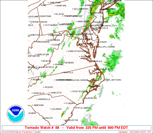
The NWS Storm Prediction Center has issued a
* Tornado Watch for portions of
Eastern Maryland
Northeast North Carolina
Southeast Virginia
Coastal Waters
* Effective this Thursday afternoon and evening from 225 PM until
800 PM EDT.
* Primary threats include...
A few tornadoes possible
Scattered damaging wind gusts to 70 mph possible
SUMMARY...Scattered thunderstorms will affect the watch area through
the afternoon, will occasional supercell storms. Locally damaging
wind gusts and isolated tornadoes are possible.
The tornado watch area is approximately along and 60 statute miles
east and west of a line from 5 miles northeast of Patuxent River MD
to 35 miles south southeast of Raleigh NC. For a complete depiction
of the watch see the associated watch outline update (WOUS64 KWNS
WOU8).
PRECAUTIONARY/PREPAREDNESS ACTIONS...
REMEMBER...A Tornado Watch means conditions are favorable for
tornadoes and severe thunderstorms in and close to the watch
area. Persons in these areas should be on the lookout for
threatening weather conditions and listen for later statements
and possible warnings.
&&
OTHER WATCH INFORMATION...CONTINUE...WW 86...WW 87...
AVIATION...Tornadoes and a few severe thunderstorms with hail
surface and aloft to 0.5 inches. Extreme turbulence and surface wind
gusts to 60 knots. A few cumulonimbi with maximum tops to 500. Mean
storm motion vector 23035.
...Hart
   SEL8

   URGENT - IMMEDIATE BROADCAST REQUESTED
   Tornado Watch Number 88
   NWS Storm Prediction Center Norman OK
   225 PM EDT Thu Mar 31 2022

   The NWS Storm Prediction Center has issued a

   * Tornado Watch for portions of
     Eastern Maryland
     Northeast North Carolina
     Southeast Virginia
     Coastal Waters

   * Effective this Thursday afternoon and evening from 225 PM until
     800 PM EDT.

   * Primary threats include...
     A few tornadoes possible
     Scattered damaging wind gusts to 70 mph possible

   SUMMARY...Scattered thunderstorms will affect the watch area through
   the afternoon, will occasional supercell storms.  Locally damaging
   wind gusts and isolated tornadoes are possible.

   The tornado watch area is approximately along and 60 statute miles
   east and west of a line from 5 miles northeast of Patuxent River MD
   to 35 miles south southeast of Raleigh NC. For a complete depiction
   of the watch see the associated watch outline update (WOUS64 KWNS
   WOU8).

   PRECAUTIONARY/PREPAREDNESS ACTIONS...

   REMEMBER...A Tornado Watch means conditions are favorable for
   tornadoes and severe thunderstorms in and close to the watch
   area. Persons in these areas should be on the lookout for
   threatening weather conditions and listen for later statements
   and possible warnings.

   &&

   OTHER WATCH INFORMATION...CONTINUE...WW 86...WW 87...

   AVIATION...Tornadoes and a few severe thunderstorms with hail
   surface and aloft to 0.5 inches. Extreme turbulence and surface wind
   gusts to 60 knots. A few cumulonimbi with maximum tops to 500. Mean
   storm motion vector 23035.

   ...Hart
 Note:
The Aviation Watch (SAW) product is an approximation to the watch area.
The actual watch is depicted by the shaded areas.
Note:
The Aviation Watch (SAW) product is an approximation to the watch area.
The actual watch is depicted by the shaded areas.
SAW8
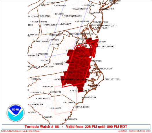
WW 88 TORNADO MD NC VA CW 311825Z - 010000Z
AXIS..60 STATUTE MILES EAST AND WEST OF LINE..
5NE NHK/PATUXENT RIVER MD/ - 35SSE RDU/RALEIGH NC/
..AVIATION COORDS.. 50NM E/W /39W SBY - 31SSE RDU/
HAIL SURFACE AND ALOFT..0.5 INCH. WIND GUSTS..60 KNOTS.
MAX TOPS TO 500. MEAN STORM MOTION VECTOR 23035.
LAT...LON 38337525 35397748 35397961 38337746
THIS IS AN APPROXIMATION TO THE WATCH AREA. FOR A
COMPLETE DEPICTION OF THE WATCH SEE WOUS64 KWNS
FOR WOU8.
Watch 88 Status Report Messages:
STATUS REPORT #6 ON WW 88

VALID 312335Z - 010040Z

SEVERE WEATHER THREAT CONTINUES RIGHT OF A LINE FROM 15 SW OAJ TO
25 ESE GSB TO 30 ESE RZZ TO 40 W ORF TO 10 N NHK.

FOR ADDITIONAL INFORMATION SEE MESOSCALE DISCUSSION 380

..MOORE..03/31/22

ATTN...WFO...AKQ...RAH...MHX...

&&

STATUS REPORT FOR WT 88

SEVERE WEATHER THREAT CONTINUES FOR THE FOLLOWING AREAS

MDC019-039-045-047-010040-

MD
.    MARYLAND COUNTIES INCLUDED ARE

DORCHESTER	     SOMERSET		 WICOMICO
WORCESTER
$$


NCC013-015-031-049-055-073-091-095-103-117-137-177-187-010040-

NC
.    NORTH CAROLINA COUNTIES INCLUDED ARE

BEAUFORT	     BERTIE		 CARTERET
CRAVEN		     DARE		 GATES
HERTFORD	     HYDE		 JONES
MARTIN		     PAMLICO		 TYRRELL
WASHINGTON
$$


VAC001-073-093-095-103-115-119-131-133-199-650-700-735-800-830-
010040-

VA
.    VIRGINIA COUNTIES INCLUDED ARE

ACCOMACK	     GLOUCESTER 	 ISLE OF WIGHT
JAMES CITY	     LANCASTER		 MATHEWS
MIDDLESEX	     NORTHAMPTON	 NORTHUMBERLAND
YORK


VIRGINIA INDEPENDENT CITIES INCLUDED ARE

HAMPTON 	     NEWPORT NEWS	 POQUOSON
SUFFOLK 	     WILLIAMSBURG
$$


AMZ131-158-ANZ630-631-632-635-636-637-638-010040-

CW

.    ADJACENT COASTAL WATERS INCLUDED ARE

ALLIGATOR RIVER

S OF CAPE LOOKOUT NC TO SURF CITY NC OUT TO 20 NM

CHESAPEAKE BAY FROM SMITH POINT TO WINDMILL POINT VA

CHESAPEAKE BAY FROM WINDMILL POINT TO NEW POINT COMFORT VA

CHESAPEAKE BAY FROM NEW POINT COMFORT TO LITTLE CREEK VA

RAPPAHANNOCK RIVER FROM URBANNA TO WINDMILL POINT

YORK RIVER

JAMES RIVER FROM JAMESTOWN TO THE JAMES RIVER BRIDGE

JAMES RIVER FROM JAMES RIVER BRIDGE TO HAMPTON ROADS
BRIDGE-TUNNEL

$$
THE WATCH STATUS MESSAGE IS FOR GUIDANCE PURPOSES ONLY.  PLEASE
REFER TO WATCH COUNTY NOTIFICATION STATEMENTS FOR OFFICIAL
INFORMATION ON COUNTIES...INDEPENDENT CITIES AND MARINE ZONES
CLEARED FROM SEVERE THUNDERSTORM AND TORNADO WATCHES.
$$

STATUS REPORT #5 ON WW 88

VALID 312320Z - 010040Z

SEVERE WEATHER THREAT CONTINUES RIGHT OF A LINE FROM 20 SW OAJ TO
30 E GSB TO 35 ESE RWI TO 35 ENE RZZ TO 15 NNW NHK.

FOR ADDITIONAL INFORMATION SEE MESOSCALE DISCUSSION 380

..MOORE..03/31/22

ATTN...WFO...AKQ...RAH...MHX...

&&

STATUS REPORT FOR WT 88

SEVERE WEATHER THREAT CONTINUES FOR THE FOLLOWING AREAS

MDC019-039-045-047-010040-

MD
.    MARYLAND COUNTIES INCLUDED ARE

DORCHESTER	     SOMERSET		 WICOMICO
WORCESTER
$$


NCC013-015-031-049-055-073-091-095-103-117-137-177-187-010040-

NC
.    NORTH CAROLINA COUNTIES INCLUDED ARE

BEAUFORT	     BERTIE		 CARTERET
CRAVEN		     DARE		 GATES
HERTFORD	     HYDE		 JONES
MARTIN		     PAMLICO		 TYRRELL
WASHINGTON
$$


VAC001-073-093-095-103-115-119-131-133-175-181-199-620-650-700-
735-800-830-010040-

VA
.    VIRGINIA COUNTIES INCLUDED ARE

ACCOMACK	     GLOUCESTER 	 ISLE OF WIGHT
JAMES CITY	     LANCASTER		 MATHEWS
MIDDLESEX	     NORTHAMPTON	 NORTHUMBERLAND
SOUTHAMPTON	     SURRY		 YORK


VIRGINIA INDEPENDENT CITIES INCLUDED ARE

FRANKLIN	     HAMPTON		 NEWPORT NEWS
POQUOSON	     SUFFOLK		 WILLIAMSBURG
$$


AMZ131-158-ANZ630-631-632-635-636-637-638-010040-

CW

.    ADJACENT COASTAL WATERS INCLUDED ARE

ALLIGATOR RIVER

S OF CAPE LOOKOUT NC TO SURF CITY NC OUT TO 20 NM

CHESAPEAKE BAY FROM SMITH POINT TO WINDMILL POINT VA

CHESAPEAKE BAY FROM WINDMILL POINT TO NEW POINT COMFORT VA

CHESAPEAKE BAY FROM NEW POINT COMFORT TO LITTLE CREEK VA

RAPPAHANNOCK RIVER FROM URBANNA TO WINDMILL POINT

YORK RIVER

JAMES RIVER FROM JAMESTOWN TO THE JAMES RIVER BRIDGE

JAMES RIVER FROM JAMES RIVER BRIDGE TO HAMPTON ROADS
BRIDGE-TUNNEL

$$
THE WATCH STATUS MESSAGE IS FOR GUIDANCE PURPOSES ONLY.  PLEASE
REFER TO WATCH COUNTY NOTIFICATION STATEMENTS FOR OFFICIAL
INFORMATION ON COUNTIES...INDEPENDENT CITIES AND MARINE ZONES
CLEARED FROM SEVERE THUNDERSTORM AND TORNADO WATCHES.
$$

STATUS REPORT #4 ON WW 88

VALID 312230Z - 312340Z

SEVERE WEATHER THREAT CONTINUES RIGHT OF A LINE FROM 30 SW GSB TO
20 N RWI TO 35 SSW RIC TO 10 SE RIC TO 10 NW NHK.

FOR ADDITIONAL INFORMATION SEE MESOSCALE DISCUSSION 380

..MOORE..03/31/22

ATTN...WFO...AKQ...RAH...MHX...

&&

STATUS REPORT FOR WT 88

SEVERE WEATHER THREAT CONTINUES FOR THE FOLLOWING AREAS

MDC019-039-045-047-312340-

MD
.    MARYLAND COUNTIES INCLUDED ARE

DORCHESTER	     SOMERSET		 WICOMICO
WORCESTER
$$


NCC015-061-065-073-079-083-091-107-117-131-147-195-312340-

NC
.    NORTH CAROLINA COUNTIES INCLUDED ARE

BERTIE		     DUPLIN		 EDGECOMBE
GATES		     GREENE		 HALIFAX
HERTFORD	     LENOIR		 MARTIN
NORTHAMPTON	     PITT		 WILSON
$$


VAC001-073-081-093-095-103-115-119-131-133-175-181-183-199-595-
620-650-700-735-800-830-312340-

VA
.    VIRGINIA COUNTIES INCLUDED ARE

ACCOMACK	     GLOUCESTER 	 GREENSVILLE
ISLE OF WIGHT	     JAMES CITY 	 LANCASTER
MATHEWS 	     MIDDLESEX		 NORTHAMPTON
NORTHUMBERLAND	     SOUTHAMPTON	 SURRY
SUSSEX		     YORK


VIRGINIA INDEPENDENT CITIES INCLUDED ARE

EMPORIA 	     FRANKLIN		 HAMPTON
NEWPORT NEWS	     POQUOSON		 SUFFOLK
WILLIAMSBURG
$$


ANZ630-631-632-635-636-637-638-312340-

CW

.    ADJACENT COASTAL WATERS INCLUDED ARE

CHESAPEAKE BAY FROM SMITH POINT TO WINDMILL POINT VA

CHESAPEAKE BAY FROM WINDMILL POINT TO NEW POINT COMFORT VA

CHESAPEAKE BAY FROM NEW POINT COMFORT TO LITTLE CREEK VA

RAPPAHANNOCK RIVER FROM URBANNA TO WINDMILL POINT

YORK RIVER

JAMES RIVER FROM JAMESTOWN TO THE JAMES RIVER BRIDGE

JAMES RIVER FROM JAMES RIVER BRIDGE TO HAMPTON ROADS
BRIDGE-TUNNEL

$$
THE WATCH STATUS MESSAGE IS FOR GUIDANCE PURPOSES ONLY.  PLEASE
REFER TO WATCH COUNTY NOTIFICATION STATEMENTS FOR OFFICIAL
INFORMATION ON COUNTIES...INDEPENDENT CITIES AND MARINE ZONES
CLEARED FROM SEVERE THUNDERSTORM AND TORNADO WATCHES.
$$

STATUS REPORT #3 ON WW 88

VALID 312145Z - 312240Z

SEVERE WEATHER THREAT CONTINUES RIGHT OF A LINE FROM SOP TO 5 SW
RDU TO AVC TO 35 S CHO.

..MOORE..03/31/22

ATTN...WFO...AKQ...RAH...MHX...

&&

STATUS REPORT FOR WT 88

SEVERE WEATHER THREAT CONTINUES FOR THE FOLLOWING AREAS

MDC019-039-045-047-312240-

MD
.    MARYLAND COUNTIES INCLUDED ARE

DORCHESTER	     SOMERSET		 WICOMICO
WORCESTER
$$


NCC015-061-065-069-073-079-083-091-101-107-117-127-131-147-183-
185-191-195-312240-

NC
.    NORTH CAROLINA COUNTIES INCLUDED ARE

BERTIE		     DUPLIN		 EDGECOMBE
FRANKLIN	     GATES		 GREENE
HALIFAX 	     HERTFORD		 JOHNSTON
LENOIR		     MARTIN		 NASH
NORTHAMPTON	     PITT		 WAKE
WARREN		     WAYNE		 WILSON
$$


VAC001-007-025-033-036-041-049-053-057-065-073-075-081-085-087-
093-095-097-101-103-109-115-119-127-131-133-135-145-149-159-175-
181-183-193-199-570-595-620-650-670-700-730-735-760-800-830-
312240-

VA
.    VIRGINIA COUNTIES INCLUDED ARE

ACCOMACK	     AMELIA		 BRUNSWICK
CAROLINE	     CHARLES CITY	 CHESTERFIELD
CUMBERLAND	     DINWIDDIE		 ESSEX
FLUVANNA	     GLOUCESTER 	 GOOCHLAND
GREENSVILLE	     HANOVER		 HENRICO
ISLE OF WIGHT	     JAMES CITY 	 KING AND QUEEN
KING WILLIAM	     LANCASTER		 LOUISA
MATHEWS 	     MIDDLESEX		 NEW KENT
NORTHAMPTON	     NORTHUMBERLAND	 NOTTOWAY
POWHATAN	     PRINCE GEORGE	 RICHMOND
SOUTHAMPTON	     SURRY		 SUSSEX
WESTMORELAND	     YORK


VIRGINIA INDEPENDENT CITIES INCLUDED ARE

COLONIAL HEIGHTS     EMPORIA		 FRANKLIN
HAMPTON 	     HOPEWELL		 NEWPORT NEWS
PETERSBURG	     POQUOSON		 RICHMOND
SUFFOLK 	     WILLIAMSBURG
$$


ANZ630-631-632-635-636-637-638-312240-

CW

.    ADJACENT COASTAL WATERS INCLUDED ARE

CHESAPEAKE BAY FROM SMITH POINT TO WINDMILL POINT VA

CHESAPEAKE BAY FROM WINDMILL POINT TO NEW POINT COMFORT VA

CHESAPEAKE BAY FROM NEW POINT COMFORT TO LITTLE CREEK VA

RAPPAHANNOCK RIVER FROM URBANNA TO WINDMILL POINT

YORK RIVER

JAMES RIVER FROM JAMESTOWN TO THE JAMES RIVER BRIDGE

JAMES RIVER FROM JAMES RIVER BRIDGE TO HAMPTON ROADS
BRIDGE-TUNNEL

$$
THE WATCH STATUS MESSAGE IS FOR GUIDANCE PURPOSES ONLY.  PLEASE
REFER TO WATCH COUNTY NOTIFICATION STATEMENTS FOR OFFICIAL
INFORMATION ON COUNTIES...INDEPENDENT CITIES AND MARINE ZONES
CLEARED FROM SEVERE THUNDERSTORM AND TORNADO WATCHES.
$$

STATUS REPORT #2 ON WW 88

VALID 312020Z - 312140Z

THE SEVERE WEATHER THREAT CONTINUES ACROSS THE ENTIRE WATCH AREA.

..KERR..03/31/22

ATTN...WFO...AKQ...RAH...MHX...

&&

STATUS REPORT FOR WT 88

SEVERE WEATHER THREAT CONTINUES FOR THE FOLLOWING AREAS

MDC019-039-045-047-312140-

MD
.    MARYLAND COUNTIES INCLUDED ARE

DORCHESTER	     SOMERSET		 WICOMICO
WORCESTER
$$


NCC001-015-037-061-063-065-069-073-077-079-083-091-101-107-117-
127-131-135-145-147-181-183-185-191-195-312140-

NC
.    NORTH CAROLINA COUNTIES INCLUDED ARE

ALAMANCE	     BERTIE		 CHATHAM
DUPLIN		     DURHAM		 EDGECOMBE
FRANKLIN	     GATES		 GRANVILLE
GREENE		     HALIFAX		 HERTFORD
JOHNSTON	     LENOIR		 MARTIN
NASH		     NORTHAMPTON	 ORANGE
PERSON		     PITT		 VANCE
WAKE		     WARREN		 WAYNE
WILSON
$$


VAC001-007-025-033-036-041-049-053-057-065-073-075-081-085-087-
093-095-097-101-103-109-111-115-117-119-127-131-133-135-145-147-
149-159-175-181-183-193-199-570-595-620-650-670-700-730-735-760-
800-830-312140-

VA
.    VIRGINIA COUNTIES INCLUDED ARE

ACCOMACK	     AMELIA		 BRUNSWICK
CAROLINE	     CHARLES CITY	 CHESTERFIELD
CUMBERLAND	     DINWIDDIE		 ESSEX
FLUVANNA	     GLOUCESTER 	 GOOCHLAND
GREENSVILLE	     HANOVER		 HENRICO
ISLE OF WIGHT	     JAMES CITY 	 KING AND QUEEN
KING WILLIAM	     LANCASTER		 LOUISA
LUNENBURG	     MATHEWS		 MECKLENBURG
MIDDLESEX	     NEW KENT		 NORTHAMPTON
NORTHUMBERLAND	     NOTTOWAY		 POWHATAN
PRINCE EDWARD	     PRINCE GEORGE	 RICHMOND
SOUTHAMPTON	     SURRY		 SUSSEX
WESTMORELAND	     YORK


VIRGINIA INDEPENDENT CITIES INCLUDED ARE

COLONIAL HEIGHTS     EMPORIA		 FRANKLIN
HAMPTON 	     HOPEWELL		 NEWPORT NEWS
PETERSBURG	     POQUOSON		 RICHMOND
SUFFOLK 	     WILLIAMSBURG
$$


ANZ630-631-635-636-637-638-312140-

CW

.    ADJACENT COASTAL WATERS INCLUDED ARE

CHESAPEAKE BAY FROM SMITH POINT TO WINDMILL POINT VA

CHESAPEAKE BAY FROM WINDMILL POINT TO NEW POINT COMFORT VA

RAPPAHANNOCK RIVER FROM URBANNA TO WINDMILL POINT

YORK RIVER

JAMES RIVER FROM JAMESTOWN TO THE JAMES RIVER BRIDGE

JAMES RIVER FROM JAMES RIVER BRIDGE TO HAMPTON ROADS
BRIDGE-TUNNEL

$$
THE WATCH STATUS MESSAGE IS FOR GUIDANCE PURPOSES ONLY.  PLEASE
REFER TO WATCH COUNTY NOTIFICATION STATEMENTS FOR OFFICIAL
INFORMATION ON COUNTIES...INDEPENDENT CITIES AND MARINE ZONES
CLEARED FROM SEVERE THUNDERSTORM AND TORNADO WATCHES.
$$

STATUS REPORT #1 ON WW 88

VALID 311930Z - 312040Z

THE SEVERE WEATHER THREAT CONTINUES ACROSS THE ENTIRE WATCH AREA.

..KERR..03/31/22

ATTN...WFO...AKQ...RAH...MHX...

&&

STATUS REPORT FOR WT 88

SEVERE WEATHER THREAT CONTINUES FOR THE FOLLOWING AREAS

MDC019-039-045-047-312040-

MD
.    MARYLAND COUNTIES INCLUDED ARE

DORCHESTER	     SOMERSET		 WICOMICO
WORCESTER
$$


NCC001-015-037-061-063-065-069-073-077-079-083-091-101-107-117-
127-131-135-145-147-181-183-185-191-195-312040-

NC
.    NORTH CAROLINA COUNTIES INCLUDED ARE

ALAMANCE	     BERTIE		 CHATHAM
DUPLIN		     DURHAM		 EDGECOMBE
FRANKLIN	     GATES		 GRANVILLE
GREENE		     HALIFAX		 HERTFORD
JOHNSTON	     LENOIR		 MARTIN
NASH		     NORTHAMPTON	 ORANGE
PERSON		     PITT		 VANCE
WAKE		     WARREN		 WAYNE
WILSON
$$


VAC001-007-025-033-036-041-049-053-057-065-073-075-081-085-087-
093-095-097-101-103-109-111-115-117-119-127-131-133-135-145-147-
149-159-175-181-183-193-199-570-595-620-650-670-700-730-735-760-
800-830-312040-

VA
.    VIRGINIA COUNTIES INCLUDED ARE

ACCOMACK	     AMELIA		 BRUNSWICK
CAROLINE	     CHARLES CITY	 CHESTERFIELD
CUMBERLAND	     DINWIDDIE		 ESSEX
FLUVANNA	     GLOUCESTER 	 GOOCHLAND
GREENSVILLE	     HANOVER		 HENRICO
ISLE OF WIGHT	     JAMES CITY 	 KING AND QUEEN
KING WILLIAM	     LANCASTER		 LOUISA
LUNENBURG	     MATHEWS		 MECKLENBURG
MIDDLESEX	     NEW KENT		 NORTHAMPTON
NORTHUMBERLAND	     NOTTOWAY		 POWHATAN
PRINCE EDWARD	     PRINCE GEORGE	 RICHMOND
SOUTHAMPTON	     SURRY		 SUSSEX
WESTMORELAND	     YORK


VIRGINIA INDEPENDENT CITIES INCLUDED ARE

COLONIAL HEIGHTS     EMPORIA		 FRANKLIN
HAMPTON 	     HOPEWELL		 NEWPORT NEWS
PETERSBURG	     POQUOSON		 RICHMOND
SUFFOLK 	     WILLIAMSBURG
$$


ANZ630-631-635-636-637-638-312040-

CW

.    ADJACENT COASTAL WATERS INCLUDED ARE

CHESAPEAKE BAY FROM SMITH POINT TO WINDMILL POINT VA

CHESAPEAKE BAY FROM WINDMILL POINT TO NEW POINT COMFORT VA

RAPPAHANNOCK RIVER FROM URBANNA TO WINDMILL POINT

YORK RIVER

JAMES RIVER FROM JAMESTOWN TO THE JAMES RIVER BRIDGE

JAMES RIVER FROM JAMES RIVER BRIDGE TO HAMPTON ROADS
BRIDGE-TUNNEL

$$
THE WATCH STATUS MESSAGE IS FOR GUIDANCE PURPOSES ONLY.  PLEASE
REFER TO WATCH COUNTY NOTIFICATION STATEMENTS FOR OFFICIAL
INFORMATION ON COUNTIES...INDEPENDENT CITIES AND MARINE ZONES
CLEARED FROM SEVERE THUNDERSTORM AND TORNADO WATCHES.
$$
Note:
Click for Complete Product Text.
Tornadoes
Probability of 2 or more tornadoes
|
Mod (50%)
|
Probability of 1 or more strong (EF2-EF5) tornadoes
|
Low (20%)
|
Wind
Probability of 10 or more severe wind events
|
Mod (40%)
|
Probability of 1 or more wind events > 65 knots
|
Low (20%)
|
Hail
Probability of 10 or more severe hail events
|
Low (10%)
|
Probability of 1 or more hailstones > 2 inches
|
Low (<5%)
|
Combined Severe Hail/Wind
Probability of 6 or more combined severe hail/wind events
|
Mod (60%)
|
For each watch, probabilities for particular events inside the watch
(listed above in each table) are determined by the issuing forecaster.
The "Low" category contains probability values ranging from less than 2%
to 20% (EF2-EF5 tornadoes), less than 5% to 20% (all other probabilities),
"Moderate" from 30% to 60%, and "High" from 70% to greater than 95%.
High values are bolded and lighter in color to provide awareness of
an increased threat for a particular event.


 @NWSSPC


