 Note:
The expiration time in the watch graphic is amended if the watch is
replaced, cancelled or extended.
Note:
Note:
The expiration time in the watch graphic is amended if the watch is
replaced, cancelled or extended.
Note: Click for
Watch Status Reports.
SEL0
URGENT - IMMEDIATE BROADCAST REQUESTED
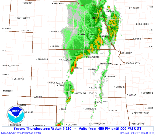
Severe Thunderstorm Watch Number 210
NWS Storm Prediction Center Norman OK
450 PM CDT Thu May 12 2022
The NWS Storm Prediction Center has issued a
* Severe Thunderstorm Watch for portions of
Central Kansas
* Effective this Thursday afternoon and evening from 450 PM until
900 PM CDT.
* Primary threats include...
Scattered damaging winds likely with isolated significant gusts
to 75 mph possible
Scattered large hail likely with isolated very large hail events
to 2 inches in diameter possible
SUMMARY...Thunderstorms are developing southward along a surface
boundary across central Kansas. Any storm that can persist in this
area will pose a risk of damaging wind gusts and hail through the
late afternoon.
The severe thunderstorm watch area is approximately along and 30
statute miles east and west of a line from 30 miles north northeast
of Concordia KS to 80 miles southwest of Salina KS. For a complete
depiction of the watch see the associated watch outline update
(WOUS64 KWNS WOU0).
PRECAUTIONARY/PREPAREDNESS ACTIONS...
REMEMBER...A Severe Thunderstorm Watch means conditions are
favorable for severe thunderstorms in and close to the watch area.
Persons in these areas should be on the lookout for threatening
weather conditions and listen for later statements and possible
warnings. Severe thunderstorms can and occasionally do produce
tornadoes.
&&
OTHER WATCH INFORMATION...CONTINUE...WW 205...WW 206...WW
207...WW 208...WW 209...
AVIATION...A few severe thunderstorms with hail surface and aloft to
2 inches. Extreme turbulence and surface wind gusts to 65 knots. A
few cumulonimbi with maximum tops to 500. Mean storm motion vector
23035.
...Hart
 Note:
The Aviation Watch (SAW) product is an approximation to the watch area.
The actual watch is depicted by the shaded areas.
Note:
The Aviation Watch (SAW) product is an approximation to the watch area.
The actual watch is depicted by the shaded areas.
   SAW0
   WW 210 SEVERE TSTM KS 122150Z - 130200Z
   AXIS..30 STATUTE MILES EAST AND WEST OF LINE..
   30NNE CNK/CONCORDIA KS/ - 80SW SLN/SALINA KS/
   ..AVIATION COORDS.. 25NM E/W /58WSW PWE - 54WNW ICT/
   HAIL SURFACE AND ALOFT..2 INCHES. WIND GUSTS..65 KNOTS.
   MAX TOPS TO 500. MEAN STORM MOTION VECTOR 23035.

   LAT...LON 39939687 37979814 37979924 39939800

   THIS IS AN APPROXIMATION TO THE WATCH AREA.  FOR A
   COMPLETE DEPICTION OF THE WATCH SEE WOUS64 KWNS
   FOR WOU0.
Watch 210 Status Report Messages:
STATUS REPORT #4 ON WW 210
VALID 130150Z - 130200Z
THE SEVERE WEATHER THREAT CONTINUES ACROSS THE ENTIRE WATCH AREA.
WW 210 WILL BE ALLOWED TO EXPIRE AT 130200Z.
..BENTLEY..05/13/22
ATTN...WFO...ICT...TOP...DDC...
&&
STATUS REPORT FOR WS 210
SEVERE WEATHER THREAT CONTINUES FOR THE FOLLOWING AREAS
KSC009-027-029-053-105-143-157-167-185-201-130200-
KS
. KANSAS COUNTIES INCLUDED ARE
BARTON CLAY CLOUD
ELLSWORTH LINCOLN OTTAWA
REPUBLIC RUSSELL STAFFORD
WASHINGTON
$$
THE WATCH STATUS MESSAGE IS FOR GUIDANCE PURPOSES ONLY. PLEASE
REFER TO WATCH COUNTY NOTIFICATION STATEMENTS FOR OFFICIAL
INFORMATION ON COUNTIES...INDEPENDENT CITIES AND MARINE ZONES
CLEARED FROM SEVERE THUNDERSTORM AND TORNADO WATCHES.
$$
STATUS REPORT #3 ON WW 210
VALID 130025Z - 130140Z
THE SEVERE WEATHER THREAT CONTINUES ACROSS THE ENTIRE WATCH AREA.
..MOORE..05/13/22
ATTN...WFO...ICT...TOP...DDC...
&&
STATUS REPORT FOR WS 210
SEVERE WEATHER THREAT CONTINUES FOR THE FOLLOWING AREAS
KSC009-027-029-053-105-143-157-167-185-201-130140-
KS
. KANSAS COUNTIES INCLUDED ARE
BARTON CLAY CLOUD
ELLSWORTH LINCOLN OTTAWA
REPUBLIC RUSSELL STAFFORD
WASHINGTON
$$
THE WATCH STATUS MESSAGE IS FOR GUIDANCE PURPOSES ONLY. PLEASE
REFER TO WATCH COUNTY NOTIFICATION STATEMENTS FOR OFFICIAL
INFORMATION ON COUNTIES...INDEPENDENT CITIES AND MARINE ZONES
CLEARED FROM SEVERE THUNDERSTORM AND TORNADO WATCHES.
$$
STATUS REPORT #2 ON WW 210
VALID 122325Z - 130040Z
THE SEVERE WEATHER THREAT CONTINUES ACROSS THE ENTIRE WATCH AREA.
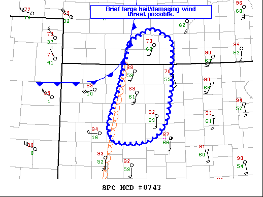
FOR ADDITIONAL INFORMATION SEE MESOSCALE DISCUSSION 743
..MOORE..05/12/22
ATTN...WFO...ICT...TOP...DDC...
&&
STATUS REPORT FOR WS 210
SEVERE WEATHER THREAT CONTINUES FOR THE FOLLOWING AREAS
KSC009-027-029-053-105-143-157-167-185-201-130040-
KS
. KANSAS COUNTIES INCLUDED ARE
BARTON CLAY CLOUD
ELLSWORTH LINCOLN OTTAWA
REPUBLIC RUSSELL STAFFORD
WASHINGTON
$$
THE WATCH STATUS MESSAGE IS FOR GUIDANCE PURPOSES ONLY. PLEASE
REFER TO WATCH COUNTY NOTIFICATION STATEMENTS FOR OFFICIAL
INFORMATION ON COUNTIES...INDEPENDENT CITIES AND MARINE ZONES
CLEARED FROM SEVERE THUNDERSTORM AND TORNADO WATCHES.
$$
STATUS REPORT #1 ON WW 210
VALID 122230Z - 122340Z
THE SEVERE WEATHER THREAT CONTINUES ACROSS THE ENTIRE WATCH AREA.
FOR ADDITIONAL INFORMATION SEE MESOSCALE DISCUSSION 741
..MOORE..05/12/22
ATTN...WFO...ICT...TOP...DDC...
&&
STATUS REPORT FOR WS 210
SEVERE WEATHER THREAT CONTINUES FOR THE FOLLOWING AREAS
KSC009-027-029-053-105-143-157-167-185-201-122340-
KS
. KANSAS COUNTIES INCLUDED ARE
BARTON CLAY CLOUD
ELLSWORTH LINCOLN OTTAWA
REPUBLIC RUSSELL STAFFORD
WASHINGTON
$$
THE WATCH STATUS MESSAGE IS FOR GUIDANCE PURPOSES ONLY. PLEASE
REFER TO WATCH COUNTY NOTIFICATION STATEMENTS FOR OFFICIAL
INFORMATION ON COUNTIES...INDEPENDENT CITIES AND MARINE ZONES
CLEARED FROM SEVERE THUNDERSTORM AND TORNADO WATCHES.
$$
Note:
Click for Complete Product Text.
Tornadoes
Probability of 2 or more tornadoes
|
Low (<5%)
|
Probability of 1 or more strong (EF2-EF5) tornadoes
|
Low (<2%)
|
Wind
Probability of 10 or more severe wind events
|
High (70%)
|
Probability of 1 or more wind events > 65 knots
|
Mod (30%)
|
Hail
Probability of 10 or more severe hail events
|
Mod (60%)
|
Probability of 1 or more hailstones > 2 inches
|
Mod (30%)
|
Combined Severe Hail/Wind
Probability of 6 or more combined severe hail/wind events
|
High (>95%)
|
For each watch, probabilities for particular events inside the watch
(listed above in each table) are determined by the issuing forecaster.
The "Low" category contains probability values ranging from less than 2%
to 20% (EF2-EF5 tornadoes), less than 5% to 20% (all other probabilities),
"Moderate" from 30% to 60%, and "High" from 70% to greater than 95%.
High values are bolded and lighter in color to provide awareness of
an increased threat for a particular event.


 @NWSSPC