 Note:
The expiration time in the watch graphic is amended if the watch is
replaced, cancelled or extended.
Note:
Note:
The expiration time in the watch graphic is amended if the watch is
replaced, cancelled or extended.
Note: Click for
Watch Status Reports.
SEL1
URGENT - IMMEDIATE BROADCAST REQUESTED
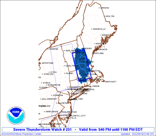
Severe Thunderstorm Watch Number 231
NWS Storm Prediction Center Norman OK
540 PM EDT Mon May 16 2022
The NWS Storm Prediction Center has issued a
* Severe Thunderstorm Watch for portions of
Northeast Connecticut
Eastern Massachusetts
Southern New Hampshire
* Effective this Monday afternoon and evening from 540 PM until
1100 PM EDT.
* Primary threats include...
Scattered damaging wind gusts to 65 mph possible
Scattered large hail events to 1.5 inches in diameter possible
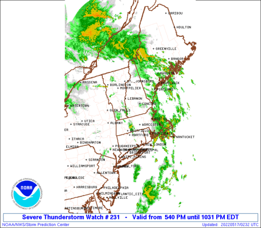
SUMMARY...Thunderstorms along the Hudson Valley are tracking
eastward and will affect the watch area late this afternoon. The
strongest cells will pose a risk of locally damaging wind gusts.
The severe thunderstorm watch area is approximately along and 35
statute miles east and west of a line from 40 miles north northwest
of Laconia NH to 30 miles south of Worcester MA. For a complete
depiction of the watch see the associated watch outline update
(WOUS64 KWNS WOU1).
PRECAUTIONARY/PREPAREDNESS ACTIONS...
REMEMBER...A Severe Thunderstorm Watch means conditions are
favorable for severe thunderstorms in and close to the watch area.
Persons in these areas should be on the lookout for threatening
weather conditions and listen for later statements and possible
warnings. Severe thunderstorms can and occasionally do produce
tornadoes.
&&
OTHER WATCH INFORMATION...CONTINUE...WW 227...WW 228...WW
229...WW 230...
AVIATION...A few severe thunderstorms with hail surface and aloft to
1.5 inches. Extreme turbulence and surface wind gusts to 55 knots. A
few cumulonimbi with maximum tops to 500. Mean storm motion vector
24035.
...Hart
 Note:
The Aviation Watch (SAW) product is an approximation to the watch area.
The actual watch is depicted by the shaded areas.
Note:
The Aviation Watch (SAW) product is an approximation to the watch area.
The actual watch is depicted by the shaded areas.
   SAW1
   WW 231 SEVERE TSTM CT MA NH 162140Z - 170300Z
   AXIS..35 STATUTE MILES EAST AND WEST OF LINE..
   40NNW LCI/LACONIA NH/ - 30S ORH/WORCESTER MA/
   ..AVIATION COORDS.. 30NM E/W /37E MPV - 21WNW PVD/
   HAIL SURFACE AND ALOFT..1.5 INCHES. WIND GUSTS..55 KNOTS.
   MAX TOPS TO 500. MEAN STORM MOTION VECTOR 24035.

   LAT...LON 44107101 41837119 41837256 44107243

   THIS IS AN APPROXIMATION TO THE WATCH AREA.  FOR A
   COMPLETE DEPICTION OF THE WATCH SEE WOUS64 KWNS
   FOR WOU1.
Watch 231 Status Report Messages:
STATUS REPORT #2 ON WW 231

VALID 162315Z - 170040Z

SEVERE WEATHER THREAT CONTINUES RIGHT OF A LINE FROM 15 SE BDL TO
20 ENE BAF TO 10 S EEN TO 20 W CON TO 15 SSW MPV.

..SQUITIERI..05/16/22

ATTN...WFO...BOX...GYX...

&&

STATUS REPORT FOR WS 231

SEVERE WEATHER THREAT CONTINUES FOR THE FOLLOWING AREAS

CTC013-015-170040-

CT
.    CONNECTICUT COUNTIES INCLUDED ARE

TOLLAND 	     WINDHAM
$$


MAC017-027-170040-

MA
.    MASSACHUSETTS COUNTIES INCLUDED ARE

MIDDLESEX	     WORCESTER
$$


NHC001-003-009-011-013-015-017-170040-

NH
.    NEW HAMPSHIRE COUNTIES INCLUDED ARE

BELKNAP 	     CARROLL		 GRAFTON
HILLSBOROUGH	     MERRIMACK		 ROCKINGHAM
STRAFFORD
$$


THE WATCH STATUS MESSAGE IS FOR GUIDANCE PURPOSES ONLY.  PLEASE
REFER TO WATCH COUNTY NOTIFICATION STATEMENTS FOR OFFICIAL
INFORMATION ON COUNTIES...INDEPENDENT CITIES AND MARINE ZONES
CLEARED FROM SEVERE THUNDERSTORM AND TORNADO WATCHES.
$$

STATUS REPORT #1 ON WW 231

VALID 162250Z - 162340Z

SEVERE WEATHER THREAT CONTINUES RIGHT OF A LINE FROM 25 SW EEN TO
5 NNW EEN TO 20 NW LEB.

FOR ADDITIONAL INFORMATION SEE MESOSCALE DISCUSSION 795

..SQUITIERI..05/16/22

ATTN...WFO...BOX...GYX...

&&

STATUS REPORT FOR WS 231

SEVERE WEATHER THREAT CONTINUES FOR THE FOLLOWING AREAS

CTC013-015-162340-

CT
.    CONNECTICUT COUNTIES INCLUDED ARE

TOLLAND 	     WINDHAM
$$


MAC017-027-162340-

MA
.    MASSACHUSETTS COUNTIES INCLUDED ARE

MIDDLESEX	     WORCESTER
$$


NHC001-003-005-009-011-013-015-017-019-162340-

NH
.    NEW HAMPSHIRE COUNTIES INCLUDED ARE

BELKNAP 	     CARROLL		 CHESHIRE
GRAFTON 	     HILLSBOROUGH	 MERRIMACK
ROCKINGHAM	     STRAFFORD		 SULLIVAN
$$


THE WATCH STATUS MESSAGE IS FOR GUIDANCE PURPOSES ONLY.  PLEASE
REFER TO WATCH COUNTY NOTIFICATION STATEMENTS FOR OFFICIAL
INFORMATION ON COUNTIES...INDEPENDENT CITIES AND MARINE ZONES
CLEARED FROM SEVERE THUNDERSTORM AND TORNADO WATCHES.
$$
Note:
Click for Complete Product Text.
Tornadoes
Probability of 2 or more tornadoes
|
Low (10%)
|
Probability of 1 or more strong (EF2-EF5) tornadoes
|
Low (<2%)
|
Wind
Probability of 10 or more severe wind events
|
Mod (40%)
|
Probability of 1 or more wind events > 65 knots
|
Low (20%)
|
Hail
Probability of 10 or more severe hail events
|
Mod (40%)
|
Probability of 1 or more hailstones > 2 inches
|
Low (20%)
|
Combined Severe Hail/Wind
Probability of 6 or more combined severe hail/wind events
|
High (70%)
|
For each watch, probabilities for particular events inside the watch
(listed above in each table) are determined by the issuing forecaster.
The "Low" category contains probability values ranging from less than 2%
to 20% (EF2-EF5 tornadoes), less than 5% to 20% (all other probabilities),
"Moderate" from 30% to 60%, and "High" from 70% to greater than 95%.
High values are bolded and lighter in color to provide awareness of
an increased threat for a particular event.


 @NWSSPC


