 Note:
The expiration time in the watch graphic is amended if the watch is
replaced, cancelled or extended.
Note:
Note:
The expiration time in the watch graphic is amended if the watch is
replaced, cancelled or extended.
Note: Click for
Watch Status Reports.
SEL0
URGENT - IMMEDIATE BROADCAST REQUESTED
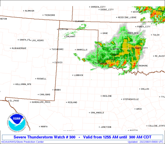
Severe Thunderstorm Watch Number 300
NWS Storm Prediction Center Norman OK
1255 AM CDT Wed Jun 1 2022
The NWS Storm Prediction Center has issued a
* Severe Thunderstorm Watch for portions of
Northwest Texas
* Effective this Wednesday morning from 1255 AM until 300 AM CDT.
* Primary threats include...
Scattered large hail and isolated very large hail events to 2.5
inches in diameter possible
SUMMARY...Elevated supercells embedded within a west/east-oriented
cluster should weaken this morning, but will pose a threat for
significant large hail until it does so.
The severe thunderstorm watch area is approximately along and 40
statute miles north and south of a line from 40 miles south
southeast of Childress TX to 80 miles west southwest of Childress
TX. For a complete depiction of the watch see the associated watch
outline update (WOUS64 KWNS WOU0).
PRECAUTIONARY/PREPAREDNESS ACTIONS...
REMEMBER...A Severe Thunderstorm Watch means conditions are
favorable for severe thunderstorms in and close to the watch area.
Persons in these areas should be on the lookout for threatening
weather conditions and listen for later statements and possible
warnings. Severe thunderstorms can and occasionally do produce
tornadoes.
&&
OTHER WATCH INFORMATION...CONTINUE...WW 298...WW 299...
AVIATION...A few severe thunderstorms with hail surface and aloft to
2.5 inches. Extreme turbulence and surface wind gusts to 50 knots. A
few cumulonimbi with maximum tops to 550. Mean storm motion vector
28030.
...Grams
   SEL0

   URGENT - IMMEDIATE BROADCAST REQUESTED
   Severe Thunderstorm Watch Number 300
   NWS Storm Prediction Center Norman OK
   1255 AM CDT Wed Jun 1 2022

   The NWS Storm Prediction Center has issued a

   * Severe Thunderstorm Watch for portions of
     Northwest Texas

   * Effective this Wednesday morning from 1255 AM until 300 AM CDT.

   * Primary threats include...
     Scattered large hail and isolated very large hail events to 2.5
       inches in diameter possible

   SUMMARY...Elevated supercells embedded within a west/east-oriented
   cluster should weaken this morning, but will pose a threat for
   significant large hail until it does so.

   The severe thunderstorm watch area is approximately along and 40
   statute miles north and south of a line from 40 miles south
   southeast of Childress TX to 80 miles west southwest of Childress
   TX. For a complete depiction of the watch see the associated watch
   outline update (WOUS64 KWNS WOU0).

   PRECAUTIONARY/PREPAREDNESS ACTIONS...

   REMEMBER...A Severe Thunderstorm Watch means conditions are
   favorable for severe thunderstorms in and close to the watch area.
   Persons in these areas should be on the lookout for threatening
   weather conditions and listen for later statements and possible
   warnings. Severe thunderstorms can and occasionally do produce
   tornadoes.

   &&

   OTHER WATCH INFORMATION...CONTINUE...WW 298...WW 299...

   AVIATION...A few severe thunderstorms with hail surface and aloft to
   2.5 inches. Extreme turbulence and surface wind gusts to 50 knots. A
   few cumulonimbi with maximum tops to 550. Mean storm motion vector
   28030.

   ...Grams
 Note:
The Aviation Watch (SAW) product is an approximation to the watch area.
The actual watch is depicted by the shaded areas.
Note:
The Aviation Watch (SAW) product is an approximation to the watch area.
The actual watch is depicted by the shaded areas.
SAW0
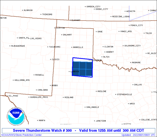
WW 300 SEVERE TSTM TX 010555Z - 010800Z
AXIS..40 STATUTE MILES NORTH AND SOUTH OF LINE..
40SSE CDS/CHILDRESS TX/ - 80WSW CDS/CHILDRESS TX/
..AVIATION COORDS.. 35NM N/S /31SSE CDS - 24NE LBB/
HAIL SURFACE AND ALOFT..2.5 INCHES. WIND GUSTS..50 KNOTS.
MAX TOPS TO 550. MEAN STORM MOTION VECTOR 28030.
LAT...LON 33320001 33400157 34560157 34470001
THIS IS AN APPROXIMATION TO THE WATCH AREA. FOR A
COMPLETE DEPICTION OF THE WATCH SEE WOUS64 KWNS
FOR WOU0.
Watch 300 Status Report Message has not been issued yet.
Note:
Click for Complete Product Text.
Tornadoes
Probability of 2 or more tornadoes
|
Low (<5%)
|
Probability of 1 or more strong (EF2-EF5) tornadoes
|
Low (<2%)
|
Wind
Probability of 10 or more severe wind events
|
Low (<5%)
|
Probability of 1 or more wind events > 65 knots
|
Low (<5%)
|
Hail
Probability of 10 or more severe hail events
|
Mod (40%)
|
Probability of 1 or more hailstones > 2 inches
|
Mod (40%)
|
Combined Severe Hail/Wind
Probability of 6 or more combined severe hail/wind events
|
Mod (50%)
|
For each watch, probabilities for particular events inside the watch
(listed above in each table) are determined by the issuing forecaster.
The "Low" category contains probability values ranging from less than 2%
to 20% (EF2-EF5 tornadoes), less than 5% to 20% (all other probabilities),
"Moderate" from 30% to 60%, and "High" from 70% to greater than 95%.
High values are bolded and lighter in color to provide awareness of
an increased threat for a particular event.


 @NWSSPC


