 Note:
The expiration time in the watch graphic is amended if the watch is
replaced, cancelled or extended.
Note:
Note:
The expiration time in the watch graphic is amended if the watch is
replaced, cancelled or extended.
Note: Click for
Watch Status Reports.
SEL2
URGENT - IMMEDIATE BROADCAST REQUESTED
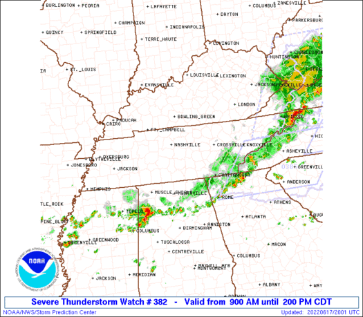
Severe Thunderstorm Watch Number 382
NWS Storm Prediction Center Norman OK
900 AM CDT Fri Jun 17 2022
The NWS Storm Prediction Center has issued a
* Severe Thunderstorm Watch for portions of
Middle and eastern Tennessee
* Effective this Friday morning and afternoon from 900 AM until
200 PM CDT.
* Primary threats include...
Scattered damaging wind gusts to 70 mph likely
Isolated large hail events to 1 inch in diameter possible
SUMMARY...MCS in southwest Kentucky will spread southeast across
portions of Tennessee through early afternoon.
The severe thunderstorm watch area is approximately along and 120
statute miles east and west of a line from 35 miles west of
Chattanooga TN to 40 miles northeast of Nashville TN. For a complete
depiction of the watch see the associated watch outline update
(WOUS64 KWNS WOU2).
PRECAUTIONARY/PREPAREDNESS ACTIONS...
REMEMBER...A Severe Thunderstorm Watch means conditions are
favorable for severe thunderstorms in and close to the watch area.
Persons in these areas should be on the lookout for threatening
weather conditions and listen for later statements and possible
warnings. Severe thunderstorms can and occasionally do produce
tornadoes.
&&
OTHER WATCH INFORMATION...CONTINUE...WW 381...
AVIATION...A few severe thunderstorms with hail surface and aloft to
1 inch. Extreme turbulence and surface wind gusts to 60 knots. A few
cumulonimbi with maximum tops to 500. Mean storm motion vector
32030.
...Grams
 Note:
The Aviation Watch (SAW) product is an approximation to the watch area.
The actual watch is depicted by the shaded areas.
Note:
The Aviation Watch (SAW) product is an approximation to the watch area.
The actual watch is depicted by the shaded areas.
SAW2
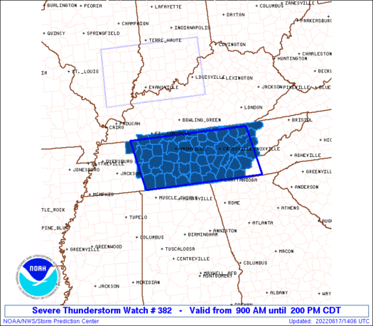
WW 382 SEVERE TSTM TN 171400Z - 171900Z
AXIS..120 STATUTE MILES EAST AND WEST OF LINE..
35W CHA/CHATTANOOGA TN/ - 40NE BNA/NASHVILLE TN/
..AVIATION COORDS.. 105NM E/W /33W GQO - 27SSE BWG/
HAIL SURFACE AND ALOFT..1 INCH. WIND GUSTS..60 KNOTS.
MAX TOPS TO 500. MEAN STORM MOTION VECTOR 32030.
LAT...LON 35008794 36528833 36528401 35008370
THIS IS AN APPROXIMATION TO THE WATCH AREA. FOR A
COMPLETE DEPICTION OF THE WATCH SEE WOUS64 KWNS
FOR WOU2.
Watch 382 Status Report Messages:
STATUS REPORT #4 ON WW 382

VALID 171830Z - 171900Z

SEVERE WEATHER THREAT CONTINUES RIGHT OF A LINE FROM 25 WSW CHA
TO 20 SSE CSV TO 25 NE TYS.

WW 382 WILL BE ALLOWED TO EXPIRE AT 171900Z.

..WEINMAN..06/17/22

ATTN...WFO...MRX...OHX...MEG...HUN...

&&

STATUS REPORT FOR WS 382

SEVERE WEATHER THREAT CONTINUES FOR THE FOLLOWING AREAS

TNC009-011-065-105-107-121-123-139-143-171900-

TN
.    TENNESSEE COUNTIES INCLUDED ARE

BLOUNT		     BRADLEY		 HAMILTON
LOUDON		     MCMINN		 MEIGS
MONROE		     POLK		 RHEA
$$


THE WATCH STATUS MESSAGE IS FOR GUIDANCE PURPOSES ONLY.  PLEASE
REFER TO WATCH COUNTY NOTIFICATION STATEMENTS FOR OFFICIAL
INFORMATION ON COUNTIES...INDEPENDENT CITIES AND MARINE ZONES
CLEARED FROM SEVERE THUNDERSTORM AND TORNADO WATCHES.
$$

STATUS REPORT #3 ON WW 382

VALID 171735Z - 171840Z

SEVERE WEATHER THREAT CONTINUES RIGHT OF A LINE FROM 35 ESE MKL
TO 50 SSE BNA TO 45 WSW CSV TO 50 SW LOZ.

..WEINMAN..06/17/22

ATTN...WFO...MRX...OHX...MEG...HUN...

&&

STATUS REPORT FOR WS 382

SEVERE WEATHER THREAT CONTINUES FOR THE FOLLOWING AREAS

TNC001-007-009-011-013-025-031-035-049-051-055-061-065-093-099-
103-105-107-115-121-123-127-129-139-143-145-151-153-173-175-181-
171840-

TN
.    TENNESSEE COUNTIES INCLUDED ARE

ANDERSON	     BLEDSOE		 BLOUNT
BRADLEY 	     CAMPBELL		 CLAIBORNE
COFFEE		     CUMBERLAND 	 FENTRESS
FRANKLIN	     GILES		 GRUNDY
HAMILTON	     KNOX		 LAWRENCE
LINCOLN 	     LOUDON		 MCMINN
MARION		     MEIGS		 MONROE
MOORE		     MORGAN		 POLK
RHEA		     ROANE		 SCOTT
SEQUATCHIE	     UNION		 VAN BUREN
WAYNE
$$


THE WATCH STATUS MESSAGE IS FOR GUIDANCE PURPOSES ONLY.  PLEASE
REFER TO WATCH COUNTY NOTIFICATION STATEMENTS FOR OFFICIAL
INFORMATION ON COUNTIES...INDEPENDENT CITIES AND MARINE ZONES
CLEARED FROM SEVERE THUNDERSTORM AND TORNADO WATCHES.
$$

STATUS REPORT #2 ON WW 382

VALID 171650Z - 171740Z

SEVERE WEATHER THREAT CONTINUES RIGHT OF A LINE FROM 30 E MKL TO
30 SSE BNA TO 50 N CSV.

FOR ADDITIONAL INFORMATION SEE MESOSCALE DISCUSSION 1205

..WEINMAN..06/17/22

ATTN...WFO...MRX...OHX...MEG...HUN...

&&

STATUS REPORT FOR WS 382

SEVERE WEATHER THREAT CONTINUES FOR THE FOLLOWING AREAS

TNC001-003-007-009-011-013-015-025-031-035-039-041-049-051-055-
061-065-093-099-101-103-105-107-115-117-119-121-123-127-129-133-
139-141-143-145-151-153-173-175-177-181-185-171740-

TN
.    TENNESSEE COUNTIES INCLUDED ARE

ANDERSON	     BEDFORD		 BLEDSOE
BLOUNT		     BRADLEY		 CAMPBELL
CANNON		     CLAIBORNE		 COFFEE
CUMBERLAND	     DECATUR		 DE KALB
FENTRESS	     FRANKLIN		 GILES
GRUNDY		     HAMILTON		 KNOX
LAWRENCE	     LEWIS		 LINCOLN
LOUDON		     MCMINN		 MARION
MARSHALL	     MAURY		 MEIGS
MONROE		     MOORE		 MORGAN
OVERTON 	     POLK		 PUTNAM
RHEA		     ROANE		 SCOTT
SEQUATCHIE	     UNION		 VAN BUREN
WARREN		     WAYNE		 WHITE
$$


THE WATCH STATUS MESSAGE IS FOR GUIDANCE PURPOSES ONLY.  PLEASE
REFER TO WATCH COUNTY NOTIFICATION STATEMENTS FOR OFFICIAL
INFORMATION ON COUNTIES...INDEPENDENT CITIES AND MARINE ZONES
CLEARED FROM SEVERE THUNDERSTORM AND TORNADO WATCHES.
$$

STATUS REPORT #1 ON WW 382

VALID 171540Z - 171640Z

SEVERE WEATHER THREAT CONTINUES RIGHT OF A LINE FROM 55 NE MKL TO
25 SSE CKV TO 15 NE BNA TO 25 NE BNA TO 25 SE BWG.

..BUNTING..06/17/22

ATTN...WFO...MRX...OHX...MEG...HUN...

&&

STATUS REPORT FOR WS 382

SEVERE WEATHER THREAT CONTINUES FOR THE FOLLOWING AREAS

TNC001-003-005-007-009-011-013-015-021-025-027-031-035-037-039-
041-043-049-051-055-061-065-081-083-085-087-093-099-101-103-105-
107-111-115-117-119-121-123-127-129-133-135-137-139-141-143-145-
149-151-153-159-169-173-175-177-181-185-187-189-171640-

TN
.    TENNESSEE COUNTIES INCLUDED ARE

ANDERSON	     BEDFORD		 BENTON
BLEDSOE 	     BLOUNT		 BRADLEY
CAMPBELL	     CANNON		 CHEATHAM
CLAIBORNE	     CLAY		 COFFEE
CUMBERLAND	     DAVIDSON		 DECATUR
DE KALB 	     DICKSON		 FENTRESS
FRANKLIN	     GILES		 GRUNDY
HAMILTON	     HICKMAN		 HOUSTON
HUMPHREYS	     JACKSON		 KNOX
LAWRENCE	     LEWIS		 LINCOLN
LOUDON		     MCMINN		 MACON
MARION		     MARSHALL		 MAURY
MEIGS		     MONROE		 MOORE
MORGAN		     OVERTON		 PERRY
PICKETT 	     POLK		 PUTNAM
RHEA		     ROANE		 RUTHERFORD
SCOTT		     SEQUATCHIE 	 SMITH
TROUSDALE	     UNION		 VAN BUREN
WARREN		     WAYNE		 WHITE
WILLIAMSON	     WILSON
$$


THE WATCH STATUS MESSAGE IS FOR GUIDANCE PURPOSES ONLY.  PLEASE
REFER TO WATCH COUNTY NOTIFICATION STATEMENTS FOR OFFICIAL
INFORMATION ON COUNTIES...INDEPENDENT CITIES AND MARINE ZONES
CLEARED FROM SEVERE THUNDERSTORM AND TORNADO WATCHES.
$$
Note:
Click for Complete Product Text.
Tornadoes
Probability of 2 or more tornadoes
|
Low (10%)
|
Probability of 1 or more strong (EF2-EF5) tornadoes
|
Low (<2%)
|
Wind
Probability of 10 or more severe wind events
|
Mod (60%)
|
Probability of 1 or more wind events > 65 knots
|
Low (20%)
|
Hail
Probability of 10 or more severe hail events
|
Low (20%)
|
Probability of 1 or more hailstones > 2 inches
|
Low (10%)
|
Combined Severe Hail/Wind
Probability of 6 or more combined severe hail/wind events
|
High (80%)
|
For each watch, probabilities for particular events inside the watch
(listed above in each table) are determined by the issuing forecaster.
The "Low" category contains probability values ranging from less than 2%
to 20% (EF2-EF5 tornadoes), less than 5% to 20% (all other probabilities),
"Moderate" from 30% to 60%, and "High" from 70% to greater than 95%.
High values are bolded and lighter in color to provide awareness of
an increased threat for a particular event.


 @NWSSPC


