Note:
The expiration time in the watch graphic is amended if the watch is
replaced, cancelled or extended.
Note:
Note:
The expiration time in the watch graphic is amended if the watch is
replaced, cancelled or extended.
Note: Click for
Watch Status Reports.
SEL2
URGENT - IMMEDIATE BROADCAST REQUESTED
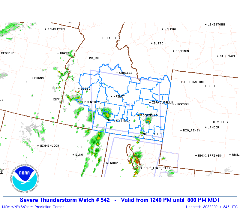
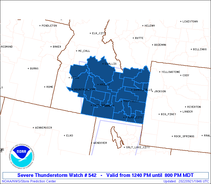
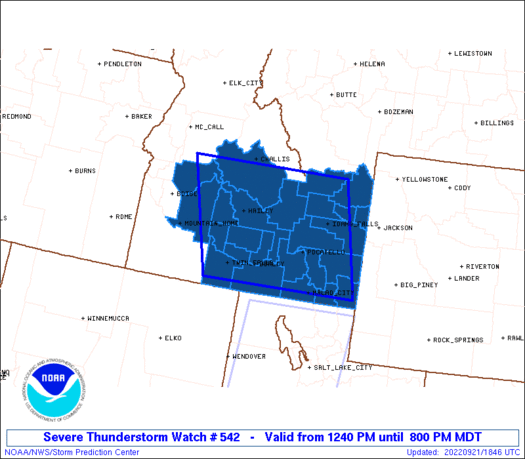
Severe Thunderstorm Watch Number 542
NWS Storm Prediction Center Norman OK
1240 PM MDT Wed Sep 21 2022
The NWS Storm Prediction Center has issued a
* Severe Thunderstorm Watch for portions of
Southern Idaho
* Effective this Wednesday afternoon and evening from 1240 PM
until 800 PM MDT.
* Primary threats include...
Scattered damaging winds and isolated significant gusts to 75
mph possible
Isolated large hail events to 1 inch in diameter possible
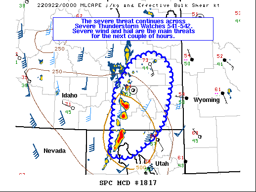
SUMMARY...Multiple rounds of scattered thunderstorm development are
expected into this evening with primary threats of severe wind gusts
and marginally severe hail.
The severe thunderstorm watch area is approximately along and 100
statute miles east and west of a line from 70 miles north northeast
of Hailey ID to 40 miles west of Malad City ID. For a complete
depiction of the watch see the associated watch outline update
(WOUS64 KWNS WOU2).
PRECAUTIONARY/PREPAREDNESS ACTIONS...
REMEMBER...A Severe Thunderstorm Watch means conditions are
favorable for severe thunderstorms in and close to the watch area.
Persons in these areas should be on the lookout for threatening
weather conditions and listen for later statements and possible
warnings. Severe thunderstorms can and occasionally do produce
tornadoes.
&&
OTHER WATCH INFORMATION...CONTINUE...WW 541...
AVIATION...A few severe thunderstorms with hail surface and aloft to
1 inch. Extreme turbulence and surface wind gusts to 65 knots. A few
cumulonimbi with maximum tops to 350. Mean storm motion vector
19030.
...Grams
 Note:
The Aviation Watch (SAW) product is an approximation to the watch area.
The actual watch is depicted by the shaded areas.
Note:
The Aviation Watch (SAW) product is an approximation to the watch area.
The actual watch is depicted by the shaded areas.
   SAW2
   WW 542 SEVERE TSTM ID 211840Z - 220200Z
   AXIS..100 STATUTE MILES EAST AND WEST OF LINE..
   70NNE SUN/HAILEY ID/ - 40W MLD/MALAD CITY ID/
   ..AVIATION COORDS.. 85NM E/W /38SSE LKT - 28W MLD/
   HAIL SURFACE AND ALOFT..1 INCH. WIND GUSTS..65 KNOTS.
   MAX TOPS TO 350. MEAN STORM MOTION VECTOR 19030.

   LAT...LON 44421173 42151113 42151503 44421578

   THIS IS AN APPROXIMATION TO THE WATCH AREA.  FOR A
   COMPLETE DEPICTION OF THE WATCH SEE WOUS64 KWNS
   FOR WOU2.
Watch 542 Status Report Messages:
STATUS REPORT #4 ON WW 542

VALID 220035Z - 220140Z

SEVERE WEATHER THREAT CONTINUES RIGHT OF A LINE FROM 40 SE BYI TO
45 SE SMN.

..SQUITIERI..09/22/22

ATTN...WFO...PIH...BOI...

&&

STATUS REPORT FOR WS 542

SEVERE WEATHER THREAT CONTINUES FOR THE FOLLOWING AREAS

IDC005-007-011-019-023-029-033-041-043-051-065-071-077-081-
220140-

ID
.    IDAHO COUNTIES INCLUDED ARE

BANNOCK 	     BEAR LAKE		 BINGHAM
BONNEVILLE	     BUTTE		 CARIBOU
CLARK		     FRANKLIN		 FREMONT
JEFFERSON	     MADISON		 ONEIDA
POWER		     TETON
$$


THE WATCH STATUS MESSAGE IS FOR GUIDANCE PURPOSES ONLY.  PLEASE
REFER TO WATCH COUNTY NOTIFICATION STATEMENTS FOR OFFICIAL
INFORMATION ON COUNTIES...INDEPENDENT CITIES AND MARINE ZONES
CLEARED FROM SEVERE THUNDERSTORM AND TORNADO WATCHES.
$$

STATUS REPORT #3 ON WW 542

VALID 212315Z - 220040Z

SEVERE WEATHER THREAT CONTINUES RIGHT OF A LINE FROM 35 S BYI TO
30 NE SUN TO 35 SSW SMN.

..SQUITIERI..09/21/22

ATTN...WFO...PIH...BOI...

&&

STATUS REPORT FOR WS 542

SEVERE WEATHER THREAT CONTINUES FOR THE FOLLOWING AREAS

IDC005-007-011-019-023-029-031-033-041-043-051-065-067-071-077-
081-220040-

ID
.    IDAHO COUNTIES INCLUDED ARE

BANNOCK 	     BEAR LAKE		 BINGHAM
BONNEVILLE	     BUTTE		 CARIBOU
CASSIA		     CLARK		 FRANKLIN
FREMONT 	     JEFFERSON		 MADISON
MINIDOKA	     ONEIDA		 POWER
TETON
$$


THE WATCH STATUS MESSAGE IS FOR GUIDANCE PURPOSES ONLY.  PLEASE
REFER TO WATCH COUNTY NOTIFICATION STATEMENTS FOR OFFICIAL
INFORMATION ON COUNTIES...INDEPENDENT CITIES AND MARINE ZONES
CLEARED FROM SEVERE THUNDERSTORM AND TORNADO WATCHES.
$$

STATUS REPORT #2 ON WW 542

VALID 212150Z - 212240Z

THE SEVERE WEATHER THREAT CONTINUES ACROSS THE ENTIRE WATCH AREA.

..SQUITIERI..09/21/22

ATTN...WFO...PIH...BOI...

&&

STATUS REPORT FOR WS 542

SEVERE WEATHER THREAT CONTINUES FOR THE FOLLOWING AREAS

IDC005-007-011-013-015-019-023-025-029-031-033-037-039-041-043-
047-051-053-063-065-067-071-077-081-083-212240-

ID
.    IDAHO COUNTIES INCLUDED ARE

BANNOCK 	     BEAR LAKE		 BINGHAM
BLAINE		     BOISE		 BONNEVILLE
BUTTE		     CAMAS		 CARIBOU
CASSIA		     CLARK		 CUSTER
ELMORE		     FRANKLIN		 FREMONT
GOODING 	     JEFFERSON		 JEROME
LINCOLN 	     MADISON		 MINIDOKA
ONEIDA		     POWER		 TETON
TWIN FALLS
$$


THE WATCH STATUS MESSAGE IS FOR GUIDANCE PURPOSES ONLY.  PLEASE
REFER TO WATCH COUNTY NOTIFICATION STATEMENTS FOR OFFICIAL
INFORMATION ON COUNTIES...INDEPENDENT CITIES AND MARINE ZONES
CLEARED FROM SEVERE THUNDERSTORM AND TORNADO WATCHES.
$$

STATUS REPORT #1 ON WW 542

VALID 212020Z - 212140Z

THE SEVERE WEATHER THREAT CONTINUES ACROSS THE ENTIRE WATCH AREA.

..LYONS..09/21/22

ATTN...WFO...PIH...BOI...

&&

STATUS REPORT FOR WS 542

SEVERE WEATHER THREAT CONTINUES FOR THE FOLLOWING AREAS

IDC005-007-011-013-015-019-023-025-029-031-033-037-039-041-043-
047-051-053-063-065-067-071-077-081-083-212140-

ID
.    IDAHO COUNTIES INCLUDED ARE

BANNOCK 	     BEAR LAKE		 BINGHAM
BLAINE		     BOISE		 BONNEVILLE
BUTTE		     CAMAS		 CARIBOU
CASSIA		     CLARK		 CUSTER
ELMORE		     FRANKLIN		 FREMONT
GOODING 	     JEFFERSON		 JEROME
LINCOLN 	     MADISON		 MINIDOKA
ONEIDA		     POWER		 TETON
TWIN FALLS
$$


THE WATCH STATUS MESSAGE IS FOR GUIDANCE PURPOSES ONLY.  PLEASE
REFER TO WATCH COUNTY NOTIFICATION STATEMENTS FOR OFFICIAL
INFORMATION ON COUNTIES...INDEPENDENT CITIES AND MARINE ZONES
CLEARED FROM SEVERE THUNDERSTORM AND TORNADO WATCHES.
$$
Note:
Click for Complete Product Text.
Tornadoes
Probability of 2 or more tornadoes
|
Low (<5%)
|
Probability of 1 or more strong (EF2-EF5) tornadoes
|
Low (<2%)
|
Wind
Probability of 10 or more severe wind events
|
Mod (40%)
|
Probability of 1 or more wind events > 65 knots
|
Mod (30%)
|
Hail
Probability of 10 or more severe hail events
|
Low (20%)
|
Probability of 1 or more hailstones > 2 inches
|
Low (10%)
|
Combined Severe Hail/Wind
Probability of 6 or more combined severe hail/wind events
|
Mod (60%)
|
For each watch, probabilities for particular events inside the watch
(listed above in each table) are determined by the issuing forecaster.
The "Low" category contains probability values ranging from less than 2%
to 20% (EF2-EF5 tornadoes), less than 5% to 20% (all other probabilities),
"Moderate" from 30% to 60%, and "High" from 70% to greater than 95%.
High values are bolded and lighter in color to provide awareness of
an increased threat for a particular event.


 @NWSSPC