 Note:
The expiration time in the watch graphic is amended if the watch is
replaced, cancelled or extended.
Note:
Note:
The expiration time in the watch graphic is amended if the watch is
replaced, cancelled or extended.
Note: Click for
Watch Status Reports.
SEL2
URGENT - IMMEDIATE BROADCAST REQUESTED
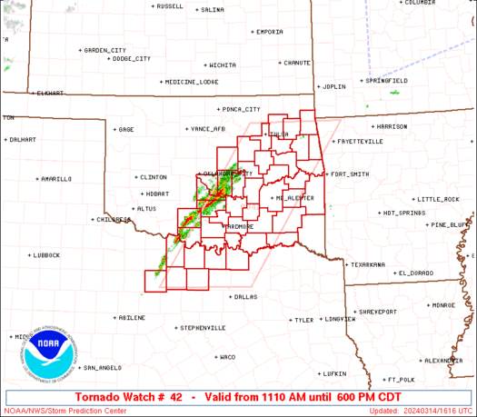
Tornado Watch Number 42
NWS Storm Prediction Center Norman OK
1110 AM CDT Thu Mar 14 2024
The NWS Storm Prediction Center has issued a
* Tornado Watch for portions of
Central/eastern Oklahoma
North-central Texas
* Effective this Thursday morning and evening from 1110 AM until
600 PM CDT.
* Primary threats include...
A few tornadoes and a couple intense tornadoes possible
Widespread large hail and scattered very large hail events to 3
inches in diameter likely
Scattered damaging wind gusts to 70 mph possible
SUMMARY...Supercell thunderstorms will continue to increase in
coverage and intensity through the afternoon, while posing a threat
for very large hail, severe/damaging winds, and a few tornadoes.
The tornado watch area is approximately along and 65 statute miles
east and west of a line from 45 miles east northeast of Tulsa OK to
65 miles southwest of Sherman TX. For a complete depiction of the
watch see the associated watch outline update (WOUS64 KWNS WOU2).
PRECAUTIONARY/PREPAREDNESS ACTIONS...
REMEMBER...A Tornado Watch means conditions are favorable for
tornadoes and severe thunderstorms in and close to the watch
area. Persons in these areas should be on the lookout for
threatening weather conditions and listen for later statements
and possible warnings.
&&
OTHER WATCH INFORMATION...CONTINUE...WW 40...WW 41...
AVIATION...Tornadoes and a few severe thunderstorms with hail
surface and aloft to 3 inches. Extreme turbulence and surface wind
gusts to 60 knots. A few cumulonimbi with maximum tops to 450. Mean
storm motion vector 24035.
...Gleason/Goss
   SEL2

   URGENT - IMMEDIATE BROADCAST REQUESTED
   Tornado Watch Number 42
   NWS Storm Prediction Center Norman OK
   1110 AM CDT Thu Mar 14 2024

   The NWS Storm Prediction Center has issued a

   * Tornado Watch for portions of
     Central/eastern Oklahoma
     North-central Texas

   * Effective this Thursday morning and evening from 1110 AM until
     600 PM CDT.

   * Primary threats include...
     A few tornadoes and a couple intense tornadoes possible
     Widespread large hail and scattered very large hail events to 3
       inches in diameter likely
     Scattered damaging wind gusts to 70 mph possible

   SUMMARY...Supercell thunderstorms will continue to increase in
   coverage and intensity through the afternoon, while posing a threat
   for very large hail, severe/damaging winds, and a few tornadoes.

   The tornado watch area is approximately along and 65 statute miles
   east and west of a line from 45 miles east northeast of Tulsa OK to
   65 miles southwest of Sherman TX. For a complete depiction of the
   watch see the associated watch outline update (WOUS64 KWNS WOU2).

   PRECAUTIONARY/PREPAREDNESS ACTIONS...

   REMEMBER...A Tornado Watch means conditions are favorable for
   tornadoes and severe thunderstorms in and close to the watch
   area. Persons in these areas should be on the lookout for
   threatening weather conditions and listen for later statements
   and possible warnings.

   &&

   OTHER WATCH INFORMATION...CONTINUE...WW 40...WW 41...

   AVIATION...Tornadoes and a few severe thunderstorms with hail
   surface and aloft to 3 inches. Extreme turbulence and surface wind
   gusts to 60 knots. A few cumulonimbi with maximum tops to 450. Mean
   storm motion vector 24035.

   ...Gleason/Goss
 Note:
The Aviation Watch (SAW) product is an approximation to the watch area.
The actual watch is depicted by the shaded areas.
Note:
The Aviation Watch (SAW) product is an approximation to the watch area.
The actual watch is depicted by the shaded areas.
SAW2
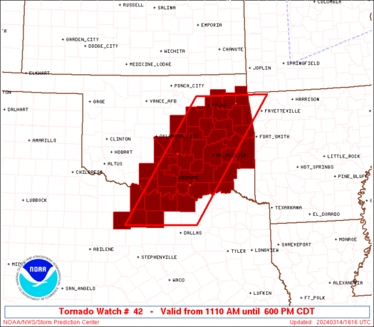
WW 42 TORNADO OK TX 141610Z - 142300Z
AXIS..65 STATUTE MILES EAST AND WEST OF LINE..
45ENE TUL/TULSA OK/ - 65SW GYI/SHERMAN TX/
..AVIATION COORDS.. 55NM E/W /35ENE TUL - 24WNW TTT/
HAIL SURFACE AND ALOFT..3 INCHES. WIND GUSTS..60 KNOTS.
MAX TOPS TO 450. MEAN STORM MOTION VECTOR 24035.
LAT...LON 36439396 33059634 33059859 36439630
THIS IS AN APPROXIMATION TO THE WATCH AREA. FOR A
COMPLETE DEPICTION OF THE WATCH SEE WOUS64 KWNS
FOR WOU2.
Watch 42 Status Report Messages:
STATUS REPORT #4 ON WW 42

VALID 142035Z - 142140Z

SEVERE WEATHER THREAT CONTINUES RIGHT OF A LINE FROM 25 ESE SPS
TO 35 W ADM TO 30 SSW CQB TO 15 SSW BVO.

..SQUITIERI..03/14/24

ATTN...WFO...TSA...OUN...FWD...

&&

STATUS REPORT FOR WT 42

SEVERE WEATHER THREAT CONTINUES FOR THE FOLLOWING AREAS

OKC001-005-013-019-021-023-029-035-037-041-049-061-063-067-069-
077-079-085-091-095-097-099-101-107-111-115-121-123-125-127-131-
133-135-143-145-142140-

OK
.    OKLAHOMA COUNTIES INCLUDED ARE

ADAIR		     ATOKA		 BRYAN
CARTER		     CHEROKEE		 CHOCTAW
COAL		     CRAIG		 CREEK
DELAWARE	     GARVIN		 HASKELL
HUGHES		     JEFFERSON		 JOHNSTON
LATIMER 	     LE FLORE		 LOVE
MCINTOSH	     MARSHALL		 MAYES
MURRAY		     MUSKOGEE		 OKFUSKEE
OKMULGEE	     OTTAWA		 PITTSBURG
PONTOTOC	     POTTAWATOMIE	 PUSHMATAHA
ROGERS		     SEMINOLE		 SEQUOYAH
TULSA		     WAGONER
$$


TXC097-181-237-337-497-142140-

TX
.    TEXAS COUNTIES INCLUDED ARE

COOKE		     GRAYSON		 JACK
MONTAGUE	     WISE
$$


THE WATCH STATUS MESSAGE IS FOR GUIDANCE PURPOSES ONLY.  PLEASE
REFER TO WATCH COUNTY NOTIFICATION STATEMENTS FOR OFFICIAL
INFORMATION ON COUNTIES...INDEPENDENT CITIES AND MARINE ZONES
CLEARED FROM SEVERE THUNDERSTORM AND TORNADO WATCHES.
$$

STATUS REPORT #3 ON WW 42

VALID 141940Z - 142040Z

THE SEVERE WEATHER THREAT CONTINUES ACROSS THE ENTIRE WATCH AREA.

..SQUITIERI..03/14/24

ATTN...WFO...TSA...OUN...FWD...

&&

STATUS REPORT FOR WT 42

SEVERE WEATHER THREAT CONTINUES FOR THE FOLLOWING AREAS

OKC001-005-013-019-021-023-029-037-041-049-061-063-067-069-077-
079-081-085-087-091-095-097-099-101-107-111-121-123-125-127-131-
133-135-137-143-145-142040-

OK
.    OKLAHOMA COUNTIES INCLUDED ARE

ADAIR		     ATOKA		 BRYAN
CARTER		     CHEROKEE		 CHOCTAW
COAL		     CREEK		 DELAWARE
GARVIN		     HASKELL		 HUGHES
JEFFERSON	     JOHNSTON		 LATIMER
LE FLORE	     LINCOLN		 LOVE
MCCLAIN 	     MCINTOSH		 MARSHALL
MAYES		     MURRAY		 MUSKOGEE
OKFUSKEE	     OKMULGEE		 PITTSBURG
PONTOTOC	     POTTAWATOMIE	 PUSHMATAHA
ROGERS		     SEMINOLE		 SEQUOYAH
STEPHENS	     TULSA		 WAGONER
$$


TXC077-097-181-237-337-497-503-142040-

TX
.    TEXAS COUNTIES INCLUDED ARE

CLAY		     COOKE		 GRAYSON
JACK		     MONTAGUE		 WISE
YOUNG
$$


THE WATCH STATUS MESSAGE IS FOR GUIDANCE PURPOSES ONLY.  PLEASE
REFER TO WATCH COUNTY NOTIFICATION STATEMENTS FOR OFFICIAL
INFORMATION ON COUNTIES...INDEPENDENT CITIES AND MARINE ZONES
CLEARED FROM SEVERE THUNDERSTORM AND TORNADO WATCHES.
$$

STATUS REPORT #2 ON WW 42

VALID 141855Z - 141940Z

THE SEVERE WEATHER THREAT CONTINUES ACROSS THE ENTIRE WATCH AREA.

..SQUITIERI..03/14/24

ATTN...WFO...TSA...OUN...FWD...

&&

STATUS REPORT FOR WT 42

SEVERE WEATHER THREAT CONTINUES FOR THE FOLLOWING AREAS

OKC001-005-013-019-021-023-029-037-041-049-061-063-067-069-077-
079-081-085-087-091-095-097-099-101-107-111-121-123-125-127-131-
133-135-137-143-145-141940-

OK
.    OKLAHOMA COUNTIES INCLUDED ARE

ADAIR		     ATOKA		 BRYAN
CARTER		     CHEROKEE		 CHOCTAW
COAL		     CREEK		 DELAWARE
GARVIN		     HASKELL		 HUGHES
JEFFERSON	     JOHNSTON		 LATIMER
LE FLORE	     LINCOLN		 LOVE
MCCLAIN 	     MCINTOSH		 MARSHALL
MAYES		     MURRAY		 MUSKOGEE
OKFUSKEE	     OKMULGEE		 PITTSBURG
PONTOTOC	     POTTAWATOMIE	 PUSHMATAHA
ROGERS		     SEMINOLE		 SEQUOYAH
STEPHENS	     TULSA		 WAGONER
$$


TXC077-097-181-237-337-497-503-141940-

TX
.    TEXAS COUNTIES INCLUDED ARE

CLAY		     COOKE		 GRAYSON
JACK		     MONTAGUE		 WISE
YOUNG
$$


THE WATCH STATUS MESSAGE IS FOR GUIDANCE PURPOSES ONLY.  PLEASE
REFER TO WATCH COUNTY NOTIFICATION STATEMENTS FOR OFFICIAL
INFORMATION ON COUNTIES...INDEPENDENT CITIES AND MARINE ZONES
CLEARED FROM SEVERE THUNDERSTORM AND TORNADO WATCHES.
$$

STATUS REPORT #1 ON WW 42

VALID 141625Z - 141740Z

THE SEVERE WEATHER THREAT CONTINUES ACROSS THE ENTIRE WATCH AREA.

..LYONS..03/14/24

ATTN...WFO...TSA...OUN...FWD...

&&

STATUS REPORT FOR WT 42

SEVERE WEATHER THREAT CONTINUES FOR THE FOLLOWING AREAS

OKC001-005-013-019-021-023-027-029-037-041-049-061-063-067-069-
077-079-081-085-087-091-095-097-099-101-107-111-121-123-125-127-
131-133-135-137-143-145-141740-

OK
.    OKLAHOMA COUNTIES INCLUDED ARE

ADAIR		     ATOKA		 BRYAN
CARTER		     CHEROKEE		 CHOCTAW
CLEVELAND	     COAL		 CREEK
DELAWARE	     GARVIN		 HASKELL
HUGHES		     JEFFERSON		 JOHNSTON
LATIMER 	     LE FLORE		 LINCOLN
LOVE		     MCCLAIN		 MCINTOSH
MARSHALL	     MAYES		 MURRAY
MUSKOGEE	     OKFUSKEE		 OKMULGEE
PITTSBURG	     PONTOTOC		 POTTAWATOMIE
PUSHMATAHA	     ROGERS		 SEMINOLE
SEQUOYAH	     STEPHENS		 TULSA
WAGONER
$$


TXC077-097-181-237-337-497-503-141740-

TX
.    TEXAS COUNTIES INCLUDED ARE

CLAY		     COOKE		 GRAYSON
JACK		     MONTAGUE		 WISE
YOUNG
$$


THE WATCH STATUS MESSAGE IS FOR GUIDANCE PURPOSES ONLY.  PLEASE
REFER TO WATCH COUNTY NOTIFICATION STATEMENTS FOR OFFICIAL
INFORMATION ON COUNTIES...INDEPENDENT CITIES AND MARINE ZONES
CLEARED FROM SEVERE THUNDERSTORM AND TORNADO WATCHES.
$$
Note:
Click for Complete Product Text.
Tornadoes
Probability of 2 or more tornadoes
|
Mod (50%)
|
Probability of 1 or more strong (EF2-EF5) tornadoes
|
Mod (30%)
|
Wind
Probability of 10 or more severe wind events
|
Mod (50%)
|
Probability of 1 or more wind events > 65 knots
|
Low (20%)
|
Hail
Probability of 10 or more severe hail events
|
High (80%)
|
Probability of 1 or more hailstones > 2 inches
|
High (80%)
|
Combined Severe Hail/Wind
Probability of 6 or more combined severe hail/wind events
|
High (>95%)
|
For each watch, probabilities for particular events inside the watch
(listed above in each table) are determined by the issuing forecaster.
The "Low" category contains probability values ranging from less than 2%
to 20% (EF2-EF5 tornadoes), less than 5% to 20% (all other probabilities),
"Moderate" from 30% to 60%, and "High" from 70% to greater than 95%.
High values are bolded and lighter in color to provide awareness of
an increased threat for a particular event.


 @NWSSPC


