 Note:
The expiration time in the watch graphic is amended if the watch is
replaced, cancelled or extended.
Note:
Note:
The expiration time in the watch graphic is amended if the watch is
replaced, cancelled or extended.
Note: Click for
Watch Status Reports.
SEL7
URGENT - IMMEDIATE BROADCAST REQUESTED
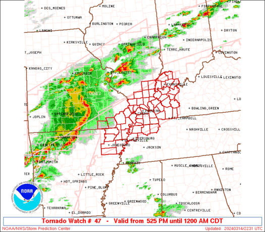
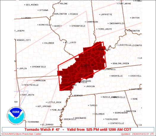
Tornado Watch Number 47
NWS Storm Prediction Center Norman OK
525 PM CDT Thu Mar 14 2024
The NWS Storm Prediction Center has issued a
* Tornado Watch for portions of
Northeast Arkansas
Southern Illinois
Southwest Indiana
Western Kentucky
Southeast Missouri
Northwest Tennessee
* Effective this Thursday afternoon from 525 PM until Midnight
CDT.
* Primary threats include...
A couple tornadoes possible
Scattered damaging winds likely with isolated significant gusts
to 80 mph possible
Scattered large hail and isolated very large hail events to 2
inches in diameter possible
SUMMARY...A fast-moving line of thunderstorms over southern Missouri
will track eastward through the late afternoon and evening, posing a
risk of damaging winds gusts and hail. A few tornadoes are also
possible.
The tornado watch area is approximately along and 60 statute miles
north and south of a line from 15 miles north northwest of Walnut
Ridge AR to 15 miles east southeast of Owensboro KY. For a complete
depiction of the watch see the associated watch outline update
(WOUS64 KWNS WOU7).
PRECAUTIONARY/PREPAREDNESS ACTIONS...
REMEMBER...A Tornado Watch means conditions are favorable for
tornadoes and severe thunderstorms in and close to the watch
area. Persons in these areas should be on the lookout for
threatening weather conditions and listen for later statements
and possible warnings.
&&
OTHER WATCH INFORMATION...CONTINUE...WW 42...WW 43...WW 44...WW
45...WW 46...
AVIATION...Tornadoes and a few severe thunderstorms with hail
surface and aloft to 2 inches. Extreme turbulence and surface wind
gusts to 70 knots. A few cumulonimbi with maximum tops to 500. Mean
storm motion vector 26040.
...Hart
   SEL7

   URGENT - IMMEDIATE BROADCAST REQUESTED
   Tornado Watch Number 47
   NWS Storm Prediction Center Norman OK
   525 PM CDT Thu Mar 14 2024

   The NWS Storm Prediction Center has issued a

   * Tornado Watch for portions of
     Northeast Arkansas
     Southern Illinois
     Southwest Indiana
     Western Kentucky
     Southeast Missouri
     Northwest Tennessee

   * Effective this Thursday afternoon from 525 PM until Midnight
     CDT.

   * Primary threats include...
     A couple tornadoes possible
     Scattered damaging winds likely with isolated significant gusts
       to 80 mph possible
     Scattered large hail and isolated very large hail events to 2
       inches in diameter possible

   SUMMARY...A fast-moving line of thunderstorms over southern Missouri
   will track eastward through the late afternoon and evening, posing a
   risk of damaging winds gusts and hail.  A few tornadoes are also
   possible.

   The tornado watch area is approximately along and 60 statute miles
   north and south of a line from 15 miles north northwest of Walnut
   Ridge AR to 15 miles east southeast of Owensboro KY. For a complete
   depiction of the watch see the associated watch outline update
   (WOUS64 KWNS WOU7).

   PRECAUTIONARY/PREPAREDNESS ACTIONS...

   REMEMBER...A Tornado Watch means conditions are favorable for
   tornadoes and severe thunderstorms in and close to the watch
   area. Persons in these areas should be on the lookout for
   threatening weather conditions and listen for later statements
   and possible warnings.

   &&

   OTHER WATCH INFORMATION...CONTINUE...WW 42...WW 43...WW 44...WW
   45...WW 46...

   AVIATION...Tornadoes and a few severe thunderstorms with hail
   surface and aloft to 2 inches. Extreme turbulence and surface wind
   gusts to 70 knots. A few cumulonimbi with maximum tops to 500. Mean
   storm motion vector 26040.

   ...Hart
 Note:
The Aviation Watch (SAW) product is an approximation to the watch area.
The actual watch is depicted by the shaded areas.
Note:
The Aviation Watch (SAW) product is an approximation to the watch area.
The actual watch is depicted by the shaded areas.
   SAW7
   WW 47 TORNADO AR IL IN KY MO TN 142225Z - 150500Z
   AXIS..60 STATUTE MILES NORTH AND SOUTH OF LINE..
   15NNW ARG/WALNUT RIDGE AR/ - 15ESE OWB/OWENSBORO KY/
   ..AVIATION COORDS.. 50NM N/S /14NNW ARG - 44ESE PXV/
   HAIL SURFACE AND ALOFT..2 INCHES. WIND GUSTS..70 KNOTS.
   MAX TOPS TO 500. MEAN STORM MOTION VECTOR 26040.

   LAT...LON 37209103 38508692 36778692 35469103

   THIS IS AN APPROXIMATION TO THE WATCH AREA.  FOR A
   COMPLETE DEPICTION OF THE WATCH SEE WOUS64 KWNS
   FOR WOU7.
Watch 47 Status Report Messages:
STATUS REPORT #5 ON WW 47

VALID 150305Z - 150440Z

SEVERE WEATHER THREAT CONTINUES RIGHT OF A LINE FROM 25 SSW ARG
TO 40 NNW DYR TO 45 NE PAH TO 35 NNE EVV.

..BROYLES..03/15/24

ATTN...WFO...MEG...PAH...

&&

STATUS REPORT FOR WT 47

SEVERE WEATHER THREAT CONTINUES FOR THE FOLLOWING AREAS

ARC031-093-111-150440-

AR
.    ARKANSAS COUNTIES INCLUDED ARE

CRAIGHEAD	     MISSISSIPPI	 POINSETT
$$


INC051-125-147-163-173-150440-

IN
.    INDIANA COUNTIES INCLUDED ARE

GIBSON		     PIKE		 SPENCER
VANDERBURGH	     WARRICK
$$


KYC033-035-047-055-059-101-107-139-143-149-157-177-219-221-225-
233-150440-

KY
.    KENTUCKY COUNTIES INCLUDED ARE

CALDWELL	     CALLOWAY		 CHRISTIAN
CRITTENDEN	     DAVIESS		 HENDERSON
HOPKINS 	     LIVINGSTON 	 LYON
MCLEAN		     MARSHALL		 MUHLENBERG
TODD		     TRIGG		 UNION
WEBSTER
$$


MOC155-150440-

MO
.    MISSOURI COUNTIES INCLUDED ARE

PEMISCOT
$$


TNC045-079-095-131-183-150440-

TN
.    TENNESSEE COUNTIES INCLUDED ARE

DYER		     HENRY		 LAKE
OBION		     WEAKLEY
$$


THE WATCH STATUS MESSAGE IS FOR GUIDANCE PURPOSES ONLY.  PLEASE
REFER TO WATCH COUNTY NOTIFICATION STATEMENTS FOR OFFICIAL
INFORMATION ON COUNTIES...INDEPENDENT CITIES AND MARINE ZONES
CLEARED FROM SEVERE THUNDERSTORM AND TORNADO WATCHES.
$$

STATUS REPORT #4 ON WW 47

VALID 150135Z - 150240Z

SEVERE WEATHER THREAT CONTINUES RIGHT OF A LINE FROM 25 SSW ARG
TO 35 ESE POF TO 20 NE MDH.

..SQUITIERI..03/15/24

ATTN...WFO...MEG...PAH...

&&

STATUS REPORT FOR WT 47

SEVERE WEATHER THREAT CONTINUES FOR THE FOLLOWING AREAS

ARC021-031-055-093-111-150240-

AR
.    ARKANSAS COUNTIES INCLUDED ARE

CLAY		     CRAIGHEAD		 GREENE
MISSISSIPPI	     POINSETT
$$


ILC059-065-069-087-127-151-153-165-193-150240-

IL
.    ILLINOIS COUNTIES INCLUDED ARE

GALLATIN	     HAMILTON		 HARDIN
JOHNSON 	     MASSAC		 POPE
PULASKI 	     SALINE		 WHITE
$$


INC051-125-129-147-163-173-150240-

IN
.    INDIANA COUNTIES INCLUDED ARE

GIBSON		     PIKE		 POSEY
SPENCER 	     VANDERBURGH	 WARRICK
$$


KYC007-033-035-039-047-055-059-075-083-101-105-107-139-143-145-
149-157-177-219-221-225-233-150240-

KY
.    KENTUCKY COUNTIES INCLUDED ARE

BALLARD 	     CALDWELL		 CALLOWAY
CARLISLE	     CHRISTIAN		 CRITTENDEN
DAVIESS 	     FULTON		 GRAVES
HENDERSON	     HICKMAN		 HOPKINS
LIVINGSTON	     LYON		 MCCRACKEN
MCLEAN		     MARSHALL		 MUHLENBERG
TODD		     TRIGG		 UNION
WEBSTER
$$


MOC069-133-143-155-150240-

MO
.    MISSOURI COUNTIES INCLUDED ARE

DUNKLIN 	     MISSISSIPPI	 NEW MADRID
PEMISCOT
$$


TNC045-079-095-131-183-150240-

TN
.    TENNESSEE COUNTIES INCLUDED ARE

DYER		     HENRY		 LAKE
OBION		     WEAKLEY
$$


THE WATCH STATUS MESSAGE IS FOR GUIDANCE PURPOSES ONLY.  PLEASE
REFER TO WATCH COUNTY NOTIFICATION STATEMENTS FOR OFFICIAL
INFORMATION ON COUNTIES...INDEPENDENT CITIES AND MARINE ZONES
CLEARED FROM SEVERE THUNDERSTORM AND TORNADO WATCHES.
$$

STATUS REPORT #3 ON WW 47

VALID 150015Z - 150140Z

SEVERE WEATHER THREAT CONTINUES RIGHT OF A LINE FROM 25 NNW ARG
TO 25 S FAM.

..SQUITIERI..03/15/24

ATTN...WFO...MEG...PAH...

&&

STATUS REPORT FOR WT 47

SEVERE WEATHER THREAT CONTINUES FOR THE FOLLOWING AREAS

ARC021-031-055-093-111-150140-

AR
.    ARKANSAS COUNTIES INCLUDED ARE

CLAY		     CRAIGHEAD		 GREENE
MISSISSIPPI	     POINSETT
$$


ILC003-059-065-069-087-127-151-153-165-181-193-199-150140-

IL
.    ILLINOIS COUNTIES INCLUDED ARE

ALEXANDER	     GALLATIN		 HAMILTON
HARDIN		     JOHNSON		 MASSAC
POPE		     PULASKI		 SALINE
UNION		     WHITE		 WILLIAMSON
$$


INC051-125-129-147-163-173-150140-

IN
.    INDIANA COUNTIES INCLUDED ARE

GIBSON		     PIKE		 POSEY
SPENCER 	     VANDERBURGH	 WARRICK
$$


KYC007-033-035-039-047-055-059-075-083-101-105-107-139-143-145-
149-157-177-219-221-225-233-150140-

KY
.    KENTUCKY COUNTIES INCLUDED ARE

BALLARD 	     CALDWELL		 CALLOWAY
CARLISLE	     CHRISTIAN		 CRITTENDEN
DAVIESS 	     FULTON		 GRAVES
HENDERSON	     HICKMAN		 HOPKINS
LIVINGSTON	     LYON		 MCCRACKEN
MCLEAN		     MARSHALL		 MUHLENBERG
TODD		     TRIGG		 UNION
WEBSTER
$$


MOC023-069-133-143-155-181-201-207-150140-

MO
.    MISSOURI COUNTIES INCLUDED ARE

BUTLER		     DUNKLIN		 MISSISSIPPI
NEW MADRID	     PEMISCOT		 RIPLEY
SCOTT		     STODDARD
$$


TNC045-079-095-131-183-150140-

TN
.    TENNESSEE COUNTIES INCLUDED ARE

DYER		     HENRY		 LAKE
OBION		     WEAKLEY
$$


THE WATCH STATUS MESSAGE IS FOR GUIDANCE PURPOSES ONLY.  PLEASE
REFER TO WATCH COUNTY NOTIFICATION STATEMENTS FOR OFFICIAL
INFORMATION ON COUNTIES...INDEPENDENT CITIES AND MARINE ZONES
CLEARED FROM SEVERE THUNDERSTORM AND TORNADO WATCHES.
$$

STATUS REPORT #2 ON WW 47

VALID 142340Z - 150040Z

THE SEVERE WEATHER THREAT CONTINUES ACROSS THE ENTIRE WATCH AREA.

..SQUITIERI..03/14/24

ATTN...WFO...MEG...PAH...

&&

STATUS REPORT FOR WT 47

SEVERE WEATHER THREAT CONTINUES FOR THE FOLLOWING AREAS

ARC021-031-055-093-111-150040-

AR
.    ARKANSAS COUNTIES INCLUDED ARE

CLAY		     CRAIGHEAD		 GREENE
MISSISSIPPI	     POINSETT
$$


ILC003-059-065-069-087-127-151-153-165-181-193-199-150040-

IL
.    ILLINOIS COUNTIES INCLUDED ARE

ALEXANDER	     GALLATIN		 HAMILTON
HARDIN		     JOHNSON		 MASSAC
POPE		     PULASKI		 SALINE
UNION		     WHITE		 WILLIAMSON
$$


INC051-125-129-147-163-173-150040-

IN
.    INDIANA COUNTIES INCLUDED ARE

GIBSON		     PIKE		 POSEY
SPENCER 	     VANDERBURGH	 WARRICK
$$


KYC007-033-035-039-047-055-059-075-083-101-105-107-139-143-145-
149-157-177-219-221-225-233-150040-

KY
.    KENTUCKY COUNTIES INCLUDED ARE

BALLARD 	     CALDWELL		 CALLOWAY
CARLISLE	     CHRISTIAN		 CRITTENDEN
DAVIESS 	     FULTON		 GRAVES
HENDERSON	     HICKMAN		 HOPKINS
LIVINGSTON	     LYON		 MCCRACKEN
MCLEAN		     MARSHALL		 MUHLENBERG
TODD		     TRIGG		 UNION
WEBSTER
$$


MOC023-069-133-143-155-181-201-207-150040-

MO
.    MISSOURI COUNTIES INCLUDED ARE

BUTLER		     DUNKLIN		 MISSISSIPPI
NEW MADRID	     PEMISCOT		 RIPLEY
SCOTT		     STODDARD
$$


TNC045-079-095-131-183-150040-

TN
.    TENNESSEE COUNTIES INCLUDED ARE

DYER		     HENRY		 LAKE
OBION		     WEAKLEY
$$


THE WATCH STATUS MESSAGE IS FOR GUIDANCE PURPOSES ONLY.  PLEASE
REFER TO WATCH COUNTY NOTIFICATION STATEMENTS FOR OFFICIAL
INFORMATION ON COUNTIES...INDEPENDENT CITIES AND MARINE ZONES
CLEARED FROM SEVERE THUNDERSTORM AND TORNADO WATCHES.
$$

STATUS REPORT #1 ON WW 47

VALID 142255Z - 142340Z

THE SEVERE WEATHER THREAT CONTINUES ACROSS THE ENTIRE WATCH AREA.

..SQUITIERI..03/14/24

ATTN...WFO...MEG...PAH...

&&

STATUS REPORT FOR WT 47

SEVERE WEATHER THREAT CONTINUES FOR THE FOLLOWING AREAS

ARC021-031-055-093-111-142340-

AR
.    ARKANSAS COUNTIES INCLUDED ARE

CLAY		     CRAIGHEAD		 GREENE
MISSISSIPPI	     POINSETT
$$


ILC003-059-065-069-087-127-151-153-165-181-193-199-142340-

IL
.    ILLINOIS COUNTIES INCLUDED ARE

ALEXANDER	     GALLATIN		 HAMILTON
HARDIN		     JOHNSON		 MASSAC
POPE		     PULASKI		 SALINE
UNION		     WHITE		 WILLIAMSON
$$


INC051-125-129-147-163-173-142340-

IN
.    INDIANA COUNTIES INCLUDED ARE

GIBSON		     PIKE		 POSEY
SPENCER 	     VANDERBURGH	 WARRICK
$$


KYC007-033-035-039-047-055-059-075-083-101-105-107-139-143-145-
149-157-177-219-221-225-233-142340-

KY
.    KENTUCKY COUNTIES INCLUDED ARE

BALLARD 	     CALDWELL		 CALLOWAY
CARLISLE	     CHRISTIAN		 CRITTENDEN
DAVIESS 	     FULTON		 GRAVES
HENDERSON	     HICKMAN		 HOPKINS
LIVINGSTON	     LYON		 MCCRACKEN
MCLEAN		     MARSHALL		 MUHLENBERG
TODD		     TRIGG		 UNION
WEBSTER
$$


MOC023-069-133-143-155-181-201-207-142340-

MO
.    MISSOURI COUNTIES INCLUDED ARE

BUTLER		     DUNKLIN		 MISSISSIPPI
NEW MADRID	     PEMISCOT		 RIPLEY
SCOTT		     STODDARD
$$


TNC045-079-095-131-183-142340-

TN
.    TENNESSEE COUNTIES INCLUDED ARE

DYER		     HENRY		 LAKE
OBION		     WEAKLEY
$$


THE WATCH STATUS MESSAGE IS FOR GUIDANCE PURPOSES ONLY.  PLEASE
REFER TO WATCH COUNTY NOTIFICATION STATEMENTS FOR OFFICIAL
INFORMATION ON COUNTIES...INDEPENDENT CITIES AND MARINE ZONES
CLEARED FROM SEVERE THUNDERSTORM AND TORNADO WATCHES.
$$
Note:
Click for Complete Product Text.
Tornadoes
Probability of 2 or more tornadoes
|
Mod (40%)
|
Probability of 1 or more strong (EF2-EF5) tornadoes
|
Low (20%)
|
Wind
Probability of 10 or more severe wind events
|
High (70%)
|
Probability of 1 or more wind events > 65 knots
|
Mod (40%)
|
Hail
Probability of 10 or more severe hail events
|
Mod (40%)
|
Probability of 1 or more hailstones > 2 inches
|
Mod (30%)
|
Combined Severe Hail/Wind
Probability of 6 or more combined severe hail/wind events
|
High (90%)
|
For each watch, probabilities for particular events inside the watch
(listed above in each table) are determined by the issuing forecaster.
The "Low" category contains probability values ranging from less than 2%
to 20% (EF2-EF5 tornadoes), less than 5% to 20% (all other probabilities),
"Moderate" from 30% to 60%, and "High" from 70% to greater than 95%.
High values are bolded and lighter in color to provide awareness of
an increased threat for a particular event.


 @NWSSPC


