 Note:
The expiration time in the watch graphic is amended if the watch is
replaced, cancelled or extended.
Note:
Note:
The expiration time in the watch graphic is amended if the watch is
replaced, cancelled or extended.
Note: Click for
Watch Status Reports.
SEL0
URGENT - IMMEDIATE BROADCAST REQUESTED
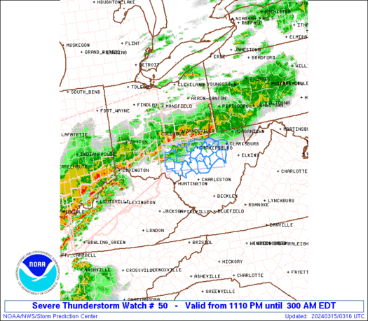
Severe Thunderstorm Watch Number 50
NWS Storm Prediction Center Norman OK
1110 PM EDT Thu Mar 14 2024
The NWS Storm Prediction Center has issued a
* Severe Thunderstorm Watch for portions of
Southeast Ohio
Northern West Virginia
* Effective this Thursday night and Friday morning from 1110 PM
until 300 AM EDT.
* Primary threats include...
Scattered damaging wind gusts to 70 mph possible
Isolated large hail events to 1.5 inches in diameter possible
SUMMARY...Scattered fast-moving storms over Ohio will track eastward
across northern West Virginia during the next few hours, posing some
risk of hail and locally damaging wind gusts.
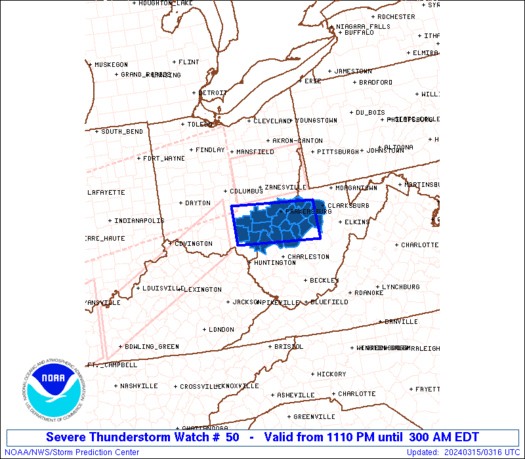
The severe thunderstorm watch area is approximately along and 30
statute miles north and south of a line from 30 miles west of Athens
OH to 55 miles east southeast of Parkersburg WV. For a complete
depiction of the watch see the associated watch outline update
(WOUS64 KWNS WOU0).
PRECAUTIONARY/PREPAREDNESS ACTIONS...
REMEMBER...A Severe Thunderstorm Watch means conditions are
favorable for severe thunderstorms in and close to the watch area.
Persons in these areas should be on the lookout for threatening
weather conditions and listen for later statements and possible
warnings. Severe thunderstorms can and occasionally do produce
tornadoes.
&&
OTHER WATCH INFORMATION...CONTINUE...WW 44...WW 45...WW 46...WW
47...WW 48...WW 49...
AVIATION...A few severe thunderstorms with hail surface and aloft to
1.5 inches. Extreme turbulence and surface wind gusts to 60 knots. A
few cumulonimbi with maximum tops to 450. Mean storm motion vector
27035.
...Hart

   SEL0

   URGENT - IMMEDIATE BROADCAST REQUESTED
   Severe Thunderstorm Watch Number 50
   NWS Storm Prediction Center Norman OK
   1110 PM EDT Thu Mar 14 2024

   The NWS Storm Prediction Center has issued a

   * Severe Thunderstorm Watch for portions of
     Southeast Ohio
     Northern West Virginia

   * Effective this Thursday night and Friday morning from 1110 PM
     until 300 AM EDT.

   * Primary threats include...
     Scattered damaging wind gusts to 70 mph possible
     Isolated large hail events to 1.5 inches in diameter possible

   SUMMARY...Scattered fast-moving storms over Ohio will track eastward
   across northern West Virginia during the next few hours, posing some
   risk of hail and locally damaging wind gusts.

   The severe thunderstorm watch area is approximately along and 30
   statute miles north and south of a line from 30 miles west of Athens
   OH to 55 miles east southeast of Parkersburg WV. For a complete
   depiction of the watch see the associated watch outline update
   (WOUS64 KWNS WOU0).

   PRECAUTIONARY/PREPAREDNESS ACTIONS...

   REMEMBER...A Severe Thunderstorm Watch means conditions are
   favorable for severe thunderstorms in and close to the watch area.
   Persons in these areas should be on the lookout for threatening
   weather conditions and listen for later statements and possible
   warnings. Severe thunderstorms can and occasionally do produce
   tornadoes.

   &&

   OTHER WATCH INFORMATION...CONTINUE...WW 44...WW 45...WW 46...WW
   47...WW 48...WW 49...

   AVIATION...A few severe thunderstorms with hail surface and aloft to
   1.5 inches. Extreme turbulence and surface wind gusts to 60 knots. A
   few cumulonimbi with maximum tops to 450. Mean storm motion vector
   27035.

   ...Hart
 Note:
The Aviation Watch (SAW) product is an approximation to the watch area.
The actual watch is depicted by the shaded areas.
Note:
The Aviation Watch (SAW) product is an approximation to the watch area.
The actual watch is depicted by the shaded areas.
   SAW0
   WW 50 SEVERE TSTM OH WV 150310Z - 150700Z
   AXIS..30 STATUTE MILES NORTH AND SOUTH OF LINE..
   30W UNI/ATHENS OH/ - 55ESE PKB/PARKERSBURG WV/
   ..AVIATION COORDS.. 25NM N/S /45NW HNN - 19WNW EKN/
   HAIL SURFACE AND ALOFT..1.5 INCHES. WIND GUSTS..60 KNOTS.
   MAX TOPS TO 450. MEAN STORM MOTION VECTOR 27035.

   LAT...LON 39658279 39488048 38618048 38788279

   THIS IS AN APPROXIMATION TO THE WATCH AREA.  FOR A
   COMPLETE DEPICTION OF THE WATCH SEE WOUS64 KWNS
   FOR WOU0.
Watch 50 Status Report Messages:
STATUS REPORT #3 ON WW 50

VALID 150650Z - 150700Z

SEVERE WEATHER THREAT CONTINUES RIGHT OF A LINE FROM 20 NE HTS TO
30 SSW PKB TO 10 WNW EKN.

WW 50 WILL BE ALLOWED TO EXPIRE AT 150700Z.

..DEAN..03/15/24

ATTN...WFO...RLX...

&&

STATUS REPORT FOR WS 50

SEVERE WEATHER THREAT CONTINUES FOR THE FOLLOWING AREAS

WVC013-021-035-041-053-087-150700-

WV
.    WEST VIRGINIA COUNTIES INCLUDED ARE

CALHOUN 	     GILMER		 JACKSON
LEWIS		     MASON		 ROANE
$$


THE WATCH STATUS MESSAGE IS FOR GUIDANCE PURPOSES ONLY.  PLEASE
REFER TO WATCH COUNTY NOTIFICATION STATEMENTS FOR OFFICIAL
INFORMATION ON COUNTIES...INDEPENDENT CITIES AND MARINE ZONES
CLEARED FROM SEVERE THUNDERSTORM AND TORNADO WATCHES.
$$

STATUS REPORT #2 ON WW 50

VALID 150550Z - 150640Z

SEVERE WEATHER THREAT CONTINUES RIGHT OF A LINE FROM 25 NNW HTS
TO 5 S UNI TO 25 N EKN.

..DEAN..03/15/24

ATTN...WFO...RLX...

&&

STATUS REPORT FOR WS 50

SEVERE WEATHER THREAT CONTINUES FOR THE FOLLOWING AREAS

OHC053-105-150640-

OH
.    OHIO COUNTIES INCLUDED ARE

GALLIA		     MEIGS
$$


WVC013-021-035-041-053-085-087-105-107-150640-

WV
.    WEST VIRGINIA COUNTIES INCLUDED ARE

CALHOUN 	     GILMER		 JACKSON
LEWIS		     MASON		 RITCHIE
ROANE		     WIRT		 WOOD
$$


THE WATCH STATUS MESSAGE IS FOR GUIDANCE PURPOSES ONLY.  PLEASE
REFER TO WATCH COUNTY NOTIFICATION STATEMENTS FOR OFFICIAL
INFORMATION ON COUNTIES...INDEPENDENT CITIES AND MARINE ZONES
CLEARED FROM SEVERE THUNDERSTORM AND TORNADO WATCHES.
$$

STATUS REPORT #1 ON WW 50

VALID 150430Z - 150540Z

SEVERE WEATHER THREAT CONTINUES RIGHT OF A LINE FROM 30 W UNI TO
30 WSW MGW.

FOR ADDITIONAL INFORMATION SEE MESOSCALE DISCUSSION 251

..HART..03/15/24

ATTN...WFO...RLX...

&&

STATUS REPORT FOR WS 50

SEVERE WEATHER THREAT CONTINUES FOR THE FOLLOWING AREAS

OHC009-053-079-105-163-167-150540-

OH
.    OHIO COUNTIES INCLUDED ARE

ATHENS		     GALLIA		 JACKSON
MEIGS		     VINTON		 WASHINGTON
$$


WVC013-017-021-033-035-041-053-073-085-087-095-105-107-150540-

WV
.    WEST VIRGINIA COUNTIES INCLUDED ARE

CALHOUN 	     DODDRIDGE		 GILMER
HARRISON	     JACKSON		 LEWIS
MASON		     PLEASANTS		 RITCHIE
ROANE		     TYLER		 WIRT
WOOD
$$


THE WATCH STATUS MESSAGE IS FOR GUIDANCE PURPOSES ONLY.  PLEASE
REFER TO WATCH COUNTY NOTIFICATION STATEMENTS FOR OFFICIAL
INFORMATION ON COUNTIES...INDEPENDENT CITIES AND MARINE ZONES
CLEARED FROM SEVERE THUNDERSTORM AND TORNADO WATCHES.
$$
Note:
Click for Complete Product Text.
Tornadoes
Probability of 2 or more tornadoes
|
Low (10%)
|
Probability of 1 or more strong (EF2-EF5) tornadoes
|
Low (<2%)
|
Wind
Probability of 10 or more severe wind events
|
Mod (40%)
|
Probability of 1 or more wind events > 65 knots
|
Low (20%)
|
Hail
Probability of 10 or more severe hail events
|
Low (20%)
|
Probability of 1 or more hailstones > 2 inches
|
Low (10%)
|
Combined Severe Hail/Wind
Probability of 6 or more combined severe hail/wind events
|
Mod (60%)
|
For each watch, probabilities for particular events inside the watch
(listed above in each table) are determined by the issuing forecaster.
The "Low" category contains probability values ranging from less than 2%
to 20% (EF2-EF5 tornadoes), less than 5% to 20% (all other probabilities),
"Moderate" from 30% to 60%, and "High" from 70% to greater than 95%.
High values are bolded and lighter in color to provide awareness of
an increased threat for a particular event.


 @NWSSPC


