 Note:
The expiration time in the watch graphic is amended if the watch is
replaced, cancelled or extended.
Note:
Note:
The expiration time in the watch graphic is amended if the watch is
replaced, cancelled or extended.
Note: Click for
Watch Status Reports.
SEL7
URGENT - IMMEDIATE BROADCAST REQUESTED
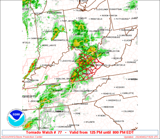
Tornado Watch Number 77
NWS Storm Prediction Center Norman OK
125 PM EDT Tue Apr 2 2024
The NWS Storm Prediction Center has issued a
* Tornado Watch for portions of
Eastern Kentucky
* Effective this Tuesday afternoon and evening from 125 PM until
800 PM EDT.
* Primary threats include...
A few tornadoes likely with a couple intense tornadoes possible
Scattered damaging winds likely with isolated significant gusts
to 75 mph possible
Scattered large hail likely with isolated very large hail events
to 2 inches in diameter possible
SUMMARY...Supercells will be possible this afternoon along a remnant
outflow boundary from storms this morning. The environment will
become more favorable for tornadoes with time through the afternoon,
and a couple of strong (EF2+) tornadoes will be possible.
Otherwise, large hail (1-2 inch diameter) and damaging gusts (60-75
mph) will also be possible.
The tornado watch area is approximately along and 45 statute miles
north and south of a line from 55 miles west of London KY to 60
miles east northeast of Jackson KY. For a complete depiction of the
watch see the associated watch outline update (WOUS64 KWNS WOU7).
PRECAUTIONARY/PREPAREDNESS ACTIONS...
REMEMBER...A Tornado Watch means conditions are favorable for
tornadoes and severe thunderstorms in and close to the watch
area. Persons in these areas should be on the lookout for
threatening weather conditions and listen for later statements
and possible warnings.
&&
OTHER WATCH INFORMATION...CONTINUE...WW 75...WW 76...
AVIATION...Tornadoes and a few severe thunderstorms with hail
surface and aloft to 2 inches. Extreme turbulence and surface wind
gusts to 65 knots. A few cumulonimbi with maximum tops to 500. Mean
storm motion vector 25045.
...Thompson

   SEL7

   URGENT - IMMEDIATE BROADCAST REQUESTED
   Tornado Watch Number 77
   NWS Storm Prediction Center Norman OK
   125 PM EDT Tue Apr 2 2024

   The NWS Storm Prediction Center has issued a

   * Tornado Watch for portions of
     Eastern Kentucky

   * Effective this Tuesday afternoon and evening from 125 PM until
     800 PM EDT.

   * Primary threats include...
     A few tornadoes likely with a couple intense tornadoes possible
     Scattered damaging winds likely with isolated significant gusts
       to 75 mph possible
     Scattered large hail likely with isolated very large hail events
       to 2 inches in diameter possible

   SUMMARY...Supercells will be possible this afternoon along a remnant
   outflow boundary from storms this morning.  The environment will
   become more favorable for tornadoes with time through the afternoon,
   and a couple of strong (EF2+) tornadoes will be possible.
   Otherwise, large hail (1-2 inch diameter) and damaging gusts (60-75
   mph) will also be possible.

   The tornado watch area is approximately along and 45 statute miles
   north and south of a line from 55 miles west of London KY to 60
   miles east northeast of Jackson KY. For a complete depiction of the
   watch see the associated watch outline update (WOUS64 KWNS WOU7).

   PRECAUTIONARY/PREPAREDNESS ACTIONS...

   REMEMBER...A Tornado Watch means conditions are favorable for
   tornadoes and severe thunderstorms in and close to the watch
   area. Persons in these areas should be on the lookout for
   threatening weather conditions and listen for later statements
   and possible warnings.

   &&

   OTHER WATCH INFORMATION...CONTINUE...WW 75...WW 76...

   AVIATION...Tornadoes and a few severe thunderstorms with hail
   surface and aloft to 2 inches. Extreme turbulence and surface wind
   gusts to 65 knots. A few cumulonimbi with maximum tops to 500. Mean
   storm motion vector 25045.

   ...Thompson
 Note:
The Aviation Watch (SAW) product is an approximation to the watch area.
The actual watch is depicted by the shaded areas.
Note:
The Aviation Watch (SAW) product is an approximation to the watch area.
The actual watch is depicted by the shaded areas.
   SAW7
   WW 77 TORNADO KY 021725Z - 030000Z
   AXIS..45 STATUTE MILES NORTH AND SOUTH OF LINE..
   55W LOZ/LONDON KY/ - 60ENE JKL/JACKSON KY/
   ..AVIATION COORDS.. 40NM N/S /46W LOZ - 55SSW HNN/
   HAIL SURFACE AND ALOFT..2 INCHES. WIND GUSTS..65 KNOTS.
   MAX TOPS TO 500. MEAN STORM MOTION VECTOR 25045.

   LAT...LON 37738508 38528236 37228236 36418508

   THIS IS AN APPROXIMATION TO THE WATCH AREA.  FOR A
   COMPLETE DEPICTION OF THE WATCH SEE WOUS64 KWNS
   FOR WOU7.
Watch 77 Status Report Messages:
STATUS REPORT #4 ON WW 77

VALID 022110Z - 022240Z

THE SEVERE WEATHER THREAT CONTINUES ACROSS THE ENTIRE WATCH AREA.

..LYONS..04/02/24

ATTN...WFO...JKL...

&&

STATUS REPORT FOR WT 77

SEVERE WEATHER THREAT CONTINUES FOR THE FOLLOWING AREAS

KYC011-013-025-051-063-065-069-071-095-109-115-119-121-125-129-
131-133-147-153-159-165-173-175-189-193-195-197-199-203-205-231-
235-237-022240-

KY
.    KENTUCKY COUNTIES INCLUDED ARE

BATH		     BELL		 BREATHITT
CLAY		     ELLIOTT		 ESTILL
FLEMING 	     FLOYD		 HARLAN
JACKSON 	     JOHNSON		 KNOTT
KNOX		     LAUREL		 LEE
LESLIE		     LETCHER		 MCCREARY
MAGOFFIN	     MARTIN		 MENIFEE
MONTGOMERY	     MORGAN		 OWSLEY
PERRY		     PIKE		 POWELL
PULASKI 	     ROCKCASTLE 	 ROWAN
WAYNE		     WHITLEY		 WOLFE
$$


THE WATCH STATUS MESSAGE IS FOR GUIDANCE PURPOSES ONLY.  PLEASE
REFER TO WATCH COUNTY NOTIFICATION STATEMENTS FOR OFFICIAL
INFORMATION ON COUNTIES...INDEPENDENT CITIES AND MARINE ZONES
CLEARED FROM SEVERE THUNDERSTORM AND TORNADO WATCHES.
$$

STATUS REPORT #3 ON WW 77

VALID 022010Z - 022140Z

THE SEVERE WEATHER THREAT CONTINUES ACROSS THE ENTIRE WATCH AREA.

..LYONS..04/02/24

ATTN...WFO...JKL...

&&

STATUS REPORT FOR WT 77

SEVERE WEATHER THREAT CONTINUES FOR THE FOLLOWING AREAS

KYC011-013-025-051-063-065-069-071-095-109-115-119-121-125-129-
131-133-147-153-159-165-173-175-189-193-195-197-199-203-205-231-
235-237-022140-

KY
.    KENTUCKY COUNTIES INCLUDED ARE

BATH		     BELL		 BREATHITT
CLAY		     ELLIOTT		 ESTILL
FLEMING 	     FLOYD		 HARLAN
JACKSON 	     JOHNSON		 KNOTT
KNOX		     LAUREL		 LEE
LESLIE		     LETCHER		 MCCREARY
MAGOFFIN	     MARTIN		 MENIFEE
MONTGOMERY	     MORGAN		 OWSLEY
PERRY		     PIKE		 POWELL
PULASKI 	     ROCKCASTLE 	 ROWAN
WAYNE		     WHITLEY		 WOLFE
$$


THE WATCH STATUS MESSAGE IS FOR GUIDANCE PURPOSES ONLY.  PLEASE
REFER TO WATCH COUNTY NOTIFICATION STATEMENTS FOR OFFICIAL
INFORMATION ON COUNTIES...INDEPENDENT CITIES AND MARINE ZONES
CLEARED FROM SEVERE THUNDERSTORM AND TORNADO WATCHES.
$$

STATUS REPORT #2 ON WW 77

VALID 021905Z - 022040Z

THE SEVERE WEATHER THREAT CONTINUES ACROSS THE ENTIRE WATCH AREA.

..LYONS..04/02/24

ATTN...WFO...JKL...

&&

STATUS REPORT FOR WT 77

SEVERE WEATHER THREAT CONTINUES FOR THE FOLLOWING AREAS

KYC011-013-025-051-063-065-069-071-095-109-115-119-121-125-129-
131-133-147-153-159-165-173-175-189-193-195-197-199-203-205-231-
235-237-022040-

KY
.    KENTUCKY COUNTIES INCLUDED ARE

BATH		     BELL		 BREATHITT
CLAY		     ELLIOTT		 ESTILL
FLEMING 	     FLOYD		 HARLAN
JACKSON 	     JOHNSON		 KNOTT
KNOX		     LAUREL		 LEE
LESLIE		     LETCHER		 MCCREARY
MAGOFFIN	     MARTIN		 MENIFEE
MONTGOMERY	     MORGAN		 OWSLEY
PERRY		     PIKE		 POWELL
PULASKI 	     ROCKCASTLE 	 ROWAN
WAYNE		     WHITLEY		 WOLFE
$$


THE WATCH STATUS MESSAGE IS FOR GUIDANCE PURPOSES ONLY.  PLEASE
REFER TO WATCH COUNTY NOTIFICATION STATEMENTS FOR OFFICIAL
INFORMATION ON COUNTIES...INDEPENDENT CITIES AND MARINE ZONES
CLEARED FROM SEVERE THUNDERSTORM AND TORNADO WATCHES.
$$

STATUS REPORT #1 ON WW 77

VALID 021735Z - 021840Z

THE SEVERE WEATHER THREAT CONTINUES ACROSS THE ENTIRE WATCH AREA.

..LYONS..04/02/24

ATTN...WFO...JKL...

&&

STATUS REPORT FOR WT 77

SEVERE WEATHER THREAT CONTINUES FOR THE FOLLOWING AREAS

KYC011-013-025-051-063-065-069-071-095-109-115-119-121-125-129-
131-133-147-153-159-165-173-175-189-193-195-197-199-203-205-231-
235-237-021840-

KY
.    KENTUCKY COUNTIES INCLUDED ARE

BATH		     BELL		 BREATHITT
CLAY		     ELLIOTT		 ESTILL
FLEMING 	     FLOYD		 HARLAN
JACKSON 	     JOHNSON		 KNOTT
KNOX		     LAUREL		 LEE
LESLIE		     LETCHER		 MCCREARY
MAGOFFIN	     MARTIN		 MENIFEE
MONTGOMERY	     MORGAN		 OWSLEY
PERRY		     PIKE		 POWELL
PULASKI 	     ROCKCASTLE 	 ROWAN
WAYNE		     WHITLEY		 WOLFE
$$


THE WATCH STATUS MESSAGE IS FOR GUIDANCE PURPOSES ONLY.  PLEASE
REFER TO WATCH COUNTY NOTIFICATION STATEMENTS FOR OFFICIAL
INFORMATION ON COUNTIES...INDEPENDENT CITIES AND MARINE ZONES
CLEARED FROM SEVERE THUNDERSTORM AND TORNADO WATCHES.
$$
Note:
Click for Complete Product Text.
Tornadoes
Probability of 2 or more tornadoes
|
High (70%)
|
Probability of 1 or more strong (EF2-EF5) tornadoes
|
Mod (50%)
|
Wind
Probability of 10 or more severe wind events
|
High (70%)
|
Probability of 1 or more wind events > 65 knots
|
Mod (50%)
|
Hail
Probability of 10 or more severe hail events
|
Mod (60%)
|
Probability of 1 or more hailstones > 2 inches
|
Mod (50%)
|
Combined Severe Hail/Wind
Probability of 6 or more combined severe hail/wind events
|
High (>95%)
|
For each watch, probabilities for particular events inside the watch
(listed above in each table) are determined by the issuing forecaster.
The "Low" category contains probability values ranging from less than 2%
to 20% (EF2-EF5 tornadoes), less than 5% to 20% (all other probabilities),
"Moderate" from 30% to 60%, and "High" from 70% to greater than 95%.
High values are bolded and lighter in color to provide awareness of
an increased threat for a particular event.


 @NWSSPC


