 Note:
The expiration time in the watch graphic is amended if the watch is
replaced, cancelled or extended.
Note:
Note:
The expiration time in the watch graphic is amended if the watch is
replaced, cancelled or extended.
Note: Click for
Watch Status Reports.
SEL7
URGENT - IMMEDIATE BROADCAST REQUESTED
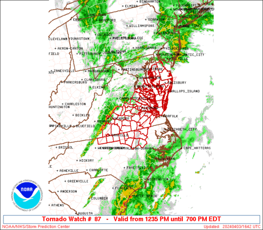
Tornado Watch Number 87
NWS Storm Prediction Center Norman OK
1235 PM EDT Wed Apr 3 2024
The NWS Storm Prediction Center has issued a
* Tornado Watch for portions of
Southern Delaware
Eastern Maryland
Northern North Carolina
Southern and eastern Virginia
Coastal Waters
* Effective this Wednesday afternoon and evening from 1235 PM
until 700 PM EDT.
* Primary threats include...
A couple tornadoes possible
Scattered damaging winds and isolated significant gusts to 75
mph possible
Isolated large hail events to 1.5 inches in diameter possible
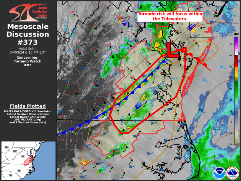
SUMMARY...Scattered severe storm development is expected this
afternoon along and east of a surface front and deepening cyclone
moving across Virginia. The storm environment will favor a mix of
line segments and supercells capable of producing a couple of
tornadoes, damaging gusts of 60-75 mph, and isolated large hail of
1-1.5 inches in diameter.
The tornado watch area is approximately along and 60 statute miles
east and west of a line from 25 miles west northwest of Salisbury MD
to 30 miles southeast of Danville VA. For a complete depiction of
the watch see the associated watch outline update (WOUS64 KWNS
WOU7).
PRECAUTIONARY/PREPAREDNESS ACTIONS...
REMEMBER...A Tornado Watch means conditions are favorable for
tornadoes and severe thunderstorms in and close to the watch
area. Persons in these areas should be on the lookout for
threatening weather conditions and listen for later statements
and possible warnings.
&&
OTHER WATCH INFORMATION...CONTINUE...WW 85...WW 86...
AVIATION...Tornadoes and a few severe thunderstorms with hail
surface and aloft to 1.5 inches. Extreme turbulence and surface wind
gusts to 65 knots. A few cumulonimbi with maximum tops to 450. Mean
storm motion vector 23050.
...Thompson

   SEL7

   URGENT - IMMEDIATE BROADCAST REQUESTED
   Tornado Watch Number 87
   NWS Storm Prediction Center Norman OK
   1235 PM EDT Wed Apr 3 2024

   The NWS Storm Prediction Center has issued a

   * Tornado Watch for portions of
     Southern Delaware
     Eastern Maryland
     Northern North Carolina
     Southern and eastern Virginia
     Coastal Waters

   * Effective this Wednesday afternoon and evening from 1235 PM
     until 700 PM EDT.

   * Primary threats include...
     A couple tornadoes possible
     Scattered damaging winds and isolated significant gusts to 75
       mph possible
     Isolated large hail events to 1.5 inches in diameter possible

   SUMMARY...Scattered severe storm development is expected this
   afternoon along and east of a surface front and deepening cyclone
   moving across Virginia.  The storm environment will favor a mix of
   line segments and supercells capable of producing a couple of
   tornadoes, damaging gusts of 60-75 mph, and isolated large hail of
   1-1.5 inches in diameter.

   The tornado watch area is approximately along and 60 statute miles
   east and west of a line from 25 miles west northwest of Salisbury MD
   to 30 miles southeast of Danville VA. For a complete depiction of
   the watch see the associated watch outline update (WOUS64 KWNS
   WOU7).

   PRECAUTIONARY/PREPAREDNESS ACTIONS...

   REMEMBER...A Tornado Watch means conditions are favorable for
   tornadoes and severe thunderstorms in and close to the watch
   area. Persons in these areas should be on the lookout for
   threatening weather conditions and listen for later statements
   and possible warnings.

   &&

   OTHER WATCH INFORMATION...CONTINUE...WW 85...WW 86...

   AVIATION...Tornadoes and a few severe thunderstorms with hail
   surface and aloft to 1.5 inches. Extreme turbulence and surface wind
   gusts to 65 knots. A few cumulonimbi with maximum tops to 450. Mean
   storm motion vector 23050.

   ...Thompson
 Note:
The Aviation Watch (SAW) product is an approximation to the watch area.
The actual watch is depicted by the shaded areas.
Note:
The Aviation Watch (SAW) product is an approximation to the watch area.
The actual watch is depicted by the shaded areas.
   SAW7
   WW 87 TORNADO DE MD NC VA CW 031635Z - 032300Z
   AXIS..60 STATUTE MILES EAST AND WEST OF LINE..
   25WNW SBY/SALISBURY MD/ - 30SE DAN/DANVILLE VA/
   ..AVIATION COORDS.. 50NM E/W /20WNW SBY - 25NNW RDU/
   HAIL SURFACE AND ALOFT..1.5 INCHES. WIND GUSTS..65 KNOTS.
   MAX TOPS TO 450. MEAN STORM MOTION VECTOR 23050.

   LAT...LON 38467482 36257787 36258003 38467704

   THIS IS AN APPROXIMATION TO THE WATCH AREA.  FOR A
   COMPLETE DEPICTION OF THE WATCH SEE WOUS64 KWNS
   FOR WOU7.
Watch 87 Status Report Messages:
STATUS REPORT #4 ON WW 87

VALID 032135Z - 032240Z

SEVERE WEATHER THREAT CONTINUES RIGHT OF A LINE FROM 35 E RZZ TO
35 SE RIC TO 10 SSW NHK TO 10 NW DOV.

..LYONS..04/03/24

ATTN...WFO...PHI...LWX...AKQ...RNK...RAH...

&&

STATUS REPORT FOR WT 87

SEVERE WEATHER THREAT CONTINUES FOR THE FOLLOWING AREAS

DEC001-005-032240-

DE
.    DELAWARE COUNTIES INCLUDED ARE

KENT		     SUSSEX
$$


MDC011-019-039-045-047-032240-

MD
.    MARYLAND COUNTIES INCLUDED ARE

CAROLINE	     DORCHESTER 	 SOMERSET
WICOMICO	     WORCESTER
$$


NCC073-091-032240-

NC
.    NORTH CAROLINA COUNTIES INCLUDED ARE

GATES		     HERTFORD
$$


VAC001-073-093-095-103-115-119-131-133-199-550-650-700-710-735-
740-800-810-830-032240-

VA
.    VIRGINIA COUNTIES INCLUDED ARE

ACCOMACK	     GLOUCESTER 	 ISLE OF WIGHT
JAMES CITY	     LANCASTER		 MATHEWS
MIDDLESEX	     NORTHAMPTON	 NORTHUMBERLAND
YORK


VIRGINIA INDEPENDENT CITIES INCLUDED ARE

CHESAPEAKE	     HAMPTON		 NEWPORT NEWS
NORFOLK 	     POQUOSON		 PORTSMOUTH
SUFFOLK 	     VIRGINIA BEACH	 WILLIAMSBURG
$$


ANZ630-631-632-634-635-636-637-638-032240-

CW

.    ADJACENT COASTAL WATERS INCLUDED ARE

CHESAPEAKE BAY FROM SMITH POINT TO WINDMILL POINT VA

CHESAPEAKE BAY FROM WINDMILL POINT TO NEW POINT COMFORT VA

CHESAPEAKE BAY FROM NEW POINT COMFORT TO LITTLE CREEK VA

CHESAPEAKE BAY FROM LITTLE CREEK VA TO CAPE HENRY VA INCLUDING
THE CHESAPEAKE BAY BRIDGE TUNNEL

RAPPAHANNOCK RIVER FROM URBANNA TO WINDMILL POINT

YORK RIVER

JAMES RIVER FROM JAMESTOWN TO THE JAMES RIVER BRIDGE

JAMES RIVER FROM JAMES RIVER BRIDGE TO HAMPTON ROADS
BRIDGE-TUNNEL

$$
THE WATCH STATUS MESSAGE IS FOR GUIDANCE PURPOSES ONLY.  PLEASE
REFER TO WATCH COUNTY NOTIFICATION STATEMENTS FOR OFFICIAL
INFORMATION ON COUNTIES...INDEPENDENT CITIES AND MARINE ZONES
CLEARED FROM SEVERE THUNDERSTORM AND TORNADO WATCHES.
$$

STATUS REPORT #3 ON WW 87

VALID 032050Z - 032140Z

SEVERE WEATHER THREAT CONTINUES RIGHT OF A LINE FROM 35 NNE RDU
TO 30 SW RIC TO 35 NE RIC TO 20 ESE DCA.

..LYONS..04/03/24

ATTN...WFO...PHI...LWX...AKQ...RNK...RAH...

&&

STATUS REPORT FOR WT 87

SEVERE WEATHER THREAT CONTINUES FOR THE FOLLOWING AREAS

DEC001-005-032140-

DE
.    DELAWARE COUNTIES INCLUDED ARE

KENT		     SUSSEX
$$


MDC009-011-019-035-037-039-041-045-047-032140-

MD
.    MARYLAND COUNTIES INCLUDED ARE

CALVERT 	     CAROLINE		 DORCHESTER
QUEEN ANNE'S	     ST. MARYS		 SOMERSET
TALBOT		     WICOMICO		 WORCESTER
$$


NCC065-069-073-083-091-127-131-185-032140-

NC
.    NORTH CAROLINA COUNTIES INCLUDED ARE

EDGECOMBE	     FRANKLIN		 GATES
HALIFAX 	     HERTFORD		 NASH
NORTHAMPTON	     WARREN
$$


VAC001-025-036-053-073-081-093-095-097-103-115-119-127-131-133-
149-159-175-181-183-193-199-550-570-595-620-650-670-700-710-730-
735-740-800-810-830-032140-

VA
.    VIRGINIA COUNTIES INCLUDED ARE

ACCOMACK	     BRUNSWICK		 CHARLES CITY
DINWIDDIE	     GLOUCESTER 	 GREENSVILLE
ISLE OF WIGHT	     JAMES CITY 	 KING AND QUEEN
LANCASTER	     MATHEWS		 MIDDLESEX
NEW KENT	     NORTHAMPTON	 NORTHUMBERLAND
PRINCE GEORGE	     RICHMOND		 SOUTHAMPTON
SURRY		     SUSSEX		 WESTMORELAND
YORK


VIRGINIA INDEPENDENT CITIES INCLUDED ARE

CHESAPEAKE	     COLONIAL HEIGHTS	 EMPORIA
FRANKLIN	     HAMPTON		 HOPEWELL
NEWPORT NEWS	     NORFOLK		 PETERSBURG
POQUOSON	     PORTSMOUTH 	 SUFFOLK
VIRGINIA BEACH	     WILLIAMSBURG
$$


ANZ533-534-537-541-542-543-630-631-632-634-635-636-637-638-
032140-

CW

.    ADJACENT COASTAL WATERS INCLUDED ARE

CHESAPEAKE BAY FROM NORTH BEACH TO DRUM POINT MD

CHESAPEAKE BAY FROM DRUM POINT MD TO SMITH POINT VA

TIDAL POTOMAC FROM COBB ISLAND MD TO SMITH POINT VA

CHOPTANK RIVER TO CAMBRIDGE MD AND THE LITTLE CHOPTANK RIVER

PATUXENT RIVER TO BROOMES ISLAND MD

TANGIER SOUND AND THE INLAND WATERS SURROUNDING BLOODSWORTH
ISLAND

CHESAPEAKE BAY FROM SMITH POINT TO WINDMILL POINT VA

CHESAPEAKE BAY FROM WINDMILL POINT TO NEW POINT COMFORT VA

CHESAPEAKE BAY FROM NEW POINT COMFORT TO LITTLE CREEK VA

CHESAPEAKE BAY FROM LITTLE CREEK VA TO CAPE HENRY VA INCLUDING
THE CHESAPEAKE BAY BRIDGE TUNNEL

RAPPAHANNOCK RIVER FROM URBANNA TO WINDMILL POINT

YORK RIVER

JAMES RIVER FROM JAMESTOWN TO THE JAMES RIVER BRIDGE

JAMES RIVER FROM JAMES RIVER BRIDGE TO HAMPTON ROADS
BRIDGE-TUNNEL

$$
THE WATCH STATUS MESSAGE IS FOR GUIDANCE PURPOSES ONLY.  PLEASE
REFER TO WATCH COUNTY NOTIFICATION STATEMENTS FOR OFFICIAL
INFORMATION ON COUNTIES...INDEPENDENT CITIES AND MARINE ZONES
CLEARED FROM SEVERE THUNDERSTORM AND TORNADO WATCHES.
$$

STATUS REPORT #2 ON WW 87

VALID 031930Z - 032040Z

SEVERE WEATHER THREAT CONTINUES RIGHT OF A LINE FROM 15 NE GSO TO
30 ESE DAN TO 25 NW AVC TO 25 NW RIC TO 30 SSW DCA TO 5 WSW DCA.

..LYONS..04/03/24

ATTN...WFO...PHI...LWX...AKQ...RNK...RAH...

&&

STATUS REPORT FOR WT 87

SEVERE WEATHER THREAT CONTINUES FOR THE FOLLOWING AREAS

DEC001-005-032040-

DE
.    DELAWARE COUNTIES INCLUDED ARE

KENT		     SUSSEX
$$


MDC009-011-019-035-037-039-041-045-047-032040-

MD
.    MARYLAND COUNTIES INCLUDED ARE

CALVERT 	     CAROLINE		 DORCHESTER
QUEEN ANNE'S	     ST. MARYS		 SOMERSET
TALBOT		     WICOMICO		 WORCESTER
$$


NCC065-069-077-083-127-131-145-181-185-032040-

NC
.    NORTH CAROLINA COUNTIES INCLUDED ARE

EDGECOMBE	     FRANKLIN		 GRANVILLE
HALIFAX 	     NASH		 NORTHAMPTON
PERSON		     VANCE		 WARREN
$$


VAC001-025-033-036-041-053-057-073-081-085-087-093-095-097-099-
101-103-115-117-119-127-131-133-135-149-159-175-181-183-193-199-
570-595-620-650-670-700-730-735-760-830-032040-

VA
.    VIRGINIA COUNTIES INCLUDED ARE

ACCOMACK	     BRUNSWICK		 CAROLINE
CHARLES CITY	     CHESTERFIELD	 DINWIDDIE
ESSEX		     GLOUCESTER 	 GREENSVILLE
HANOVER 	     HENRICO		 ISLE OF WIGHT
JAMES CITY	     KING AND QUEEN	 KING GEORGE
KING WILLIAM	     LANCASTER		 MATHEWS
MECKLENBURG	     MIDDLESEX		 NEW KENT
NORTHAMPTON	     NORTHUMBERLAND	 NOTTOWAY
PRINCE GEORGE	     RICHMOND		 SOUTHAMPTON
SURRY		     SUSSEX		 WESTMORELAND
YORK


VIRGINIA INDEPENDENT CITIES INCLUDED ARE

COLONIAL HEIGHTS     EMPORIA		 FRANKLIN
HAMPTON 	     HOPEWELL		 NEWPORT NEWS
PETERSBURG	     POQUOSON		 RICHMOND
WILLIAMSBURG
$$


ANZ533-534-537-541-542-543-630-631-632-635-636-637-638-032040-

CW

.    ADJACENT COASTAL WATERS INCLUDED ARE

CHESAPEAKE BAY FROM NORTH BEACH TO DRUM POINT MD

CHESAPEAKE BAY FROM DRUM POINT MD TO SMITH POINT VA

TIDAL POTOMAC FROM COBB ISLAND MD TO SMITH POINT VA

CHOPTANK RIVER TO CAMBRIDGE MD AND THE LITTLE CHOPTANK RIVER

PATUXENT RIVER TO BROOMES ISLAND MD

TANGIER SOUND AND THE INLAND WATERS SURROUNDING BLOODSWORTH
ISLAND

CHESAPEAKE BAY FROM SMITH POINT TO WINDMILL POINT VA

CHESAPEAKE BAY FROM WINDMILL POINT TO NEW POINT COMFORT VA

CHESAPEAKE BAY FROM NEW POINT COMFORT TO LITTLE CREEK VA

RAPPAHANNOCK RIVER FROM URBANNA TO WINDMILL POINT

YORK RIVER

JAMES RIVER FROM JAMESTOWN TO THE JAMES RIVER BRIDGE

JAMES RIVER FROM JAMES RIVER BRIDGE TO HAMPTON ROADS
BRIDGE-TUNNEL

$$
THE WATCH STATUS MESSAGE IS FOR GUIDANCE PURPOSES ONLY.  PLEASE
REFER TO WATCH COUNTY NOTIFICATION STATEMENTS FOR OFFICIAL
INFORMATION ON COUNTIES...INDEPENDENT CITIES AND MARINE ZONES
CLEARED FROM SEVERE THUNDERSTORM AND TORNADO WATCHES.
$$

STATUS REPORT #1 ON WW 87

VALID 031810Z - 031940Z

SEVERE WEATHER THREAT CONTINUES RIGHT OF A LINE FROM 30 WNW DAN
TO 25 SSE LYH TO 40 ESE CHO TO 20 WSW DCA.

..LYONS..04/03/24

ATTN...WFO...PHI...LWX...AKQ...RNK...RAH...

&&

STATUS REPORT FOR WT 87

SEVERE WEATHER THREAT CONTINUES FOR THE FOLLOWING AREAS

DEC001-005-031940-

DE
.    DELAWARE COUNTIES INCLUDED ARE

KENT		     SUSSEX
$$


MDC009-011-019-035-037-039-041-045-047-031940-

MD
.    MARYLAND COUNTIES INCLUDED ARE

CALVERT 	     CAROLINE		 DORCHESTER
QUEEN ANNE'S	     ST. MARYS		 SOMERSET
TALBOT		     WICOMICO		 WORCESTER
$$


NCC033-065-069-077-083-127-131-145-157-181-185-031940-

NC
.    NORTH CAROLINA COUNTIES INCLUDED ARE

CASWELL 	     EDGECOMBE		 FRANKLIN
GRANVILLE	     HALIFAX		 NASH
NORTHAMPTON	     PERSON		 ROCKINGHAM
VANCE		     WARREN
$$


VAC001-007-025-029-033-036-037-041-049-053-057-073-075-081-083-
085-087-093-095-097-099-101-103-111-115-117-119-127-131-133-135-
143-145-147-149-159-175-181-183-193-199-570-590-595-620-650-670-
700-730-735-760-830-031940-

VA
.    VIRGINIA COUNTIES INCLUDED ARE

ACCOMACK	     AMELIA		 BRUNSWICK
BUCKINGHAM	     CAROLINE		 CHARLES CITY
CHARLOTTE	     CHESTERFIELD	 CUMBERLAND
DINWIDDIE	     ESSEX		 GLOUCESTER
GOOCHLAND	     GREENSVILLE	 HALIFAX
HANOVER 	     HENRICO		 ISLE OF WIGHT
JAMES CITY	     KING AND QUEEN	 KING GEORGE
KING WILLIAM	     LANCASTER		 LUNENBURG
MATHEWS 	     MECKLENBURG	 MIDDLESEX
NEW KENT	     NORTHAMPTON	 NORTHUMBERLAND
NOTTOWAY	     PITTSYLVANIA	 POWHATAN
PRINCE EDWARD	     PRINCE GEORGE	 RICHMOND
SOUTHAMPTON	     SURRY		 SUSSEX
WESTMORELAND	     YORK


VIRGINIA INDEPENDENT CITIES INCLUDED ARE

COLONIAL HEIGHTS     DANVILLE		 EMPORIA
FRANKLIN	     HAMPTON		 HOPEWELL
NEWPORT NEWS	     PETERSBURG 	 POQUOSON
RICHMOND	     WILLIAMSBURG
$$


ANZ533-534-537-541-542-543-630-631-632-635-636-637-638-031940-

CW

.    ADJACENT COASTAL WATERS INCLUDED ARE

CHESAPEAKE BAY FROM NORTH BEACH TO DRUM POINT MD

CHESAPEAKE BAY FROM DRUM POINT MD TO SMITH POINT VA

TIDAL POTOMAC FROM COBB ISLAND MD TO SMITH POINT VA

CHOPTANK RIVER TO CAMBRIDGE MD AND THE LITTLE CHOPTANK RIVER

PATUXENT RIVER TO BROOMES ISLAND MD

TANGIER SOUND AND THE INLAND WATERS SURROUNDING BLOODSWORTH
ISLAND

CHESAPEAKE BAY FROM SMITH POINT TO WINDMILL POINT VA

CHESAPEAKE BAY FROM WINDMILL POINT TO NEW POINT COMFORT VA

CHESAPEAKE BAY FROM NEW POINT COMFORT TO LITTLE CREEK VA

RAPPAHANNOCK RIVER FROM URBANNA TO WINDMILL POINT

YORK RIVER

JAMES RIVER FROM JAMESTOWN TO THE JAMES RIVER BRIDGE

JAMES RIVER FROM JAMES RIVER BRIDGE TO HAMPTON ROADS
BRIDGE-TUNNEL

$$
THE WATCH STATUS MESSAGE IS FOR GUIDANCE PURPOSES ONLY.  PLEASE
REFER TO WATCH COUNTY NOTIFICATION STATEMENTS FOR OFFICIAL
INFORMATION ON COUNTIES...INDEPENDENT CITIES AND MARINE ZONES
CLEARED FROM SEVERE THUNDERSTORM AND TORNADO WATCHES.
$$
Note:
Click for Complete Product Text.
Tornadoes
Probability of 2 or more tornadoes
|
Mod (40%)
|
Probability of 1 or more strong (EF2-EF5) tornadoes
|
Low (20%)
|
Wind
Probability of 10 or more severe wind events
|
Mod (40%)
|
Probability of 1 or more wind events > 65 knots
|
Mod (30%)
|
Hail
Probability of 10 or more severe hail events
|
Low (20%)
|
Probability of 1 or more hailstones > 2 inches
|
Low (10%)
|
Combined Severe Hail/Wind
Probability of 6 or more combined severe hail/wind events
|
Mod (60%)
|
For each watch, probabilities for particular events inside the watch
(listed above in each table) are determined by the issuing forecaster.
The "Low" category contains probability values ranging from less than 2%
to 20% (EF2-EF5 tornadoes), less than 5% to 20% (all other probabilities),
"Moderate" from 30% to 60%, and "High" from 70% to greater than 95%.
High values are bolded and lighter in color to provide awareness of
an increased threat for a particular event.


 @NWSSPC