 Note:
The expiration time in the watch graphic is amended if the watch is
replaced, cancelled or extended.
Note:
Note:
The expiration time in the watch graphic is amended if the watch is
replaced, cancelled or extended.
Note: Click for
Watch Status Reports.
SEL7
URGENT - IMMEDIATE BROADCAST REQUESTED
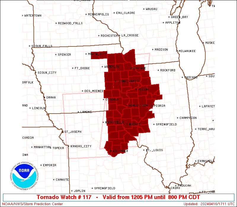
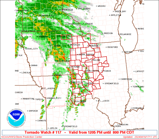
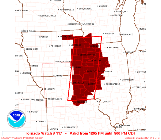
Tornado Watch Number 117
NWS Storm Prediction Center Norman OK
1205 PM CDT Tue Apr 16 2024
The NWS Storm Prediction Center has issued a
* Tornado Watch for portions of
Eastern Iowa
Western and Northwest Illinois
Northeast Missouri
Southwest Wisconsin
* Effective this Tuesday afternoon and evening from 1205 PM until
800 PM CDT.
* Primary threats include...
A few tornadoes likely with a couple intense tornadoes possible
Scattered damaging wind gusts to 70 mph likely
Scattered large hail and isolated very large hail events to 2
inches in diameter possible
SUMMARY...Arcing bands and clusters of severe storms including
supercells will steadily move northeastward across the region
through the afternoon, with the potential for all hazards including
tornadoes, a couple of which could be strong.
The tornado watch area is approximately along and 60 statute miles
east and west of a line from 40 miles north of Dubuque IA to 75
miles south southwest of Quincy IL. For a complete depiction of the
watch see the associated watch outline update (WOUS64 KWNS WOU7).
PRECAUTIONARY/PREPAREDNESS ACTIONS...
REMEMBER...A Tornado Watch means conditions are favorable for
tornadoes and severe thunderstorms in and close to the watch
area. Persons in these areas should be on the lookout for
threatening weather conditions and listen for later statements
and possible warnings.
&&
OTHER WATCH INFORMATION...CONTINUE...WW 116...
AVIATION...Tornadoes and a few severe thunderstorms with hail
surface and aloft to 2 inches. Extreme turbulence and surface wind
gusts to 60 knots. A few cumulonimbi with maximum tops to 500. Mean
storm motion vector 23040.
...Guyer

   SEL7

   URGENT - IMMEDIATE BROADCAST REQUESTED
   Tornado Watch Number 117
   NWS Storm Prediction Center Norman OK
   1205 PM CDT Tue Apr 16 2024

   The NWS Storm Prediction Center has issued a

   * Tornado Watch for portions of
     Eastern Iowa
     Western and Northwest Illinois
     Northeast Missouri
     Southwest Wisconsin

   * Effective this Tuesday afternoon and evening from 1205 PM until
     800 PM CDT.

   * Primary threats include...
     A few tornadoes likely with a couple intense tornadoes possible
     Scattered damaging wind gusts to 70 mph likely
     Scattered large hail and isolated very large hail events to 2
       inches in diameter possible

   SUMMARY...Arcing bands and clusters of severe storms including
   supercells will steadily move northeastward across the region
   through the afternoon, with the potential for all hazards including
   tornadoes, a couple of which could be strong.

   The tornado watch area is approximately along and 60 statute miles
   east and west of a line from 40 miles north of Dubuque IA to 75
   miles south southwest of Quincy IL. For a complete depiction of the
   watch see the associated watch outline update (WOUS64 KWNS WOU7).

   PRECAUTIONARY/PREPAREDNESS ACTIONS...

   REMEMBER...A Tornado Watch means conditions are favorable for
   tornadoes and severe thunderstorms in and close to the watch
   area. Persons in these areas should be on the lookout for
   threatening weather conditions and listen for later statements
   and possible warnings.

   &&

   OTHER WATCH INFORMATION...CONTINUE...WW 116...

   AVIATION...Tornadoes and a few severe thunderstorms with hail
   surface and aloft to 2 inches. Extreme turbulence and surface wind
   gusts to 60 knots. A few cumulonimbi with maximum tops to 500. Mean
   storm motion vector 23040.

   ...Guyer
 Note:
The Aviation Watch (SAW) product is an approximation to the watch area.
The actual watch is depicted by the shaded areas.
Note:
The Aviation Watch (SAW) product is an approximation to the watch area.
The actual watch is depicted by the shaded areas.
   SAW7
   WW 117 TORNADO IA IL MO WI 161705Z - 170100Z
   AXIS..60 STATUTE MILES EAST AND WEST OF LINE..
   40N DBQ/DUBUQUE IA/ - 75SSW UIN/QUINCY IL/
   ..AVIATION COORDS.. 50NM E/W /35N DBQ - 24ENE COU/
   HAIL SURFACE AND ALOFT..2 INCHES. WIND GUSTS..60 KNOTS.
   MAX TOPS TO 500. MEAN STORM MOTION VECTOR 23040.

   LAT...LON 42978953 38939062 38939285 42979191

   THIS IS AN APPROXIMATION TO THE WATCH AREA.  FOR A
   COMPLETE DEPICTION OF THE WATCH SEE WOUS64 KWNS
   FOR WOU7.
Watch 117 Status Report Messages:
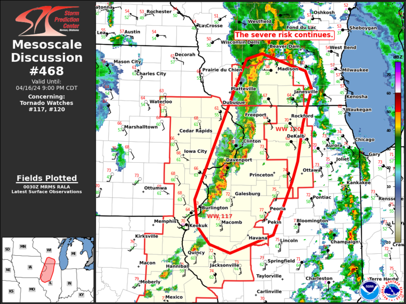
STATUS REPORT #6 ON WW 117

VALID 170040Z - 170140Z

SEVERE WEATHER THREAT CONTINUES RIGHT OF A LINE FROM 40 NNW ALN
TO 20 SSW UIN TO 20 SW BRL TO 5 S LNR.

FOR ADDITIONAL INFORMATION SEE MESOSCALE DISCUSSION 468

..LYONS..04/17/24

ATTN...WFO...DVN...ARX...LSX...ILX...

&&

STATUS REPORT FOR WT 117

SEVERE WEATHER THREAT CONTINUES FOR THE FOLLOWING AREAS

ILC001-009-011-015-017-057-067-071-073-085-095-109-123-125-131-
137-143-149-155-161-169-171-175-177-187-195-170140-

IL
.    ILLINOIS COUNTIES INCLUDED ARE

ADAMS		     BROWN		 BUREAU
CARROLL 	     CASS		 FULTON
HANCOCK 	     HENDERSON		 HENRY
JO DAVIESS	     KNOX		 MCDONOUGH
MARSHALL	     MASON		 MERCER
MORGAN		     PEORIA		 PIKE
PUTNAM		     ROCK ISLAND	 SCHUYLER
SCOTT		     STARK		 STEPHENSON
WARREN		     WHITESIDE
$$


IAC045-097-163-170140-

IA
.    IOWA COUNTIES INCLUDED ARE

CLINTON 	     JACKSON		 SCOTT
$$


THE WATCH STATUS MESSAGE IS FOR GUIDANCE PURPOSES ONLY.  PLEASE
REFER TO WATCH COUNTY NOTIFICATION STATEMENTS FOR OFFICIAL
INFORMATION ON COUNTIES...INDEPENDENT CITIES AND MARINE ZONES
CLEARED FROM SEVERE THUNDERSTORM AND TORNADO WATCHES.
$$

STATUS REPORT #5 ON WW 117

VALID 162335Z - 170040Z

SEVERE WEATHER THREAT CONTINUES RIGHT OF A LINE FROM 25 WNW COU
TO 25 SE IRK TO 25 ENE IRK TO 25 E OTM TO 30 SSW CID TO 35 S ALO
TO 30 WSW ALO TO 30 ESE SPW.

..LYONS..04/16/24

ATTN...WFO...DVN...ARX...LSX...ILX...

&&

STATUS REPORT FOR WT 117

SEVERE WEATHER THREAT CONTINUES FOR THE FOLLOWING AREAS

ILC001-009-011-015-017-057-067-071-073-085-095-109-123-125-131-
137-143-149-155-161-169-171-175-177-187-195-170040-

IL
.    ILLINOIS COUNTIES INCLUDED ARE

ADAMS		     BROWN		 BUREAU
CARROLL 	     CASS		 FULTON
HANCOCK 	     HENDERSON		 HENRY
JO DAVIESS	     KNOX		 MCDONOUGH
MARSHALL	     MASON		 MERCER
MORGAN		     PEORIA		 PIKE
PUTNAM		     ROCK ISLAND	 SCHUYLER
SCOTT		     STARK		 STEPHENSON
WARREN		     WHITESIDE
$$


IAC019-031-037-043-045-055-057-061-065-067-087-097-103-105-111-
113-115-139-163-183-170040-

IA
.    IOWA COUNTIES INCLUDED ARE

BUCHANAN	     CEDAR		 CHICKASAW
CLAYTON 	     CLINTON		 DELAWARE
DES MOINES	     DUBUQUE		 FAYETTE
FLOYD		     HENRY		 JACKSON
JOHNSON 	     JONES		 LEE
LINN		     LOUISA		 MUSCATINE
SCOTT		     WASHINGTON
$$


MOC007-019-027-045-111-127-137-139-163-173-205-170040-

MO
.    MISSOURI COUNTIES INCLUDED ARE

AUDRAIN 	     BOONE		 CALLAWAY
CLARK		     LEWIS		 MARION
MONROE		     MONTGOMERY 	 PIKE
RALLS		     SHELBY
$$


WIC043-170040-

WI
.    WISCONSIN COUNTIES INCLUDED ARE

GRANT
$$


THE WATCH STATUS MESSAGE IS FOR GUIDANCE PURPOSES ONLY.  PLEASE
REFER TO WATCH COUNTY NOTIFICATION STATEMENTS FOR OFFICIAL
INFORMATION ON COUNTIES...INDEPENDENT CITIES AND MARINE ZONES
CLEARED FROM SEVERE THUNDERSTORM AND TORNADO WATCHES.
$$

STATUS REPORT #4 ON WW 117

VALID 162250Z - 162340Z

SEVERE WEATHER THREAT CONTINUES RIGHT OF A LINE FROM 35 ENE SZL
TO 10 SW IRK TO 15 S OXV TO 30 N DSM.

..LYONS..04/16/24

ATTN...WFO...DVN...ARX...LSX...ILX...

&&

STATUS REPORT FOR WT 117

SEVERE WEATHER THREAT CONTINUES FOR THE FOLLOWING AREAS

ILC001-009-011-015-017-057-067-071-073-085-095-109-123-125-131-
137-143-149-155-161-169-171-175-187-195-162340-

IL
.    ILLINOIS COUNTIES INCLUDED ARE

ADAMS		     BROWN		 BUREAU
CARROLL 	     CASS		 FULTON
HANCOCK 	     HENDERSON		 HENRY
JO DAVIESS	     KNOX		 MCDONOUGH
MARSHALL	     MASON		 MERCER
MORGAN		     PEORIA		 PIKE
PUTNAM		     ROCK ISLAND	 SCHUYLER
SCOTT		     STARK		 WARREN
WHITESIDE
$$


IAC011-019-031-037-043-045-055-057-061-065-067-087-095-097-101-
103-105-107-111-113-115-139-163-177-183-162340-

IA
.    IOWA COUNTIES INCLUDED ARE

BENTON		     BUCHANAN		 CEDAR
CHICKASAW	     CLAYTON		 CLINTON
DELAWARE	     DES MOINES 	 DUBUQUE
FAYETTE 	     FLOYD		 HENRY
IOWA		     JACKSON		 JEFFERSON
JOHNSON 	     JONES		 KEOKUK
LEE		     LINN		 LOUISA
MUSCATINE	     SCOTT		 VAN BUREN
WASHINGTON
$$


MOC007-019-027-045-103-111-127-137-139-163-173-199-205-162340-

MO
.    MISSOURI COUNTIES INCLUDED ARE

AUDRAIN 	     BOONE		 CALLAWAY
CLARK		     KNOX		 LEWIS
MARION		     MONROE		 MONTGOMERY
PIKE		     RALLS		 SCOTLAND
SHELBY
$$


WIC043-162340-

WI
.    WISCONSIN COUNTIES INCLUDED ARE

GRANT
$$


THE WATCH STATUS MESSAGE IS FOR GUIDANCE PURPOSES ONLY.  PLEASE
REFER TO WATCH COUNTY NOTIFICATION STATEMENTS FOR OFFICIAL
INFORMATION ON COUNTIES...INDEPENDENT CITIES AND MARINE ZONES
CLEARED FROM SEVERE THUNDERSTORM AND TORNADO WATCHES.
$$

STATUS REPORT #3 ON WW 117

VALID 162020Z - 162140Z

THE SEVERE WEATHER THREAT CONTINUES ACROSS THE ENTIRE WATCH AREA.

..LEITMAN..04/16/24

ATTN...WFO...DVN...ARX...LSX...ILX...

&&

STATUS REPORT FOR WT 117

SEVERE WEATHER THREAT CONTINUES FOR THE FOLLOWING AREAS

ILC001-009-011-015-017-057-067-071-073-085-095-109-123-125-131-
137-143-149-155-161-169-171-175-187-195-162140-

IL
.    ILLINOIS COUNTIES INCLUDED ARE

ADAMS		     BROWN		 BUREAU
CARROLL 	     CASS		 FULTON
HANCOCK 	     HENDERSON		 HENRY
JO DAVIESS	     KNOX		 MCDONOUGH
MARSHALL	     MASON		 MERCER
MORGAN		     PEORIA		 PIKE
PUTNAM		     ROCK ISLAND	 SCHUYLER
SCOTT		     STARK		 WARREN
WHITESIDE
$$


IAC011-019-031-037-043-045-055-057-061-065-067-087-095-097-101-
103-105-107-111-113-115-139-163-177-183-162140-

IA
.    IOWA COUNTIES INCLUDED ARE

BENTON		     BUCHANAN		 CEDAR
CHICKASAW	     CLAYTON		 CLINTON
DELAWARE	     DES MOINES 	 DUBUQUE
FAYETTE 	     FLOYD		 HENRY
IOWA		     JACKSON		 JEFFERSON
JOHNSON 	     JONES		 KEOKUK
LEE		     LINN		 LOUISA
MUSCATINE	     SCOTT		 VAN BUREN
WASHINGTON
$$


MOC007-019-027-045-103-111-127-137-139-163-173-199-205-162140-

MO
.    MISSOURI COUNTIES INCLUDED ARE

AUDRAIN 	     BOONE		 CALLAWAY
CLARK		     KNOX		 LEWIS
MARION		     MONROE		 MONTGOMERY
PIKE		     RALLS		 SCOTLAND
SHELBY
$$


WIC043-162140-

WI
.    WISCONSIN COUNTIES INCLUDED ARE

GRANT
$$


THE WATCH STATUS MESSAGE IS FOR GUIDANCE PURPOSES ONLY.  PLEASE
REFER TO WATCH COUNTY NOTIFICATION STATEMENTS FOR OFFICIAL
INFORMATION ON COUNTIES...INDEPENDENT CITIES AND MARINE ZONES
CLEARED FROM SEVERE THUNDERSTORM AND TORNADO WATCHES.
$$

STATUS REPORT #2 ON WW 117

VALID 161935Z - 162040Z

THE SEVERE WEATHER THREAT CONTINUES ACROSS THE ENTIRE WATCH AREA.

FOR ADDITIONAL INFORMATION SEE MESOSCALE DISCUSSION 460.

..LEITMAN..04/16/24

ATTN...WFO...DVN...ARX...LSX...ILX...

&&

STATUS REPORT FOR WT 117

SEVERE WEATHER THREAT CONTINUES FOR THE FOLLOWING AREAS

ILC001-009-011-015-017-057-067-071-073-085-095-109-123-125-131-
137-143-149-155-161-169-171-175-187-195-162040-

IL
.    ILLINOIS COUNTIES INCLUDED ARE

ADAMS		     BROWN		 BUREAU
CARROLL 	     CASS		 FULTON
HANCOCK 	     HENDERSON		 HENRY
JO DAVIESS	     KNOX		 MCDONOUGH
MARSHALL	     MASON		 MERCER
MORGAN		     PEORIA		 PIKE
PUTNAM		     ROCK ISLAND	 SCHUYLER
SCOTT		     STARK		 WARREN
WHITESIDE
$$


IAC011-019-031-037-043-045-055-057-061-065-067-087-095-097-101-
103-105-107-111-113-115-139-163-177-183-162040-

IA
.    IOWA COUNTIES INCLUDED ARE

BENTON		     BUCHANAN		 CEDAR
CHICKASAW	     CLAYTON		 CLINTON
DELAWARE	     DES MOINES 	 DUBUQUE
FAYETTE 	     FLOYD		 HENRY
IOWA		     JACKSON		 JEFFERSON
JOHNSON 	     JONES		 KEOKUK
LEE		     LINN		 LOUISA
MUSCATINE	     SCOTT		 VAN BUREN
WASHINGTON
$$


MOC007-019-027-045-103-111-127-137-139-163-173-199-205-162040-

MO
.    MISSOURI COUNTIES INCLUDED ARE

AUDRAIN 	     BOONE		 CALLAWAY
CLARK		     KNOX		 LEWIS
MARION		     MONROE		 MONTGOMERY
PIKE		     RALLS		 SCOTLAND
SHELBY
$$


WIC043-162040-

WI
.    WISCONSIN COUNTIES INCLUDED ARE

GRANT
$$


THE WATCH STATUS MESSAGE IS FOR GUIDANCE PURPOSES ONLY.  PLEASE
REFER TO WATCH COUNTY NOTIFICATION STATEMENTS FOR OFFICIAL
INFORMATION ON COUNTIES...INDEPENDENT CITIES AND MARINE ZONES
CLEARED FROM SEVERE THUNDERSTORM AND TORNADO WATCHES.
$$

STATUS REPORT #1 ON WW 117

VALID 161835Z - 161940Z

THE SEVERE WEATHER THREAT CONTINUES ACROSS THE ENTIRE WATCH AREA.

..LEITMAN..04/16/24

ATTN...WFO...DVN...ARX...LSX...ILX...

&&

STATUS REPORT FOR WT 117

SEVERE WEATHER THREAT CONTINUES FOR THE FOLLOWING AREAS

ILC001-009-011-015-017-057-067-071-073-085-095-109-123-125-131-
137-143-149-155-161-169-171-175-187-195-161940-

IL
.    ILLINOIS COUNTIES INCLUDED ARE

ADAMS		     BROWN		 BUREAU
CARROLL 	     CASS		 FULTON
HANCOCK 	     HENDERSON		 HENRY
JO DAVIESS	     KNOX		 MCDONOUGH
MARSHALL	     MASON		 MERCER
MORGAN		     PEORIA		 PIKE
PUTNAM		     ROCK ISLAND	 SCHUYLER
SCOTT		     STARK		 WARREN
WHITESIDE
$$


IAC011-019-031-037-043-045-055-057-061-065-067-087-095-097-101-
103-105-107-111-113-115-139-163-177-183-161940-

IA
.    IOWA COUNTIES INCLUDED ARE

BENTON		     BUCHANAN		 CEDAR
CHICKASAW	     CLAYTON		 CLINTON
DELAWARE	     DES MOINES 	 DUBUQUE
FAYETTE 	     FLOYD		 HENRY
IOWA		     JACKSON		 JEFFERSON
JOHNSON 	     JONES		 KEOKUK
LEE		     LINN		 LOUISA
MUSCATINE	     SCOTT		 VAN BUREN
WASHINGTON
$$


MOC007-019-027-045-103-111-127-137-139-163-173-199-205-161940-

MO
.    MISSOURI COUNTIES INCLUDED ARE

AUDRAIN 	     BOONE		 CALLAWAY
CLARK		     KNOX		 LEWIS
MARION		     MONROE		 MONTGOMERY
PIKE		     RALLS		 SCOTLAND
SHELBY
$$


WIC043-161940-

WI
.    WISCONSIN COUNTIES INCLUDED ARE

GRANT
$$


THE WATCH STATUS MESSAGE IS FOR GUIDANCE PURPOSES ONLY.  PLEASE
REFER TO WATCH COUNTY NOTIFICATION STATEMENTS FOR OFFICIAL
INFORMATION ON COUNTIES...INDEPENDENT CITIES AND MARINE ZONES
CLEARED FROM SEVERE THUNDERSTORM AND TORNADO WATCHES.
$$
Note:
Click for Complete Product Text.
Tornadoes
Probability of 2 or more tornadoes
|
High (70%)
|
Probability of 1 or more strong (EF2-EF5) tornadoes
|
Mod (40%)
|
Wind
Probability of 10 or more severe wind events
|
Mod (60%)
|
Probability of 1 or more wind events > 65 knots
|
Low (20%)
|
Hail
Probability of 10 or more severe hail events
|
Mod (50%)
|
Probability of 1 or more hailstones > 2 inches
|
Mod (30%)
|
Combined Severe Hail/Wind
Probability of 6 or more combined severe hail/wind events
|
High (90%)
|
For each watch, probabilities for particular events inside the watch
(listed above in each table) are determined by the issuing forecaster.
The "Low" category contains probability values ranging from less than 2%
to 20% (EF2-EF5 tornadoes), less than 5% to 20% (all other probabilities),
"Moderate" from 30% to 60%, and "High" from 70% to greater than 95%.
High values are bolded and lighter in color to provide awareness of
an increased threat for a particular event.


 @NWSSPC