Table 1. Error values for RUC-2 proximity supercell soundings, based on observed surface temperature and dew point at stations used for model soundings.

RUC-2 SUPERCELL PROXIMITY SOUNDINGS, PART II: AN INDEPENDENT ASSESSMENT OF SUPERCELL FORECAST PARAMETERS
Roger Edwards and Richard L. Thompson
Norman, OK
1. INTRODUCTION
Although tornado production in supercells may be largely dependent on storm scale and meso-beta scale processes (e.g., Markowski et al, 1998a and 1998b), larger scale environmental parameters have long been associated with supercell and tornado potential (e.g., Davies-Jones 1993, Lemon and Doswell 1979). Without nationwide, real-time observational data on the smaller scales, forecasters must continue to depend on broader influences on thunderstorm character and morphology when evaluating the potential for severe weather. This includes applications of mesoscale prediction models that are operationally run many times daily.
In that theme, we used hourly Rapid Update Cycle 2 (RUC-2) model soundings to independently assess the utility of various published supercell and tornado forecasting parameters, and to compare them for various subsets of tornadic and nontornadic supercells. Because these variables are available to most forecasters, and because the RUC-2 is generally a robust and timely tool for evaluating the sounding environment near supercells (Thompson and Edwards 2000a), it can be used to evaluate the utility of these parameters.
2. DATA AND METHODS
For this study, RUC-2 model soundings were classified and analyzed for a nationwide sample of 188 supercells from February through September 1999. Methods and criteria for kinematic analysis of these data are described in more detail in Part I (Thompson and Edwards 2000b).
Surface temperatures and dew points from unmodified RUC-2 soundings showed a slight cool and dry tendency (Table 1). Therefore, most individual soundings needed some modification to match the values observed at the surface stations corresponding to the soundings. All bulk parameters and thermodynamic data presented are based on the modified RUC-2 soundings. Also, a virtual temperature (Tv ) correction (Doswell and Rasmussen 1994) was applied to each sounding during its analysis for thermodynamically-derived or -dependent variables. The variables examined included lifted condensation level (LCL), surface-based convective available potential energy (CAPE), CAPE density, downdraft CAPE (DCAPE), 0-1 and 0-3 km storm-relative helicity (SRH), bulk Richardson number (BRN) and BRN shear, and energy-helicity index (EHI). Our primary goal is to determine the associations of these variables with nontornadic supercells (92 cases), supercells with weak tornadoes (F0-F1 damage, 66 cases), and significant tornadic supercells (F2-F5 damage, 32 cases).
Table 1. Error values for RUC-2 proximity supercell soundings, based on observed surface temperature and dew point at stations used for model soundings.
Some of our variables and analytic techniques resembled those of Rasmussen and Blanchard (1998, hereafter RB98) except in supercell definition. The RB98 criteria for supercells were inferential (presence of significant tornado or large hail), and as stated there, may have either excluded many nontornadic supercells where large hail was not reported, or included non-supercell storms with large hail reports. In contrast, this database contains only supercells identified by evidence of persistent (>30 minute) low to mid level cyclonic shear in WSR-88D storm-relative velocity imagery, and associated reflectivity structures (e.g., hook echoes and inflow notches) Observed storm motions were calculated from reflectivity centroids in animated imagery.
3. PRELIMINARY RESULTS AND CONCLUSIONS
From personal observations of the authors and of RB98, supercells above deeply mixed convective boundary layers, with relatively large dew point depressions and high LCL, often do not produce tornadoes even in environments of large CAPE and/or vertical shear which otherwise are considered “favorable” by operational forecasters. Hypothetically, stronger evaporational cooling of moist downdrafts leads to greater outflow dominance of storms in high LCL settings (RB98). We found LCL to be markedly lower for supercells producing significant tornadoes than for those producing weak tornadoes, which were in turn lower than for nontornadic supercells (Fig. 1). In fact, LCL for supercells producing strong and violent tornadoes was roughly half that of nontornadic supercells. In our analyzed data set, no strong and violent tornadoes occurred with LCL >1500 m; and in the mean, they had significantly lower LCL than nontornadic ones (Fig. 1).

Figure 1a. Bar graph of mean LCL height for nontornadic, non-significant tornadic and significant tornadic supercells.

Figure 1b. Box and whiskers diagram illustrating the distribution of LCL height across each supercell subset. Boxes are bounded by the 25th and 75th percentiles; and whiskers extend to the full range. Values are labeled for 25th and 75th percentiles, range and median for each supercell subset.
CAPE density (Edwards and Thompson 1998) is a physical measure of moist convective updraft acceleration made through a ratio of CAPE to some measure of convective cloud depth (CCD), and is essentially the same as “normalized” CAPE (Blanchard 1998). In this database, since other storm depth relative variables were normalized to equilibrium level (Thompson and Edwards 2000b), so was CAPE density (CD), defined as follows:
On average, tornadic supercell environments had larger CD than nontornadic ones. When CAPE was analyzed as a stand-alone parameter (not shown), trends were quite similar to those for CD. This also refines the findings of RB98 that suggest CAPE has some value as a supercell and tornado forecast tool.
Gilmore and Wicker (1998) tested DCAPE as an indicator of supercell downdraft strength. Hypothetically, large DCAPE is associated with more intense downdrafts, greater outflow-dominance and a decreased probability of significant tornadoes. However, they found through cloud model simulations that DCAPE was a much poorer measure of downdraft strength than CAPE is for updrafts, because of significant entrainment of ambient air. In our results, mean DCAPE was nearly the same for nontornadic and weakly tornadic supercells (1.03 and 1.05 kJkg-1 respectively), but over 100 Jkg-1 lower (.928) for supercells with significant tornadoes. Box and whiskers graphs (not shown), however, showed considerable overlap of DCAPE in the 25th through 75th percentiles for each subset.
SRH (Davies-Jones et al. 1990) has been widely used as a supercell and tornado predictor, with varying results. Here, contrary to hypothesis, mean SRH was slightly higher for nontornadic supercells than for weakly tornadic storms; however, it was much larger for strong and violent tornado cases. Though these trends were documented for both 0-1 and 0-3 km SRH, the 0-1 km layer (Fig. 2) accounted for most of the distinction in SRH between significant tornadoes and weakly tornadic supercells.
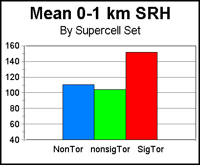
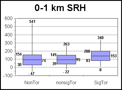
Figure 2. As in Fig. 1 except for 0-1 km SRH in m2s-2.
Combinations of buoyancy and vertical wind shear have gained widespread use as supercell forecasting tools, including CAPE versus SRH diagrams (e.g., Johns et al. 1993, hereafter J93) and BRN. In our scatter diagrams of CAPE and SRH (e.g., 0-3 km layer of Fig. 3), the primary distinction between tornadic and nontornadic supercells was not 0-3 km SRH, but instead, CAPE. The range of SRH was comparable for both subsets; however CAPE above 3.5 kJkg-1 was much more prevalent around tornadic supercells. For the latter, there was a trend toward greater SRH as CAPE decreased, but not as pronounced as found by J93 when they used 0-2 km SRH and CAPE computed without the Tv correction.

Figure 3. CAPE versus 0-3 km SRH, with nontornadic supercells as open circles and tornadic as squares.
Mean BRN for various supercell subsets were between 57 and 78 (Fig. 4). This is well above the simulated supercell range of 10 to 40 (Weisman and Klemp 1982, hereafter WK82), and instead suggest multicell structure. However, direct comparison with the WK82 results is not necessarily viable since BRN is strongly influenced by CAPE. WK82 simulated supercells in environments of CAPE of 1 to 3.5 kJkg-1. In contrast, a substantial fraction (24%) of our observed supercells occurred with surface-based CAPE above the WK82 limit. This suggests that the BRN should be used cautiously as a supercell forecast tool, especially during the warm season when large CAPE is relatively common.

Figure 4. As in Fig. 1a except for mean BRN. The 10-40 range favorable for simulated supercells (Weisman and Klemp 1982) is shaded across the graph.
The mean value of the BRN shear term (WK82) for each subset was over the 40 m2s-2 guideline for supercells as prescribed by WK82: 58 (nontornadic), 55 (weakly tornadic) and 69 (significant tornadic). Box and whiskers plots (not shown) showed very little difference between subsets for the 25th through 75th percentile ranges.

Figure 5. Box and whiskers plot of 0-1 km AGL EHI for nontornadic supercells and significant tornadic supercells (F2-F5 damage).
The Energy-Helicity Index (EHI, Davies 1993) was also tested. As with SRH alone, 0-1 km EHI was used because most of the variation in SRH was found in the lowest 1 km AGL. EHI provided a strong signal as it did in RB98; box and whiskers plots of EHI (Fig. 5) show very little overlap between the 25th-75th percentile ranges for nontornadic and significant tornadic supercells. The combination of EHI was also compared to LCL to determine their combined utility as a significant tornado forecast tool (Fig. 6). Supercells producing significant tornadoes were characterized in the mean by much lower LCL and higher EHI than nontornadic storms. Although there was substantial overlap between the nontornadic and significant tornadic supercells in Fig. 6 for LCL heights less than 1500 m, the primary cluster of nontornadic supercells occurred at lower EHI and greater LCL values than the significant tornadic supercells.
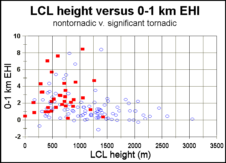
Figure 6. Surface parcel LCL height and 0-1 km EHI, with nontornadic supercells as open circles and significant tornadic supercells as solid squares.
4. FURTHER OBJECTIVES
More supercells are being added continually to our database in an operational setting, expanding the total supercell count past 350 as of this writing. One aim is to build an environmental climatology of supercells which may be analyzed in a great variety of ways. An expanded set of kinematic and thermodynamic variables is planned for testing as well. These include: other storm depth dependent variables such as storm-relative wind in the surface to LFC layer, environmental shear parameters not normalized to storm depth (e.g., 0-6 km shear), combined variables such as the energy-helicity index (Davies 1993), lapse rates, and storm motion prediction techniques
Forecasting supercell motion is especially important to determining tornado potential through storm-relative wind and vertical shear influences, as most recently demonstrated through the methods devised by Bunkers et al. (2000). We will verify their techniques using observed storm motions from this data base, incorporating the presence or absence and nature of observed boundaries as documented with each supercell.
5. REFERENCES
Blanchard, D.O., 1998: Assessing the vertical distribution of convective available potential energy. Wea. Forecasting, 13, 870-877.
Bunkers, M.J., B.A. Klimowski, J.W. Zeitler, R.L. Thompson, and M.L. Weisman, 2000: Predicting supercell motion using a new hodograph technique. Wea. Forecasting, 15, 61-79.
Davies, J.M., 1993: Hourly helicity, instability and EHI in forecasting supercell tornadoes. Preprints, 17th Conf. on Severe Local Storms, St. Louis, Amer. Meteor. Soc., 107-111.
Davies-Jones, R.P., D.W. Burgess and M. Foster, 1990: Test of helicity as a tornado forecast parameter. Preprints, 16th Conf. on Severe Local Storms, Kananaskis Park, AB, Canada, Amer. Meteor. Soc., 588-592.
_____, 1993: Helicity trends in tornado outbreaks. Preprints, 17th Conf. on Severe Local Storms, St. Louis, MO, Amer. Meteor. Soc., 56-60.
Doswell, C.A. III, and E. N. Rasmussen, 1994: The effect of neglecting the virtual temperature correction on CAPE calculations. Wea. Forecasting, 9, 625-629.
Edwards, R., and R.L. Thompson, 1998: Nationwide comparisons of hail size with WSR-88D vertically integrated liquid water and derived thermodynamic sounding data. Wea. Forecasting, 13, 277-285.
Gilmore, M. S., and L. J. Wicker, 1998: The influence of midtropospheric dryness on supercell morphology and evolution. Mon.Wea. Rev., 126, 943-958.
Johns, R. H., J. M. Davies, and P. W. Leftwich, 1993: Some wind and instability parameters associated with strong and violent tornadoes. Part II: Variations in the combinations of wind and instability parameters. The Tornado: Its Structure, Dynamics, Prediction, and Hazards. Geophys. Mongr., 79, Amer. Geophys. Union, 583-590.
Lemon, L. R., and C. A. Doswell III, 1979: Severe thunderstorm evolution and mesocyclone structure as related to tornadogenesis. Mon. Wea. Rev., 107, 1184-1197.
Markowski, P. M., E. N. Rasmussen, and J. M Straka, 1998a: The occurrence of tornadoes in supercells interacting with boundaries during VORTEX-95. Wea. Forecasting, 13, 852-859.
_____, J. M. Straka, E. N. Rasmussen, and D. O. Blanchard, 1998b: Variability of storm-relative helicity during VORTEX. Mon. Wea. Rev., 126, 2959-2971.
Rasmussen, E. N., and D. O. Blanchard, 1998: A baseline climatology of sounding-derived supercell and tornado forecast parameters. Wea. Forecasting, 13, 1148-1164.
Thompson, R.L., and R. Edwards, 2000a: A comparison of Rapid Update Cycle 2 (RUC-2) model soundings with observed soundings in supercell environments. Preprints, 20th Conf. Severe Local Storms, Orlando, Amer. Meteor. Soc. (this volume).
_____. and _____, 2000b: RUC-2 supercell proximity soundings, Part I: An examination of storm-relative winds normalized to supercell depth. Preprints, 20th Conf. Severe Local Storms, Orlando, Amer. Meteor. Soc. (this volume).
Weisman M.L., and J. B. Klemp, 1982: The dependence of numerically simulated convective storms on vertical wind shear and buoyancy. Mon. Wea. Rev., 110, 504-520.