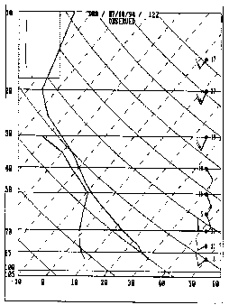
Figure 1. 1200 UTC Desert Rock, Nevada (DRA) sounding on 18 July 1994 illustrating an inverted-V configuration.
PRELIMINARY EVALUATION OF A PCGRIDDS MACRO IN FORECASTING DRY MICROBURSTS OVER THE WESTERN UNITED STATES
and
John R. Mecikalski
University of Wisconsin - Madison
1. Introduction
Increased understanding of the severe storm environment and advances in technology are making it possible to forecast not only severe probability, but a specific severe storm type, well into the future. The recent inclusion of categorical risks in the updated Day 2 Severe Weather Outlook at the Storm Prediction Center (formerly the National Severe Storms Forecast Center), and the "Supercell Index" developed at the University of Wisconsin as employed in their nonhydrostatic operational model (Wilt 1994; G. Tripoli, personal communications), are just two examples of this trend. To date, the atmospheric thermal and dynamic signatures typically identified with the severe storm types over the central and eastern United States (e.g., supercellular, linear) have proven reliable indicators of their occurrence, and are charted daily in the operational workplace. However, an area of the country lacking in a general pattern recognition scheme for the identification of severe storm episodes endemic to its location is the western United States, that area west of the Continental Divide, roughly between the Cascade and Sierra Ranges and 105 degrees W longitude.
The purpose of this study is to develop and present a technique for identifying favorable environments for a particular type of severe storm development over these regions. Specifically, the intent is to show that severe dry microbursts (SDM) can possibly be forecasted with greater accuracy out to 24 hours in advance using data routinely available to the forecaster, namely products from the "Early Eta" Model. Through the use of a macro in the PCGRIDDS software package, the model's data can be efficiently presented as a composite of the most important parameters needed to identify the SDM environment.
2. Background
Dry microbursts, produced by high based thunder-storms that produce little surface rainfall, occur in an environment characterized by a thermodynamic profile exhibiting an "inverted-V" thermal and moisture profile, as viewed on a Skew-T log-P thermodynamic diagram (Figure 1). They can produce very damaging surface winds, despite their relatively benign appearance both visually and on radar screens, and are responsible for much of the observed severe weather on local scales in the western United States (NOAA 1984).
Figure 1. 1200 UTC Desert Rock, Nevada (DRA) sounding on 18 July 1994 illustrating an inverted-V configuration.
Forecasting such events can be difficult as dry microbursts are typically isolated in nature, usually occur in relatively tranquil environments (poorly defined wind fields with little baroclinicity, atypical of many other severe storm types), and the thermal and moisture profiles characteristic of the inverted-V sounding profile are very common over the western United States during the warm season. Current forecast techniques are limited to interpretation of morning radiosonde data, which only provides at best a maximum 12 hour lead time of an event (Wakimoto 1985; Scott 1990). Recognizing the need for an improved forecast method of SDMs, a macro in PCGRIDDS, structured after the conceptual model of Wakimoto (1985; see Figure 2), was designed to effectively present the critical thermodynamic parameters which are necessary for dry microburst development. These parameters are 1) mid level moisture, 2) a deep, dry adiabatic layer in the sub-cloud layer, and 3) low surface relative humidities; the juxtaposition of these parameters implies a favorable dry microburst environment (Figure 3). Through the use of this macro, we have found an improved ability to predict these events with lead times of at least 24 hours.

Figure 2. Model of the characteristics of the morning and evening environmental soundings favorable for dry microburst activity over the High Plains (after Wakimoto, 1985).

Figure 3. 24 hour forecast of dry microburst activity valid at 0000 UTC on 19 July 1994. Thick, solid lines represent boundary layer relative humidity less than 4 with all values labeled in tenths of a percent. Thin, solid lines represent 500 to 400 mb mean relative humidity more than 5 with all values in tenths of a percent. Note the 50 percent mean relative humidity line is denoted by a dashed/dot line. Circled lines indicate 850 to 500 mb temperature differences more than 30 degrees Celsius and contoured every 2 degrees Celsius. Dashed lines represent 700 to 500 mb average vertical velocities with only negative values (implying upward motion) displayed. (Note that actual PCGRIDDS display shows each parameter in different colors to facilitate visual assimilation of data.)
3. Methodology
In order to follow Wakimoto's conceptual model of a dry microburst environment, the specific components utilized to create the dry microburst macro are: 1) the mean relative humidity between 500 and 400 mb, which must be more than 50%, (used to represent mid level moisture), 2) the 850 to 500 mb temperature difference, which must be 30 degrees C or more, (used to infer a nearly dry adiabatic lapse rate), and 3) the boundary layer relative humidity, which must be less than 40% (to represent dry surface air). An added component is the 700 to 500 mb average vertical velocities (UVVs) (which must be negative; upward), required to determine the contribution of dynamical support for general thunderstorm development.
However, examination of real time environ-mental soundings in the western United States during the warm season shows that in many situations, the mid level moisture is commonly found between 600 and 500 mb. Limitations of the Early Eta model preclude the use of this layer as a representation of mid level moisture as 600 mb data is not available in PCGRIDDS. Thus the 500 to 400 mb level moisture was chosen to estimate the existence of mid level moisture as this coincides well with Wakimoto's model.
After constructing the macro, Early Eta model data from 15 May through 15 September 1994 were examined to evaluate its performance. The Storm Prediction Center's (SPC) severe weather log and Storm Data (NOAA) were examined to isolate the occurrence of SDMs (those which produced winds over 50 kts or convective wind damage) in the study area. A total of 64 cases were used, stratified by the number of severe occurrences, either 1-4, or 5 or more, for a given event. As population density and topography both contribute to poor and often incomplete severe weather statistics on any given day over the western United States (McNulty 1981), the choice of cases was certainly influenced by those events which affected larger population centers.
For each of the cases a comparison was made between the 24 hour dry microburst macro forecast, valid at 00 UTC, (hereafter referred to as "24FCST") with the initial zero hour Early Eta analysis fields (hereafter referred to as "00ETA"). An assumption is made that the initial zero hour model analysis is a valid representation of environmental conditions characterizing each dry microburst event.
4. Macro/model evaluation
Five or more SDMs occurred on nine of the 122 days (7 percent) used during the period examined. There were 55 days (45 percent) where one to four SDMs occurred and 58 days (48 percent) had no reports. This data supports the idea that SDM activity is usually isolated in nature and that widespread outbreaks are quite rare.
Since the performance of the macro is rooted in the overall performance of the Early Eta model, we can evaluate this aspect of the macro separate from its ability to identify SDM environments. Average values of each parameter listed above are shown in Table 1, along with standard deviations. While perhaps being the most important element when forecasting SDMs, mid-level relative humidity appears most variable of all quantities. Relatively small variance in the low-level relative humidity confirms the requirement of a dry subcloud layer to support strong descending motions, while strong dynamic forcing is not generally the case given the small average UVVs (~1-1.5 microbars s-1); 850-500 mb temperatures differences are consistently large.
Table 1
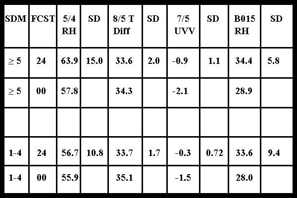
*Note that SDM stands for number of severe dry microbursts, FCST denotes forecast hour of the dry microburst macro, 5/4 RH is the 500 to 400 mb mean relative humidity (in percent), SD is the standard deviation, 8/5 T Diff is the 850 to 500 mb temperature difference (in degrees C), 7/5 UVV is the 700 to 500 mb average vertical velocities (in microbars per second), and B015 RH is the boundary layer relative humidity (in percent). There were nine cases with 5 or more SDMs and 55 cases of 1-4 SDMs.
In addition, a comparison of the 24FCST values with the 00ETA forecast indicates several model biases. These are: 1) higher mid level moisture values at 24FCST than at 00ETA, 2) the 850 to 500 mb temperature differences at 24FCST are forecast well, typically within a degree of the 00ETA values, and 3) boundary layer relative humidities at 24FCST are somewhat higher than at 00ETA, however, when comparing the actual temperature/dew point depression at 24FCST with the 00ETA forecast, values were often underforecast by 6 to 8� C. In addition, 700 to 500 mb UVVs tended to be underforecasted at 24FCST when compared to the 00ETA forecast.
In those cases characterized by more intense dynamic patterns, which usually produced five or more SDMs, the Early Eta model appears to provide a better forecast in the juxtaposition of the macro parameters compared to cases when little dynamic forcing was present to enhance dry microburst activity. The stronger dynamic cases occurred when a well defined short wave trough moved into a favorable dry microburst environment.
5. Case example: 18 July 1994
Figure 3 shows the macro output for the 24FCST made on 18 July 1994. All components of the macro are favorably positioned (80-90 percent mid level mean relative humidity, 34-36 degrees Celsius 850 to 500 mb temperature differences, 20-30 percent boundary layer relative humidity, and weak upward vertical velocities) across portions of central and southern Nevada, extreme northwest Arizona, and southwest Utah. The 12 UTC 18 July 1994 sounding taken at Desert Rock, Nevada (DRA), shown in Figure 1, indicates an inverted-V profile as does the 12 UTC sounding at Ely, Nevada (not shown). In this case however, a well defined upper circulation was observed in satellite imagery (not shown) moving into the southern portions of Nevada and Utah denoting increased dynamic support for convection later in the day. By afternoon, a large area of thunderstorms developed into portions of Utah and Nevada. Numerous SDMs were reported in southwest Utah and southern Nevada (Figure 4); 60 to 80 kt winds produced substantial damage in southern Nevada.

Figure 4. Plot of all severe weather reports from 0600 UTC, 18 July 1994 to 0600 UTC, 19 July 1994. Crosses delineate reports of damaging winds and/or wind gusts greater than or equal to 50 knots.
The 00ETA forecast at 00 UTC 19 July 1994 is shown in Figure 5. Although the SDM components are not as well defined as in the 24FCST, use of the macro in making the 24 hour forecast allowed for a critical evaluation of this case well before severe conditions existed. This helped draw the attention of SPC forecasters to this region, prompting the issuance of a slight risk of severe thunderstorms on the 15 UTC convective outlook and a timely watch issued later in the day. The macro helped save time and increase forecaster efficiency in the evaluation of this event.

Figure 5. Same as Figure 3 but initial forecast valid at 0000 UTC 19 July 1994.
6. Forecast Implications and Conclusions
The dry microburst macro was utilized at the SPC during the 1994 warm season with some degree of success. Although the 24FCST was not routinely utilized to make forecasts of SDMs in the 07 UTC "Day 1" Convective Outlook, output from the 24FCST was combined with morning model and radiosonde data to update forecasts of SDMs in the 1500 and 1930 UTC "Day 1" Convective Outlooks.
Despite the fact that forecasts of mid-level moisture at 24FCST were somewhat overdone when compared to the 00ETA data, the relative location of the moisture in SDM events appears to be well forecast in most situations. Since SDM events appear most sensitive to mid-level moisture, this is one component of the macro we intend to better define with the macros continued use. For example, 50% mean relative humidity in the 500 to 400 mb layer is a reputable delineator when making thunderstorm assessment in the western United States.
Another shortcoming of the Early Eta model includes its poor ability to forecast SDM parameters on days with weak or nonexistent dynamic forcing (which were typically days when few (1-4) SDM reports were received). As seen in Table 1, little distinction can be made between days of 5 or more reports and days with fewer SDMs perhaps indicating that more SDM parameters are needed to distinguish between weak and strong events.
As alluded to above, further testing is needed since only two warm seasons have past since macro development. Also, given the limitations of the PCGRIDDS data resolution in describing the dry microburst environment, use of another model's data may be necessary. Utilization of model data output with better resolution, particularly N-AWIPS (i.e. vertical resolution of 50 mb is available in the Eta and 25 mb resolution in the Meso Eta and Rapid Update Cycle) will be examined.
7. Acknowledgements
The authors would like to thank Steve Weiss (SPC) for his valuable input and interest in this project.
8. References
NOAA, 1984: Severe thunderstorms - Western style, Part I. Western Region Technical Attachment No. 84-15.
Scott, C. A., 1990: The Las Vegas McCarran International Airport Microburst of August 8, 1989. NOAA Technical Memorandum NWS WR-207, U. S. Department of Commerce, National Weather Service Western Region.
Wakimoto, R. M., 1985: Forecasting dry microburst activity over the High Plains. Mon. Wea. Rev., 113, 1131-1143.
Wilt, B. A., 1994: Supercell Index: Prediction of supercells and tornadoes with model output diagnostics. Masters Thesis, University of Wisconsin, 110 pages.