Storm Prediction Center Day 1 Fire Weather Outlook
Created: Mon May 28 15:22:02 UTC 2018 (
![]() |
| ![]() )
)
|
Click for Day 1 FireWX Areal Outline Product
ZCZC SPCFWDDY1 ALL
FNUS21 KWNS 281520
Day 1 Fire Weather Outlook
NWS Storm Prediction Center Norman OK
1020 AM CDT Mon May 28 2018
Valid 281700Z - 291200Z
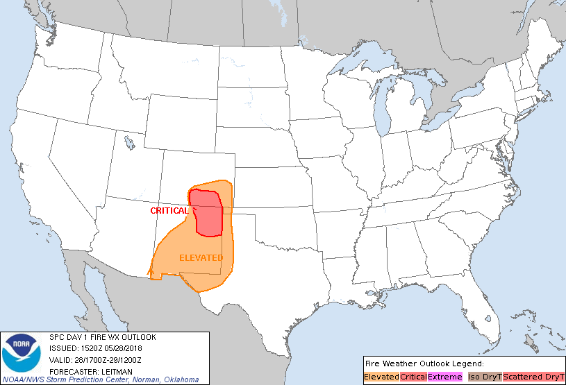
...CRITICAL FIRE WEATHER AREA FOR PORTIONS OF SOUTHEAST COLORADO AND
NORTHEAST NEW MEXICO...
The critical area has been trimmed to remove far southeast CO.
Available fuel status information suggests fuels are not supportive
of large fires across this region. Additionally, cool north winds as
far south as the Arkansas River are maintaining dewpoints in the mid
50s to low 60s and how much mixing may occur is unclear. Other minor
adjustments have been made on the eastern edge of the elevated area
to better reflect forecast position of the surface dryline and
expected afternoon thunderstorm development. See previous discussion
below for more details on expected conditions across the critical
and elevated areas.
..Leitman.. 05/28/2018
.PREV DISCUSSION... /ISSUED 0152 AM CDT Mon May 28 2018/
...Synopsis...
An upper low centered over the Great Basin early this morning will
develop slowly northeastward today. Enhanced mid-level flow of 30-40
kt will persist across parts of the Southwest and southern/central
High Plains through this afternoon. At the surface, a low will
remain over eastern CO, with a dryline extending southward from this
low across the southern High Plains.
...Portions of the Southwest and Southern/Central Plains...
Strong/gusty southerly to southwesterly winds around 20-30 mph will
likely develop this afternoon across a small part of northeastern NM
into southern/eastern CO as the enhanced mid-level winds mentioned
previously become diurnally mixed to the surface. Some enhancement
to the surface pressure gradient will also exist across this region.
Behind the surface dryline, RH values will easily fall below 15% as
a very dry low-level airmass becomes well mixed. A relatively narrow
overlap of strong/gusty winds with RH values of 5-15% appears likely
this afternoon across northeastern NM and parts of southern/eastern
CO, where a critical area has been maintained with generally minor
changes. Elevated fire-weather conditions will occur across a
broader portion of NM into the western TX/OK Panhandles and
southeastern CO. But, marginal forecast wind speeds of 15-20 mph
should preclude more widespread critical conditions across this
region. The eastward extent of elevated fire-weather conditions will
also be constrained by the surface dryline, which will likely not
make much eastward progress through peak heating.
...Please see www.spc.noaa.gov/fire for graphic product...