|
20140219's Storm Reports (1200 UTC - 1159 UTC) (Print Version)
|
< 140218 Reports
140220 Reports >
|
| Note: All Reports Are Considered Preliminary |
|
|
|
|

| Tornado Reports (CSV) (Raw Tornado CSV)(?) |
|---|
| No reports received |
| Hail Reports (CSV) (Raw Hail CSV)(?) |
|---|
Time | Size | Location | County | State | Lat | Lon | Comments |
| 2315 | 100 | 2 WSW PAOLA | MIAMI | KS | 3857 | 9490 | NEIGHBOR ALSO HAD NICKELS (EAX) |
| 1026 | 100 | 2 W JARBALO | LEAVENWORTH | KS | 3920 | 9510 | (EAX) |
| 1045 | 150 | 3 N GLADSTONE | CLAY | MO | 3926 | 9456 | PICTURE POSTED ON SOCIAL MEDIA FROM PUBLIC (EAX) |
| 1054 | 100 | 1 N PLATTE WOODS | PLATTE | MO | 3924 | 9465 | HAIL UP TO QUARTER SIZE COVERING THE GROUND NEAR ZONA ROSA (EAX) |
| 1055 | 150 | 5 N GLADSTONE | CLAY | MO | 3929 | 9454 | NEAR STALEY HIGH SCHOOL IN KC NORTH (EAX) |
| 1058 | 100 | 4 N GLADSTONE | CLAY | MO | 3927 | 9456 | (EAX) |
| Wind Reports (CSV) (Raw Wind CSV)(?) |
|---|
Time | Speed | Location | County | State | Lat | Lon | Comments |
| 1220 | UNK | 2 NNW FAUST | MADISON | NC | 3594 | 8254 | MULTIPLE TREES DOWN NEAR WOLF RIDGE SKI RESORT. (GSP) |
| 0726 | UNK | 1 ESE CHALMETTE | ST. BERNARD | LA | 2994 | 8995 | SEVERAL HOUSES EXPERIENCED THUNDERSTORM WIND DAMAGE IN THE MEREAUX AREA ... PRIMARILY ALONG JUDY DRIVE. DAMAGE WAS MAINLY TO ROOFING MATERIAL REMOVED ... A FEW WINDOWS BLOW (LIX) |
| 0732 | UNK | VIOLET | ST. BERNARD | LA | 2990 | 8989 | SEVERAL HOUSES IN THE VIOLET AREA ... PRIMARILY ALONG 6TH STREET ... EXPERIENCED THUNDERSTORM WIND DAMAGE. PRIMARY IMPACT WAS SHINGLES ... AND ROOFING MATERIAL REMOVED ... AND (LIX) |
|
| Filtered Tornado Reports (CSV) (Raw Tornado CSV)(?) |
|---|
| No reports received |
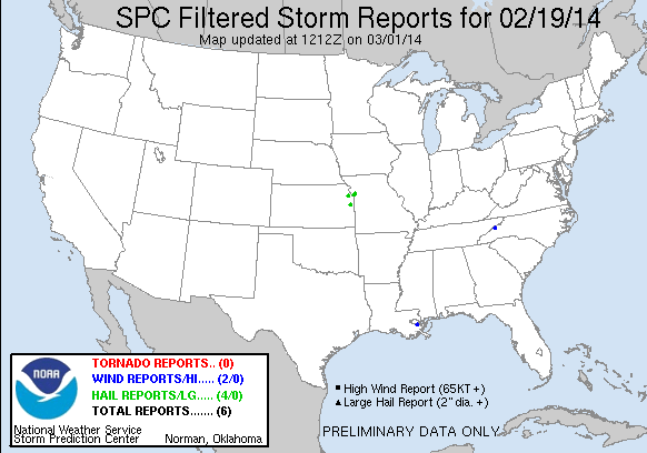
| Filtered Hail Reports (CSV) (Raw Hail CSV)(?) |
|---|
Time | Size | Location | County | State | Lat | Lon | Comments |
| 2315 | 100 | 2 WSW PAOLA | MIAMI | KS | 3857 | 9490 | NEIGHBOR ALSO HAD NICKELS (EAX) |
| 1026 | 100 | 2 W JARBALO | LEAVENWORTH | KS | 3920 | 9510 | (EAX) |
| 1054 | 100 | 1 N PLATTE WOODS | PLATTE | MO | 3924 | 9465 | HAIL UP TO QUARTER SIZE COVERING THE GROUND NEAR ZONA ROSA (EAX) |
| 1055 | 150 | 5 N GLADSTONE | CLAY | MO | 3929 | 9454 | NEAR STALEY HIGH SCHOOL IN KC NORTH (EAX) |
| Filtered Wind Reports (CSV) (Raw Wind CSV)(?) |
|---|
Time | Speed | Location | County | State | Lat | Lon | Comments |
| 1220 | UNK | 2 NNW FAUST | MADISON | NC | 3594 | 8254 | MULTIPLE TREES DOWN NEAR WOLF RIDGE SKI RESORT. (GSP) |
| 0726 | UNK | 1 ESE CHALMETTE | ST. BERNARD | LA | 2994 | 8995 | SEVERAL HOUSES EXPERIENCED THUNDERSTORM WIND DAMAGE IN THE MEREAUX AREA ... PRIMARILY ALONG JUDY DRIVE. DAMAGE WAS MAINLY TO ROOFING MATERIAL REMOVED ... A FEW WINDOWS BLOW (LIX) |
| Full report in comma-separated values (CSV) format and in KML format. |
| Full filtered report in comma-separated values (CSV) format and in KML format. |
| KML files are created with time-enabled placemarks compatible with Google Earth Time Slider. |
| Raw full report in comma-separated values (CSV) format |
| Fields marked UNK are unknown |
| All Times UTC |
| Wind Gusts in MPH |
| Hail Sizes in 1/100 of an Inch (175 = 1.75") |
| LAT/LON in decimal degrees to two decimals, see SPC FAQ for more info |
| List of Weather Forecast Office 3-letter IDs appear in the report comments section |
|
|
|
Top/Storm Reports/Home
|
|
|


 @NWSSPC