|
20180511's Storm Reports (20180511 1200 UTC - 20180512 1159 UTC) (Print Version)
|
< 180510 Reports
180512 Reports >
|
| Note: All Reports Are Considered Preliminary |
|
|
|
|
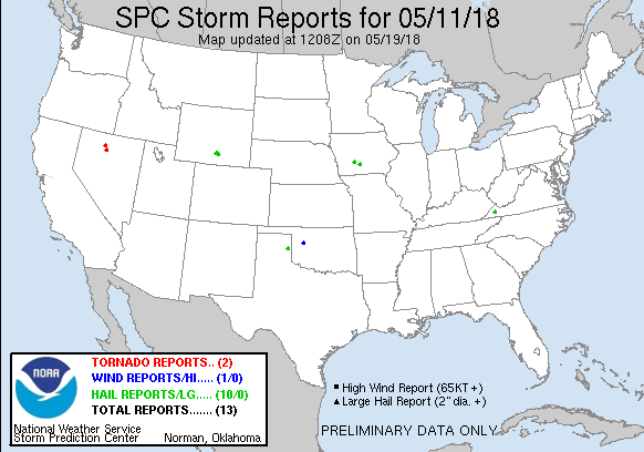
| Tornado Reports (CSV) (Raw Tornado CSV)(?) |
|---|
Time | | Location | County | State | Lat | Lon | Comments |
| 1805 | | 10 SE GOLCONDA | HUMBOLDT | NV | 4084 | 11734 | SPOTTER SAW THE FUNNEL CLOUD PICKING UP DEBRIS FROM THE GROUND IN AN OPEN FIELD. THE ESTIMATED WIDTH OF THE TORNADO WAS APPROXIMATELY 25 YARDS. THIS OCCURRED IN A RURAL (LKN) |
| 1925 | | 14 N GOLCONDA | HUMBOLDT | NV | 4115 | 11752 | SPOTTER SAW TORNADO TOUCH DOWN AND WENT OVER DIRT ROAD. TORNADO WENT BACK UP INTO CLOUD QUICKLY. OCCURRED IN A RURAL LOCATION WITH NO DAMAGE. (LKN) |
| Hail Reports (CSV) (Raw Hail CSV)(?) |
|---|
Time | Size | Location | County | State | Lat | Lon | Comments |
| 1842 | 100 | CLEVELAND | RUSSELL | VA | 3694 | 8215 | QUARTER SIZE HAIL (MRX) |
| 2334 | 100 | RAWLINS | CARBON | WY | 4178 | 10723 | (CYS) |
| 2335 | 125 | 1 N RAWLINS | CARBON | WY | 4180 | 10723 | SOME UP TO PING PONG SIZE. (CYS) |
| 2339 | 100 | RAWLINS | CARBON | WY | 4178 | 10723 | (CYS) |
| 2346 | 175 | RAWLINS | CARBON | WY | 4178 | 10723 | (CYS) |
| 2349 | 125 | N SINCLAIR | CARBON | WY | 4178 | 10712 | BROKEN CAR WINDOWS AND DAMAGE TO SHINGLES. (CYS) |
| 0006 | 100 | 1 N WHEELER | WHEELER | TX | 3545 | 10028 | (AMA) |
| 0015 | 175 | 5 E SINCLAIR | CARBON | WY | 4178 | 10702 | HAIL CAUSED DAMAGE TO HIS CAR. LARGE DENTS (CYS) |
| 0704 | 100 | 1 NNE STUART | GUTHRIE | IA | 4151 | 9431 | REPORT VIA SOCIAL MEDIA. TIME ESTIMATED BY RADAR. (DMX) |
| 0830 | 100 | SAINT MARYS | WARREN | IA | 4131 | 9373 | REPORT VIA SOCIAL MEDIA. TIME ESTIMATED BY RADAR. (DMX) |
| Wind Reports (CSV) (Raw Wind CSV)(?) |
|---|
Time | Speed | Location | County | State | Lat | Lon | Comments |
| 0220 | 62 | 3 N PUTNAM | DEWEY | OK | 3590 | 9897 | HEAT BURST. (OUN) |
|
| Filtered Tornado Reports (CSV) (Raw Tornado CSV)(?) |
|---|
Time | | Location | County | State | Lat | Lon | Comments |
| 1805 | | 10 SE GOLCONDA | HUMBOLDT | NV | 4084 | 11734 | SPOTTER SAW THE FUNNEL CLOUD PICKING UP DEBRIS FROM THE GROUND IN AN OPEN FIELD. THE ESTIMATED WIDTH OF THE TORNADO WAS APPROXIMATELY 25 YARDS. THIS OCCURRED IN A RURAL (LKN) |
| 1925 | | 14 N GOLCONDA | HUMBOLDT | NV | 4115 | 11752 | SPOTTER SAW TORNADO TOUCH DOWN AND WENT OVER DIRT ROAD. TORNADO WENT BACK UP INTO CLOUD QUICKLY. OCCURRED IN A RURAL LOCATION WITH NO DAMAGE. (LKN) |
| Filtered Hail Reports (CSV) (Raw Hail CSV)(?) |
|---|
Time | Size | Location | County | State | Lat | Lon | Comments |
| 1842 | 100 | CLEVELAND | RUSSELL | VA | 3694 | 8215 | QUARTER SIZE HAIL (MRX) |
| 2346 | 175 | RAWLINS | CARBON | WY | 4178 | 10723 | (CYS) |
| 0006 | 100 | 1 N WHEELER | WHEELER | TX | 3545 | 10028 | (AMA) |
| 0015 | 175 | 5 E SINCLAIR | CARBON | WY | 4178 | 10702 | HAIL CAUSED DAMAGE TO HIS CAR. LARGE DENTS (CYS) |
| 0704 | 100 | 1 NNE STUART | GUTHRIE | IA | 4151 | 9431 | REPORT VIA SOCIAL MEDIA. TIME ESTIMATED BY RADAR. (DMX) |
| 0830 | 100 | SAINT MARYS | WARREN | IA | 4131 | 9373 | REPORT VIA SOCIAL MEDIA. TIME ESTIMATED BY RADAR. (DMX) |
| Filtered Wind Reports (CSV) (Raw Wind CSV)(?) |
|---|
Time | Speed | Location | County | State | Lat | Lon | Comments |
| 0220 | 62 | 3 N PUTNAM | DEWEY | OK | 3590 | 9897 | HEAT BURST. (OUN) |
| The Storm Reports page is organized based on reports received from 1200 UTC to 1159 UTC the next day. For example, storm report page for 20150430 covers reports from 20150430 at 1200 UTC to 20150501 at 1159 UTC. |
| Full report in comma-separated values (CSV) format and in KML format. |
| Full filtered report in comma-separated values (CSV) format and in KML format. |
| KML files are created with time-enabled placemarks compatible with Google Earth Time Slider. |
| Raw full report in comma-separated values (CSV) format. |
| Fields marked UNK are unknown. |
| All Times UTC. |
| Wind Gusts in MPH. |
| Hail Sizes in 1/100 of an Inch (175 = 1.75") |
| LAT/LON in decimal degrees to two decimals, see SPC FAQ for more info. |
| List of Weather Forecast Office 3-letter IDs appear in the report comments section. |
|
|
|
Top/Storm Reports/Home
|
|
|


 @NWSSPC