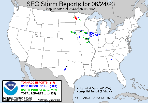
| Tornado Reports (CSV) (Raw Tornado CSV)(?) |
|---|
Time | | Location | County | State | Lat | Lon | Comments |
| 2020 | | 3 N Lake Park | Becker | MN | 4693 | 9610 | WDAY Broadcaster sent us photos of tornado still moving. (FGF) |
| 2020 | | 6 W Callaway | Becker | MN | 4698 | 9604 | Met sent us tornado picture via twitter 6 W of Callaway. (FGF) |
| 2030 | | 6 W Ada | Norman | MN | 4730 | 9664 | Spotter confirms tornado near ADA with picture via twitter. (FGF) |
| 2057 | | 3 S Flom | Becker | MN | 4712 | 9613 | Corrects previous tornado report from 3 S Flom. Hunter Anderson reports touchdown near Flom. (FGF) |
| 2059 | | Ada | Norman | MN | 4730 | 9651 | Public confirms tornado with picture via twitter. (FGF) |
| 2100 | | 2 ENE Mahnomen | Mahnomen | MN | 4733 | 9593 | Trees damaged. (FGF) |
| 2105 | | 5 NW Borup | Norman | MN | 4723 | 9658 | Tornado touchdown near Borup. (FGF) |
| 2115 | | 3 E Shelly | Norman | MN | 4746 | 9676 | Norman EM reported Touchdown near Shelly heading N-NW. (FGF) |
| 2125 | | 4 NW Lockhart | Norman | MN | 4748 | 9661 | Tornado confirmed near lockhart and went through tree grove Norman EM was going to survey for damage. (FGF) |
| 2130 | | 2 E Mahnomen | Mahnomen | MN | 4730 | 9593 | Corrects previous tornado report from 2 ESE Mahnomen. Reported Barn Damage from Tornado 47.314827 ... -95.931726. (FGF) |
| 2138 | | 2 ENE Mahnomen | Mahnomen | MN | 4733 | 9593 | Corrects previous tornado report from 2 ENE Mahnomen. Trees damaged. (FGF) |
| 2152 | | 5 W Waubun | Mahnomen | MN | 4718 | 9605 | Hunter anderson clalled about tornado with intermittent touchdowns near Waubun. (FGF) |
| 2152 | | 4 NW Beltrami | Polk | MN | 4758 | 9659 | Spotter mick elm called about 2 Tornadoes forming from one with multiple vortices n. (FGF) |
| 2157 | | 3 S Flom | Becker | MN | 4712 | 9613 | H.Anderson reports touchdown near Flom. (FGF) |
| 2159 | | 5 WSW Beltrami | Polk | MN | 4752 | 9663 | Whitehill Reports another touchdown near Beltrami via NWSchat. (FGF) |
| 2230 | | 2 ESE Mahnomen | Mahnomen | MN | 4730 | 9593 | Reported Barn Damage from Tornado 47.309370 ... -95.933522. (FGF) |
| 0331 | | 3 S Maysville | Scott | IA | 4161 | 9071 | A tornado developed about 2 miles east of Walcott along Interstate 80. The tornado tracked east and caused sporadic minor tree and structure damage at the Northwest Bou (DVN) |
| Hail Reports (CSV) (Raw Hail CSV)(?) |
|---|
Time | Size | Location | County | State | Lat | Lon | Comments |
| 1930 | 100 | Indianola | Warren | IA | 4136 | 9356 | Relayed from NWSchat. (DMX) |
| 1931 | 175 | Indianola | Warren | IA | 4136 | 9357 | Delayed report with time estimated. Via KCCI viewer. (DMX) |
| 2053 | 100 | 2 NE Lake Andes | Charles Mix | SD | 4317 | 9851 | (FSD) |
| 2057 | 100 | 1 WNW Ravinia | Charles Mix | SD | 4314 | 9845 | (FSD) |
| 2100 | 100 | Hansell | Franklin | IA | 4276 | 9310 | Largest stone were quarter sized. (DMX) |
| 2100 | 100 | Ravinia | Charles Mix | SD | 4314 | 9843 | (FSD) |
| 2110 | 125 | 2 N Wagner | Charles Mix | SD | 4311 | 9830 | Photo of large hail in persons hand via social media. Time estimated from radar. (FSD) |
| 2122 | 150 | 4 N Dante | Charles Mix | SD | 4309 | 9818 | Hail up to the size of walnuts and heavy rain. (FSD) |
| 2132 | 125 | 6 NE Dante | Bon Homme | SD | 4309 | 9809 | (FSD) |
| 2137 | 100 | Mahnomen | Mahnomen | MN | 4731 | 9597 | Valley News Broadcaster reports quarter size hail in Mahnomen. (FGF) |
| 2142 | 100 | Verdel | Knox | NE | 4281 | 9819 | Nickel to Quarter size hail repoirted. (OAX) |
| 2152 | 125 | 2 WNW Niobrara | Knox | NE | 4277 | 9807 | Lots of quarter to half dollar size hail at Niobrara State Park with wind gusts estimated at 45 mph. (OAX) |
| 2155 | 100 | 1 WSW Waverly | Bremer | IA | 4272 | 9249 | Report from mPING: Quarter (1.00 in.). (DMX) |
| 2159 | 100 | 1 N Blakesburg | Wapello | IA | 4098 | 9264 | Report from mPING: Quarter (1.00 in.). (DMX) |
| 2200 | 125 | 6 SW Springfield | Bon Homme | SD | 4279 | 9796 | (FSD) |
| 2202 | 100 | Blakesburg | Wapello | IA | 4096 | 9264 | At least quarter sized hail. Flag pole snapped in front yard. (DMX) |
| 2204 | 100 | 1 E Blakesburg | Wapello | IA | 4096 | 9262 | (DMX) |
| 2208 | 100 | 2 S Aredale | Butler | IA | 4280 | 9301 | Report from mPING: Quarter (1.00 in.). (DMX) |
| 2216 | 125 | 5 WSW Ottumwa | Wapello | IA | 4099 | 9251 | via Spotternetwork.org. (DMX) |
| 2216 | 100 | Walnut | Pottawattamie | IA | 4148 | 9522 | Quarter size hail. (OAX) |
| 2220 | 100 | 3 SW Westgate | Fayette | IA | 4274 | 9203 | (ARX) |
| 2222 | 100 | 2 SSW Ottumwa | Wapello | IA | 4099 | 9243 | Report from mPING: Quarter (1.00 in.). (DMX) |
| 2225 | 250 | 3 SSE Ottumwa | Wapello | IA | 4099 | 9240 | (DMX) |
| 2226 | 100 | 1 S Ottumwa | Wapello | IA | 4101 | 9242 | (DMX) |
| 2243 | 100 | 5 E Utica | Yankton | SD | 4298 | 9739 | Photo of quarter sized hail in persons hand via social media. Time estimated from radar. (FSD) |
| 2257 | 100 | 1 SE Eldon | Wapello | IA | 4090 | 9220 | Report from mPING: Quarter (1.00 in.). (DMX) |
| 2310 | 125 | 2 SSE Selma | Van Buren | IA | 4083 | 9214 | Report/video from Twitter ... hail of quarter to half dollar size. (DVN) |
| 2315 | 150 | 2 NNW Douds/Leando | Van Buren | IA | 4086 | 9209 | Report from mPING. (DVN) |
| 2317 | 175 | 2 NNE Douds/Leando | Van Buren | IA | 4086 | 9208 | Report from mPING. (DVN) |
| 2318 | 100 | Mayville | Traill | ND | 4750 | 9733 | Spotter called and reported Quarter sized hail dropping and lightning 8 miles away. (FGF) |
| 2325 | 125 | 3 NW Kilbourn | Van Buren | IA | 4084 | 9201 | (DVN) |
| 2325 | 100 | 2 N Portland | Traill | ND | 4753 | 9737 | Facebook picture. (FGF) |
| 2327 | 100 | 7 NE Coleridge | Cedar | NE | 4257 | 9709 | (OAX) |
| 2355 | 100 | 10 S Alcester | Union | SD | 4288 | 9664 | In addition to hail up to the size of quarters for a few minutes ... some strong winds cut up the corn a bit ... but 1.25 inch of rain was wonderful. (FSD) |
| 0018 | 100 | 5 SW Nevis | Hubbard | MN | 4691 | 9491 | Hail up to quarter size in addition to estimated 40 to 50 mph winds at Big Timber Lodge. Time estimated from radar. (FGF) |
| 0037 | 100 | 3 ESE Lowell | Des Moines | IA | 4081 | 9139 | (DVN) |
| 0052 | 100 | 1 E Quincy | Adams | IL | 3993 | 9137 | (LSX) |
| 0052 | 175 | Quincy | Adams | IL | 3994 | 9139 | (LSX) |
| 0056 | 150 | 1 SSW Quincy | Adams | IL | 3991 | 9140 | Via Facebook with picture included. Quarter shown for scale. (LSX) |
| 0056 | 200 | 1 W Quincy | Adams | IL | 3994 | 9141 | Via Twitter with picture included. Hail size estimated from picture. (LSX) |
| 0056 | 200 | Quincy | Adams | IL | 3994 | 9140 | Via Twitter with picture included. Hail size estimated from picture. (LSX) |
| 0059 | 125 | Quincy | Adams | IL | 3994 | 9140 | Via Twitter with picture included. Hail size estimated from picture. (LSX) |
| 0101 | 150 | 6 WNW Shelbina | Shelby | MO | 3972 | 9215 | Via Facebook. Delayed report. (LSX) |
| 0102 | 175 | 6 WNW Shelbina | Shelby | MO | 3972 | 9215 | Pictures via Twitter. Hail fell in Lentner. (LSX) |
| 0102 | 100 | Quincy | Adams | IL | 3994 | 9140 | Via Twitter with picture included. Quarter shown in picture for scale. (LSX) |
| 0128 | 100 | 1 S Emden | Shelby | MO | 3979 | 9186 | Reported quarter sized hail falling. (LSX) |
| 0130 | 100 | 1 S Emden | Shelby | MO | 3979 | 9186 | Report via Facebook of quarter sized hail in Emden. (LSX) |
| 0132 | 100 | Biscay | McLeod | MN | 4483 | 9427 | (MPX) |
| 0140 | 150 | 1 NNE Hannibal | Marion | MO | 3972 | 9138 | Report 1 inch to 1.5 inch hail falling just north of Hannibal proper. (LSX) |
| 0220 | 100 | Argyle | Lee | IA | 4053 | 9157 | Delayed report via social media. (DVN) |
| 0227 | 100 | 6 S Grape Creek | Tom Green | TX | 3150 | 10055 | Report from facebook. 10-15 minutes of hail in Buffalo Heights with very strong winds. (SJT) |
| 0228 | 125 | 5 W Wesley | Kossuth | IA | 4308 | 9409 | Public report from east of Algona on Highway 18. Location estimated from radar. (DMX) |
| 0228 | 100 | 7 WSW Pine River | Cass | MN | 4668 | 9453 | Hail for up to 30 minutes. Mostly around a half inch in size ... but a few were up to the size of quarters. Time estimated from radar. (DLH) |
| 0238 | 100 | 2 S Hull | Pike | IL | 3968 | 9121 | Caller reported 1 inch hail south of Hull. (LSX) |
| 0259 | 100 | 4 NW Truesdale | Buena Vista | IA | 4276 | 9525 | Quarter size hail resulted in roughly 200 strikes to a sheriff deputy squad car. Another nearby deputys house was damaged by hail. Time estimated by radar. (FSD) |
| 0318 | 100 | 5 N Alta | Buena Vista | IA | 4274 | 9530 | Picture sent to NWS with coin reference. (FSD) |
| 0326 | 125 | 2 ESE Truesdale | Buena Vista | IA | 4272 | 9515 | Law enforcement reported half-dollar size hail with very heavy rain and high winds. Time estimated from radar. (FSD) |
| 0352 | 175 | Emmetsburg | Palo Alto | IA | 4311 | 9468 | Law enforcement reports golf ball sized hail falling in Emmetsburg. (DMX) |
| 0355 | 175 | Emmetsburg | Palo Alto | IA | 4311 | 9467 | Leaf damage to trees around town. Some branches downed as well. Delayed report. (DMX) |
| 0355 | 250 | Emmetsburg | Palo Alto | IA | 4311 | 9468 | Law enforcement relayed a report of nearly baseball sized hail in Emmetsburg. Delayed report. Time estimated. (DMX) |
| 0400 | 100 | Cylinder | Palo Alto | IA | 4309 | 9455 | Reported by Trained Spotter. (DMX) |
| 0400 | 300 | 3 WNW Cylinder | Palo Alto | IA | 4310 | 9461 | Media relayed report of measured 3 inch stone west of Cylinder. Delayed report. Time and location estimated from radar. (DMX) |
| 0404 | 175 | 1 N Cylinder | Palo Alto | IA | 4310 | 9455 | Golf ball size hail intermixed with quarter sized hail now north of Cylinder. (DMX) |
| 0545 | 150 | 2 SSE Waterloo | Black Hawk | IA | 4247 | 9234 | Minor leaf damage ... shredded leaves. (DMX) |
| 0548 | 175 | 1 SE Waterloo | Black Hawk | IA | 4248 | 9234 | Report from mPING: Golf Ball (1.75 in.). (DMX) |
| 0549 | 150 | Cedar Falls | Black Hawk | IA | 4252 | 9245 | Trained spotter reports measured 1.5 inch diameter hail in Cedar Falls. (DMX) |
| 0550 | 150 | Waterloo | Black Hawk | IA | 4249 | 9235 | (DMX) |
| 0552 | 175 | 2 SW Waterloo | Black Hawk | IA | 4247 | 9237 | (DMX) |
| 0555 | 300 | 1 SW Evansdale | Black Hawk | IA | 4245 | 9230 | (DMX) |
| 0555 | 275 | 2 SSW Waterloo | Black Hawk | IA | 4247 | 9237 | From KWWL TV viewer. (DMX) |
| 0600 | 150 | 1 NW Gilbertville | Black Hawk | IA | 4243 | 9223 | Shredded leaves from hail. Delayed report. (DMX) |
| 0600 | 175 | Evansdale | Black Hawk | IA | 4246 | 9228 | Forwarded by KWWL TV. (DMX) |
| 0600 | 125 | Elk Run Heights | Black Hawk | IA | 4247 | 9225 | (DMX) |
| 0603 | 175 | 3 SW Waterloo | Black Hawk | IA | 4246 | 9239 | Report from mPING: Golf Ball (1.75 in.). (DMX) |
| Wind Reports (CSV) (Raw Wind CSV)(?) |
|---|
Time | Speed | Location | County | State | Lat | Lon | Comments |
| 1406 | UNK | 1 NE Ames | Story | IA | 4203 | 9361 | Tree branch fell on car parked in street. Report relayed by WHO media via social media. Time estimated by radar. (DMX) |
| 2144 | UNK | 3 S Janesville | Black Hawk | IA | 4260 | 9246 | Tree uprooted and damaged along Waverly Rd. Gazebo damaged. From KWWL TV. Time estimated by radar. (DMX) |
| 2213 | UNK | 3 NNW Marne | Cass | IA | 4149 | 9513 | Power lines down and debris along Boston Rd. Delayed report. (DMX) |
| 2223 | UNK | 2 W Marne | Cass | IA | 4145 | 9515 | Social media report of multiple large branches downed on road 2 miles west of Marne. (DMX) |
| 2235 | UNK | Fairbank | Buchanan | IA | 4264 | 9205 | Several large tree branches 6 inches in diameter blown down and blocking a driveway. The location was 2 miles west of Fairbank. Time estimated by radar. Delayed report. (DVN) |
| 2238 | UNK | Oelwein | Fayette | IA | 4268 | 9192 | 1 tree down and 1 large branch down near vicinity of 1st St NW ... 2nd Ave NW ... and Charles St W. (ARX) |
| 2305 | UNK | 2 SSE Wakonda | Clay | SD | 4298 | 9708 | Social media photo of a heavily damaged barn and trees split 3.5 miles south of Wakonda ... SD. (FSD) |
| 2358 | UNK | Houghton | Lee | IA | 4078 | 9161 | Couple trees downed and some siding damage. Time estimated using radar. (DVN) |
| 0037 | UNK | 3 SE Lowell | Des Moines | IA | 4081 | 9139 | 4 to 5 inch tree limbs down along with lots of small branches. (DVN) |
| 0040 | UNK | Troy Mills | Linn | IA | 4228 | 9168 | Social media pic posted by media of damaged outbuilding and corn bin. Time estimated by RADAR. (DVN) |
| 0046 | UNK | Hannibal | Marion | MO | 3970 | 9138 | Report of tree fallen on house ... no significant damage. (LSX) |
| 0106 | UNK | Dyersville | Dubuque | IA | 4248 | 9112 | large tree limb down. (DVN) |
| 0110 | 75 | 4 N Merkel | Taylor | TX | 3252 | 10000 | (SJT) |
| 0135 | UNK | Merkel | Taylor | TX | 3247 | 10001 | Power lines down in the city of Merkel. Time estimated on radar. (SJT) |
| 0139 | UNK | 3 WSW Georgetown | Grant | WI | 4262 | 9054 | A few trees and large limbs downed. (ARX) |
| 0141 | UNK | Durango | Dubuque | IA | 4256 | 9078 | Large tree fell across Highway 3. (DVN) |
| 0144 | UNK | 1 S Bagley | Clearwater | MN | 4751 | 9540 | Corrects previous tstm wnd dmg report from 1 S Bagley. Small tree downed in addition to pea sized hail and very heavy rain. Time estimated from radar. (FGF) |
| 0150 | UNK | Tye | Taylor | TX | 3246 | 9987 | Power poles down in the city of Tye. Time estimated on radar. (SJT) |
| 0150 | UNK | Hamby | Taylor | TX | 3252 | 9963 | Power lines down near Hamby. Time estimated on radar. (SJT) |
| 0153 | UNK | 2 SE Dubuque | Dubuque | IA | 4249 | 9067 | Sheriffs office reported trees and powerlines down around the city. (DVN) |
| 0153 | UNK | 1 E Dubuque | Dubuque | IA | 4251 | 9067 | Sheriffs Office reported trees and powerlines down in the city of Dubuque. (DVN) |
| 0153 | UNK | 1 S Bagley | Clearwater | MN | 4751 | 9540 | Small tree downed in addition to pea sized hail and very heavy rain. Time estimated from radar. (FGF) |
| 0154 | UNK | 2 SE Impact | Taylor | TX | 3248 | 9971 | Report from mPING: 1-inch tree limbs broken; Shingles blown off. (SJT) |
| 0155 | UNK | East Dubuque | Jo Daviess | IL | 4249 | 9064 | Widespread trees and power lines down. (DVN) |
| 0200 | 60 | 2 SE Arden | Irion | TX | 3142 | 10075 | 60 mph winds along with several tree branches broken. (SJT) |
| 0206 | UNK | Saint Donatus | Jackson | IA | 4236 | 9054 | A large tree branch broke off a healthy tree. Time estimated by radar. (DVN) |
| 0228 | UNK | Maquoketa | Jackson | IA | 4207 | 9067 | Numerous small branches downed. Time estimated using radar. (DVN) |
| 0230 | UNK | Robert Lee | Coke | TX | 3190 | 10049 | Tin roof ripped off residential home in Robert Lee. (SJT) |
| 0230 | UNK | Galena | Jo Daviess | IL | 4242 | 9042 | Trees down with power outages reported. (DVN) |
| 0230 | UNK | 5 S Darlington | Lafayette | WI | 4261 | 9012 | Delayed report. Time estimated from radar. Calf hutches and large cattle water tank blown a fair distance ... door torn off shed ... chute displaced from silo ... some tre (MKX) |
| 0232 | 68 | 3 SE Grape Creek | Tom Green | TX | 3155 | 10052 | West Texas Mesonet site at San Angelo 7NW measured gust to 68 mph. (SJT) |
| 0250 | UNK | Savanna | Carroll | IL | 4209 | 9015 | Trees down. (DVN) |
| 0315 | 60 | 3 NE Knickerbocker | Tom Green | TX | 3130 | 10059 | (SJT) |
| 0315 | UNK | Durant | Cedar | IA | 4160 | 9092 | Trees down across roads. (DVN) |
| 0316 | UNK | 2 NE Oneco | Stephenson | IL | 4250 | 8965 | Report of trees down ... along with a machine shed blown over. Time estimated by radar. (DVN) |
| 0318 | UNK | Durant | Cedar | IA | 4160 | 9091 | Report of tree limbs down in Durant. A tree was blown over onto a homes roof. . (DVN) |
| 0318 | UNK | Durant | Cedar | IA | 4160 | 9092 | Trees down across roads. Also baseball diamond fence damaged. (DVN) |
| 0319 | UNK | 3 WNW Truesdale | Buena Vista | IA | 4274 | 9525 | Emergency manager noted a leaning power pole on 80th Avenue just south of Highway 3. Nearby corn was also flattened. Time estimated by radar. (FSD) |
| 0320 | 60 | 2 WSW Truesdale | Buena Vista | IA | 4272 | 9521 | Estimated 60 mph wind gust. Nearby crops appeared to be damaged. (FSD) |
| 0324 | UNK | Orangeville | Stephenson | IL | 4247 | 8964 | County dispatch reported a few trees down north of Freeport towards Orangeville. There was also a report of a blown transformer in this area. Time estimated by radar. (DVN) |
| 0325 | UNK | 2 WSW Freeport | Stephenson | IL | 4228 | 8967 | 18-inch diameter tree downed at Highland Community College. Time estimated using radar. (DVN) |
| 0340 | 70 | Davenport Municipality | Scott | IA | 4161 | 9059 | ASOS. (DVN) |
| 0357 | UNK | Hampton | Rock Island | IL | 4156 | 9041 | Couple trees downed on Hubbard Road. Time estimated using radar. (DVN) |
| 0400 | 60 | 1 N Winnebago | Winnebago | IL | 4228 | 8925 | Estimated 60 to 65 mph winds. (LOT) |
| 0404 | 64 | Rockford Airport | Winnebago | IL | 4220 | 8910 | Peak wind gust of 56 kt; 64 mph ... at KRFD. (LOT) |
| 0413 | UNK | 2 ESE Osborn | Henry | IL | 4150 | 9023 | Report of a tree down. Time estimated by radar. (DVN) |
| 0415 | UNK | Swea City | Kossuth | IA | 4338 | 9431 | Large tree branch downed in Swea City. Time estimated by radar. (DMX) |
| 0425 | UNK | 2 NNE Naomi | Pulaski | KY | 3704 | 8478 | A tree was reported to have been blown down onto Roberts Port Road in this vicinity. The event time is radar estimated. (JKL) |
| 0456 | UNK | 9 SE Harmon | Lee | IL | 4161 | 8946 | Tree down in Lee County at intersection of IL 26 and Todd Road ... blocking traffic. (LOT) |
| 0509 | UNK | Bettendorf | Scott | IA | 4157 | 9048 | Trees down in Bettendorf. (DVN) |
| 0538 | UNK | Waterman | De Kalb | IL | 4177 | 8877 | Photo shared on social media of large tree branch ... 6 to 10 inches in diameter ... snapped. Time estimated by radar. (LOT) |
| 0557 | UNK | 3 E Kaneville | Kane | IL | 4183 | 8846 | A photo shared on social media showed a large tree limb down on the hood of car causing damage near Route 47 and Green Street. Time estimated. (LOT) |
| 0620 | UNK | 1 NW Plainfield | Will | IL | 4162 | 8822 | Delayed report. Multiple large tree limbs down in northwest Plainfield. Minor power pole damage along 143rd St. Outdoor restaurant dining sets and curb barriers knocked (LOT) |
| 0626 | UNK | 3 W Bolingbrook | Will | IL | 4171 | 8813 | Delayed report. Large tree branch down. Picture via Twitter. (LOT) |
| 0642 | UNK | 1 N New Lenox | Will | IL | 4153 | 8797 | Delayed report. Farm stand tent heavily damaged and fence panels blown out. Small tree snapped. Relayed via security video. (LOT) |
| 0646 | UNK | Mokena | Will | IL | 4153 | 8788 | Photo shared on social media showed a tree 12 to 18 inches in diameter snapped. Time estimated. (LOT) |
| 0646 | UNK | 1 E Berwyn | Cook | IL | 4184 | 8777 | A tree was reported down near 28th street and Austin Blvd. Time estimated by radar. (LOT) |
| 0650 | UNK | Cicero | Cook | IL | 4185 | 8775 | A tree and utility pole were blown down onto a car. Time Estimated. (LOT) |
| 0752 | 64 | 4 NE Beverly Shores | LMZ745 | IN | 4173 | 8693 | Gust to 56 knots at Michigan City GLERL site. (LOT) |
| 1103 | UNK | 2 W Social Circle | Walton | GA | 3366 | 8375 | Emergency manager reported tree down in intersection of County line and Alcova Drive. (FFC) |


 @NWSSPC