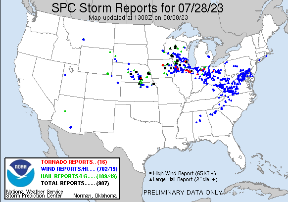
| Tornado Reports (CSV) (Raw Tornado CSV)(?) |
|---|
Time | | Location | County | State | Lat | Lon | Comments |
| 2246 | | 4 ENE Popejoy | Franklin | IA | 4262 | 9336 | Report of weak tornado on the ground with lofted debris visible. (DMX) |
| 2259 | | 4 N Iowa Falls | Franklin | IA | 4258 | 9326 | Tornado continues. (DMX) |
| 0141 | | Andrew | Jackson | IA | 4215 | 9059 | Confirmed tornado by TV6 employee crossed Highway 61 near Andrew. (DVN) |
| 0216 | | 3 E Clinton | Clinton | IA | 4185 | 9018 | A brief tornado developed in Clinton Friday evening ... and crossed the Mississippi River before dissipating near Fulton. The tornado caused sporadic tree damage ... incl (DVN) |
| 0329 | | 2 E Palmyra | Jefferson | WI | 4288 | 8854 | The tornado began near the SW tip of Upper Spring Lake. Numerous trees were topped ... snapped or uprooted along Mill Road. The worst damage was near the intersection of (MKX) |
| 0332 | | 3 S Newark | Kendall | IL | 4149 | 8857 | An NWS Damage Survey confirmed that an EF-0 tornado with peak winds of 85 mph ... a path of 8.8 miles ... and a maximum width of 80 yards impacted Newark to Lisbon. This (LOT) |
| 0351 | | 2 NNW Minooka | Kendall | IL | 4148 | 8828 | An NWS Damage Survey confirmed that an EF-1 tornado with peak winds of 95 mph ... a path length of 7.6 miles ... and a maximum width of 225 yards began on the far north s (LOT) |
| 0354 | | Minooka | Grundy | IL | 4146 | 8827 | An NWS Damage Survey confirmed that an EF-0 tornado with peak winds of 85 mph ... a preliminary path length of at least 5.0 miles ... and a maximum width of 250 yards imp (LOT) |
| 0401 | | 3 SSW Elwood | Will | IL | 4136 | 8813 | An NWS Damage Survey confirmed that an EF-0 tornado with peak winds of 85 mph ... a path of 15.4 miles ... and a maximum width of 60 yards impacted the Midewin Prairie to (LOT) |
| 0419 | | 2 NE Limestone | Kankakee | IL | 4116 | 8795 | An NWS Damage Survey confirmed that an EF-0 tornado with peak winds of 80 mph ... a path length of 6.1 miles ... and a maximum width of 350 yards touched down west of Bou (LOT) |
| 0432 | | 1 WSW Momence | Kankakee | IL | 4116 | 8768 | An NWS Damage Survey confirmed that an EF-1 tornado with peak winds of 110 mph ... a path length of 3.4 miles ... and a maximum width of 90 yards impacted the south side (LOT) |
| 0612 | | 2 ENE Walton | Cass | IN | 4067 | 8621 | A survey of information provided by a resident as well as Cass County Emergency Management revealed a circulation was in contact with the ground at times between Walton (IWX) |
| 0626 | | 2 NNW Lake Everett | Whitley | IN | 4118 | 8532 | GROUND AND STORM SPOTTER ASSISTED DRONE SURVEYS REVEALED A TORNADO TOUCHED DOWN JUST WEST OF THE EEL RIVER GOLF COURSE SOUTH OF CHURUBUSCO AND TRACKED RAPIDLY EAST SOUT (IWX) |
| 0653 | | 3 NNW Hicksville | Defiance | OH | 4133 | 8479 | A ground and drone survey revealed a tornado touched down at a property west of Casebeer Miller Road and north of Buckskin Road ... and tracked quickly to the northeast. (IWX) |
| 0858 | | 3 WNW North Robinson | Crawford | OH | 4080 | 8291 | A tornado touched down near Parcher Road and Route 30 significantly damaging a barn. The tornado traveled east uprooting and snapping numerous trees. Near Lake Galion.. (CLE) |
| 1153 | | 1 NW Sutton | Clay | NE | 4061 | 9787 | Approximate start location of brief tornado that impacted Sutton this morning. EF1 rating with peak wind speeds of 110 MPH. (GID) |
| Hail Reports (CSV) (Raw Hail CSV)(?) |
|---|
Time | Size | Location | County | State | Lat | Lon | Comments |
| 1833 | 100 | 5 ENE Prescott Courthou | Yavapai | AZ | 3456 | 11239 | Quarter sized hail reported in Yavapai Hills area. (FGZ) |
| 1909 | 100 | 4 E Prescott Courthouse | Yavapai | AZ | 3455 | 11240 | Hail around an inch reported near Costco. (FGZ) |
| 1934 | 150 | 2 ENE Sheridan Lake | Pennington | SD | 4398 | 10343 | Large hail dented cars and destroyed a garden. Hail lasted about 10 minutes. (UNR) |
| 2020 | 150 | Cheyenne | Laramie | WY | 4115 | 10479 | Facebook comment with photo of hail stones and quarter. Hail was larger than a quarter. (CYS) |
| 2020 | 100 | 1 W Cheyenne | Laramie | WY | 4115 | 10481 | Report from mPING: Quarter (1.00 in.). (CYS) |
| 2022 | 100 | 1 WNW Cheyenne | Laramie | WY | 4115 | 10481 | Dime to quarter size hail at the NWS Office. (CYS) |
| 2022 | 100 | 1 ESE Warren Af Base | Laramie | WY | 4115 | 10485 | (CYS) |
| 2023 | 150 | 1 WNW Cheyenne | Laramie | WY | 4115 | 10481 | Report from mPING: Ping Pong Ball (1.50 in.). (CYS) |
| 2024 | 100 | 2 NNW South Greeley Hig | Laramie | WY | 4112 | 10482 | (CYS) |
| 2028 | 100 | 1 W Cheyenne | Laramie | WY | 4115 | 10482 | (CYS) |
| 2028 | 100 | 1 NE Cheyenne | Laramie | WY | 4116 | 10478 | (CYS) |
| 2030 | 100 | 2 NW Mossy Creek | White | GA | 3456 | 8371 | 1 inch hail reported on Airport Rd. (FFC) |
| 2031 | 100 | 1 NNW Fox Farm-College | Laramie | WY | 4113 | 10480 | (CYS) |
| 2037 | 100 | 2 NW South Greeley High | Laramie | WY | 4112 | 10483 | (CYS) |
| 2038 | 100 | 1 SE Cheyenne | Laramie | WY | 4113 | 10478 | (CYS) |
| 2041 | 100 | 1 S Cheyenne | Laramie | WY | 4113 | 10479 | (CYS) |
| 2044 | 100 | 1 ESE Warren Af Base | Laramie | WY | 4115 | 10484 | Report from mPING: Quarter (1.00 in.). (CYS) |
| 2056 | 100 | 1 S Iola | Waupaca | WI | 4449 | 8911 | Two public reports of estimated quarter to half dollar sized hail that fell on the south side of Iola. Time estimated based on combination of reports and radar. (GRB) |
| 2108 | 125 | 1 ESE Inwood | Berkeley | WV | 3934 | 7803 | Half dollar size hail was reported in Inwood. (LWX) |
| 2117 | 125 | 4 SW Nora | Nuckolls | NE | 4012 | 9803 | Corrects previous hail report from 4 SW Nora. Half dollar and slightly larger hail reported. 2.25 inches of rainfall and 40 mph with storm. (GID) |
| 2136 | 100 | 4 S Nelson | Nuckolls | NE | 4015 | 9807 | Corrected time of report. EMT reported 1 inch hail near highway 136 intersection south of Nelson. Report received via county dispatch. Time estimated from radar. (GID) |
| 2139 | 100 | 2 NE Nickerson | Dodge | NE | 4155 | 9645 | Report from mPING: Quarter (1.00 in.). (OAX) |
| 2145 | 100 | 3 E Nickerson | Washington | NE | 4153 | 9641 | Dimes to quarter sized hail. (OAX) |
| 2153 | 100 | 1 NNE Sterling Park | Loudoun | VA | 3902 | 7740 | Quarter size hail was reported in Sterling. (LWX) |
| 2153 | 125 | Countryside | Loudoun | VA | 3905 | 7741 | Half dollar size hail was reported in Countryside. (LWX) |
| 2155 | 100 | Sterling Park | Loudoun | VA | 3900 | 7741 | (LWX) |
| 2155 | 200 | Nickerson | Dodge | NE | 4153 | 9647 | (OAX) |
| 2203 | 150 | Republic | Republic | KS | 3992 | 9782 | (TOP) |
| 2209 | 175 | Fremont | Dodge | NE | 4144 | 9649 | Golfball sized hail at Chirstensen Field. (OAX) |
| 2210 | 100 | 2 NE Courtland | Republic | KS | 3980 | 9788 | (TOP) |
| 2211 | 125 | 2 NW Fremont | Dodge | NE | 4145 | 9652 | Report from mPING: Half Dollar (1.25 in.). (OAX) |
| 2215 | 175 | Fremont | Dodge | NE | 4144 | 9649 | Golfbaal hail at 23rd and Broad Streets. (OAX) |
| 2217 | 175 | Fremont | Dodge | NE | 4144 | 9649 | one inch to golfball size hail. (OAX) |
| 2217 | 275 | 3 ENE Fremont | Dodge | NE | 4145 | 9644 | (OAX) |
| 2219 | 275 | 1 SE Fremont | Dodge | NE | 4143 | 9648 | 2.5 to 3 inch hail. (OAX) |
| 2220 | 150 | Fremont | Dodge | NE | 4144 | 9649 | Hail near Near John C. Fremont Park. (OAX) |
| 2222 | 450 | 1 ESE Fremont | Dodge | NE | 4143 | 9647 | Picture of a hailstone compared to a dollar bill. Delayed report. (OAX) |
| 2223 | 300 | 2 E Fremont | Dodge | NE | 4144 | 9645 | Photo sent ... measured with a ruler. Delayed report. (OAX) |
| 2224 | 250 | Fremont | Dodge | NE | 4144 | 9649 | 2 to 2.5 inch hail. (OAX) |
| 2225 | 125 | 1 WSW Fremont | Dodge | NE | 4144 | 9650 | Report from mPING: Half Dollar (1.25 in.). (OAX) |
| 2225 | 100 | New Trier | Dakota | MN | 4461 | 9293 | Social media report relayed via Sogn Valley Skywarn. (MPX) |
| 2227 | 175 | 18 ESE Maudlow | Gallatin | MT | 4597 | 11084 | Several reports of hail from Facebook ... Twitter ... and Gallatin County Sheriff ... ranging from dime size to golf ball size. Reports also mentioned that hail accumulate (TFX) |
| 2229 | 200 | 5 N Valley | Douglas | NE | 4139 | 9635 | (OAX) |
| 2230 | 200 | 1 ENE Giltner | Hamilton | NE | 4079 | 9813 | FB report between egg and tennis ball. (GID) |
| 2233 | 100 | 5 W Washington | Washington | NE | 4140 | 9630 | Report from mPING: Quarter (1.00 in.). (OAX) |
| 2235 | 175 | 18 ESE Maudlow | Gallatin | MT | 4597 | 11084 | Corrects previous hail report from 18 ESE Maudlow. Several reports of hail from Facebook ... Twitter ... and Gallatin County Sheriff ... ranging from dime size to golf bal (TFX) |
| 2235 | 175 | 13 ESE Maudlow | Gallatin | MT | 4604 | 11092 | Follow-up on previously reported thunderstorm damage. Hail sizes ranged from dime size to golf ball size. Reported via Facebook. Time approximated. (TFX) |
| 2236 | 100 | 4 S Nelson | Nuckolls | NE | 4015 | 9807 | EMT reported 1 inch hail near highway 136 intersection south of Nelson. Report received via county dispatch. Time estimated from radar. (GID) |
| 2237 | 200 | Burr Oak | Jewell | KS | 3987 | 9830 | FB Report. (GID) |
| 2237 | 175 | 1 ENE Giltner | Hamilton | NE | 4078 | 9813 | FB Report. time est from radar. (GID) |
| 2237 | 150 | 3 ENE Leshara | Douglas | NE | 4135 | 9639 | Ping pong ball size hail 2 miles north of the NWS Office in Valley. Report from social media. (OAX) |
| 2243 | 100 | 4 NE Giltner | Hamilton | NE | 4083 | 9810 | (GID) |
| 2244 | 175 | 11 NW Wilsall | Park | MT | 4603 | 11079 | (BYZ) |
| 2245 | 100 | 1 NW Aurora | Hamilton | NE | 4087 | 9801 | Nickel to quarter hail. Winds of 15 to 25mph also. (GID) |
| 2245 | 150 | 3 W Washington | Douglas | NE | 4138 | 9627 | Report from mPING: Ping Pong Ball (1.50 in.). (OAX) |
| 2246 | 175 | 16 S Ringling | Gallatin | MT | 4604 | 11080 | NWS Billings received a spotter report along our border west northwest of Wilsall. In addition to hail ... spotter reports estimated 70 mph wind. (TFX) |
| 2250 | 175 | 2 N Elkhorn | Douglas | NE | 4131 | 9623 | (OAX) |
| 2253 | 250 | 2 N Elkhorn | Douglas | NE | 4131 | 9624 | (OAX) |
| 2253 | 250 | 3 NNW Elkhorn | Douglas | NE | 4132 | 9625 | 2 to 2 1/2 inch hail at 213th and Ida. (OAX) |
| 2255 | 200 | 1 N Elkhorn | Douglas | NE | 4129 | 9623 | Hail a bit larger than 2 inches fell at 204th and Maple in Elkhorn ... Report from social media. (OAX) |
| 2255 | 100 | 1 NW Elkhorn | Douglas | NE | 4129 | 9624 | Report from mPING: Quarter (1.00 in.). (OAX) |
| 2255 | 100 | 4 NE Elkhorn | Douglas | NE | 4131 | 9618 | Report from mPING: Quarter (1.00 in.). (OAX) |
| 2255 | 275 | 2 N Elkhorn | Douglas | NE | 4131 | 9623 | Photo sent. Measured with a ruler. Delayed report. (OAX) |
| 2255 | 100 | 3 SW Bennington | Douglas | NE | 4133 | 9617 | Report from mPING: Quarter (1.00 in.). (OAX) |
| 2256 | 100 | 3 NE Elkhorn | Douglas | NE | 4131 | 9620 | Report from mPING: Quarter (1.00 in.). (OAX) |
| 2257 | 200 | 3 E Elkhorn | Douglas | NE | 4128 | 9619 | 2 inch diameter hail at 174th and Blondo in Omaha. Report from Social Media. (OAX) |
| 2259 | 125 | 2 E Elkhorn | Douglas | NE | 4129 | 9620 | Report from mPING: Half Dollar (1.25 in.). (OAX) |
| 2259 | 100 | 4 N Boys Town | Douglas | NE | 4131 | 9615 | Report from mPING: Quarter (1.00 in.). (OAX) |
| 2259 | 125 | 3 SSW Bennington | Douglas | NE | 4133 | 9617 | 1 ito 1.25 inch hail.reported. (OAX) |
| 2259 | 175 | 1 NNE Iowa Falls | Hardin | IA | 4253 | 9326 | Report from social media. (DMX) |
| 2300 | 100 | 5 SSW Scottsville | Mitchell | KS | 3948 | 9799 | Crop damage to corn from hail. Time estimated from radar. (GID) |
| 2300 | 150 | 3 ENE Elkhorn | Douglas | NE | 4129 | 9618 | 1 1/2 inch hail at 168th and Blondo in Omaha. Report from social media. (OAX) |
| 2302 | 100 | 2 S Jamestown | Cloud | KS | 3957 | 9786 | (TOP) |
| 2302 | 175 | 2 E Elkhorn | Douglas | NE | 4129 | 9620 | Report from mPING: Golf Ball (1.75 in.). (OAX) |
| 2303 | 200 | 2 SSW Stockham | Clay | NE | 4069 | 9795 | Hail slightly larger than a golf ball. Estimated 60 MPH wind gusts. Time estimated from radar. (GID) |
| 2305 | 175 | 3 E Stockham | Hamilton | NE | 4071 | 9788 | Report and picture via facebook. (GID) |
| 2305 | 250 | 3 WNW Boys Town | Douglas | NE | 4128 | 9618 | (OAX) |
| 2305 | 125 | 3 NW Readlyn | Bremer | IA | 4274 | 9226 | Delayed report - hail up to half dollar sized. (DMX) |
| 2307 | 150 | 6 SW Geneva | Franklin | IA | 4261 | 9320 | (DMX) |
| 2308 | 200 | 3 ENE Elkhorn | Douglas | NE | 4129 | 9618 | 1.5 to 2.1 inch hail. (OAX) |
| 2308 | 150 | 6 SW Geneva | Franklin | IA | 4260 | 9320 | Report from mPING: Ping Pong Ball (1.50 in.). (DMX) |
| 2308 | 100 | 7 NW Medford | Taylor | WI | 4521 | 9044 | Report from mPING: Quarter (1.00 in.). (ARX) |
| 2309 | 100 | 3 N Boys Town | Douglas | NE | 4130 | 9613 | (OAX) |
| 2310 | 150 | 1 NW Boys Town | Douglas | NE | 4127 | 9615 | Report from mPING: Ping Pong Ball (1.50 in.). (OAX) |
| 2310 | 150 | 2 NNW Boys Town | Douglas | NE | 4128 | 9615 | (OAX) |
| 2311 | 150 | Boys Town | Douglas | NE | 4126 | 9613 | (OAX) |
| 2311 | 175 | 2 N Elkhorn | Douglas | NE | 4131 | 9624 | Report from mPING: Golf Ball (1.75 in.). (OAX) |
| 2311 | 175 | 3 NE Bloomer | Chippewa | WI | 4513 | 9145 | (MPX) |
| 2312 | 100 | 2 SW Boys Town | Douglas | NE | 4124 | 9616 | Report from mPING: Quarter (1.00 in.). (OAX) |
| 2312 | 300 | 3 NE Bloomer | Chippewa | WI | 4513 | 9145 | Spiky hail. Most hail stones were 2 in diameter but the largest was 3 in from spike to spike. (MPX) |
| 2313 | 100 | 1 SE Boys Town | Douglas | NE | 4124 | 9612 | Report from mPING: Quarter (1.00 in.). (OAX) |
| 2313 | 100 | Fennimore | Grant | WI | 4298 | 9066 | Quarter size hail has been falling for 10 minutes. (ARX) |
| 2315 | 250 | 3 NNE Saronville | Clay | NE | 4064 | 9791 | Quarters to tennis ball sized hail. (GID) |
| 2317 | 175 | 3 NW Boys Town | Douglas | NE | 4128 | 9618 | Report from mPING: Golf Ball (1.75 in.). (OAX) |
| 2318 | 100 | 2 SE Cassville | Bartow | GA | 3422 | 8483 | Report from mPING: Quarter (1.00 in.). (FFC) |
| 2318 | 200 | 2 W Saronville | Clay | NE | 4060 | 9798 | FB Report Golf balls with some 2 inch hail mixed in also. (GID) |
| 2318 | 400 | 1 NE Saronville | Clay | NE | 4061 | 9793 | Report via the Media. Time estimated from radar. (GID) |
| 2318 | 225 | 3 NW Boys Town | Douglas | NE | 4128 | 9618 | Report from mPING: Hen Egg+ (2.25 in.). (OAX) |
| 2320 | 300 | Saronville | Clay | NE | 4061 | 9794 | 3.25 inch Hail reported via Facebook with picture of multiple stones along side a tape measure. (GID) |
| 2320 | 100 | 1 NW Boys Town | Douglas | NE | 4127 | 9615 | Report from mPING: Quarter (1.00 in.). (OAX) |
| 2320 | 125 | 3 NW Readlyn | Bremer | IA | 4274 | 9226 | Report from mPING of Half Dollar (1.25 in.). (DMX) |
| 2323 | 100 | 2 W Ralston | Douglas | NE | 4120 | 9608 | Report from mPING: Quarter (1.00 in.). (OAX) |
| 2323 | 275 | 3 N Denver | Bremer | IA | 4272 | 9234 | (DMX) |
| 2324 | 175 | Medford | Taylor | WI | 4514 | 9035 | Golfball size hail at the fairgrounds. (ARX) |
| 2325 | 250 | 1 SW Sutton | Clay | NE | 4060 | 9788 | Report and picture via Facebook. (GID) |
| 2325 | 250 | 1 W Medford | Taylor | WI | 4514 | 9037 | (ARX) |
| 2325 | 200 | 1 NE Medford | Taylor | WI | 4515 | 9033 | (ARX) |
| 2329 | 200 | 5 S Saronville | Clay | NE | 4053 | 9792 | Some golf balls with a few larger stones mixed in. (GID) |
| 2333 | 175 | Holmen | La Crosse | WI | 4396 | 9126 | (ARX) |
| 2333 | 275 | 3 E Holmen | La Crosse | WI | 4396 | 9120 | (ARX) |
| 2341 | 200 | 4 SSW Ogema | Price | WI | 4539 | 9033 | Corrects location and time of earlier report from 4 SSE Ogema received Saturday. Location provided by spotter. Time estimated from radar. A photo was received via a TV (DLH) |
| 2342 | 100 | 6 SSW Asherville | Mitchell | KS | 3933 | 9803 | Widespread crop damage to corn ... soy and Milo. Full grown Milo cut down to 3 inches. 3 Mile wide swath near 350/Q Roads. Severe winds also likely contributed. Time est (GID) |
| 2345 | 300 | 1 NW West Salem | La Crosse | WI | 4391 | 9109 | Verified by picture. (ARX) |
| 2348 | 100 | 3 W Holland | Grundy | IA | 4240 | 9286 | Accompanied with estimated 60 mph wind gust from Wellsburg to Grundy Center area. (DMX) |
| 2352 | 275 | Bangor | La Crosse | WI | 4389 | 9099 | (ARX) |
| 2355 | 200 | 4 SSE Ogema | Price | WI | 4540 | 9026 | Corrects location of previous hail report from Ogema. A photo was received via a TV partner of a hailstone and a tape measure. The largest axis of the hail was 2 inches (DLH) |
| 2355 | 200 | Ogema | Price | WI | 4544 | 9030 | A photo was received via a TV partner of a hailstone and a tape measure. The largest axis of the hail was 2 inches in diameter. (DLH) |
| 0000 | 175 | 3 S Shickley | Fillmore | NE | 4037 | 9773 | Observer reported golf ball sized hail with small stones mixed in. (GID) |
| 0003 | 100 | 1 N Lincoln | Lancaster | NE | 4083 | 9669 | (OAX) |
| 0007 | 100 | 1 W Lincoln | Lancaster | NE | 4082 | 9671 | (OAX) |
| 0009 | 175 | 5 SSW Lincoln | Lancaster | NE | 4075 | 9672 | Golf Ball hail at US 77 and Warlick Blvd in Lincoln. (OAX) |
| 0010 | 150 | 5 SW Lincoln | Lancaster | NE | 4077 | 9676 | (OAX) |
| 0012 | 200 | Platteville | Grant | WI | 4274 | 9048 | Golf ball to hen egg size hail in Platteville. (ARX) |
| 0016 | 175 | 5 S Lincoln | Lancaster | NE | 4074 | 9667 | Corrects previous hail report from 5 S Lincoln. Golf Ball Hail at 32nd St and Pine Lake Road. (OAX) |
| 0017 | 100 | 5 S Lincoln | Lancaster | NE | 4075 | 9670 | Report from mPING: Quarter (1.00 in.). (OAX) |
| 0019 | 300 | Galesville | Trempealeau | WI | 4408 | 9136 | Measured and confirmed with photo. (ARX) |
| 0021 | 175 | Galesville | Trempealeau | WI | 4408 | 9136 | (ARX) |
| 0023 | 125 | 5 N Roca | Lancaster | NE | 4072 | 9668 | Report from mPING: Half Dollar (1.25 in.). (OAX) |
| 0025 | 250 | 3 W Belmont | Lafayette | WI | 4273 | 9039 | Picture via Twitter. (MKX) |
| 0025 | 100 | 2 WSW Rib Falls | Marathon | WI | 4495 | 8993 | Report from mPING: Quarter (1.00 in.). (GRB) |
| 0027 | 200 | Belmont | Lafayette | WI | 4274 | 9033 | via MPING. (MKX) |
| 0030 | 125 | 1 E Warrenville | DuPage | IL | 4182 | 8816 | Report from mPING: Half Dollar (1.25 in.). (LOT) |
| 0030 | 175 | 4 NE New Amsterdam | La Crosse | WI | 4403 | 9127 | (ARX) |
| 0030 | 200 | 4 NW Stevenstown | Trempealeau | WI | 4407 | 9123 | (ARX) |
| 0033 | 175 | Holmen | La Crosse | WI | 4396 | 9126 | Corrects previous hail report from Holmen. (ARX) |
| 0033 | 275 | 3 E Holmen | La Crosse | WI | 4396 | 9120 | Corrects previous hail report from 3 E Holmen. (ARX) |
| 0035 | 100 | 1 SSW Marathon City | Marathon | WI | 4494 | 8984 | Public report from social media of estimated quarter sized hail. (GRB) |
| 0039 | 100 | 1 S Edmore | Dubuque | IA | 4253 | 9068 | Reported at Dubuque County Fairgrounds. (DVN) |
| 0043 | 150 | 1 SSW Winfield | DuPage | IL | 4186 | 8816 | Minor leaf damage and car dents. (LOT) |
| 0045 | 100 | Darlington | Lafayette | WI | 4268 | 9012 | (MKX) |
| 0045 | 300 | 1 NW West Salem | La Crosse | WI | 4391 | 9109 | Corrects previous hail report from 1 NW West Salem. Verified by picture. (ARX) |
| 0045 | 100 | 4 E Holmen | La Crosse | WI | 4398 | 9119 | (ARX) |
| 0046 | 250 | 1 W West Salem | La Crosse | WI | 4390 | 9109 | (ARX) |
| 0046 | 250 | 1 WSW West Salem | La Crosse | WI | 4390 | 9110 | Some roof damage. (ARX) |
| 0046 | 250 | 1 NNE West Salem | La Crosse | WI | 4391 | 9107 | Tennis ball hail broke windows. (ARX) |
| 0047 | 100 | West Chicago | DuPage | IL | 4189 | 8819 | Quarter size hail near IL-59 and Washington in West Chicago. (LOT) |
| 0050 | 175 | Winfield | DuPage | IL | 4187 | 8816 | Just west of central DuPage hospital. (LOT) |
| 0050 | 150 | 1 NE Barre Mills | La Crosse | WI | 4384 | 9111 | Report from mPING: Ping Pong Ball (1.50 in.). (ARX) |
| 0050 | 275 | 2 NE West Salem | La Crosse | WI | 4391 | 9105 | Law enforcement reports baseball size hail on Neshonoc Rd. (ARX) |
| 0051 | 150 | 3 SSE Mountain | Oconto | WI | 4515 | 8845 | Public report of around ping pong ball to possibly golf ball sized hail. Time estimated based on report and radar. (GRB) |
| 0052 | 275 | Bangor | La Crosse | WI | 4389 | 9099 | Corrects previous hail report from Bangor. (ARX) |
| 0052 | 400 | 2 E West Salem | La Crosse | WI | 4390 | 9104 | Social media photo with rulers for reference. (ARX) |
| 0055 | 100 | 1 ENE Wheaton | DuPage | IL | 4187 | 8809 | In Wheaton near College Ave Metra. (LOT) |
| 0055 | 150 | Bangor | La Crosse | WI | 4389 | 9099 | (ARX) |
| 0100 | 125 | 1 W Carol Stream | DuPage | IL | 4191 | 8816 | Picture from Twitter. (LOT) |
| 0102 | 100 | 1 SW Glen Ellyn | DuPage | IL | 4187 | 8808 | Report from mPING: Quarter (1.00 in.). (LOT) |
| 0104 | 100 | 3 NNE Tucson | Pima | AZ | 3224 | 11086 | Report from mPING: Quarter (1.00 in.). (TWC) |
| 0104 | 100 | 2 WNW Marshalltown | Marshall | IA | 4205 | 9295 | Delayed Report from mPING: Quarter (1.00 in.). (DMX) |
| 0105 | 125 | 1 W Carol Stream | DuPage | IL | 4191 | 8816 | Just west of Carol Stream. (LOT) |
| 0110 | 100 | 4 N Tucson | Pima | AZ | 3225 | 11089 | (TWC) |
| 0110 | 100 | 1 SE Mount Carmel | Hawkins | TN | 3655 | 8264 | Hail lasted for almost 10 minutes. (MRX) |
| 0111 | 150 | 5 N Tucson | Pima | AZ | 3227 | 11088 | (TWC) |
| 0114 | 100 | 1 S Toledo | Tama | IA | 4198 | 9258 | (DMX) |
| 0115 | 100 | 5 NW Tucson | Pima | AZ | 3225 | 11094 | (TWC) |
| 0117 | 125 | Mukwonago | Waukesha | WI | 4287 | 8833 | Half dollar sized hail relayed from broadcast media. (MKX) |
| 0120 | 100 | 5 NW Tucson | Pima | AZ | 3225 | 11094 | (TWC) |
| 0125 | 100 | 4 NW Tucson | Pima | AZ | 3224 | 11094 | (TWC) |
| 0130 | 150 | 4 NNE Tucson | Pima | AZ | 3225 | 11088 | (TWC) |
| 0130 | 100 | 4 NNW Tucson | Pima | AZ | 3225 | 11091 | (TWC) |
| 0135 | 100 | 3 N Tucson | Pima | AZ | 3224 | 11090 | (TWC) |
| 0136 | 250 | Waterford | Racine | WI | 4276 | 8822 | Picture via Facebook. (MKX) |
| 0140 | 100 | Waterford | Racine | WI | 4276 | 8822 | Report relayed from social media. (MKX) |
| 0140 | 250 | 1 SSW Waterford North | Racine | WI | 4278 | 8823 | Reports from MPING and through Twitter. (MKX) |
| 0216 | 100 | 1 E Sextonville | Richland | WI | 4328 | 9028 | (ARX) |
| 0220 | 175 | 2 ESE Sextonville | Richland | WI | 4327 | 9025 | (ARX) |
| 0235 | 100 | 1 NE Kimmel | Noble | IN | 4141 | 8553 | Some melting has occurred in the picture provided so the size could have been approaching 1.25 inch diam hail. Time estimated by radar. (IWX) |
| 0244 | 100 | 4 S Netawaka | Jackson | KS | 3955 | 9572 | (TOP) |
| 0330 | 100 | 1 S Sycamore | De Kalb | IL | 4197 | 8868 | (LOT) |
| 0333 | 100 | 1 S Sycamore | De Kalb | IL | 4197 | 8868 | Relayed via spotter network. (LOT) |
| 0340 | 175 | 4 NW Eddyville | Mahaska | IA | 4119 | 9270 | Golf ball sized hail. (DMX) |
| 0424 | 100 | 2 N Attica | Marion | IA | 4126 | 9301 | Largest stones were quarter sized. (DMX) |
| 0427 | 100 | Montpelier | Blackford | IN | 4055 | 8528 | Photos on Facebook of quarter size hail in Pioneer. (IWX) |
| 0427 | 125 | Montpelier | Williams | OH | 4158 | 8460 | Photo on Facebook of hail slightly larger than a quarter. (IWX) |
| 0430 | 125 | 1 E Montpelier | Blackford | IN | 4055 | 8526 | Photo on Facebook on hail slightly larger than a quarter. (IWX) |
| 0433 | 100 | Pioneer | Williams | OH | 4168 | 8455 | Photos on Facebook show several quarter size hailstones in Pioneer. (IWX) |
| 0600 | 100 | 6 S Devils Tower | Crook | WY | 4450 | 10469 | (UNR) |
| 0640 | 100 | Oelrichs | Fall River | SD | 4318 | 10323 | (UNR) |
| 0831 | 100 | 5 W Stapleton | Logan | NE | 4148 | 10061 | (LBF) |
| 0855 | 100 | 3 N Taylor | Loup | NE | 4181 | 9938 | (LBF) |
| Wind Reports (CSV) (Raw Wind CSV)(?) |
|---|
Time | Speed | Location | County | State | Lat | Lon | Comments |
| 1255 | 71 | 5 N Pawnee Buttes | Weld | CO | 4088 | 10400 | AWOS station K1OW 2 NW Pawnee Buttes. (BOU) |
| 1336 | UNK | Stevensville | Queen Anne's | MD | 3899 | 7631 | Tree down in Stevensville per 911 call center. Time estimated from radar. (PHI) |
| 1414 | UNK | 3 WSW Riverdale | Scott | IA | 4152 | 9052 | several 2 inch diameter tree limbs down. Time estimated using radar. (DVN) |
| 1516 | UNK | Fort Atkinson | Jefferson | WI | 4293 | 8884 | Report relayed via broadcast media. Multiple tree limbs around 10 inches in diameter down on vehicle. Estimated wind gusts around 60 mph. Time estimated based on radar. (MKX) |
| 1543 | UNK | 2 NNE Delaware Coastal | Sussex | DE | 3872 | 7534 | Power lines down per 911 call center. Time estimated from radar. (PHI) |
| 1627 | UNK | 3 SSW MOUNT STERLING | FAYETTE | OH | 3969 | 8329 | TREES WERE BLOWN DOWN IN THE MOUNT STERLING AREA. TIME ESTIMATED FROM RADAR. (ILN) |
| 1703 | UNK | Chillicothe | Ross | OH | 3934 | 8298 | Several trees ... large limbs of 6-12 inch in diameter ... downed in Chillicothe. Time estimated by radar. (ILN) |
| 1705 | UNK | 2 S Sudith | Menifee | KY | 3799 | 8363 | Tree reported down at the intersection of Highway 36 and Stone Quarry Road. Time estimated by radar. (JKL) |
| 1723 | UNK | Smithville | Wayne | OH | 4086 | 8186 | Trees and wires down in Smithville. Time estimated via radar. (CLE) |
| 1725 | UNK | Vanceburg | Lewis | KY | 3860 | 8332 | trees down on KY-8. (ILN) |
| 1750 | UNK | Shawnee | Perry | OH | 3961 | 8221 | Trees down on State Route 37 and across southern end of county causing power outages. (RLX) |
| 1800 | UNK | 3 NW Greenup | Greenup | KY | 3860 | 8288 | Mckay Rd/Smith Branch Rd. Tree down on power lines. (RLX) |
| 1804 | 59 | 2 WNW Cannonsburg | Boyd | KY | 3840 | 8274 | Boyd County EOC. (RLX) |
| 1805 | UNK | Flatwoods | Greenup | KY | 3851 | 8271 | Tree blocking roadway. (RLX) |
| 1806 | UNK | Greenup | Greenup | KY | 3857 | 8283 | 2nd and CSX Railroad. Small tree down across railroad tracks. (RLX) |
| 1809 | UNK | Canton Twp | Stark | OH | 4075 | 8137 | Tree downed in Canton Township. (CLE) |
| 1813 | UNK | Ross Bridge | Jefferson | AL | 3339 | 8687 | Large branches broken with at least one tree blown down ... as well as accompanying power outages in the Bluff Park/Ross Bridge area. (BMX) |
| 1815 | 59 | 2 WNW Cannonsburg | Boyd | KY | 3840 | 8274 | Corrects previous non-tstm wnd gst report from 2 WNW Cannonsburg. Mesonet station GW3636 ASHLAND. (RLX) |
| 1816 | 59 | 2 WNW Cannonsburg | Boyd | KY | 3840 | 8274 | (RLX) |
| 1835 | UNK | Coolville | Athens | OH | 3923 | 8179 | Trees down. (RLX) |
| 1840 | UNK | Bellefonte | Greenup | KY | 3849 | 8269 | Trees and power lines down ... the power is out. (RLX) |
| 1841 | UNK | 1 E Chesapeake | Lawrence | OH | 3843 | 8244 | Tree down. (RLX) |
| 1842 | UNK | 6 NNW Harts | Lincoln | WV | 3810 | 8218 | Corrects time of previous tstm wnd dmg report from 6 NNW Harts. Trees and lines down. (RLX) |
| 1845 | UNK | 5 W Belpre | Washington | OH | 3928 | 8168 | Multiple trees down centered around Little Hocking. (RLX) |
| 1850 | UNK | 1 W Parkersburg | Wood | WV | 3926 | 8156 | Trees down. (RLX) |
| 1851 | UNK | 1 W Campton | Wolfe | KY | 3774 | 8356 | Report on social media of tree reported down at residence. Time estimated from radar. (JKL) |
| 1855 | UNK | 1 ESE Parkersburg | Wood | WV | 3926 | 8152 | Multiple trees and power lines down from Williamstown down to Parkersburg. (RLX) |
| 1900 | UNK | West Hamlin | Lincoln | WV | 3828 | 8220 | Trees and lines down. (RLX) |
| 1901 | UNK | 7 SSE Hurricane | Putnam | WV | 3834 | 8198 | Corrects time of previous tstm wnd dmg report from 7 SSE Hurricane. Power lines are down and in the trees. (RLX) |
| 1904 | UNK | 2 WSW Adamsville | Jefferson | AL | 3360 | 8699 | Power lines down in Adamsville. (BMX) |
| 1905 | UNK | 4 SSW Belmont | Pleasants | WV | 3933 | 8129 | Multiple trees down including Horseneck Road. (RLX) |
| 1909 | UNK | 2 NW Eleanor | Putnam | WV | 3856 | 8196 | Charleston Rd/Midway Hollow Rd. Tree down across both lanes of traffic. (RLX) |
| 1911 | UNK | 3 W Danville | Boone | WV | 3808 | 8189 | Tree down. (RLX) |
| 1913 | UNK | 7 SSW Madison | Boone | WV | 3796 | 8185 | Tree down. (RLX) |
| 1913 | UNK | 1 N Teays Valley | Putnam | WV | 3846 | 8193 | Tree down. (RLX) |
| 1915 | UNK | 7 SSW Madison | Boone | WV | 3796 | 8185 | Tree down. (RLX) |
| 1915 | UNK | 3 N Teays Valley | Putnam | WV | 3849 | 8193 | Received a report from the public of several trees down along Route 34 N between Teays Valley and Winfield. Time estimated from radar. (RLX) |
| 1916 | UNK | 1 E Teays Valley | Putnam | WV | 3845 | 8191 | Tree down at Scott Teays Elementary School. (RLX) |
| 1920 | UNK | 1 E Saint Albans | Kanawha | WV | 3838 | 8180 | Metro 911 report of trees down at Chestnut Street and Wilson Avenue in Saint Albans. (RLX) |
| 1920 | UNK | 1 SE Nitro | Kanawha | WV | 3841 | 8182 | Metro 911 reports tree down on Blake Rd in Nitro. (RLX) |
| 1920 | UNK | 2 WNW Teays Valley | Putnam | WV | 3846 | 8197 | One tree across the roadway. (RLX) |
| 1920 | UNK | 6 SE Saint Marys | Pleasants | WV | 3933 | 8114 | Large tree down across the front porch of a residence. (RLX) |
| 1924 | UNK | 4 SE Madison | Boone | WV | 3801 | 8176 | The emergency manager in Boone County sent two pictures of part of a roof and walls blown off of a trailer around the 40 block of Peaceful Dr in Madison. Time estimate (RLX) |
| 1925 | UNK | 1 W Madison | Boone | WV | 3806 | 8182 | Tree down ... blocking roadway. (RLX) |
| 1925 | UNK | 2 SSW South Charleston | Kanawha | WV | 3833 | 8171 | Metro 911 report of trees down at in the Trace Fork Shopping Center. (RLX) |
| 1925 | UNK | 1 ENE South Charleston | Kanawha | WV | 3836 | 8169 | Metro 911 report of trees down at Phillips Street and Valley Drive. (RLX) |
| 1925 | UNK | Ellenboro | Ritchie | WV | 3926 | 8105 | Several trees down with the most concentrated area between Harrisville and Pleasants County line. (RLX) |
| 1927 | UNK | 1 WSW Madison | Boone | WV | 3806 | 8181 | Wires down. (RLX) |
| 1927 | UNK | Hurricane | Putnam | WV | 3843 | 8202 | Tree down. (RLX) |
| 1927 | UNK | 3 NE Hurricane | Putnam | WV | 3846 | 8198 | Tree down. (RLX) |
| 1930 | UNK | 8 SE Madison | Boone | WV | 3797 | 8171 | Tree down. (RLX) |
| 1930 | UNK | 1 E Danville | Boone | WV | 3808 | 8182 | Approx. 7 trees down ... blocking roadway. (RLX) |
| 1930 | UNK | 1 WNW Danville | Boone | WV | 3809 | 8186 | Wires down. (RLX) |
| 1930 | UNK | 2 WSW Charleston | Kanawha | WV | 3834 | 8166 | Metro 911 relays multiple reports of trees down in the South Hills area of Charleston. (RLX) |
| 1930 | UNK | Charleston | Kanawha | WV | 3835 | 8164 | Metro 911 relays reports of trees down in the downtown area of Charleston. (RLX) |
| 1932 | UNK | 3 W Coal Fork | Kanawha | WV | 3832 | 8157 | Metro 911 relays multiple reports of trees down in Kanawha City area of Charleston. (RLX) |
| 1932 | UNK | 2 NNW Hurricane | Putnam | WV | 3847 | 8203 | Tree down. (RLX) |
| 1935 | UNK | 5 SSE Auburn | Gilmer | WV | 3903 | 8082 | The joint 911 center for Gilmer and Lewis counties reported a tree down in the 7600 block of Alice Road near the town of Coxs Mills. Time estimated via radar. (RLX) |
| 1936 | UNK | 6 E Chapmanville | Boone | WV | 3799 | 8192 | Tree down. (RLX) |
| 1936 | UNK | 1 SE Sylvester | Boone | WV | 3800 | 8154 | Tree down. (RLX) |
| 1938 | UNK | 2 W Pinch | Kanawha | WV | 3840 | 8152 | Metro 911 reports tree down on Indian Creek Road in Bream. (RLX) |
| 1939 | UNK | 2 W Poca | Putnam | WV | 3847 | 8186 | Tree down. (RLX) |
| 1941 | 62 | 3 NE Charleston | Kanawha | WV | 3838 | 8158 | Corrects previous non-tstm wnd gst report from 3 NE Charleston. ASOS station KCRW Charleston Airport. (RLX) |
| 1945 | UNK | 1 NNW West Union | Doddridge | WV | 3931 | 8078 | Multiple trees down mainly north of West Union. (RLX) |
| 1950 | UNK | 2 NE Sand Fork | Gilmer | WV | 3894 | 8072 | Tree down in the roadway. (RLX) |
| 1954 | UNK | 4 S Sand Fork | Gilmer | WV | 3886 | 8075 | Multiple trees and lines down in the area of Toler Run Rd & Dusk Camp Run Rd in Sand Fork. Lightning also struck a power pole and damaged a transformer. This report cam (RLX) |
| 1958 | UNK | 2 ENE Danville | Boone | WV | 3809 | 8181 | Wires down. (RLX) |
| 2000 | UNK | 3 SSW Gamewell | Burke | NC | 3582 | 8162 | Trees and powerlines down on Antioch Rd. Time estimated. (GSP) |
| 2000 | UNK | Clay | Clay | WV | 3846 | 8107 | Trees reported down county wide. (RLX) |
| 2004 | UNK | 1 SSW Beckley | Raleigh | WV | 3778 | 8119 | Raleigh County 911 Center reported there are live power lines down in the 3100 Block of Robert C Byrd Drive near Piney Avenue. Time estimated from Radar. (RLX) |
| 2005 | UNK | 1 ENE Crab Orchard | Raleigh | WV | 3775 | 8122 | Corrects time of previous tstm wnd dmg report from 1 ENE Crab Orchard. TREE ON THE LINES AND ITS SMOKING. (RLX) |
| 2007 | UNK | 1 SSW Beckley | Raleigh | WV | 3778 | 8119 | POWER LINE DOWN LIVE IN THE ROADWAY. (RLX) |
| 2008 | UNK | Sophia | Raleigh | WV | 3771 | 8125 | Raleigh County 911 Center reports power pole blown over in the 100 block of Walker Street in the town of Sophia. Time estimated via radar. (RLX) |
| 2009 | UNK | 1 SW Kimball | McDowell | WV | 3742 | 8152 | Report came in from McDowell County 911 Center of a tree blocking one lane in the 26400 block of Coal Heritage Road near Kimball. Time estimated via radar. (RLX) |
| 2010 | UNK | Sophia | Raleigh | WV | 3771 | 8125 | TREE DOWN ON THE POWER LINE. NOT IN THE ROADWAY ... ITS IN THE ALLEY. NO POWER. (RLX) |
| 2010 | UNK | 3 SW Lester | Raleigh | WV | 3771 | 8134 | Power pole and lines down in the 100 block of Dewey Road in the town of Slab Fork. Report received via Raleigh County 911. Time estimated from radar. (RLX) |
| 2012 | UNK | 1 S Jane Lew | Lewis | WV | 3909 | 8041 | The joint 911 center for Gilmer and Lewis counties sent us a report near Jane Lew ... WV. There is a tree down blocking one lane of travel on US Highway 19 N at the inte (RLX) |
| 2015 | UNK | Keystone | McDowell | WV | 3742 | 8144 | Corrects time of previous tstm wnd dmg report from Keystone. Tree down near Northfork Fire Department. Blocking 1 lane and part of another. Going toward town past FD. N (RLX) |
| 2015 | UNK | 1 SSW Coal City | Raleigh | WV | 3766 | 8122 | Corrects time of previous tstm wnd dmg report from 1 SSW Coal City. JUST BEFORE EPPERLY RD. ADV TREE DOWN IN LIVE POWER LINES. NO FLAMES OR SPARKS SEEN. POWER IS OUT. T (RLX) |
| 2016 | UNK | 3 N Rhodell | Raleigh | WV | 3765 | 8132 | TREE DOWN AND THE TREE IS SMOKING. LINES INVOLVED. (RLX) |
| 2018 | UNK | Northfork | McDowell | WV | 3742 | 8142 | McDowell County 911 Center reported a tree down in the curve around the 800 Block of Cherokee Road in the town of Northfork. Time estimated from radar. (RLX) |
| 2020 | UNK | 3 SSW Honaker | Russell | VA | 3697 | 8199 | Widespread trees down county-wide. (MRX) |
| 2020 | UNK | Rocky Mount | Franklin | VA | 3700 | 7988 | Two trees down in Rocky Mount. One was on a power line. (RNK) |
| 2020 | UNK | 1 S Anawalt | McDowell | WV | 3732 | 8144 | Corrects time of previous tstm wnd dmg report from 1 S Anawalt. Two trees down ... power lines down too. (RLX) |
| 2020 | UNK | 2 SSW Karo | Warren | VA | 3884 | 7826 | There were several reports of trees and wires blown down in southern Warren County ... including in Browntown and Bentonville ... and along VA-607 Rocky Lane. (LWX) |
| 2020 | UNK | 3 NE Rock Cave | Upshur | WV | 3886 | 8029 | County 911 reports tree down ... approx 18 inches in diameter ... along Bush Run Rd in French Creek. (RLX) |
| 2020 | UNK | Clarksburg | Harrison | WV | 3928 | 8033 | Multiple trees down in Clarksburg including Davisson Run Road ... Tiffany Terrace ... Arthur Avenue ... and Crooked Run Road. (RLX) |
| 2025 | UNK | 2 WNW Leaf | White | GA | 3458 | 8369 | Tree down on 115 E in White County. (FFC) |
| 2026 | UNK | 1 WSW Boyce | Clarke | VA | 3909 | 7807 | *** 1 INJ *** Several dozen trees and wires blew down in the Boyce area of Clarke County ... including several onto vehicles. One tree blew down onto a car in the 11800 (LWX) |
| 2030 | UNK | 3 WNW Mossy Creek | White | GA | 3456 | 8373 | Multiple trees reported down at Post Rd and Stover Rd. (FFC) |
| 2030 | UNK | 1 NE Coaldale | Mercer | WV | 3736 | 8133 | Tree and powerlines down on Route 52 in Coaldale. (RNK) |
| 2035 | UNK | 1 S Valdese | Burke | NC | 3573 | 8156 | Corrects previous tstm wnd dmg report from 1 S Valdese. Trees blocking Interstate 40 at mile marker 110. Time estimated. (GSP) |
| 2035 | UNK | Bramwell | Mercer | WV | 3733 | 8131 | Numerous trees and power poles down in Bramwell. (RNK) |
| 2040 | UNK | 4 S Fairview | Cullman | AL | 3419 | 8669 | Tree down off of CR1648. (HUN) |
| 2040 | UNK | 1 SSE Glenray | Monroe | WV | 3770 | 8066 | Numerous trees and power poles down ... including 300 year old oaks. A transformer was knocked down. (RNK) |
| 2040 | UNK | 4 N Webster Springs | Webster | WV | 3854 | 8042 | Large oak tree blocking School House Hollow Rd. (RLX) |
| 2042 | UNK | 2 NE Flatwoods | Tuscaloosa | AL | 3327 | 8760 | Scattered ... relatively minor wind damage around the City of Tuscaloosa ... as well as Northport and Coaling. Some trees were blown down along with a few large branches (BMX) |
| 2044 | UNK | 2 ESE Red Sulphur Sprin | Monroe | WV | 3749 | 8074 | Large tree down across Pine Grove Road. (RNK) |
| 2044 | UNK | 4 NW Webster Springs | Webster | WV | 3851 | 8046 | 911 center reports tree down across Leatherwood Run Road ... blocking all access up the valley. (RLX) |
| 2045 | UNK | 6 NNE Hanceville | Cullman | AL | 3414 | 8672 | Trees reported down along County Road 643. An awning was also blown off of a mobile home. Time estimated. (HUN) |
| 2045 | UNK | 1 SSE Glenray | Monroe | WV | 3770 | 8066 | At least 10 trees down along with damage to barn and crops. (RNK) |
| 2045 | UNK | 2 SE Bingham | Greenbrier | WV | 3802 | 8078 | Tree down on Bingham Road. (RNK) |
| 2047 | UNK | 3 NNW Briggs | Clarke | VA | 3915 | 7805 | Several trees and wires blew down north of Briggs ... including near the intersection of VA-657 Senseny Road and VA-632 Triple J Road. (LWX) |
| 2048 | UNK | 2 NE Clermont | Hall | GA | 3450 | 8375 | Tree down on Hub Head Rd. (FFC) |
| 2048 | UNK | Narrows | Giles | VA | 3733 | 8081 | Trees reported down in Narrows. (RNK) |
| 2050 | UNK | 5 ENE Webster Springs | Webster | WV | 3852 | 8034 | Tree down on Point Mountain Road ... state route 15 ... east of Webster Springs. (RLX) |
| 2052 | UNK | 2 NW Philippi | Barbour | WV | 3918 | 8007 | County 911 reports a tree down across Hackers Creek Road and on the power lines. (RLX) |
| 2053 | UNK | 3 ENE Chapel | Giles | VA | 3730 | 8088 | Tree down on Old Wolf Creek Road. (RNK) |
| 2057 | UNK | Newville | Cumberland | PA | 4017 | 7740 | Trees/wires down. (CTP) |
| 2100 | UNK | 5 NNE Hanceville | Cullman | AL | 3414 | 8674 | Trees and powerlines downed at CR747 and CR703. (HUN) |
| 2102 | UNK | Flint Hill | Rappahannock | VA | 3876 | 7810 | Trees and wires blew down along US-522 Zachary Taylor Highway near Ben Venue Road. (LWX) |
| 2104 | UNK | Flint Hill | Rappahannock | VA | 3876 | 7810 | Multiple trees down in Flint Hill on Zachary Taylor HIghway and Fodderstack Road. (LWX) |
| 2106 | UNK | 3 E War Hill Park | Hall | GA | 3433 | 8392 | Tree down on Deepwater Drive. (FFC) |
| 2106 | UNK | Ronceverte | Greenbrier | WV | 3775 | 8047 | Multiple trees downed by thunderstorm winds in Ronceverte. (RNK) |
| 2110 | UNK | Callands | Pittsylvania | VA | 3682 | 7958 | Two trees down in Callands. (RNK) |
| 2110 | UNK | 2 NNW Newport | Giles | VA | 3731 | 8052 | Tree down on Maybrook Road. (RNK) |
| 2112 | UNK | 1 SSW Castlewood | Russell | VA | 3687 | 8229 | Reports of trees down. (MRX) |
| 2114 | UNK | 5 NE Cullman | Cullman | AL | 3422 | 8677 | Tree down in the 1800 block of CR1545. (HUN) |
| 2115 | UNK | 2 NW Middleway | Berkeley | WV | 3933 | 7801 | Numerous trees blew down in southwestern Jefferson County. (LWX) |
| 2117 | UNK | 4 E Fayetteville | Franklin | PA | 3991 | 7749 | Numerous trees down on wires east of Fayetteville. (CTP) |
| 2118 | UNK | Berea | Greenville | SC | 3488 | 8247 | County Sheriffs Dispatch received numerous reports of trees down north and west of Greenville. Time estimated from radar. (GSP) |
| 2122 | UNK | 2 NE Inwood | Berkeley | WV | 3937 | 7802 | Large tree limbs down blocking road near intersection of Hatchery Road and Winchester Avenue. (LWX) |
| 2124 | UNK | 3 NNW Earlehurst | Alleghany | VA | 3770 | 8028 | Tree down at the intersection of Big Ridge Road and Longtail Road. (RNK) |
| 2125 | UNK | 1 SSW Castlewood | Russell | VA | 3687 | 8229 | Corrects previous tstm wnd dmg report from 1 SSW Castlewood. Reports of trees down. (MRX) |
| 2125 | UNK | 1 SSE Blacksburg | Montgomery | VA | 3722 | 8041 | Large maple tree blown down. (RNK) |
| 2125 | UNK | Inwood | Berkeley | WV | 3936 | 7805 | Tree damage was reported in Inwood ... including in the 1900 block of CR-51/5 Henshaw Road. (LWX) |
| 2127 | UNK | Blacksburg | Montgomery | VA | 3723 | 8042 | Multiple limbs down across the Virginia Tech campus. (RNK) |
| 2127 | UNK | 2 SSW Alvon | Greenbrier | WV | 3788 | 8023 | Tree down along Pocahontas Trail. (RNK) |
| 2128 | UNK | 3 NNE Lumpkin | Dawson | GA | 3440 | 8401 | Couple of trees down on Hwy 136 west of hwy 400. (FFC) |
| 2128 | UNK | 3 NW Harmony | Iredell | NC | 3599 | 8080 | A tree and power line down on West Memorial Hwy. (GSP) |
| 2129 | UNK | 1 ESE Earlehurst | Alleghany | VA | 3766 | 8024 | Tree uprooted on Long Bridge Hollow. (RNK) |
| 2130 | UNK | 1 SW Mountain Valley | Henry | VA | 3677 | 7972 | Tree down at the intersection of Pruitt Mountain Lane and Carter Hill Lane. (RNK) |
| 2130 | UNK | 1 S Blacksburg | Montgomery | VA | 3721 | 8041 | Tree down in the NWS parking lot. (RNK) |
| 2130 | UNK | 1 SW Blacksburg | Montgomery | VA | 3722 | 8043 | One live tree snapped and one large limb down. (RNK) |
| 2130 | UNK | 1 W Blacksburg | Montgomery | VA | 3723 | 8043 | Tree fell on a car at Woodland Drive and Prices Fork Road. (RNK) |
| 2132 | UNK | 2 WSW Moler Crossroads | Jefferson | WV | 3938 | 7780 | Trees blew down along WV-230 Shepherdstown Pike in the 5300 block. (LWX) |
| 2135 | UNK | 4 ESE Pickens | Pickens | SC | 3487 | 8264 | A few trees reported down between Pickens and Easley. Time estimated from radar. (GSP) |
| 2135 | UNK | 1 NE Childress | Montgomery | VA | 3708 | 8051 | Trees blown down. (RNK) |
| 2135 | UNK | 1 W Christiansburg | Montgomery | VA | 3714 | 8042 | Tree down on Agee Street. (RNK) |
| 2135 | UNK | 3 ESE Merrimac | Montgomery | VA | 3718 | 8037 | Tree down and blocking the road. (RNK) |
| 2136 | UNK | 1 NNE Powdersville | Anderson | SC | 3481 | 8248 | Tree down on Lakeview Dr. Time estimated from radar. (GSP) |
| 2137 | UNK | 1 N Antietam | Washington | MD | 3943 | 7774 | Several trees and wires blew down around Sharpsburg and Antietam ... including along Harpers Ferry Road. (LWX) |
| 2140 | UNK | 2 SSE Christiansburg | Montgomery | VA | 3712 | 8040 | Tree down at South Franklin and Mulberry Lane. (RNK) |
| 2140 | UNK | 3 W Shawsville | Montgomery | VA | 3716 | 8032 | Tree down on the 2600 block of Den Hill Road. (RNK) |
| 2140 | UNK | 2 NNW Bradshaw | Roanoke | VA | 3733 | 8025 | Tree down in the Catawba area. (RNK) |
| 2140 | UNK | 4 W Hollins | Alleghany | VA | 3784 | 7999 | Tree down in Clear Water Park. (RNK) |
| 2144 | UNK | 3 SW Eagan | Dakota | MN | 4482 | 9320 | Multiple trees uprooted along Ballantrae Rd. Report from Twitter with photos. (MPX) |
| 2145 | UNK | 4 W Piedmont | Anderson | SC | 3471 | 8253 | Trees down near intersection of Wren School Rd and Moore Rd. Time estimated from radar. (GSP) |
| 2145 | UNK | 6 SSE Liberty | Anderson | SC | 3472 | 8264 | Tree down on Slab Bridge Rd at intersection of Red Barn Rd. Time estimated from radar. (GSP) |
| 2145 | UNK | 2 SW Powdersville | Anderson | SC | 3477 | 8251 | A 9inch-diameter limb down on road at intersection of Cely Rd and Hornbuckle Dr. (GSP) |
| 2145 | UNK | 2 W Powdersville | Anderson | SC | 3479 | 8254 | A couple of 1-inch diameter limbs on Sitton Hill and Mossie Smith Road. (GSP) |
| 2145 | UNK | 3 NE Mill Gap | Highland | VA | 3835 | 7967 | Trees blew down in the 3500 block of VA-84 Mill Gap Road. (LWX) |
| 2145 | UNK | 2 SSW Eagan | Dakota | MN | 4482 | 9316 | Report from Twitter with Photo. Large Pine tree knocked over in Eagan. Time estimated via Radar. (MPX) |
| 2146 | UNK | 4 SW Eagan | Dakota | MN | 4481 | 9321 | Several medium to large tree branches down. Time estimated via radar. Photo included on Twitter. (MPX) |
| 2149 | UNK | 2 S Five Forks | Rappahannock | VA | 3863 | 7817 | Multiple trees down on Rudasill Mill Road. (LWX) |
| 2149 | UNK | Rock Mills | Rappahannock | VA | 3866 | 7813 | A couple trees down in Rock Mills and Laurel Mills. (LWX) |
| 2149 | UNK | 4 SSW Eagan | Dakota | MN | 4479 | 9317 | Large branch down. Report from slack with photo. Time estimated from radar. (MPX) |
| 2150 | UNK | 1 ENE Elliston-Lafayett | Montgomery | VA | 3723 | 8020 | Tree down at Lafayette Road and Roanoke Road. (RNK) |
| 2150 | UNK | 1 SSW Monterey | Highland | VA | 3840 | 7959 | Trees blew down in the 1400 block of US-220 Jackson River Road. (LWX) |
| 2150 | UNK | Countryside | Loudoun | VA | 3905 | 7742 | Trees blew down in Countryside ... including along VA-1582 Algonkian Parkway near Spotswood Road. (LWX) |
| 2151 | UNK | 7 S Easley | Anderson | SC | 3472 | 8261 | Trees down on Wilderness Trail. Time estimated from radar. (GSP) |
| 2152 | 58 | Roanoke Airport | City of Roanoke | VA | 3733 | 7998 | (RNK) |
| 2155 | UNK | 1 N Troutdale | Grayson | VA | 3671 | 8144 | Large tree limb down on a power line at Grayson Highlands Base Camp. (RNK) |
| 2155 | UNK | 2 NW Dry Fork | Pittsylvania | VA | 3678 | 7944 | Tree down near Newby Lane. (RNK) |
| 2155 | UNK | 2 SSW Bent Mountain | Roanoke | VA | 3713 | 8013 | Large limb was blown down by thunderstorm winds on Rocky Road near the intersection of Bent Mountain Road. (RNK) |
| 2158 | UNK | 2 NW Iron Gate | Alleghany | VA | 3782 | 7982 | Large tree down on Pine Street. (RNK) |
| 2159 | 65 | 1 ESE Check | Floyd | VA | 3704 | 8016 | (RNK) |
| 2200 | UNK | 2 NE Myersville | Frederick | MD | 3953 | 7754 | Several trees and wires blew down near Myersville ... including along Harmony Road near MD-17 Wolfsville Road. (LWX) |
| 2200 | UNK | 4 SSE Union City | Crawford | PA | 4183 | 7982 | Tree blown down and blocking the roadway on State Highway 8 just south of the Erie/Crawford County line. (CLE) |
| 2201 | UNK | 1 NNW Eagle Rock | Botetourt | VA | 3765 | 7981 | Tree down route 220 in Eagle Rock. (RNK) |
| 2203 | UNK | Lake Meade | Adams | PA | 3997 | 7702 | Trees down on wires. (CTP) |
| 2207 | UNK | Woodstock | Shenandoah | VA | 3888 | 7851 | Several snapped trees and trucks off the road due to high thunderstorm winds on Interstate 81 near Woodstock. Dozens of trees blew down in the area. (LWX) |
| 2209 | UNK | 4 WNW New Market | Frederick | MD | 3940 | 7734 | Trees and wires blew down near the intersection of Baltimore Road and Bells Lane. (LWX) |
| 2210 | UNK | 1 SSW Brandywine | Pendleton | WV | 3861 | 7925 | Several trees and wires blew down near Brandywine ... including along CR-21/2 Fultz Gap Road. (LWX) |
| 2210 | UNK | 2 SW Five Forks | Rappahannock | VA | 3863 | 7819 | Numerous trees blew down along US-522 Sperryville Pike ... including at least one onto a car. (LWX) |
| 2210 | UNK | 1 SSW Walkersville | Frederick | MD | 3946 | 7736 | Trees blew down near the intersection of Discovery Boulevard and Stauffer Road. (LWX) |
| 2211 | UNK | 2 NNE Sweat Mountain | Cherokee | GA | 3409 | 8445 | 3-inch tree limbs broken. (FFC) |
| 2211 | UNK | 2 NW Mountain Park | Cherokee | GA | 3410 | 8444 | Tree down on home on Winding River Trail. (FFC) |
| 2211 | UNK | 3 NW Winchester | Frederick | VA | 3921 | 7821 | Frederick County 911 reported a couple trees ... numerous branches ... and wires down in the vicinity of Albin. (LWX) |
| 2213 | UNK | Dover | York | PA | 4001 | 7686 | Multiple trees down on wires. (CTP) |
| 2215 | UNK | Rock Mills | Rappahannock | VA | 3865 | 7813 | Trees blew down between Rock Mills and Massanova ... including along Rock Mills Road and VA-729 Richmond Road. (LWX) |
| 2215 | UNK | Poolesville | Montgomery | MD | 3915 | 7741 | Numerous trees blew down in Poolesville ... with several snapped in the 17700 block of Doctor Walling Road. Trees and wires blew down near the intersection of MD-28 Darn (LWX) |
| 2216 | UNK | 1 NE Sweat Mountain | Cherokee | GA | 3408 | 8445 | Tree down on home on Cherecobb Drive. (FFC) |
| 2217 | UNK | 4 SW Wirtz | Franklin | VA | 3704 | 7995 | Large tree was snapped and blown down. (RNK) |
| 2218 | UNK | 1 NNW Sweat Mountain | Cherokee | GA | 3408 | 8446 | Treed own on home on Glens Drive. (FFC) |
| 2219 | UNK | 1 WSW Mountain Park | Cherokee | GA | 3408 | 8443 | Multiple Trees down around HWY 92 and Wiley Bridge Rd. (FFC) |
| 2220 | UNK | 2 ENE Burnt Chimney | Franklin | VA | 3711 | 7980 | Multiple trees down on Booker T Washington Highway near Burnt Chimney. (RNK) |
| 2220 | UNK | 2 SW Germantown | Montgomery | MD | 3916 | 7729 | Dozens of trees and wires blew down around Gaithersburg and Germantown ... including along Brink Road ... Goshen Road ... Mid-County Highway ... Montgomery Village Avenue.. (LWX) |
| 2223 | UNK | 1 NNE Rixeyville | Culpeper | VA | 3860 | 7796 | Trees blew down on VA-229 Rixeyville Road near VA-611 Waterford Road. (LWX) |
| 2223 | UNK | 4 NNE New Market | Frederick | MD | 3943 | 7724 | Trees and wires blew down along Old Annapolis Road. (LWX) |
| 2225 | UNK | 8 SE Mill Spring | Polk | NC | 3522 | 8205 | A few trees down ... some involving power lines ... mainly in the Green Creek area. Time estimated from radar. (GSP) |
| 2226 | UNK | 3 NNE Appomattox | Appomattox | VA | 3740 | 7880 | One tree down on Patteson School Road. (RNK) |
| 2230 | UNK | Lexington | City of Lexington | VA | 3779 | 7944 | Multiple trees down in Lexington area. (RNK) |
| 2230 | UNK | Churchville | Augusta | VA | 3823 | 7916 | Multiple calls of trees down in the Churchville area. (LWX) |
| 2230 | UNK | 1 ESE Libertytown | Frederick | MD | 3948 | 7723 | Trees and wires blew down along MD-26 Liberty Road. (LWX) |
| 2235 | UNK | 2 N Moscow | Augusta | VA | 3834 | 7909 | At least 6 trees down in Mt Solon area. (LWX) |
| 2235 | UNK | 1 WNW Warrenton | Fauquier | VA | 3872 | 7781 | Several trees and wires blew down around Warrenton. (LWX) |
| 2235 | 70 | 18 ESE Maudlow | Gallatin | MT | 4601 | 11083 | Corrects previous tstm wnd gst report from 18 ESE Maudlow. Facebook report estimated wind gusts of 70 mph ... shown in included video ... from near the town of Sedan. Win (TFX) |
| 2235 | UNK | 18 ESE Maudlow | Gallatin | MT | 4601 | 11083 | Corrects previous tstm wnd dmg report from 18 ESE Maudlow. Facebook report from near the town of Sedan included video that showed damage from hail and strong winds. A p (TFX) |
| 2235 | UNK | 13 ESE Maudlow | Gallatin | MT | 4604 | 11092 | Second hand report from Facebook of thunderstorm wind and hail damage. Broken windows and siding on a residence with a significant amount of hail. (TFX) |
| 2236 | UNK | 2 NNW Potomac | Montgomery | MD | 3905 | 7721 | Numerous trees and wires blew down in the Rockville and Potomac area ... including along Arctic Avenue ... Democracy Boulevard near Falls Road ... Montrose Road ... Copley (LWX) |
| 2237 | UNK | 1 NNW Fieldale | Henry | VA | 3672 | 7995 | One tree down on River Road. (RNK) |
| 2238 | UNK | 3 SW Cornwall | Rockbridge | VA | 3777 | 7934 | 5 large trees down on Long Hallow Road. (RNK) |
| 2240 | UNK | Mount Airy | Carroll | MD | 3937 | 7716 | There were a couple dozen reports of trees and wires blown down in the Mount Airy area. (LWX) |
| 2240 | UNK | 3 NE Mount Airy | Carroll | MD | 3941 | 7712 | Numerous trees blew down along MD-27 Ridge Road near and north of West Falls Road. Trees blew down along MD-26 Liberty Road near Woodbine Road. (LWX) |
| 2241 | UNK | 1 N Ferrum | Franklin | VA | 3692 | 8002 | Several trees down in Ferrum. (RNK) |
| 2241 | UNK | 1 WNW Ferrum | Franklin | VA | 3692 | 8003 | Corrects previous tstm wnd dmg report from 1 WNW Ferrum. Tree down blocking Ferrum School Rd. (RNK) |
| 2243 | UNK | Jamestown | Cloud | KS | 3960 | 9786 | Pictures of a large tree snapped at the base of the trunk. (TOP) |
| 2244 | 70 | 11 NW Wilsall | Park | MT | 4603 | 11079 | (BYZ) |
| 2245 | UNK | 2 N Spencer | Rowan | NC | 3572 | 8044 | Report of a couple trees down and two snapped power lines north of Spencer. (GSP) |
| 2245 | UNK | 1 NE Martinsville Airpo | Henry | VA | 3665 | 8000 | Tree down on Spencer Preston Road. (RNK) |
| 2247 | UNK | 2 SSE Marston | Carroll | MD | 3948 | 7709 | Trees blew down near Marston and New Windsor ... including a large tree blocking Sams Creek Road in the 2700 block. (LWX) |
| 2248 | UNK | 3 WSW Winfield | Carroll | MD | 3942 | 7711 | Trees and wires down over MD 27 ... (LWX) |
| 2250 | UNK | Elmo | Halifax | VA | 3667 | 7913 | Several trees down along River Road and Ashton Hall Road. (RNK) |
| 2250 | UNK | Bethesda | Montgomery | MD | 3899 | 7712 | Numerous trees and wires and some utility poles were blown down in the Bethesda/Chevy Chase area. (LWX) |
| 2250 | UNK | 2 W Glenmont | Montgomery | MD | 3905 | 7708 | Multiple trees blew down around Silver Spring ... including one onto a car on Gannon Road. (LWX) |
| 2250 | UNK | 3 SSE Winfield | Carroll | MD | 3941 | 7702 | Numerous trees blew down in the 600 block of Conaway Lane. (LWX) |
| 2250 | UNK | Winfield | Carroll | MD | 3945 | 7706 | Numerous trees and wires blew down around Winfield. (LWX) |
| 2252 | UNK | 1 ESE Rockville | Montgomery | MD | 3908 | 7714 | Metro rail service suspended due to downed tree. (LWX) |
| 2256 | UNK | Falconerville | Amherst | VA | 3753 | 7909 | One tree down on Amherst Highway. (RNK) |
| 2257 | UNK | 1 SW Aspen Hill | Montgomery | MD | 3908 | 7709 | Trees down blocking Parkland Dr ... 1300 block northbound (LWX) |
| 2300 | UNK | 3 WSW Lynchburg City | City of Lynchburg | VA | 3740 | 7921 | Large tree down on Forest Brook Road. (RNK) |
| 2300 | UNK | 1 N Fawn Grove | York | PA | 3975 | 7645 | Fawn Grove Boro Assistant Fire Chief send in images of damage along a line running from New Parks Rd to Rocks Rd in Fawn Township of York County. Damage assessed from t (CTP) |
| 2301 | 69 | 2 SSE Concordia | Cloud | KS | 3955 | 9765 | (TOP) |
| 2301 | UNK | Westminster | Carroll | MD | 3958 | 7701 | Tree onto a house in the 200 block of East Main Street. (LWX) |
| 2302 | UNK | Sumerduck | Fauquier | VA | 3846 | 7773 | Trees blew down in Sumerduck. (LWX) |
| 2302 | UNK | 2 S Jamestown | Cloud | KS | 3957 | 9786 | Power poles snapped. (TOP) |
| 2305 | UNK | 5 SSE Falconerville | Amherst | VA | 3747 | 7907 | Large tree down across Izaak Walton Road. (RNK) |
| 2305 | UNK | Concordia | Cloud | KS | 3957 | 9766 | Large tree limbs reported down in town. (TOP) |
| 2306 | UNK | Arrington | Nelson | VA | 3768 | 7890 | At least 6 trees down in the Arrington area. (LWX) |
| 2310 | 66 | 1 SW Clyde | Cloud | KS | 3959 | 9741 | (TOP) |
| 2310 | UNK | 4 WSW Meadville | Crawford | PA | 4163 | 8022 | Dispatch reported a tree blocking Cotton Road. Time was estimated by radar. (CLE) |
| 2311 | UNK | 3 SSE South Boston | Halifax | VA | 3666 | 7887 | Corrects previous tstm wnd dmg report from 3 SSE South Boston. Tree down near 1041 Ponderosa road. (RNK) |
| 2311 | UNK | 1 ESE Reisterstown | Baltimore | MD | 3945 | 7680 | Dozens of trees down on houses and cars in Reisterstown. (LWX) |
| 2314 | UNK | Clyde | Cloud | KS | 3959 | 9740 | Large tree limbs down. (TOP) |
| 2315 | UNK | 3 NW Lovingston | Nelson | VA | 3780 | 7892 | Multiple roads closed west of Lovingstown toward Wintergreen due to downed trees. (LWX) |
| 2315 | UNK | 3 SSE West Friendship | Howard | MD | 3926 | 7692 | Several trees and wires blew down in central Howard County ... including along Carroll Mill Road near Folly Quarter Road where trees fell on wires cracking a pole. (LWX) |
| 2316 | 60 | 1 NNW Clyde | Cloud | KS | 3960 | 9741 | (TOP) |
| 2317 | UNK | 4 WNW Cockeysville | Baltimore | MD | 3950 | 7671 | Numerous trees blew down along MD-25 Falls Road near Shawan Road. (LWX) |
| 2318 | UNK | 2 ENE Hurt | Pittsylvania | VA | 3709 | 7926 | One tree down on Clover Road in Hurt. (RNK) |
| 2320 | UNK | 2 WSW Cockeysville | Baltimore | MD | 3947 | 7666 | Trees blew down on southbound I-83 near Exit 18/MD-943 Warren Road. Numerous trees blew down along MD-25 Falls Road near Greenway Road. (LWX) |
| 2320 | UNK | 5 NNW Cockeysville | Baltimore | MD | 3955 | 7667 | Trees blew down on I-83 near Exit 24/Belfast Road. (LWX) |
| 2321 | UNK | 1 NNE Spout Spring | Appomattox | VA | 3737 | 7891 | One tree down on Spring Grove Road. (RNK) |
| 2324 | UNK | White Hall | Albemarle | VA | 3812 | 7866 | A couple trees down near White Hall per 911 center. (LWX) |
| 2325 | UNK | 3 NW Cartersville | Bartow | GA | 3420 | 8483 | Tree down on powerlines on 10 block of W Iron Belt Rd. (FFC) |
| 2325 | UNK | 3 SSE Cassville | Bartow | GA | 3420 | 8484 | Tree down on powerlines at intersection of Bingham Rd and Burnt Hickory Rd. (FFC) |
| 2325 | UNK | 3 S Cassville | Bartow | GA | 3420 | 8485 | Tree down on powerlines on 100 block of Bingham Rd. (FFC) |
| 2325 | UNK | 1 SSE Wabasha | Wabasha | MN | 4436 | 9204 | Multiple large trees downed ... some making roadways impassable. No power. (ARX) |
| 2326 | UNK | 3 NNE Appomattox | Appomattox | VA | 3740 | 7880 | Corrects previous tstm wnd dmg report from 3 NNE Appomattox. One tree down on Patteson School Road. (RNK) |
| 2326 | UNK | 1 WNW Hampton | Baltimore | MD | 3942 | 7660 | Trees blew down along MD-146 Dulaney Valley Road between MD-131 East Seminary Avenue and Valley Court Road. (LWX) |
| 2327 | UNK | Crozet | Albemarle | VA | 3807 | 7870 | Several roads closed in Crozet due to downed trees. (LWX) |
| 2328 | UNK | 3 SSE Manassas | Prince William | VA | 3871 | 7747 | Trees blew down near the intersection of VA-234 Dumfries Road and Brentsville Road. (LWX) |
| 2329 | UNK | Free Union | Albemarle | VA | 3815 | 7856 | Multiple trees down in Free Union. Roads closed. (LWX) |
| 2329 | UNK | 1 NE Nelson | Buffalo | WI | 4443 | 9199 | Corrects previous tstm wnd dmg report from 1 NE Nelson. Powerlines blown down. Riverland Energy Cooperative reports 618 people without power. (ARX) |
| 2330 | UNK | 1 ESE Roseville | Stafford | VA | 3846 | 7748 | There were several calls for trees ... branches ... and wires down across Stafford County. (LWX) |
| 2330 | UNK | 3 NNW Pikesville | Baltimore | MD | 3943 | 7673 | Numerous trees downed in Pikesville ... Garrison ... Chestnut Ridge ... Brooklandville ... some onto homes and roads. (LWX) |
| 2336 | UNK | Eldora | Hardin | IA | 4237 | 9309 | Small tree limbs coming down on east side of Eldora. (DMX) |
| 2340 | UNK | 1 SW Cartersville | Bartow | GA | 3415 | 8482 | Powerline down on 600 block of Henderson Dr. (FFC) |
| 2340 | UNK | Baltimore | Baltimore City | MD | 3930 | 7661 | There were several calls for trees ... branches and wires down in the City of Baltimore. (LWX) |
| 2340 | UNK | 4 WNW Fallston | Harford | MD | 3953 | 7649 | Dozens of trees and wires blew down around Fallston and Baldwin ... including trees onto houses in the 2800 block of Greene Road. (LWX) |
| 2345 | UNK | 1 SSW Pleasant Furnace | Harford | MD | 3948 | 7640 | Numerous trees blew down around Kingsville and Pleasant Furnace ... including one onto a car in the 800 block of Petem Road. (LWX) |
| 2347 | UNK | Charlottesville | Albemarle | VA | 3804 | 7849 | Multiple trees down in the City of Charlottesville per 911 center. (LWX) |
| 2347 | UNK | West Salem | La Crosse | WI | 4390 | 9107 | Large branches down and several trees split or snapped off. (ARX) |
| 2348 | UNK | 5 ESE Quarryville | Lancaster | PA | 3986 | 7608 | Trees down on wires. (CTP) |
| 2350 | UNK | Joppa | Harford | MD | 3943 | 7636 | Numerous trees ... branches and wires blew down around Joppa. (LWX) |
| 2350 | UNK | Bel Air | Harford | MD | 3953 | 7635 | Dozens of trees ... branches and wires blew down around Bel Air. (LWX) |
| 2350 | UNK | 4 E Norrisville | Harford | MD | 3971 | 7646 | Hundreds of trees blew down around Pylesville and Norrisville. Trees blew down onto a house in the 1900 block of Neal Road. Numerous trees blew down along MD-136 Harkin (LWX) |
| 0000 | UNK | South Boston | Halifax | VA | 3670 | 7890 | Several trees down in South Boston along Main street. (RNK) |
| 0000 | UNK | Oxford | Chester | PA | 3979 | 7598 | Trees and wires down. (PHI) |
| 0000 | UNK | East Goshen Twp. | Chester | PA | 4000 | 7554 | Trees and wires down. (PHI) |
| 0006 | UNK | Appomattox | Appomattox | VA | 3736 | 7883 | Tree down on Patteson School road. (RNK) |
| 0009 | UNK | 3 NNW Oakpark | Madison | VA | 3840 | 7817 | Multiple reports of trees down in northeast Madison County near Brightwood ... Fordsville ... and Oakpark. (LWX) |
| 0010 | UNK | Havre De Grace | Harford | MD | 3955 | 7610 | Several trees ... branches and wires blew down in Havre de Grace. (LWX) |
| 0010 | UNK | 1 S Lincoln University | Chester | PA | 3979 | 7592 | Tree down on Oxford Road. Time estimated from radar. (PHI) |
| 0015 | UNK | 3 SSE South Boston | Halifax | VA | 3666 | 7887 | Tree down near 1041 Ponderosa road. (RNK) |
| 0015 | UNK | Perryville | Cecil | MD | 3957 | 7607 | Several trees ... branches and wires blew down around Perryville. (LWX) |
| 0016 | UNK | Grampian | Clearfield | PA | 4096 | 7861 | Tree limbs down around Grampian. (CTP) |
| 0016 | 70 | 1 WSW Independence | Buchanan | IA | 4248 | 9189 | Corrects previous tstm wnd gst report from 1 N Independence. reported on Davis weather station. (DVN) |
| 0018 | 60 | Barnard | Lincoln | KS | 3919 | 9804 | (ICT) |
| 0020 | UNK | 1 NE Bladensburg | Prince Georges | MD | 3896 | 7691 | Trees blew down on southbound MD-295 Baltimore-Washington Parkway near MD-410 Riverdale Road. (LWX) |
| 0020 | UNK | 1 W Greenbelt | Prince Georges | MD | 3900 | 7690 | Trees blew down near the intersection of MD-193 Greenbelt Road and MD-201 Kenilworth Avenue. (LWX) |
| 0020 | UNK | North East | Cecil | MD | 3960 | 7594 | Several trees ... branches and wires blew down around North East. (LWX) |
| 0020 | UNK | Oxford | Chester | PA | 3979 | 7598 | Trees and wires down. Corrects previous report for time of occurrence. (PHI) |
| 0020 | UNK | East Goshen Twp. | Chester | PA | 4000 | 7554 | Trees and wires down. Corrects previous report for time of occurrence. (PHI) |
| 0021 | UNK | College Park | Prince Georges | MD | 3900 | 7693 | Tree down at 193 and Stadium Drive. (LWX) |
| 0024 | UNK | 1 E Montpelier | Prince Georges | MD | 3906 | 7684 | Trees and branches blew down on MD-295 Baltimore-Washington Parkway near MD-197 Laurel-Bowie Road. (LWX) |
| 0024 | UNK | Betterton | Kent | MD | 3937 | 7606 | Tree down in Betterton per 911 center. Time estimated from radar. (PHI) |
| 0025 | UNK | 1 S Green Springs | Louisa | VA | 3808 | 7811 | Reports of multiple trees down across northern Louisa County. (AKQ) |
| 0026 | UNK | Still Pond | Kent | MD | 3933 | 7604 | Multiple Trees down in Still Pond per 911 call center. Time estimated from radar. (PHI) |
| 0030 | 67 | 4 NW Black River Falls | Jackson | WI | 4434 | 9091 | Mesonet station BRVW3 I-94 Eb. (ARX) |
| 0034 | 60 | 2 E Barnard | Lincoln | KS | 3919 | 9801 | (ICT) |
| 0035 | UNK | Elkton | Cecil | MD | 3960 | 7582 | Several trees ... branches and wires blew down around Elkton. (LWX) |
| 0035 | UNK | 2 SSW Exton | Chester | PA | 4000 | 7565 | Downed tree near Exton PA. Time estimated from radar. (PHI) |
| 0035 | 60 | Jesup | Buchanan | IA | 4248 | 9207 | (DVN) |
| 0035 | UNK | Jesup | Buchanan | IA | 4248 | 9207 | several 6 inch diameter trees down. (DVN) |
| 0037 | 58 | 1 ESE Riley | Riley | KS | 3930 | 9682 | Personal Weather Station. (TOP) |
| 0038 | UNK | 2 SSE Millington | Tuscola | MI | 4325 | 8351 | Wires down on roadway. (DTX) |
| 0039 | 62 | 2 NNE Manhattan | Riley | KS | 3922 | 9656 | personal weather station. (TOP) |
| 0039 | UNK | 1 NW Onalaska | La Crosse | WI | 4390 | 9124 | Report from mPING: 1-inch tree limbs broken; Shingles blown off. (ARX) |
| 0039 | UNK | 1 NE Nelson | Buffalo | WI | 4443 | 9199 | Powerlines blown down. Riverland Energy Cooperative reports 618 people without power. (ARX) |
| 0040 | UNK | Black River Falls | Jackson | WI | 4430 | 9085 | Several trees down. (ARX) |
| 0041 | 65 | 1 NNW Onalaska | La Crosse | WI | 4390 | 9123 | (ARX) |
| 0042 | UNK | 2 NE Winterthur | New Castle | DE | 3983 | 7559 | SMITH BRIDGE RD IS CLOSED FROM RIDGE RD TO DE-100 DUE TREES DOWN. TIME ESTIMATED FROM RADAR. (PHI) |
| 0043 | 72 | 6 N Manhattan | Pottawatomie | KS | 3927 | 9658 | personal weather station. (TOP) |
| 0046 | UNK | West Salem | La Crosse | WI | 4390 | 9109 | Healthy tree split in half along with several large branches blown down in the area. (ARX) |
| 0047 | 77 | 4 E Albion | Marshall | IA | 4211 | 9292 | MIW ASOS. (DMX) |
| 0047 | UNK | West Salem | La Crosse | WI | 4390 | 9107 | Corrects previous tstm wnd dmg report from West Salem. Large branches down and several trees split or snapped off. (ARX) |
| 0047 | UNK | 1 NE West Salem | La Crosse | WI | 4391 | 9107 | Several trees blown down. One was blocking the road. (ARX) |
| 0049 | 70 | Manchester | Delaware | IA | 4249 | 9146 | (DVN) |
| 0050 | 93 | 4 E Albion | Marshall | IA | 4211 | 9292 | MIW gusted to 81 kts at 750p. (DMX) |
| 0050 | 58 | Dubuque Regional Arpt | Dubuque | IA | 4240 | 9070 | ASOS station KDBQ Dubuque Arpt. (DVN) |
| 0050 | UNK | Bangor | La Crosse | WI | 4389 | 9099 | Large tree down on house. (ARX) |
| 0053 | 61 | Ryan | Delaware | IA | 4235 | 9148 | (DVN) |
| 0053 | UNK | 1 W Onalaska | La Crosse | WI | 4388 | 9123 | Report from mPING: 3-inch tree limbs broken; Power poles broken. (ARX) |
| 0055 | UNK | Church Hill | Hawkins | TN | 3653 | 8272 | Several trees down around the area. (MRX) |
| 0055 | UNK | 1 ESE Albion | Marshall | IA | 4211 | 9297 | 3 very large trees down in spotters yard. (DMX) |
| 0058 | 60 | 6 ENE Tucson | Pima | AZ | 3224 | 11080 | Big tree limbs down at residence. (TWC) |
| 0058 | 70 | Palo | Linn | IA | 4206 | 9180 | (DVN) |
| 0058 | UNK | 3 E Columbiaville | Lapeer | MI | 4316 | 8335 | Tree and power lines down. (DTX) |
| 0059 | 60 | Atkins | Benton | IA | 4200 | 9186 | (DVN) |
| 0100 | UNK | Ryan | Delaware | IA | 4236 | 9148 | Corrects previous tstm wnd dmg report from Ryan. Outbuilding damage in Ryan. (DVN) |
| 0102 | 82 | 2 SSW Midway | Linn | IA | 4208 | 9171 | (DVN) |
| 0104 | UNK | 1 ESE Philipsburg | Centre | PA | 4089 | 7819 | Trees down across Walnut Street. Road blocked. (CTP) |
| 0104 | 65 | 2 WNW Marion | Linn | IA | 4204 | 9163 | (DVN) |
| 0104 | UNK | Millston | Jackson | WI | 4419 | 9064 | Multiple reports of large trees downed or uprooted. (ARX) |
| 0105 | 90 | Hiawatha | Linn | IA | 4205 | 9168 | Updates previous tstm wnd gust report from Hiawatha. Several 3 inch diameter tree limbs down. Along with a 12 inch trees down. Strong winds lasted for 20 minutes. (DVN) |
| 0107 | 65 | 5 ENE Tucson | Pima | AZ | 3222 | 11081 | Estimated gust to 65 mph. Large tree branch down in yard. (TWC) |
| 0107 | UNK | 4 W Cedar Rapids | Linn | IA | 4196 | 9174 | Tree limbs broken; Power poles broken ... shingles blown off part of the roof. (DVN) |
| 0109 | UNK | 2 WNW Marion | Linn | IA | 4204 | 9162 | Report from mPING: 1-inch tree limbs broken; Shingles blown off. (DVN) |
| 0109 | UNK | Warrens | Monroe | WI | 4413 | 9050 | Trees down in Warrens area. (ARX) |
| 0110 | UNK | 5 ENE Tucson | Pima | AZ | 3222 | 11081 | Tree blocking 2 lanes of Broadway just east of Old Spanish Trail. Time estimated via radar. (TWC) |
| 0110 | 62 | 2 E Woodbridge | ANZ536 | VA | 3864 | 7722 | Wind gusts of up to 54 knots (62 MPH) were measured by the Occoquan River (XOCC) WeatherFlow sensor between 9:00 and 9:20 PM. (LWX) |
| 0110 | 75 | Cedar Rapids | Linn | IA | 4198 | 9167 | Mesonet station RCDI4 in Cedar Rapids along I-380. (DVN) |
| 0110 | 58 | Cedar Rapids | Linn | IA | 4198 | 9168 | IADOT RWIS. (DVN) |
| 0110 | 80 | 3 NNE Cedar Rapids | Linn | IA | 4201 | 9166 | Updates previous tstm wnd gst report from 3 NNE Cedar Rapids. trees limbs down.. power out ... Numerous tree limbs and full trees down in neighborhood. (DVN) |
| 0111 | 90 | Hiawatha | Linn | IA | 4205 | 9168 | 90 mph winds lasting 6 minutes and still ongoing. Zero visibility. (DVN) |
| 0112 | UNK | 2 WNW Woodbridge | Prince William | VA | 3865 | 7729 | Tree down on power lines and roadway in the 14000 Block of Telegraph Road (LWX) |
| 0113 | UNK | Woodbridge | Prince William | VA | 3864 | 7726 | A couple trees down in Woodbridge east of I-95. (LWX) |
| 0115 | UNK | 5 NNW Tucson | Pima | AZ | 3227 | 11092 | Multiple power poles down. Time estimated via radar. (TWC) |
| 0115 | UNK | 6 NNW Tucson | Pima | AZ | 3227 | 11093 | Large tree branch down in Winterhaven. Time estimated via radar. (TWC) |
| 0115 | UNK | 1 WNW Manhattan | Riley | KS | 3919 | 9660 | Multiple reports of downed power lines in Manhattan. (TOP) |
| 0115 | 66 | Marion | Linn | IA | 4203 | 9159 | (DVN) |
| 0116 | UNK | 2 SSW Park Forest | Centre | PA | 4077 | 7792 | Trees down on wires across Scotia Road. (CTP) |
| 0116 | 69 | Cedar Rapids Airport | Linn | IA | 4189 | 9171 | (DVN) |
| 0118 | UNK | 2 E Tucson | Pima | AZ | 3219 | 11085 | Multiple power poles snapped off near Golf Links and Mann. Time estimated via radar. (TWC) |
| 0118 | UNK | 4 SSE Cedar Rapids | Linn | IA | 4192 | 9165 | Large tree limb snapped. (DVN) |
| 0118 | 58 | 1 SSW Fairview | Jones | IA | 4207 | 9134 | IADOT RWIS. (DVN) |
| 0118 | UNK | Monticello | Jones | IA | 4224 | 9119 | Several trees and numerous large branches downed across town. (DVN) |
| 0120 | UNK | 3 ESE Tucson | Pima | AZ | 3218 | 11084 | Large tree branches blocking 2 lanes of SB Kolb at Stella. Time estimated via radar. (TWC) |
| 0120 | UNK | Tucson | Pima | AZ | 3220 | 11089 | Substantial roof damage 29th and Swan. Time estimated via radar. (TWC) |
| 0120 | UNK | 4 N Tucson | Pima | AZ | 3225 | 11089 | Large tree down and power out. Time estimated via radar. (TWC) |
| 0120 | UNK | 5 NNW Tucson | Pima | AZ | 3227 | 11093 | Power pole down Ft Lowell and N Country Club. Time estimated via radar. (TWC) |
| 0120 | 72 | 3 E Cedar Rapids | Linn | IA | 4197 | 9161 | (DVN) |
| 0120 | UNK | 2 ENE Marion | Linn | IA | 4204 | 9156 | damage to mobile homes. (DVN) |
| 0120 | 90 | Marion | Linn | IA | 4204 | 9159 | (DVN) |
| 0122 | 60 | 2 ESE Abarr | Yuma | CO | 3985 | 10269 | (GLD) |
| 0122 | 65 | 2 NNW Lisbon | Linn | IA | 4194 | 9140 | Mesonet station DVI09350. (DVN) |
| 0122 | 95 | Martelle | Jones | IA | 4202 | 9136 | Relayed from a public viewer measured on their personal weather station. (DVN) |
| 0123 | UNK | 2 E Abarr | Yuma | CO | 3985 | 10268 | Several tree limbs taken down due to strong winds. about 3-6 inches in diameter. (GLD) |
| 0123 | UNK | Anamosa | Jones | IA | 4211 | 9128 | Multiple trees downed. (DVN) |
| 0124 | UNK | 2 ENE Cedar Rapids | Linn | IA | 4199 | 9164 | Report from mPING: 3-inch tree limbs broken; Power poles broken. (DVN) |
| 0125 | 64 | 6 SW Tucson | Pima | AZ | 3213 | 11095 | ASOS station KTUS Tucson International Airport. (TWC) |
| 0125 | UNK | 1 ESE Accokeek | Prince Georges | MD | 3867 | 7699 | Trees blew down on MD-373 Accokeek Road near Bealle Hill Road. (LWX) |
| 0128 | 80 | 2 S Mc Connell | Stephenson | IL | 4240 | 8974 | (DVN) |
| 0130 | 71 | 1 WNW Necedah | Juneau | WI | 4403 | 9008 | Mesonet station NEHW3 Necedah. (ARX) |
| 0130 | UNK | 1 SSW Strongs Prairie | Adams | WI | 4405 | 8998 | Multiple mature trees downed across Hwy 21 between Arkdale and Necedah. (ARX) |
| 0130 | UNK | Monroe Center | Adams | WI | 4412 | 8995 | Mature pine trees downed. Power outages. (ARX) |
| 0131 | UNK | Necedah | Juneau | WI | 4402 | 9007 | Trees down and power outages reported. (ARX) |
| 0133 | UNK | Sauk City | Sauk | WI | 4327 | 8973 | Report relayed via broadcast media. Large tree limb around 8 inches in diameter fell on house. Estimated wind gust around 60 mph. Time estimated based on radar. (MKX) |
| 0134 | UNK | 1 SSW Strongs Prairie | Adams | WI | 4405 | 8998 | Corrects previous tstm wnd dmg report from 1 SSW Strongs Prairie. Multiple mature trees downed across Hwy 21 between Arkdale and Necedah. (ARX) |
| 0134 | UNK | Monroe Center | Adams | WI | 4412 | 8995 | Corrects previous tstm wnd dmg report from Monroe Center. Mature pine trees downed. Power outages. (ARX) |
| 0135 | UNK | 1 SSE Toledo | Tama | IA | 4198 | 9258 | Trees down in Tama and Toledo. (DMX) |
| 0135 | UNK | Wyoming | Jones | IA | 4206 | 9100 | Powerlines downed througout town ... including one onto a mobile home. (DVN) |
| 0135 | 61 | Lapeer | Lapeer | MI | 4305 | 8332 | (DTX) |
| 0135 | 58 | 1 N Camp Douglas | Juneau | WI | 4393 | 9027 | AWOS station KVOK Volk Field. (ARX) |
| 0136 | UNK | Stevensville | Queen Anne's | MD | 3899 | 7631 | Corrects time on previous tstm wnd dmg report from Stevensville. Tree down in Stevensville per 911 call center. Time estimated from radar. (PHI) |
| 0136 | 60 | Dubuque Regional Arpt | Dubuque | IA | 4240 | 9070 | ASOS station KDBQ Dubuque Arpt. (DVN) |
| 0138 | UNK | 2 S Mc Connell | Stephenson | IL | 4240 | 8974 | Large tree branch blown down on a boat. (DVN) |
| 0139 | 71 | Lowden | Cedar | IA | 4186 | 9092 | union pacific railroad mesonet station. (DVN) |
| 0139 | UNK | Mauston | Juneau | WI | 4380 | 9008 | Trees down and reports of power outages. (ARX) |
| 0140 | UNK | Swisher | Johnson | IA | 4184 | 9170 | Several trees down in town ... time estimated from radar. (DVN) |
| 0140 | UNK | Clarence | Cedar | IA | 4188 | 9106 | Large tree downed on 5th Avenue on the south side of town. (DVN) |
| 0141 | UNK | Monticello | Jones | IA | 4224 | 9119 | Corrects previous tstm wnd dmg report from Monticello. Trees down throughout town. (DVN) |
| 0141 | UNK | Hickory Corners | Oconto | WI | 4500 | 8826 | Multiple trees down. (GRB) |
| 0142 | 69 | 1 E Dubuque Regional Ar | Dubuque | IA | 4240 | 9070 | Corrects previous tstm wnd gst report from 1 E Dubuque Regional Arpt. (DVN) |
| 0143 | UNK | 2 SSW Chester | Queen Anne's | MD | 3894 | 7631 | multiple large tree branches down. picture provided via social media. (PHI) |
| 0143 | UNK | 1 N Van Wert | Van Wert | OH | 4088 | 8458 | Tree down. (IWX) |
| 0146 | 72 | 1 E Wonewoc | Juneau | WI | 4366 | 9020 | (ARX) |
| 0148 | UNK | Tipton | Cedar | IA | 4177 | 9113 | Numerous trees downed across town. (DVN) |
| 0149 | 59 | 3 N Zwingle | Dubuque | IA | 4234 | 9069 | (DVN) |
| 0150 | 65 | 2 NNW Bennett | Cedar | IA | 4177 | 9099 | Mesonet station DVI11039. (DVN) |
| 0151 | 60 | Freeport | Stephenson | IL | 4229 | 8963 | (DVN) |
| 0151 | UNK | 2 ENE Red Oak | Stephenson | IL | 4241 | 8963 | Report from mPING: Trees uprooted or snapped; Roof blown off ... time estimated from radar. (DVN) |
| 0155 | 62 | 2 SE Tucson | Pima | AZ | 3217 | 11087 | ASOS station KDMA Davis Monthan AFB. (TWC) |
| 0155 | 60 | 1 ESE Wilton | Muscatine | IA | 4159 | 9101 | (DVN) |
| 0155 | UNK | 2 NNW Plainville | Adams | WI | 4374 | 8984 | Report from mPING: 3-inch tree limbs broken. (ARX) |
| 0156 | UNK | Wheatland | Clinton | IA | 4183 | 9084 | Trees and powerlines downed. (DVN) |
| 0156 | UNK | Freeport | Stephenson | IL | 4229 | 8964 | several 5 inch diameter tree limbs down near intersection of Harlem and Empire ... time estimated from radar. (DVN) |
| 0158 | UNK | Andrew | Jackson | IA | 4215 | 9059 | Trees down Highway 62 in Andrew. Possible tornado. (DVN) |
| 0200 | UNK | Washington | Washington | IA | 4130 | 9169 | Several trees down in the city. One large tree fell on a house and vehicle. Time determined by radar. (DVN) |
| 0200 | 60 | Dewitt | Clinton | IA | 4182 | 9055 | (DVN) |
| 0200 | UNK | Dewitt | Clinton | IA | 4182 | 9055 | Two medium size branches down in the street. (DVN) |
| 0200 | UNK | Galena | Jo Daviess | IL | 4242 | 9043 | Several trees down within the county ... with trees down over wires in Galena. Time estimated from radar. (DVN) |
| 0200 | UNK | Coloma | Waushara | WI | 4403 | 8951 | Multiple trees down in the city. (GRB) |
| 0203 | UNK | Wisconsin Dells | Columbia | WI | 4363 | 8977 | Delayed report via social media. Multiple large branches with diameters around 4-6 inches downed near Wisconsin Ave and Elm St. Time estimated based on radar. (MKX) |
| 0205 | UNK | 4 SE Shueyville | Johnson | IA | 4181 | 9159 | Several trees down at Sandy Beach Campground. Time estimated from radar. (DVN) |
| 0205 | UNK | Maquoketa | Jackson | IA | 4207 | 9067 | 3 - 4 inch limbs down in City of Maquoketa. (DVN) |
| 0207 | UNK | 4 N Sweetland Center | Muscatine | IA | 4155 | 9097 | Report from mPING: 1-inch tree limbs broken; Shingles blown off. (DVN) |
| 0208 | UNK | 1 SW Green Island | Jackson | IA | 4215 | 9033 | Large tree downed. (DVN) |
| 0210 | 61 | 1 SE Timberlane | Boone | IL | 4232 | 8884 | Measured at Poplar Grove Airport. (LOT) |
| 0210 | UNK | 1 N Timberlane | Boone | IL | 4235 | 8886 | Reports of several trees down and damage to siding of a home in the Candlewick Lake Subdivision. Time estimated from radar. (LOT) |
| 0212 | 58 | Davenport Municipality | Scott | IA | 4162 | 9058 | DVN ASOS. (DVN) |
| 0212 | UNK | Baraboo | Sauk | WI | 4347 | 8974 | Delayed report via social media. Numerous reports of damage around the Baraboo area including multiple downed large tree limbs ... power poles ... and highway signage. Es (MKX) |
| 0213 | UNK | Marion | Linn | IA | 4204 | 9159 | Updates previous report from Marion. Many large branches downed as well as some wired downed. (DVN) |
| 0214 | UNK | 1 SW Lena | Stephenson | IL | 4237 | 8983 | Report from mPING: 1-inch tree limbs broken; Shingles blown off. (DVN) |
| 0215 | UNK | 1 E Ainsworth | Washington | IA | 4129 | 9154 | Several trees down in town. Time determined by radar. (DVN) |
| 0215 | UNK | 1 N Park View | Scott | IA | 4170 | 9054 | Report from mPING: 1-inch tree limbs broken; Shingles blown off. (DVN) |
| 0217 | UNK | North Chicago | Lake | IL | 4233 | 8785 | Photo shared on social media showing part of a tree snapped and downed onto a road in North Chicago. Time estimated from radar. (LOT) |
| 0219 | UNK | 1 E Coyne Center | Rock Island | IL | 4140 | 9055 | Two ... 2 inch diameter tree limbs down. Time of the event estimated using radar. (DVN) |
| 0219 | UNK | Low Moor | Clinton | IA | 4180 | 9035 | Trees and powerlines downed. (DVN) |
| 0219 | UNK | Clinton | Clinton | IA | 4184 | 9023 | Trees down throughout the city. (DVN) |
| 0219 | UNK | 2 E Clinton | Clinton | IA | 4184 | 9020 | Reported heavy tree damage in downtown Clinton between 7th St and 10th street. Several 6 to 8 inch tree limbs down. (DVN) |
| 0220 | UNK | 3 NE Lake Wisconsin | Columbia | WI | 4341 | 8954 | Several large trees down along the northern portions of Lake Wisconsin. Time estimated from radar. (MKX) |
| 0222 | 60 | Colona | Henry | IL | 4149 | 9035 | Time estimated from radar. (DVN) |
| 0223 | UNK | Fulton | Whiteside | IL | 4187 | 9016 | Scattering of trees downed. (DVN) |
| 0225 | UNK | 1 NNE Coyne Center | Rock Island | IL | 4141 | 9056 | Tree down on Coyne Center Rd near trailer park ... time estimated from radar. (DVN) |
| 0225 | UNK | 2 NE Pleasant Valley | Scott | IA | 4158 | 9039 | Report from mPING: 3-inch tree limbs broken; Power poles broken ... time estimated from radar. (DVN) |
| 0225 | 77 | Lone Rock Airport | Sauk | WI | 4318 | 9018 | Lone Rock airport observation 67 kt/77 MPH. (MKX) |
| 0226 | UNK | 2 NE Hillsdale | Whiteside | IL | 4163 | 9015 | Report from mPING: 1-inch tree limbs broken; Shingles blown off. (DVN) |
| 0230 | UNK | Lake Wisconsin | Columbia | WI | 4338 | 8958 | Large tree down adjacent to a house on Lake Wisconsin. (MKX) |
| 0232 | UNK | 1 N Lone Rock | Richland | WI | 4321 | 9020 | Extensive damage reported to barns and trees. Nearby airport recorded 77mph wind gust. (ARX) |
| 0232 | UNK | Arlington | Columbia | WI | 4334 | 8938 | Delayed report via social media. Tree with a diameter around 12 inches snapped near base and several large tree limbs down around the Arlington area. Time estimated bas (MKX) |
| 0233 | 70 | 4 SW Williamsburg | Iowa | IA | 4163 | 9206 | time estimated from radar. (DVN) |
| 0233 | UNK | 3 ENE Garden Plain | Whiteside | IL | 4181 | 9008 | 8 to 12 inch diameter tree limb down on neighbors property. Time of the event was estimated using radar. (DVN) |
| 0233 | UNK | Sauk City | Sauk | WI | 4327 | 8973 | Corrects time in previous tstm wnd dmg report from Sauk City. Report relayed via broadcast media. Large tree limb around 8 inches in diameter fell on house. Estimated w (MKX) |
| 0236 | UNK | Smyrna | Kent | DE | 3930 | 7561 | Wires down in Smyrna. Time estimated from radar. (PHI) |
| 0238 | UNK | Waunakee | Dane | WI | 4319 | 8945 | Delayed report via social media. Several reports of down trees and large limbs across the Waunakee area. Time estimated based on radar. (MKX) |
| 0241 | UNK | Camden | Kent | DE | 3912 | 7554 | Wires down in Camden. Time estimated from radar. (PHI) |
| 0241 | UNK | Monticello | Jones | IA | 4224 | 9119 | trees down throughout town. (DVN) |
| 0245 | UNK | 1 WNW Atkinson | Henry | IL | 4142 | 9003 | Multiple power lines and tree limbs down between Geneseo and Annawan. (DVN) |
| 0247 | 58 | 2 NNE Maple Bluff | Dane | WI | 4313 | 8935 | ASOS station KMSN Madison-Dane County Airport. (MKX) |
| 0248 | 66 | 4 NE Holton | Jackson | KS | 3951 | 9567 | Personal Weather Station. (TOP) |
| 0250 | UNK | 5 E Harmon | Lee | IL | 4172 | 8946 | Tree on a house and a propane tank just S/SE of Polo at Sterling Rd and Route 26. (LOT) |
| 0250 | UNK | 5 S Polo | Ogle | IL | 4192 | 8958 | Corrects previous tstm wnd dmg report from 5 E Harmon. Tree downed onto a house and a propane tank south of Polo at Sterling Rd and Route 26. (LOT) |
| 0250 | 59 | 4 NNW Hampshire | Kane | IL | 4215 | 8856 | Personal Weather Station measured a 59mph gust. (LOT) |
| 0251 | UNK | 3 ENE Fall River | Dodge | WI | 4341 | 8900 | Estimated 8 inch diameter tree down on Hwy 73 a half mile north of Hwy D. (MKX) |
| 0252 | UNK | Polo | Ogle | IL | 4199 | 8958 | Several large tree branches and limbs downed in Polo. Time estimated from radar. (LOT) |
| 0253 | 71 | 2 ESE Powhattan | Brown | KS | 3975 | 9559 | Personal Weather Station. (TOP) |
| 0255 | 59 | 3 ENE Monroe | Green | WI | 4262 | 8960 | AWOS station KEFT Monroe. (MKX) |
| 0255 | UNK | 2 WSW Waunakee | Dane | WI | 4318 | 8949 | Tree down on Woodland Drive. Time estimated from radar. (MKX) |
| 0300 | UNK | Dixon | Lee | IL | 4184 | 8948 | Trees and wires downed in Dixon. Time estimated from radar. (LOT) |
| 0303 | UNK | 1 SW Beaver Dam | Dodge | WI | 4345 | 8885 | Delayed report via social media. Large tree limb with a diameter estimated around 6 inches downed on the south end of Beaver Dam Lake. Time estimated based on radar. (MKX) |
| 0304 | UNK | Walnut | Bureau | IL | 4156 | 8959 | Large limbs down. (DVN) |
| 0304 | UNK | Amboy | Lee | IL | 4172 | 8933 | Picture of tree down on home relayed via social media. Time estimated from radar. (LOT) |
| 0305 | UNK | Stoughton | Dane | WI | 4292 | 8923 | Tree down on house. Time estimated from Radar. (MKX) |
| 0306 | UNK | 1 N Mendota | La Salle | IL | 4156 | 8912 | Photo shared via social media shows numerous large branches downed on IL-251 north of Mendota. Time estimated by radar. (LOT) |
| 0307 | UNK | 1 SSW Mendota | La Salle | IL | 4154 | 8912 | Multiple downed tree branches and power lines in Mendota. Time estimated by radar. (LOT) |
| 0312 | UNK | 2 NW Fort Atkinson | Jefferson | WI | 4294 | 8886 | Delayed report via social media from Wisconet Manager. Uprooted tree and several large tree limbs down around US 12 and Hwy 26 northwest of Fort Atkinson. Time estimate (MKX) |
| 0312 | UNK | 1 NE Hustisford | Dodge | WI | 4336 | 8859 | Delayed report via social media. Large tree branch with a diameter estimated around 4-6 inches fell onto a nearby residential structure. Time estimated based on radar. (MKX) |
| 0314 | 79 | 5 NE Everest | Brown | KS | 3974 | 9537 | Personal Weather Station. (TOP) |
| 0314 | UNK | 1 NE La Moille | Bureau | IL | 4154 | 8927 | Delayed report. 18 inch diameter tree down along US Highway 34. Time of the event was estimated using radar. (DVN) |
| 0315 | 65 | 18 NNE Callao | Tooele | UT | 4012 | 11353 | Mesonet station DPG18 Causeway Station Elevation: 4246 ft. (SLC) |
| 0315 | UNK | Cherry | Bureau | IL | 4143 | 8922 | Delayed report. Trees and large branches blown down. (DVN) |
| 0316 | 60 | 1 E Everest | Brown | KS | 3968 | 9541 | Personal Weather Station. (TOP) |
| 0316 | 58 | 4 W Batavia | Kane | IL | 4185 | 8838 | Peak gust measured on personal weather station KILGENEV45. (LOT) |
| 0316 | UNK | Fort Atkinson | Jefferson | WI | 4293 | 8884 | Corrects previous tstm wnd dmg report from Fort Atkinson. Report relayed via broadcast media. Multiple tree limbs around 10 inches in diameter down on vehicle. Estimate (MKX) |
| 0316 | UNK | 1 NNW Pipersville | Jefferson | WI | 4315 | 8865 | Delayed report via social media. Tree with a diameter around 12 inches down on the north side of the river around Pipersville. Time estimated based on radar. (MKX) |
| 0318 | UNK | Depue | Bureau | IL | 4133 | 8930 | Delayed report. Trees and numerous large branches blown down. (DVN) |
| 0320 | UNK | 1 N Mendota | La Salle | IL | 4156 | 8912 | Corrects time of previous tstm wnd dmg report from 1 N Mendota. Photo shared via social media shows numerous large branches downed on IL-251 north of Mendota. Time esti (LOT) |
| 0321 | UNK | 1 SSW Mendota | La Salle | IL | 4154 | 8912 | Corrects time of previous tstm wnd dmg report from 1 SSW Mendota. Multiple downed tree branches and power lines in Mendota. Time estimated by radar. (LOT) |
| 0322 | UNK | Spring Valley | Bureau | IL | 4133 | 8920 | Delayed report. Trees and power lines blown down. (DVN) |
| 0325 | 70 | 2 W Somonauk | De Kalb | IL | 4163 | 8871 | Trained spotter estimated 70 mph wind gusts just west of Somonauk. (LOT) |
| 0325 | UNK | Palmyra | Jefferson | WI | 4288 | 8859 | Delayed report via social media. Several reports of downed trees and large tree limbs around the Palmyra area. Time estimated based on radar. (MKX) |
| 0325 | UNK | 0.3 SW Fort Atkinson | Jefferson | WI | 4292 | 8884 | 4 in Tree branch snapped. (MKX) |
| 0330 | 70 | 3 SE Sullivan | Jefferson | WI | 4298 | 8855 | Estimated 60-70 mph wind gust at WFO MKX. (MKX) |
| 0330 | UNK | 1 SSE Hartford | Washington | WI | 4331 | 8837 | Many 4-6 inch diameter branches down along Grand Ave s of hwy 60. Power pole damaged. Time estimated from radar. (MKX) |
| 0332 | UNK | 1 N Muscatine | Muscatine | IA | 4143 | 9107 | Tree downed onto a power line and likely a cause of a house catching fire. (DVN) |
| 0334 | 67 | 1 NNW Sandwich | De Kalb | IL | 4166 | 8863 | Peak gust measured on personal weather station KILSANDW47. (LOT) |
| 0335 | 60 | Mount Prospect | Cook | IL | 4207 | 8793 | Trained spotter estimated wind gusts up to 60 mph in Mount Prospect. (LOT) |
| 0335 | UNK | 3 SSE Dousman | Waukesha | WI | 4298 | 8845 | Tree fell and took down power pole. Time estimated from Radar. (MKX) |
| 0336 | UNK | 1 E Millington | Kendall | IL | 4156 | 8858 | Trees downed onto Crimmins Rd. Time estimated from radar. (LOT) |
| 0336 | UNK | 4 SE Sullivan | Jefferson | WI | 4297 | 8854 | Multiple trees down on Hardscrabble Rd. (MKX) |
| 0337 | UNK | Millbrook | Kendall | IL | 4160 | 8855 | 15-20 inch diameter tree snapped in Millbrook. Time estimated by radar. (LOT) |
| 0338 | UNK | Plano | Kendall | IL | 4166 | 8854 | Several large tree limbs downed in Plano. Part of fence also blown over. Time estimated from radar. (LOT) |
| 0338 | UNK | East Troy | Walworth | WI | 4279 | 8840 | Trees down. Time estimated from Radar. (MKX) |
| 0339 | UNK | Hubertus | Washington | WI | 4324 | 8822 | Delayed report via social media. Top of a shagbok hickory tree snapped a third of the up. Time estimated based on radar. (MKX) |
| 0340 | UNK | Hennepin | Putnam | IL | 4126 | 8932 | 8 inch tree snapped near sheriff office ... 2-3 inch tree limbs down. Time estimated from radar. (DVN) |
| 0340 | UNK | 3 ENE Newark | Kendall | IL | 4155 | 8853 | Pictures received of a barn with part of its roof blown off ... damage to barn door ... and a small storage tank knocked over. Time estimated from radar. (LOT) |
| 0340 | UNK | Big Rock | Kane | IL | 4176 | 8854 | Large tree branches down on house. Picture via social media. (LOT) |
| 0342 | 75 | 2 E Potter Lake | Walworth | WI | 4283 | 8831 | Delayed report. Damage relayed by Walworth County EM of a barn/outbuilding that lost a portion of its sheet metal roof. All of the debris appears to be blown downward.. (MKX) |
| 0343 | UNK | 2 NNE Delaware Coastal | Sussex | DE | 3872 | 7534 | Corrects time of previous tstm wnd dmg report from 2 NNE Delaware Coastal Airport. Power lines down per 911 call center. Time estimated from radar. (PHI) |
| 0343 | UNK | 2 S Wheaton | DuPage | IL | 4184 | 8811 | Multiple trees downed in Wheaton. Time estimated from radar. (LOT) |
| 0344 | UNK | 2 SSE Yorkville | Kendall | IL | 4162 | 8843 | Large tree snapped at the base along with several large branches. Time estimated from radar. (LOT) |
| 0345 | UNK | Plattville | Kendall | IL | 4153 | 8839 | Multiple trees down and several large branches down around Plattville. Pictures via social media. (LOT) |
| 0345 | UNK | Lombard | DuPage | IL | 4187 | 8800 | Photo shared on social media showing large tree limbs downed in Lombard. Time estimated from radar. (LOT) |
| 0345 | UNK | Rochester | Racine | WI | 4274 | 8822 | Delayed report via social media. Large tree snapped near the base of trunk with diameter greater than 12 inches and landed on nearby residential structure. Additional r (MKX) |
| 0346 | UNK | 3 ENE Waukesha | Waukesha | WI | 4303 | 8819 | Split tree and another tree down. Time estimated from Radar. (MKX) |
| 0347 | UNK | Naperville | DuPage | IL | 4177 | 8814 | Many large branches up to 8 inches in diameter across central and eastern Naperville. (LOT) |
| 0349 | UNK | Yorkville | Kendall | IL | 4164 | 8845 | Multiple reports of large trees downed in Yorkville. Time estimated from radar. (LOT) |
| 0350 | UNK | 1 N Ottumwa | Wapello | IA | 4103 | 9242 | 6 inch hollow tree felled by storm. Delayed report. (DMX) |
| 0350 | 80 | 2 SE Plattville | Kendall | IL | 4151 | 8835 | Measured on personal weather station. A nearby tree was uprooted. (LOT) |
| 0352 | UNK | 2 NE Yorkville | Kendall | IL | 4167 | 8840 | Utility pole downed. Time estimated from radar. (LOT) |
| 0353 | UNK | Minooka | Grundy | IL | 4146 | 8826 | Roof partially torn off church in Minooka. Possible tornado damage. (LOT) |
| 0354 | 71 | 3 NW Verona | Grundy | IL | 4125 | 8855 | Private weather station KILVERON5 recorded 71mph gust. (LOT) |
| 0355 | 62 | 3 WNW Mazon | Grundy | IL | 4126 | 8848 | Peak gust measured by mesonet station DVI02735 3 WNW Mazon. (LOT) |
| 0355 | UNK | 1 WSW Lincoln Square - | Cook | IL | 4197 | 8770 | Videos shared on social media showing downed trees and tree limbs in the Lincoln Square community area of Chicago. Time estimated from radar. (LOT) |
| 0355 | 58 | 2 SSW Potter Lake | Walworth | WI | 4280 | 8837 | AWOS station K57C East Troy. (MKX) |
| 0355 | UNK | 2 ESE Wauwatosa | Milwaukee | WI | 4305 | 8800 | 11in Tree snapped on 69th St. (MKX) |
| 0356 | UNK | 4 S Channahon | Will | IL | 4137 | 8824 | Photo shared on social media showing part of a large tree downed onto a driveway. Time estimated from radar. (LOT) |
| 0357 | UNK | 2 SSE Denton | Caroline | MD | 3886 | 7582 | Large tree branch down per 911 call center. Time estimated from radar. (PHI) |
| 0357 | UNK | Channahon | Will | IL | 4143 | 8822 | Multiple reports of large trees downed in Channahon. Time estimated from radar. (LOT) |
| 0357 | UNK | Shorewood | Will | IL | 4152 | 8820 | Multiple reports of tree damage in Shorewood. Time estimated from radar. (LOT) |
| 0357 | UNK | Rogers Park - Chicago | Cook | IL | 4201 | 8767 | Photos shared on social media showing large tee branches downed in the Rogers Park community area of Chicago. Time estimated from radar. (LOT) |
| 0358 | UNK | Oak Park | Cook | IL | 4188 | 8778 | Photo shared on social media of a large tree limb snapped off a tree in Oak Park. Time estimated from radar. (LOT) |
| 0359 | UNK | Hinsdale | DuPage | IL | 4180 | 8793 | Photo shared on social media showing a large tree uprooted in Hinsdale. Time estimated from radar. (LOT) |
| 0359 | 58 | Montrose Harbor | Cook | IL | 4196 | 8763 | Mesonet station XMTB Montrose Beach Light. (LOT) |
| 0359 | UNK | Montrose Harbor | Cook | IL | 4196 | 8765 | Tree snapped about halfway up along the Lakefront Trail. (LOT) |
| 0359 | 58 | 1 NE Montrose Harbor | LMZ741 | IL | 4197 | 8763 | Mesonet station XMTB Montrose Beach Light. (LOT) |
| 0400 | 60 | 3 WSW Channahon | Grundy | IL | 4141 | 8828 | Estimated 60-70mph gust. (LOT) |
| 0400 | 81 | 3 SSW Minooka | Grundy | IL | 4142 | 8829 | Measured on personal weather station. (LOT) |
| 0400 | 60 | 1.5 N Muskego | Waukesha | WI | 4292 | 8813 | (MKX) |
| 0402 | UNK | 2 W Aurora | Kane | IL | 4176 | 8835 | Tree downed near Aurora University. Time estimated from radar. (LOT) |
| 0402 | UNK | 1 SSW Batavia | Kane | IL | 4183 | 8832 | Multiple reports of tree limbs downed in the Batavia and North Aurora area. Time estimated from radar. (LOT) |
| 0404 | 59 | 3 NE Navy Pier | LMZ741 | IL | 4192 | 8757 | Peak thunderstorm gust measured at Harrison-Dever Crib. (LOT) |
| 0405 | UNK | 1 W Braidwood | Will | IL | 4126 | 8824 | Several trees approximately 12 inches in diameter uprooted near the intersection of Main St. and Cook St. in Braidwood. (LOT) |
| 0407 | UNK | 1 SSW Lakewood Shores | Will | IL | 4127 | 8815 | Trees were downed at multiple residences along the Kankakee River in and near Wilmington. Time estimated from radar. (LOT) |
| 0410 | 82 | Manhattan | Will | IL | 4142 | 8799 | Measured on personal weather station. A metal canopy at a nearby restaurant was blown away. (LOT) |
| 0414 | 62 | 2 NNE Elwood | Will | IL | 4143 | 8810 | Peak gust measured by mesonet station UP781 Elwod1. (LOT) |
| 0415 | UNK | 3 ESE Preston Heights | Will | IL | 4148 | 8802 | Power pole snapped. Time estimated from radar. (LOT) |
| 0415 | UNK | 6 SW Naperville | Will | IL | 4170 | 8822 | Several reports of downed trees and branches in the Tall Grass Subdivision. Time estimated from radar. (LOT) |
| 0416 | UNK | 4 SSW Frankfort | Will | IL | 4144 | 8788 | Roof partially torn off Frankfort fire station. Possible tornado damage. (LOT) |
| 0416 | UNK | Lockport | Will | IL | 4159 | 8805 | Power pole downed in Lockport. Time estimated from radar. (LOT) |
| 0422 | UNK | 2 WSW Kankakee | Kankakee | IL | 4111 | 8789 | Corrects previous tstm wnd dmg report from 2 WSW Kankakee. Tree downed onto IL-115 southwest of Kankakee. Time estimated by radar. (LOT) |
| 0422 | UNK | 2 S Peotone | Will | IL | 4130 | 8779 | Possible radar TDS just south of Peotone. (LOT) |
| 0423 | UNK | Bradley | Kankakee | IL | 4114 | 8786 | Trees and power lines downed in Bradley. Time estimated from radar. (LOT) |
| 0427 | UNK | 1 SSE Mokena | Will | IL | 4152 | 8787 | Photos shared on social media showing trees uprooted and large tree limbs snapped at a campground in Mokena. Time estimated from radar. (LOT) |
| 0428 | 60 | 2 N Mokena | Cook | IL | 4157 | 8788 | Trained spotter estimated 60 mph wind gusts. 6 inch diameter tree branches were downed in the area. (LOT) |
| 0430 | UNK | Munster | Lake | IN | 4155 | 8750 | Picture of large tree uprooted relayed via social media. Time estimated from radar. (LOT) |
| 0430 | UNK | Homewood | Cook | IL | 4156 | 8767 | Photos shared on social media showing large tree limbs downed in Homewood. Time estimated from radar. (LOT) |
| 0433 | UNK | Momence | Kankakee | IL | 4116 | 8767 | Significant damage to a residence on the south side of Momence. Possible tornado damage. (LOT) |
| 0433 | UNK | Thornton | Cook | IL | 4157 | 8761 | Large tree limb downed onto a car in Thornton. Time estimated from radar. (LOT) |
| 0434 | UNK | Lansing | Cook | IL | 4156 | 8753 | Multiple trees uprooted. Time estimated from radar. (LOT) |
| 0435 | UNK | Momence | Kankakee | IL | 4116 | 8766 | Multiple reports of downed trees and tree limbs in the Momence area. Time estimated from radar. (LOT) |
| 0435 | UNK | Waterford | La Porte | IN | 4167 | 8684 | Numerous large trees down on West Calloway Street. Photos on Twitter. Time estimated via radar. (IWX) |
| 0436 | UNK | Griffith | Lake | IN | 4153 | 8743 | Reports of several tree branches and trees downed including one on a car. Also picture relayed of light pole downed on baseball field. Time estimated from radar. (LOT) |
| 0438 | UNK | Highland | Lake | IN | 4155 | 8745 | Photo shared of large tree limb downed in Highland. Time estimated from radar. (LOT) |
| 0440 | UNK | 1 WNW Munster | Lake | IN | 4155 | 8752 | Sections of a roof removed from a house on the west side of Munster. (LOT) |
| 0440 | UNK | Munster | Lake | IN | 4155 | 8750 | Corrects time of previous tstm wnd dmg report from Munster. Picture of large tree uprooted relayed via social media. Time estimated from radar. (LOT) |
| 0443 | UNK | Griffith | Lake | IN | 4153 | 8743 | Corrects time of previous tstm wnd dmg report from Griffith. Reports of several tree branches and trees downed including one on a car. Also picture relayed of light pol (LOT) |
| 0450 | 58 | 3 ESE Lowell | Lake | IN | 4127 | 8737 | Measured by a Davis personal weather station. (LOT) |
| 0450 | UNK | Lowell | Lake | IN | 4129 | 8742 | Widespread tree damage reported across Lowell. (LOT) |
| 0450 | 79 | 1 NW Lowell | Lake | IN | 4130 | 8744 | Measured on personal weather station. (LOT) |
| 0450 | UNK | 1 SE Crown Point | Lake | IN | 4141 | 8735 | Large pine tree snapped. Trained spotter estimated gusts to over 60 mph. (LOT) |
| 0450 | UNK | 3 NW Hobart | Lake | IN | 4155 | 8730 | Multiple trees snapped and uprooted on the northwest side of Hobart. (LOT) |
| 0453 | UNK | 1 WSW Burns Harbor | Porter | IN | 4160 | 8715 | Photo shared on social media of a large tree limb downed onto a fence. Time estimated from radar. (LOT) |
| 0454 | UNK | 2 SE Morocco | Newton | IN | 4093 | 8742 | Corrects location and time of previous tstm wnd dmg report from 4 ESE Morocco. Corn flattened ... power lines downed ... grain bin tossed ... and tree tops sheared off sou (LOT) |
| 0454 | UNK | Winfield | Lake | IN | 4142 | 8724 | Tree uprooted. Time estimated from radar. (LOT) |
| 0459 | UNK | 4 ESE Morocco | Newton | IN | 4093 | 8738 | Corn flattened ... power lines downed ... grain bin tossed ... and tree tops sheared off southeast of Morocco. Time estimated from radar. (LOT) |
| 0502 | UNK | DeMotte | Jasper | IN | 4119 | 8720 | Large tree branches downed in DeMotte. Time estimated from radar. (LOT) |
| 0512 | UNK | 1 SSE Collegeville | Jasper | IN | 4089 | 8714 | Multiple trees snapped ... tree tops sheared off ... and patches of corn flattened. Time estimated from radar. (LOT) |
| 0518 | UNK | New Carlisle | St. Joseph | IN | 4170 | 8651 | Numerous trees ... tree limbs and power lines down in New Carslile. Some trees fell onto homes . No injuries reported. Time estimated from radar. (IWX) |
| 0530 | UNK | Plymouth | Marshall | IN | 4135 | 8632 | Tree down along North Michigan Street in Plymouth. Time estimated from radar. (IWX) |
| 0530 | UNK | Lake of the Woods | Marshall | IN | 4142 | 8624 | Tree down across road in Lake of the Woods. Time estimated by radar. (IWX) |
| 0542 | UNK | 2 S Mishawaka | St. Joseph | IN | 4164 | 8616 | Corrects previous non-tstm wnd dmg report from 2 S Mishawaka. Tree down blocking roadway. Time estimated by radar. (IWX) |
| 0545 | UNK | North Liberty | St. Joseph | IN | 4154 | 8643 | Time estimated via radar. Tree down at Jefferson and IN-4 in North Liberty. (IWX) |
| 0545 | UNK | Simonton Lake | Elkhart | IN | 4175 | 8597 | 3 to 6 inch diameter tree limbs down. (IWX) |
| 0545 | 60 | 5 WNW Hot Springs | Fall River | SD | 4346 | 10357 | Winf gusts of 50 to 60 mph. (UNR) |
| 0546 | UNK | North Liberty | St. Joseph | IN | 4153 | 8643 | Broadcast media reports several trees down in North Liberty. (IWX) |
| 0548 | UNK | 2 N Elkhart | Elkhart | IN | 4172 | 8597 | 3 to 6 inch diameter tree limbs down in northern Elkhart. (IWX) |
| 0550 | UNK | 1 NE Lake Manitou | Fulton | IN | 4106 | 8618 | Trees and tree limb damage reported just east of Rochester on Twitter. (IWX) |
| 0555 | 60 | 1 ENE Rochester | Fulton | IN | 4107 | 8618 | Corrects previous report from 1 ENE Rochester. AWOS station KRCR Rochester. (IWX) |
| 0555 | UNK | 1 ENE Rochester | Fulton | IN | 4107 | 8618 | AWOS station KRCR Rochester. (IWX) |
| 0555 | UNK | North Liberty | St. Joseph | IN | 4153 | 8643 | Report of powerlines down in North Liberty. (IWX) |
| 0605 | 67 | 1 SSE James Lake | Kosciusko | IN | 4131 | 8572 | Multiple trees down in subdivision. (IWX) |
| 0606 | UNK | Mentone | Kosciusko | IN | 4117 | 8604 | Amatuer radio operator reports tree down in front of their residence at Maple Street and Tucker Street. Highest measured gust 47 MPH. (IWX) |
| 0612 | UNK | 2 SSW Teegarden | Marshall | IN | 4144 | 8640 | Tree down at Rose and Exit 2b between Walkerton and La Paz ... IN. (IWX) |
| 0619 | 74 | 2 S Grissom Afb | Miami | IN | 4063 | 8615 | AWOS station KGUS Grissom AFB Peru. (IWX) |
| 0621 | 74 | 2 S Grissom Afb | Miami | IN | 4063 | 8615 | AWOS station KGUS Grissom AFB Peru. (IWX) |
| 0625 | UNK | 2 S Darlington | Montgomery | IN | 4008 | 8677 | Several large tree limbs downed on a house. Boat flipped and taken off a trailer at the property on County Road 725E. (IND) |
| 0636 | UNK | 3 WNW Wallen | Allen | IN | 4118 | 8521 | Trees down at Dupont Rd and Hand Rd. Time estimated via radar. (IWX) |
| 0636 | UNK | 3 NNE Lake Everett | Allen | IN | 4119 | 8529 | Powerlines down at US 33 and Carroll Rd. (IWX) |
| 0640 | 70 | Oelrichs | Fall River | SD | 4318 | 10323 | Wind gusts of 60 to 70 mph from 1240 to 1245 AM. Damage to trees ... with fallen branches. (UNR) |
| 0642 | UNK | 1 NNE Wallen | Allen | IN | 4118 | 8516 | Tree limbs down and shingles off the roof at Avalon at Northbrook Apartments & Townhomes. Time estimated via radar. (IWX) |
| 0642 | UNK | 1 N Wallen | Allen | IN | 4118 | 8517 | Trees down in the parking lot of this store. (IWX) |
| 0645 | UNK | 3 WNW Wallen | Allen | IN | 4118 | 8521 | Many trees down or snapped ... tore part of roof off of barn. (IWX) |
| 0646 | UNK | Saint Joe | De Kalb | IN | 4132 | 8490 | Tree limbs down in the Saint Joe area. Time estimated by radar. (IWX) |
| 0649 | UNK | 2 NE New Haven | Allen | IN | 4109 | 8499 | Few trees and power lines down near New Haven. Estimated wind gusts to 60 mph. (IWX) |
| 0649 | UNK | 2 NW Woodburn | Allen | IN | 4115 | 8488 | Siding damage to a shed ... plus numerous tree branches down. (IWX) |
| 0650 | UNK | 1 ESE Elwood | Madison | IN | 4027 | 8582 | Top half of a maple tree knocked down. (IND) |
| 0700 | 62 | 4 N Hicksville | Defiance | OH | 4135 | 8477 | (IWX) |
| 0702 | UNK | 2 NNW Hicksville | Defiance | OH | 4132 | 8479 | Defiance County Sheriff Office reports structural damage to a home on Casebere-Miller Road just north of Buckskin Road. Large tree limbs through a garage and through a (IWX) |
| 0710 | UNK | 4 WNW Fortville | Hamilton | IN | 3996 | 8591 | Few tree limbs downed in the Geist Overlook neighborhood off of Gatwick View Drive. (IND) |
| 0710 | UNK | 1 NE Newcomerstown | Tuscarawas | OH | 4027 | 8160 | Trees reported down at intersection of Interstate 258 and Gilmore rd. Tree reported down intersection of Eastport Rd. and Gundy Rd. (PBZ) |
| 0712 | UNK | 3 NNE Hicksville | Defiance | OH | 4133 | 8475 | Large tree limb north north of Buckskin Rd in the 7000 block of State Road 49. Tim estimated by radar. (IWX) |
| 0715 | UNK | 4 SE Edgerton | Defiance | OH | 4141 | 8471 | Delayed report. Trees down onto powerlines on Cicero Road. Road was closed for three hours due to downed powerlines per Defiance County Sheriff. Time estimated by radar (IWX) |
| 0720 | UNK | Shirley | Hancock | IN | 3989 | 8558 | Roof damage and a bell thrown off of a church. Multiple trees and limbs downed. (IND) |
| 0730 | UNK | Salamonia | Jay | IN | 4038 | 8486 | Tree down 6009 E and 400 S in Salamonia. (IWX) |
| 0730 | UNK | Salamonia | Jay | IN | 4038 | 8487 | 5773 E and 400 S in Salamonia. (IWX) |
| 0730 | UNK | Portland | Jay | IN | 4043 | 8498 | Multiple trees down. Time estimated by radar. (IWX) |
| 0730 | UNK | 2 NE Center | Jay | IN | 4047 | 8505 | Tree down at 350 W and 200 N Portland. (IWX) |
| 0731 | UNK | 1 ESE Portland | Jay | IN | 4043 | 8496 | Jay County Sheriffs Office reports that 100 S is closed between 100 E and 300 E due to power lines down across the road. Time estimated via radar. (IWX) |
| 0731 | UNK | 1 S ROCKFORD | MERCER | OH | 4068 | 8465 | TREE DOWNED ON A HOUSE IN THE 11000 BLOCK OF STATE ROUTE 118. TIME ESTIMATED BY RADAR. (ILN) |
| 0732 | UNK | 6 WNW Celina | Mercer | OH | 4060 | 8468 | Several trees and large tree limbs downed at a property on Frahm Pike. (ILN) |
| 0738 | UNK | 6 WSW COLDWATER | MERCER | OH | 4047 | 8474 | POWERLINES DOWNED ON SIEGRIST-JUTTE ROAD BETWEEN ST. PETER ROAD AND BURVILLE ROAD. TIME ESTIMATED BY RADAR. (ILN) |
| 0741 | UNK | CELINA | MERCER | OH | 4055 | 8457 | TREE DOWNED ALONG FOUNTAIN AVE. TIME ESTIMATED BY RADAR. (ILN) |
| 0745 | UNK | 3 WSW Mays | Rush | IN | 3972 | 8547 | Damage to a tool shed. Multiple trees down. (IND) |
| 0748 | UNK | Lima | Allen | OH | 4074 | 8411 | Report from mPING: 3-inch tree limbs broken. Time estimated from radar. (IWX) |
| 0755 | UNK | Mccomb | Hancock | OH | 4111 | 8379 | 1 Tree down. Time estimated by radar. (CLE) |
| 0755 | UNK | 1 ENE Grand Rapids | Wood | OH | 4142 | 8385 | Tree down. Time estimated by radar. (CLE) |
| 0757 | UNK | NEW KNOXVILLE | AUGLAIZE | OH | 4049 | 8432 | TREE DOWNED IN THE ROAD IN NEW KNOXVILLE AREA. TIME ESTIMATED BY RADAR. (ILN) |
| 0800 | UNK | Mcguffey | Hardin | OH | 4069 | 8378 | Tree fell on roof causing major damage. Resident was home at the time and verified that the incident happened at 4 AM exactly. (ILN) |
| 0801 | UNK | VERSAILLES | DARKE | OH | 4022 | 8448 | NUMEROUS TREES DOWNED THROUGHOUT THE COUNTY. TIME ESTIMATED BY RADAR. (ILN) |
| 0803 | UNK | 1 N NEWPORT | SHELBY | OH | 4031 | 8437 | SEVERAL TREES DOWNED NORTH OF NEWPORT. SOME MINOR CROP DAMAGE AS WELL. TIME ESTIMATED BY RADAR. (ILN) |
| 0810 | UNK | ADA | HARDIN | OH | 4077 | 8382 | LARGE TREE DOWNED IN ADA. TIME ESTIMATED BY RADAR. (ILN) |
| 0812 | 62 | KRID RICHMOND APT | WAYNE | IN | 3976 | 8484 | (ILN) |
| 0812 | UNK | JACKSON CENTER | SHELBY | OH | 4044 | 8404 | SEVERAL LARGE BRANCHES DOWNED. TIME ESTIMATED BY RADAR. (ILN) |
| 0815 | UNK | 5 SSE Jackson Center | Shelby | OH | 4038 | 8401 | One home on Maplewood Road with a garage door blown in and partial roof removal. An outbuilding at another nearby property was downed. Time estimated from radar. (ILN) |
| 0818 | UNK | 1 SSW SIDNEY | SHELBY | OH | 4027 | 8417 | LARGE BRANCH DOWNED AT SHELBY COUNTY FAIRGROUNDS. TIME ESTIMATED BY RADAR (ILN) |
| 0818 | UNK | 2 SSE Toledo | Lucas | OH | 4164 | 8357 | Large tree taking down power lines. (CLE) |
| 0820 | UNK | Russells Point | Logan | OH | 4047 | 8389 | Tree down over road off of St. Rt. 33. (ILN) |
| 0823 | UNK | BROOKVILLE | FRANKLIN | IN | 3942 | 8501 | NUMEROUS TREES DOWNED THROUGHOUT THE COUNTY. TIME ESTIMATED BY RADAR. (ILN) |
| 0823 | UNK | CAMDEN | PREBLE | OH | 3964 | 8465 | NUMEROUS TREES DOWNED THROUGHOUT THE COUNTY ... INCLUDING NEAR INTERSECTION OF RTE 127 AND CONSOLIDATED ROAD. TIME ESTIMATED BY RADAR. (ILN) |
| 0823 | UNK | 4 S EATON | PREBLE | OH | 3969 | 8463 | 10-INCH DIAMETER TREE UPROOTED. TIME ESTIMATED BY RADAR. (ILN) |
| 0823 | UNK | BELLE CENTER | LOGAN | OH | 4051 | 8374 | NUMEROUS TREES DOWNED THROUGHOUT THE COUNTY ... INCLUDING IN THE BELLE CENTER AREA. TIME ESTIMATED BY RADAR. (ILN) |
| 0825 | UNK | FAIRHAVEN | PREBLE | OH | 3964 | 8477 | NUMEROUS TREES DOWNED THROUGHOUT THE COUNTY ... INCLUDING NEAR FAIRHAVEN. TIME ESTIMATED BY RADAR. (ILN) |
| 0825 | UNK | Sidney | Shelby | OH | 4029 | 8417 | Tree fell on car at Towne Center Apartments. (ILN) |
| 0826 | UNK | 3 NW Northwood | Lucas | OH | 4164 | 8352 | A couple trees down. Time estimated from radar. (CLE) |
| 0831 | UNK | 6 NNE ST. PARIS | CHAMPAIGN | OH | 4020 | 8391 | TREE DOWNED NEAR THE 1900 BLOCK OF WEST STATE RTE 29. TIME ESTIMATED BY RADAR. (ILN) |
| 0833 | UNK | OXFORD | BUTLER | OH | 3951 | 8475 | NUMEROUS TREES DOWNED THROUGHOUT THE COUNTY. TIME ESTIMATED BY RADAR. (ILN) |
| 0834 | UNK | WEST LIBERTY | LOGAN | OH | 4025 | 8376 | NUMEROUS TREES DOWNED THROUGHOUT THE COUNTY ... INCLUDING THE WEST LIBERTY AREA. TIME ESTIMATED BY RADAR. (ILN) |
| 0835 | 64 | 1 S Thedford | Thomas | NE | 4196 | 10057 | (LBF) |
| 0836 | UNK | 4 E ST. PARIS | CHAMPAIGN | OH | 4012 | 8388 | SEVERAL TREES DOWNED THROUGHOUT THE COUNTY ... INCLUDING NEAR THE INTERSECTION OF ZIMMERMAN ROAD AND RTE 36. TIME ESTIMATED BY RADAR. (ILN) |
| 0837 | UNK | 5 SW SUNMAN | RIPLEY | IN | 3919 | 8517 | TREE DOWNED BLOCKING A PORTION OF A COUNTY ROAD 800 E / 500 N. TIME ESTIMATED BY RADAR. (ILN) |
| 0837 | UNK | 1 S ENGLEWOOD | MONTGOMERY | OH | 3984 | 8431 | LARGE HEALTHY TREE LIMB DOWNED. TIME ESTIMATED BY RADAR. (ILN) |
| 0837 | UNK | 4 NW HUBER HEIGHTS | MONTGOMERY | OH | 3990 | 8417 | LARGE TREE BRANCH DOWNED ON CASSEL ROAD. TIME ESTIMATED BY RADAR. (ILN) |
| 0840 | UNK | Bellefontaine | Logan | OH | 4036 | 8376 | Large tree down. (ILN) |
| 0855 | UNK | Marion | Marion | OH | 4058 | 8313 | 1-inch tree limbs broken; Shingles blown off. (CLE) |
| 0855 | UNK | 1 E Bucyrus | Crawford | OH | 4080 | 8296 | *delayed report* Large trees and power poles down on Whestone Street. (CLE) |
| 0856 | UNK | SPRINGFIELD | CLARK | OH | 3993 | 8381 | NUMEROUS TREES DOWNED THROUGHOUT THE COUNTY. TIME ESTIMATED BY RADAR. (ILN) |
| 0859 | UNK | 3 SSE Springfield | Clark | OH | 3989 | 8377 | Trees and power lines down on Leffel Lane and Burnett Road. Time estimated from radar. (ILN) |
| 0900 | UNK | 3 SE Springfield | Clark | OH | 3989 | 8375 | Trees downed at a property on E Possum Road. Time estimated from radar. (ILN) |
| 0901 | UNK | 5 SE Springfield | Clark | OH | 3989 | 8373 | Numerous trees down along Ridge Road. Damage to a garage and minor roof damage to a home. Time estimated from radar. (ILN) |
| 0902 | UNK | HEBRON | BOONE | KY | 3907 | 8470 | TREE DOWNED NEAR HEBRON. TIME ESTIMATED BY RADAR. (ILN) |
| 0903 | UNK | 3 S Willard | Huron | OH | 4101 | 8273 | Tree down on wires. (CLE) |
| 0903 | UNK | 2 S Willard | Huron | OH | 4102 | 8273 | 1 Tree down near Holtz Rd. Time estimated by radar. (CLE) |
| 0907 | 68 | 1 S Arnold | Custer | NE | 4141 | 10019 | (LBF) |
| 0908 | UNK | Marion | Marion | OH | 4058 | 8313 | Several large limbs down. (CLE) |
| 0909 | 59 | 10 WSW Anselmo | Custer | NE | 4156 | 10004 | (LBF) |
| 0912 | UNK | FLORENCE | BOONE | KY | 3899 | 8464 | TREE DOWNED ALONG TEE STREET IN FLORENCE. TIME ESTIMATED BY RADAR. (ILN) |
| 0915 | UNK | 3 W Butler | Richland | OH | 4059 | 8247 | Several trees down or snapped off. (CLE) |
| 0918 | UNK | 3 SSW Lucas | Richland | OH | 4066 | 8245 | Several trees down or snapped off. (CLE) |
| 0920 | UNK | Mansfield | Richland | OH | 4076 | 8253 | *delayed report* Several trees downed in and around Mansfield. (CLE) |
| 0922 | UNK | 2 NNW CHENOWETH | MADISON | OH | 3976 | 8337 | TREE DOWNED NEAR INTERSECTION OF JUNK ROAD AND YANKEETOWN-CHENOWETH ROAD. TIME ESTIMATED BY RADAR. (ILN) |
| 0922 | UNK | 1 E UPPER ARLINGTON | FRANKLIN | OH | 4003 | 8305 | LARGE TREE LIMB SNAPPED. TIME ESTIMATED BY RADAR. (ILN) |
| 0922 | 71 | Valentine | Cherry | NE | 4287 | 10055 | Measured wind gust on at home weather station. (LBF) |
| 0924 | UNK | JEFFERSONVILLE | FAYETTE | OH | 3965 | 8356 | MUTIPLE TREES DOWNED THROUGHOUT THE COUNTY ... INCLUDING IN JEFFERSONVILLE. TIME ESTIMATED BY RADAR. (ILN) |
| 0924 | 62 | 2 N Block Island | Washington | RI | 4119 | 7159 | WeatherFlow station XBLK Block Island Jetty. (BOX) |
| 0925 | 72 | 8 WSW Callaway | Custer | NE | 4125 | 10006 | (LBF) |
| 0930 | UNK | 3 SSE Valentine | Cherry | NE | 4284 | 10053 | Several large tree limbs blown down south of Valentine along the river. Time estimated. (LBF) |
| 0935 | 75 | 8 WSW Callaway | Custer | NE | 4125 | 10006 | (LBF) |
| 0935 | 66 | 1 NW Ord | Valley | NE | 4162 | 9895 | ASOS station KODX Ord Airport. (GID) |
| 0938 | UNK | Oconto | Custer | NE | 4114 | 9976 | 2 big healthy trees down ... blocking the road ... power out in Oconto and Callaway. A tree fell on top of the house. (LBF) |
| 0938 | UNK | 2 S Callaway | Custer | NE | 4126 | 9992 | Damage to 2 big grain bins ... an empty pivot flipped. (LBF) |
| 0939 | UNK | 6 SE GAHANNA | FRANKLIN | OH | 3997 | 8279 | TREE DOWNED ON POWERLINE ALONG RODEBAUGH ROAD IN REYNOLDSBURG. TIME ESTIMATED BY RADAR. (ILN) |
| 0940 | UNK | Coshocton | Coshocton | OH | 4026 | 8185 | Tree down on power lines causing fire. Time estimated by radar. (PBZ) |
| 0940 | UNK | Loudonville | Ashland | OH | 4063 | 8223 | *delayed report* Tree snapped. (CLE) |
| 0941 | UNK | Nashville | Holmes | OH | 4059 | 8212 | Corrects previous tstm wnd dmg report from Nashville. SR 514 closed due to tree and utility wires down. Time estimated from radar. (CLE) |
| 0943 | UNK | 4 N Nashville | Holmes | OH | 4066 | 8211 | Tree down. Time estimated from radar. (CLE) |
| 0943 | 59 | 13 SSW Callaway | Custer | NE | 4113 | 10005 | (LBF) |
| 0949 | 81 | 1 NW Ord | Valley | NE | 4162 | 9895 | ASOS station KODX Ord Airport. (GID) |
| 0950 | UNK | 5 E Coshocton | Coshocton | OH | 4026 | 8175 | Trees reported down along Township road 55 and near intersection of topwnship road 373 and route 36. (PBZ) |
| 0950 | UNK | 5 ESE Nashville | Holmes | OH | 4058 | 8202 | Corrects previous tstm wnd dmg report from 5 ESE Nashville. Utility wires down. Time estimated from radar. (CLE) |
| 0950 | UNK | Ord | Valley | NE | 4160 | 9893 | 2 and 3 inch diameter tree branches down on property. A lot of small debris. Time estimated. (GID) |
| 0953 | UNK | Frankfort | Ross | OH | 3940 | 8318 | Medium size tree down. Time estimated from radar. (ILN) |
| 0953 | UNK | Ord | Valley | NE | 4160 | 9893 | Photos shared via social media of several small branches down in Ord. At least one tree down ... with a diameter of around 12 inches. A photo was shared of a tree on top (GID) |
| 0954 | UNK | 4 SW Wilmot | Holmes | OH | 4061 | 8168 | Corrects previous tstm wnd dmg report from 4 SW Wilmot. CR 160 closed due to tree down. Time estimated from radar. (CLE) |
| 0955 | 59 | 4 NNW Sumner | Dawson | NE | 4101 | 9953 | MESONET WL-SUMNER3.88NNW. (GID) |
| 1000 | UNK | 2 WSW Millersburg | Holmes | OH | 4054 | 8194 | Tree down. Time estimated from radar. (CLE) |
| 1000 | UNK | 6 WNW Lexington | Dawson | NE | 4081 | 9985 | Spotter out of North Platte reported numerous areas of tree damage with limbs strewn across Highway 30 between Lexington and Cozad. Time estimated from radar. (GID) |
| 1000 | 62 | 1 NNE Cozad | Dawson | NE | 4088 | 9998 | (GID) |
| 1005 | UNK | 4 S Canton | Haywood | NC | 3549 | 8284 | Trees and limbs down on power lines. (GSP) |
| 1023 | 58 | 2 E Overton | Dawson | NE | 4074 | 9949 | (GID) |
| 1024 | UNK | 2 SE Thurmond | Wilkes | NC | 3635 | 8091 | Tree down on West Tate Drive. Time estimated from radar. (RNK) |
| 1025 | UNK | 5 ESE Nashville | Holmes | OH | 4058 | 8202 | Utility wires down. (CLE) |
| 1030 | UNK | Scotia | Greeley | NE | 4147 | 9870 | Trained spotter reported several small twigs on the ground and corn bent over to be nearly flat on the ground. Estimated wind gusts to range from upper 40s to lower 50s (GID) |
| 1035 | 72 | 3 ENE Holdrege | Phelps | NE | 4045 | 9932 | AWOS station KHDE Holdrege Airport. (GID) |
| 1047 | UNK | 4 SW Wilmot | Holmes | OH | 4061 | 8168 | CR 160 closed due to tree down. (CLE) |
| 1050 | 70 | Saint Paul | Howard | NE | 4122 | 9846 | Emergency manager estimated wind gusts of 60 to 70 mph. Numerous limbs broken off of trees. (GID) |
| 1052 | UNK | Nashville | Holmes | OH | 4059 | 8212 | SR 514 closed due to tree and utility wires down. (CLE) |
| 1115 | UNK | Grand Island | Hall | NE | 4092 | 9837 | Public report of a tree branch approximately 10-12 feet long came down in Grand Island. Diameter is unknown. Caller also reported 1.50 inches of rain. Time of damage es (GID) |
| 1116 | UNK | 2 W Grand Island | Hall | NE | 4092 | 9840 | Report from mPING: 1-inch tree limbs broken; Shingles blown off. (GID) |
| 1120 | 60 | Hastings NWS Office | Adams | NE | 4065 | 9838 | Employee nearly blown over walking into the office. (GID) |
| 1123 | 59 | 4 NE Grand Island | Hall | NE | 4097 | 9832 | ASOS station KGRI Grand Island Airport. (GID) |
| 1125 | UNK | 2 WNW Grand Island | Hall | NE | 4093 | 9839 | 4 inch diameter tree limb down. Estimated one third of the tree was down. (GID) |
| 1130 | 60 | 3 N Pauline | Adams | NE | 4046 | 9834 | (GID) |
| 1142 | 60 | 2 WNW Aurora | Hamilton | NE | 4087 | 9803 | Emergency Manager measured with anemometer on top of vehicle. (GID) |
| 1145 | UNK | Aurora | Hamilton | NE | 4087 | 9800 | Public report of a large tree branch approximately 10 inches in diameter down in Aurora. The tree branch appeared to be rotted. (GID) |
| 1145 | UNK | 3 N Aurora | Hamilton | NE | 4091 | 9800 | Damage to a power pole on Highway 14 ... just north of the Aurora airport. Time estimated based on radar. (GID) |
| 1145 | UNK | Marquette | Hamilton | NE | 4101 | 9801 | Report of a street light damaged in Marquette. Time estimated based on radar. (GID) |
| 1155 | UNK | 1 SSE Toliver | Wolfe | KY | 3780 | 8345 | Off-duty NWS employee reported 2 large trees down on Stamper Branch Rd near mile marker 3. Time estimated from radar. (JKL) |
| 1157 | 62 | 1 WNW Sutton | Clay | NE | 4061 | 9787 | Mesonet station PWS-KNESUTTO12. (GID) |
| 1158 | UNK | 1 WNW Stony Brook | Suffolk | NY | 4091 | 7314 | Video of a large tree down across Lotowana Lane in Stony Brook NY. (OKX) |


 @NWSSPC