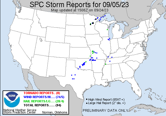
| Tornado Reports (CSV) (Raw Tornado CSV)(?) |
|---|
| No reports received |
| Hail Reports (CSV) (Raw Hail CSV)(?) |
|---|
Time | Size | Location | County | State | Lat | Lon | Comments |
| 2050 | 100 | Hoyt Lakes | St. Louis | MN | 4751 | 9215 | (DLH) |
| 2111 | 200 | 1 NNE Fort Ripley | Crow Wing | MN | 4618 | 9435 | Photo was received showing hail with a quarter with the hail being about twice as large as the quarter in diameter. (DLH) |
| 2125 | 125 | 1 W Barrows | Crow Wing | MN | 4630 | 9428 | (DLH) |
| 2215 | 150 | 3 NE Southeast Memphis | Shelby | TN | 3510 | 8985 | Caller reported large hail up to ping-pong size lasting approximately 5 minutes resulting in small dents on their car. (MEG) |
| 2302 | 150 | 5 NE Glen | Aitkin | MN | 4648 | 9345 | (DLH) |
| 2305 | 200 | 4 S Kimberly | Aitkin | MN | 4650 | 9348 | Photo sent in via social media of egg sized hail measured next to a golf ball. (DLH) |
| 2320 | 150 | 5 SE Lake Lafayette | Johnson | MO | 3890 | 9391 | (EAX) |
| 2322 | 200 | Mcgregor | Aitkin | MN | 4661 | 9331 | Report via social media with photo. Observer states they had hail of all sizes up to golf ball and egg size shown in photo. (DLH) |
| 2326 | 275 | 3 SSE Mcgregor | Aitkin | MN | 4656 | 9328 | (DLH) |
| 2333 | 100 | Kingsville | Johnson | MO | 3874 | 9407 | (EAX) |
| 2335 | 150 | Kingsville | Johnson | MO | 3874 | 9407 | (EAX) |
| 2345 | 100 | Holden | Johnson | MO | 3871 | 9399 | Report from mPING: Quarter (1.00 in.). (EAX) |
| 0012 | 125 | 5 S Mannford | Creek | OK | 3606 | 9634 | (TSA) |
| 0013 | 100 | Girard | Crawford | KS | 3751 | 9484 | social media picture of hail in Girard. (SGF) |
| 0014 | 100 | 5 SSW Mannford | Creek | OK | 3606 | 9637 | Report from mPING: Quarter (1.00 in.). (TSA) |
| 0051 | 100 | 1 E Windsor | Henry | MO | 3853 | 9351 | (EAX) |
| 0054 | 100 | 5 ENE Lake Lawtonka | Comanche | OK | 3478 | 9842 | (OUN) |
| 0058 | 100 | Montrose | Henry | MO | 3826 | 9398 | (EAX) |
| 0208 | 150 | 2 WSW Bethel Acres | Pottawatomie | OK | 3529 | 9709 | Social media picture. Location estimated by radar. (OUN) |
| 1103 | 100 | 3 SW De Pere | Brown | WI | 4442 | 8809 | (GRB) |
| Wind Reports (CSV) (Raw Wind CSV)(?) |
|---|
Time | Speed | Location | County | State | Lat | Lon | Comments |
| 1956 | UNK | 1 NE Iron Junction | St. Louis | MN | 4743 | 9259 | Numerous trees were down onto power lines just off County Road 7 near Old Mesaba and Ramshaw Roads and the railroad tracks. Tree limbs ranged in diameter from 4 to 12 i (DLH) |
| 2020 | UNK | 6 SSE Mckinley | St. Louis | MN | 4745 | 9234 | Strong winds with storms knocked several trees down along Vermilion Trail. (DLH) |
| 2030 | UNK | 4 N Makinen | St. Louis | MN | 4742 | 9235 | Report via social media with photos. Several small to medium sized trees down and reported power lines down as well. Time estimated from report and radar. (DLH) |
| 2030 | UNK | 6 SE Mckinley | St. Louis | MN | 4744 | 9233 | Numerous trees uprooted or snapped off along Bass Lake Rd. Time estimated off radar. (DLH) |
| 2031 | 107 | 5 S Aurora | St. Louis | MN | 4746 | 9224 | Numerous 12+ inch diameter pine trees snapped or uprooted. Trees downed on an outbuilding. Tree diameter estimated by photos. Time estimated by radar. (DLH) |
| 2032 | 88 | 5 S Aurora | St. Louis | MN | 4747 | 9224 | 12-18 inch diameter pine trees snapped. Diameter estimated from photo. Time estimated by radar. (DLH) |
| 2032 | 70 | 5 S Aurora | St. Louis | MN | 4747 | 9225 | Vinyl siding pealed off of a garage. (DLH) |
| 2040 | UNK | Hoyt Lakes | St. Louis | MN | 4751 | 9215 | Photos were received showing large tree limbs down in Hoyt Lakes. One limb looked to be at least 2 feet in diameter. (DLH) |
| 2042 | 94 | 1 NE Hoyt Lakes | St. Louis | MN | 4752 | 9214 | Large evergreen tree uprooted and fell on a garage. Estimated diameter of the tree is 14 to 18 inches from the photo. Time estimated by radar. (DLH) |
| 2043 | 93 | 3 ESE Hoyt Lakes | St. Louis | MN | 4750 | 9210 | Multiple 8-12 inch diameter pine trees uprooted. Diameter estimated by photos. Time estimated by radar. (DLH) |
| 2045 | 90 | 3 W Skibo | St. Louis | MN | 4749 | 9206 | Multiple 8-10 inch pine and aspen trees snapped or uprooted. Diameter estimated by photos. Time estimated by radar. (DLH) |
| 2109 | UNK | 4 NNE Lovelaceville | McCracken | KY | 3701 | 8879 | Late report. A large oak tree was uprooted and another large tree was snapped at its base. Several other large limbs down. Damage occurred at 1230 Gholson Rd. (PAH) |
| 2117 | UNK | 12 WNW Isabella | Lake | MN | 4770 | 9159 | Storm blew the top of a white pine off. Time estimated off radar. (DLH) |
| 2125 | UNK | 14 W Isabella | Lake | MN | 4759 | 9165 | Many large trees snapped off 10 feet above ground. Trees uprooted in areas with thin or wet soils. Tree limb through metal roof of cabin. (DLH) |
| 2125 | UNK | 14 WNW Isabella | Lake | MN | 4769 | 9164 | Several large trees snapped and 24 inch tree uprooted. (DLH) |
| 2138 | UNK | 3 ENE Forest Center | Lake | MN | 4781 | 9125 | Numerous trees were reported down on Boga Lake in the BWCA. Time estimated from radar. (DLH) |
| 2145 | UNK | 3 ENE Forest Center | Lake | MN | 4781 | 9125 | Trees down around a campsite. Picture of a large tree snapped. Report seen on Twitter. Time estimated by radar. (DLH) |
| 2243 | UNK | 3 NNW Glory | Aitkin | MN | 4646 | 9364 | Several trees snapped off. Report and photos via social media. Time estimated off radar. (DLH) |
| 2245 | UNK | 1 SE Wellston | Lincoln | OK | 3568 | 9706 | Delayed report. The back porch of a residence was lofted ... landing on a portion of the roof. Radar estimated time. (OUN) |
| 2245 | UNK | Wellston | Lincoln | OK | 3569 | 9706 | Large tree split in half and power pole damage. Time estimated via radar. (OUN) |
| 2245 | UNK | Wellston | Lincoln | OK | 3569 | 9707 | Powerlines reported down throughout the city of Wellston. Time estimated via radar. (OUN) |
| 2250 | UNK | 4 NNW Glory | Aitkin | MN | 4648 | 9362 | Photos showing four pine tree trunks snapped about halfway up. Trees estimated one foot in diameter. (DLH) |
| 2306 | UNK | 1 WNW Wildersville | Henderson | TN | 3579 | 8838 | Trees down at intersection of Battleground Dr. and Wildersville Road just south of I-40. Time is radar estimated. (MEG) |
| 2310 | UNK | 4 N Chandler | Lincoln | OK | 3576 | 9689 | Delayed report. Damage to the roof and exterior wall of a residence. Radar estimated time. (OUN) |
| 2310 | 63 | 13 NE Sand Bay | Ashland | WI | 4708 | 9073 | Corrects previous non-tstm wnd gst report from 13 NE Sand Bay. Mesonet station DISW3 Devils Island. Marine thunderstorm wind gust from peak gust measurement. (DLH) |
| 2315 | 70 | 25 SE Lutsen | LSZ162 | MN | 4740 | 9032 | 61 knot wind gust measured on the Dirk S. VanEnkevort with a sustained wind speed of 54 knots. (DLH) |
| 2320 | UNK | 2 SE Kendrick | Lincoln | OK | 3577 | 9676 | Delayed report. Damage to a metal shed and fence. Radar estimated time. (OUN) |
| 2324 | 68 | Westbrook | Mitchell | TX | 3235 | 10102 | Mesonet station UR164 Westbrook (UPR). (MAF) |
| 2324 | UNK | 4 SSW Hopkinsville | Christian | KY | 3680 | 8752 | Corrects previous tstm wnd dmg report from 4 SSW Hopkinsville. Mostly tree damage reported near Gary Lane and Hillwood Circle. Possible tornado. (PAH) |
| 2325 | UNK | 5 NNW Harrah | Oklahoma | OK | 3557 | 9719 | Several power poles blown down. Time estimated via radar. (OUN) |
| 2335 | UNK | 2 WNW Hovland | Cook | MN | 4785 | 9002 | Multiple large trees down and power out. Time estimated from radar. (DLH) |
| 2345 | UNK | 4 NE Choctaw | Oklahoma | OK | 3553 | 9721 | Power line down. Time estimated via radar. (OUN) |
| 2350 | UNK | Harrah | Oklahoma | OK | 3549 | 9716 | Power pole snapped ... leaning on a building. Time estimated via radar. (OUN) |
| 2355 | UNK | 4 E Harrah | Lincoln | OK | 3549 | 9710 | *** 1 INJ *** Travel trailer blown over ... landing on a mobile home. Time estimated via radar. (OUN) |
| 2355 | UNK | 2 NNE Harrah | Oklahoma | OK | 3552 | 9715 | Delayed report. Four power poles snapped at the base. Radar estimated time. (OUN) |
| 2357 | UNK | 4 NNE Harrah | Lincoln | OK | 3555 | 9714 | Delayed report. Large tree blown down ... blocking a portion of the Pottawatomie and Wilshire Road intersection. Radar estimated time. (OUN) |
| 0000 | 60 | Newcastle | McClain | OK | 3525 | 9760 | Small tree limbs also reported down. (OUN) |
| 0020 | UNK | 5 WNW Aydelotte | Lincoln | OK | 3546 | 9700 | Delayed report. Powerlines down near the intersection of Highway 177 and E 1070 Road. Radar estimated time. (OUN) |
| 0025 | 61 | 2 ENE Whiteman Air Forc | Johnson | MO | 3874 | 9352 | Home weather station just east of Whiteman AFB. (EAX) |
| 0028 | UNK | 1 E Haynesville | Wichita | TX | 3409 | 9890 | Downburst caused damage to power lines ... fences ... and several buildings including one home. Time estimated by radar. (OUN) |
| 0030 | UNK | 2 NNW Bethel Acres | Pottawatomie | OK | 3533 | 9707 | Picture showing a portion of a roof removed from a mobile home. (OUN) |
| 0030 | UNK | 5 ENE Rock of Ages | LSZ263 | MI | 4791 | 8916 | Corrects previous tstm wnd dmg report from 5 ENE Rock of Ages; time of damage is estimated by nearby observations. National Park Service in Isle Royale reported a tree (MQT) |
| 0100 | UNK | 2 SSW Lake Ellsworth | Comanche | OK | 3480 | 9837 | Delayed report. Three boathouses damaged on Lake Ellsworth. Radar estimated time. (OUN) |
| 0105 | UNK | 5 N Fort Sill | Comanche | OK | 3473 | 9841 | Public reported very strong winds which resulted in tree damage. (OUN) |
| 0108 | 60 | Tecumseh | Pottawatomie | OK | 3526 | 9694 | (OUN) |
| 0139 | 70 | 48 ENE Rock of Ages | LSZ264 | MI | 4822 | 8837 | C-MAN station PILM4 53 NNW Eagle Harbor. (MQT) |
| 0140 | UNK | Geronimo | Comanche | OK | 3448 | 9838 | Delayed report. Roof removed from a mobile home. Radar estimated time. (OUN) |
| 0150 | UNK | 2 W Stover | Morgan | MO | 3844 | 9302 | A tree was reported downed at Highway 52 and Highway 135. Another tree was downed in Versailles and the Ivy Bend area in Morgan CO. (SGF) |
| 0200 | UNK | 1 W Pensacola | Mayes | OK | 3645 | 9515 | Strong thunderstorm wind snapped large tree limbs ... and blew down power lines. (TSA) |
| 0207 | UNK | 1 SW Duquesne | Jasper | MO | 3707 | 9447 | Reported damage to a metal building. (SGF) |
| 0210 | UNK | 4 W Tye | Taylor | TX | 3246 | 9993 | Damage occurred to multiple buildings at Taylor Electric Coop facility. Roofing peeled back ... garage doors bent and imploded ... and power poles knocked down. (Delayed (SJT) |
| 0210 | UNK | Langley | Mayes | OK | 3646 | 9506 | Strong thunderstorm wind damaged a restaurant ... snapped large tree limbs ... and blew down power lines. (TSA) |
| 0215 | UNK | Grove | Delaware | OK | 3659 | 9477 | Extensive damage to storage building. Boat dock also damaged. (TSA) |
| 0222 | UNK | Eldon | Miller | MO | 3835 | 9258 | Reports of trees downed in Eldon and Tuscumbia. (SGF) |
| 0227 | UNK | 3 SW Grove | Delaware | OK | 3656 | 9480 | Dock and boat damage at the Grand Lake Sailing Club (Diller cove). (TSA) |
| 0235 | UNK | 3 ENE Washington | McClain | OK | 3507 | 9743 | Large tree limbs blown down. Radar estimated time. (OUN) |
| 0237 | UNK | 2 S Sarcoxie | Newton | MO | 3704 | 9412 | Delayed report 2 miles S of Sarcoxie on Racoon Rd 4 inch limbs approximately 8 inches long down. (SGF) |
| 0240 | UNK | 1 NW Lake Thunderbird | Cleveland | OK | 3524 | 9724 | Several trees damaged near Indian Point Rd. (near Thunderbird Boathouse). Time estimated by radar. (OUN) |
| 0245 | UNK | 7 NW Tankersley | Irion | TX | 3142 | 10073 | Small tree limbs down ... winds estimated over 60 MPH. (SJT) |
| 0250 | UNK | 3 W Pink | Cleveland | OK | 3525 | 9717 | Trees down near Harrah Rd and E Tecumseh Rd. Radar estimated time. (OUN) |
| 0253 | UNK | 2 NNE Pink | Pottawatomie | OK | 3529 | 9711 | Siding removed from barn with debris strewn across property. Time estimated by radar. (OUN) |
| 0255 | 58 | 2 E Wall | Tom Green | TX | 3138 | 10027 | West Texas Mesonet site 2 E Wall measured a 58 mph wind gust. (SJT) |
| 0354 | UNK | Washburn | Barry | MO | 3659 | 9396 | Delayed Report. Tree branches around 6 inches snapped ... and power out through Washburn and Seligman. (SGF) |
| 0355 | 60 | 2 ENE Grove | Delaware | OK | 3660 | 9474 | (TSA) |
| 0451 | 59 | 2 SW Bentonville | Benton | AR | 3635 | 9423 | (TSA) |
| 0453 | UNK | Bentonville | Benton | AR | 3637 | 9420 | Trees down and damage to a gazebo. (TSA) |
| 0505 | UNK | Ava | Douglas | MO | 3696 | 9266 | Large limb downed on a home in Ava. (SGF) |
| 0510 | UNK | Bland | Benton | AR | 3633 | 9393 | Strong thunderstorm wind blew down a tree. Time estimated based on radar. Report through broadcast media. (TSA) |
| 0543 | UNK | Berryville | Carroll | AR | 3637 | 9357 | Several trees and power lines down. (TSA) |
| 0600 | UNK | 1 NNE Bear Creek Spring | Boone | AR | 3631 | 9318 | This is a delayed report. A large tree was blown over. (LZK) |
| 0926 | UNK | 1 SSW Naperville | DuPage | IL | 4176 | 8815 | Photo shared on social media showing a snapped tree near Edward Hospital in Naperville. Other tree damage also observed in the area. Time estimated from radar. (LOT) |
| 0928 | UNK | 1 ESE Naperville | DuPage | IL | 4177 | 8812 | Report relayed via social media of small to medium size branches downed in Naperville. Time estimated by radar. (LOT) |
| 1050 | 60 | 3 NE Navy Pier | LMZ741 | IL | 4192 | 8757 | (LOT) |
| 1058 | 60 | 2 NE Orland Hills | Cook | IL | 4161 | 8782 | (LOT) |


 @NWSSPC