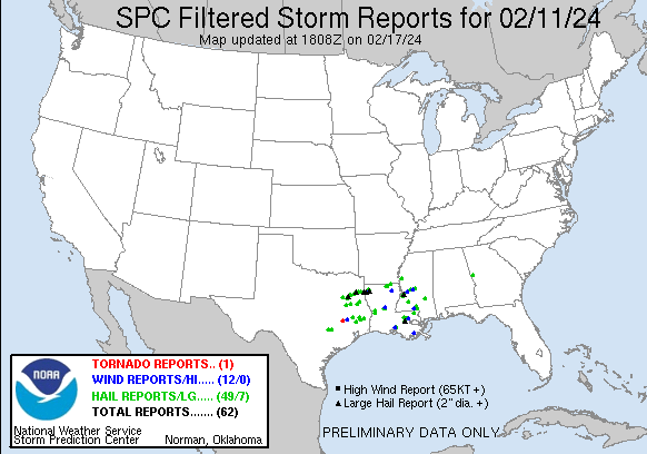
| Tornado Reports (CSV) (Raw Tornado CSV)(?) |
|---|
Time | | Location | County | State | Lat | Lon | Comments |
| 1505 | | 2 NNW Richards | Grimes | TX | 3057 | 9584 | Storm spotter reported a brief thin tornado just east of FM 1486 Rd near Richards ... TX at 9:05am. (HGX) |
| Hail Reports (CSV) (Raw Hail CSV)(?) |
|---|
Time | Size | Location | County | State | Lat | Lon | Comments |
| 1220 | 150 | 1 ENE Athens | Henderson | TX | 3221 | 9584 | Picture of 1.5 hail from Athens. (FWD) |
| 1240 | 100 | 1 SW Coffee City | Henderson | TX | 3212 | 9549 | Report from mPING: Quarter (1.00 in.). (FWD) |
| 1240 | 100 | 4 ENE Moore Station | Henderson | TX | 3222 | 9551 | Quarter size hail reported in the Forest Grove POA. (FWD) |
| 1249 | 175 | 1 SW Noonday | Smith | TX | 3224 | 9541 | Golf ball sized hail in Noonday. (SHV) |
| 1249 | 175 | Noonday | Smith | TX | 3224 | 9540 | Golf ball size hail northeast of Bullard. (SHV) |
| 1250 | 150 | 6 SSW Noonday | Smith | TX | 3216 | 9544 | (SHV) |
| 1251 | 150 | 4 SSW Tyler | Smith | TX | 3228 | 9533 | Ping pong ball sized hail reported at West Grand Blvd and Old Jacksonville Hwy. (SHV) |
| 1253 | 200 | 2 SW Tyler | Smith | TX | 3231 | 9534 | Hail to near egg size at County Road 155 and Loop 323. (SHV) |
| 1257 | 275 | 1 NE Noonday | Smith | TX | 3225 | 9539 | Report of baseball size hail with cars damaged along 155 and loop 49. (SHV) |
| 1257 | 100 | 3 SSW Tyler | Smith | TX | 3229 | 9531 | Report from mPING: Quarter (1.00 in.). (SHV) |
| 1258 | 150 | 3 SSE Tyler | Smith | TX | 3230 | 9528 | Report from mPING: Ping Pong Ball (1.50 in.). (SHV) |
| 1258 | 125 | 3 E Tyler | Smith | TX | 3233 | 9525 | Report from mPING: Half Dollar (1.25 in.). (SHV) |
| 1300 | 150 | Tyler | Smith | TX | 3233 | 9530 | Widespread 1.5 inch sized hail across all of South Tyler attm. (SHV) |
| 1309 | 150 | 1 WNW New Chapel Hill | Smith | TX | 3231 | 9518 | Report relayed to us with a picture. (SHV) |
| 1324 | 175 | Tyler | Smith | TX | 3232 | 9530 | Report from HAM operator. (SHV) |
| 1332 | 100 | 1 SSE Kilgore | Gregg | TX | 3238 | 9486 | Report via social media from HAM operator. (SHV) |
| 1333 | 250 | 1 NNE Kilgore | Gregg | TX | 3240 | 9486 | Report via social media with picture. (SHV) |
| 1340 | 100 | 2 S Elkhart | Anderson | TX | 3161 | 9558 | Report from mPING: Quarter (1.00 in.). (FWD) |
| 1340 | 125 | 2 ESE Elkhart | Anderson | TX | 3162 | 9555 | Nickel to half dollar size reported near Elkhart. (FWD) |
| 1344 | 275 | 2 ESE Longview | Gregg | TX | 3250 | 9473 | Report via social media with a picture. (SHV) |
| 1347 | 275 | 2 ESE Longview | Gregg | TX | 3250 | 9473 | Corrects previous hail report from 2 ESE Longview with a corrected time. Report via social media with a picture. (SHV) |
| 1407 | 100 | 1 SSW Hallsville | Harrison | TX | 3249 | 9458 | Hailing for over 10 minutes. (SHV) |
| 1422 | 100 | 6 WNW Alto | Cherokee | TX | 3170 | 9516 | Reports of quarter sized hail 7 miles to the south of Rusk. (SHV) |
| 1423 | 175 | 3 S Marshall | Harrison | TX | 3249 | 9436 | Reports of Golf Ball Sized hail at I-20 and HWY 59 south of Marshall. (SHV) |
| 1426 | 150 | 1 NNW Marshall | Harrison | TX | 3255 | 9435 | Reports of Ping Pong ball sized hail falling in Marshall. (SHV) |
| 1430 | 250 | 2 W Waskom | Harrison | TX | 3248 | 9410 | Report from mPING: Tennis Ball (2.50 in.). (SHV) |
| 1432 | 175 | 9 WNW La Grange | Fayette | TX | 2994 | 9702 | Public report of hail up to golf ball size near the intersection of State Highway 71 and Justice Road. (EWX) |
| 1450 | 175 | 3 ENE Shreveport | Caddo | LA | 3249 | 9375 | Golf ball sized hail reported at the KSLA studios on north Line Avenue. (SHV) |
| 1450 | 150 | Blanchard | Caddo | LA | 3258 | 9389 | Hail measured in Blanchard ... Louisiana. (SHV) |
| 1456 | 175 | 3 WSW Appleby | Nacogdoches | TX | 3170 | 9466 | Corrects time of previous hail report from 3 WSW Appleby. Reports of Golf Ball size hail north of Nacogdoches. (SHV) |
| 1459 | 125 | 7 SW Round Top | Fayette | TX | 2999 | 9678 | Report from mPING Half Dollar (1.25 in.). (EWX) |
| 1501 | 200 | 5 WNW Shreveport | Caddo | LA | 3250 | 9387 | Reports of 2 inch hail near Cross Lake. (SHV) |
| 1503 | 150 | 3 ENE Blanchard | Caddo | LA | 3260 | 9384 | Report from mPING: Ping Pong Ball (1.50 in.). (SHV) |
| 1507 | 100 | 1 N Garrison | Nacogdoches | TX | 3183 | 9449 | Report of Nickel to Quarter sized hail. (SHV) |
| 1510 | 175 | 6 ESE Benton | Bossier | LA | 3266 | 9365 | Golf ball sized hail reported on the southeast side of Cypress Lake. (SHV) |
| 1513 | 150 | 4 S Benton | Bossier | LA | 3264 | 9374 | Report from mPING: Ping Pong Ball (1.50 in.). (SHV) |
| 1515 | 300 | 2 W Red Chute | Bossier | LA | 3257 | 9365 | Hail lasted about 2 min. measured 3 in hail with ruler. (SHV) |
| 1515 | 100 | 3 N Bossier City | Bossier | LA | 3257 | 9372 | Quarter sized hail in north bossier. (SHV) |
| 1515 | 150 | 5 S Benton | Bossier | LA | 3262 | 9373 | Report through social media. (SHV) |
| 1515 | 100 | 1 S Benton | Bossier | LA | 3268 | 9374 | NWS employee measured 1 inch hail off Lost River Dr. near Benton ... Louisiana. (SHV) |
| 1517 | 200 | 2 WNW Red Chute | Bossier | LA | 3258 | 9364 | Report from mPING: Hen Egg (2.00 in.). (SHV) |
| 1530 | 125 | 6 WNW Red Chute | Bossier | LA | 3262 | 9370 | Delayed Report. (SHV) |
| 1556 | 175 | 3 WSW Appleby | Nacogdoches | TX | 3170 | 9466 | Reports of Golf Ball size hail north of Nacogdoches. (SHV) |
| 1630 | 150 | 2 E Onalaska | Polk | TX | 3081 | 9507 | Spotter reports ping pong size hail. (HGX) |
| 1650 | 100 | 6 SSE Marion | Union | LA | 3281 | 9220 | Hail near quarter size reported near the Linville community. (SHV) |
| 1718 | 150 | 7 SE Marion | Union | LA | 3283 | 9215 | Report from EM with supporting picture. (SHV) |
| 1719 | 100 | 1 WNW Beekman | Morehouse | LA | 3293 | 9190 | (JAN) |
| 1844 | 100 | Arcola | Washington | MS | 3327 | 9088 | Dime to quarter sized hail fell. (JAN) |
| 1900 | 125 | 15 ESE Shepherd | Liberty | TX | 3044 | 9477 | Report from mPING: Half Dollar (1.25 in.). (HGX) |
| 1900 | 100 | 5 W Woodville | Tyler | TX | 3076 | 9451 | Quarter size hail. (LCH) |
| 1939 | 100 | Warren | Tyler | TX | 3061 | 9440 | Picture on Slack. (LCH) |
| 2005 | 100 | Spurger | Tyler | TX | 3069 | 9418 | Video on Twitter. (LCH) |
| 2015 | 175 | Spurger | Tyler | TX | 3069 | 9418 | Multiple photos received of hail up to golf ball size in the city of Spurger. (LCH) |
| 2035 | 100 | 1 NE Leesville | Vernon | LA | 3114 | 9327 | Report of hail from Twitter. (LCH) |
| 2125 | 100 | Pickering | Vernon | LA | 3103 | 9327 | Social media video shows nickel to quarter size hail. Video not in the core of the storm. (LCH) |
| 2229 | 100 | 1 NW Alexandria | Rapides | LA | 3131 | 9248 | Public reports Quarter size hail. (LCH) |
| 2250 | 125 | Alexandria | Rapides | LA | 3129 | 9246 | media reported multiple hail reports of 1 to 1.25 inches. (LCH) |
| 2311 | 175 | 5 E Grand Gulf Military | Claiborne | MS | 3205 | 9096 | Reported in the Shiloh community. (JAN) |
| 2314 | 200 | 6 ESE LeTourneau | Warren | MS | 3219 | 9084 | Social media photo taken along Dudley Rd. (JAN) |
| 2340 | 100 | Pocahontas | Hinds | MS | 3247 | 9029 | (JAN) |
| 0030 | 175 | 2 NNW Goshen Springs | Rankin | MS | 3250 | 8992 | (JAN) |
| 0344 | 100 | Livingston | Livingston | LA | 3050 | 9075 | Public report from Livingston of quarter-sized hail ... winds estimated 40mph and power out. (LIX) |
| 0425 | 100 | 2 NNE Watson | Livingston | LA | 3060 | 9094 | Quarter sized hail starting approx. 10:25 PM lasting for roughly 10 minutes. (LIX) |
| 0445 | 175 | 1 NNE Hurricane Creek | Marion | MS | 3112 | 8987 | Report via social media. Quarter to golfball size hail near Sandy Hook. (JAN) |
| 0513 | 150 | 3 E Jeanerette | St. Mary | LA | 2992 | 9163 | picture sent by EM. (LCH) |
| 0555 | 175 | 2 NNW Foxworth | Marion | MS | 3126 | 8988 | Ping pong to golfball size hail near Foxworth. (JAN) |
| 0556 | 150 | 2 SSE Expose | Marion | MS | 3130 | 8985 | Hail larger than a quarter along MS Highway 13 north of Columbia. (JAN) |
| 0558 | 100 | 3 NNE Smiths Crossroad | Troup | GA | 3299 | 8500 | Deputies reporting quarter size hail on Hamilton Rd at Sam Walker Dr. (FFC) |
| 0602 | 100 | Prairieville | Ascension | LA | 3030 | 9097 | Photo of hail ... estimated to be around quarter sized. Location in Prairieville off Highway 73. Time estimated from radar. (LIX) |
| 0605 | 150 | Prairieville | Ascension | LA | 3030 | 9097 | 1.5 inch hail (Walnut sized) reported. Small tree limbs down less than 2 inches diameter. (LIX) |
| 0607 | 100 | 4 E Prairieville | Ascension | LA | 3031 | 9091 | Report from mPING: Quarter (1.00 in.). (LIX) |
| 0607 | 175 | 3 ENE Prairieville | Ascension | LA | 3032 | 9093 | Picture of golf ball sized hail by Prairieville High School. Time estimated from radar. (LIX) |
| 0610 | 200 | 2 ENE Prairieville | Ascension | LA | 3031 | 9093 | Photo of hail in various sizes next to a penny ... quarter ... ping pong ball and ruler. Largest hail stone is oddly shaped and may be upwards of 2 inches in diameter or (LIX) |
| 0616 | 175 | 8 ENE Prairieville | Livingston | LA | 3036 | 9086 | Social media report of quarter to golf ball sized hail between Walker and Port Vincent. (LIX) |
| 0619 | 175 | 8 ENE Prairieville | Livingston | LA | 3034 | 9085 | Social media report of golf ball sized hail in Port Vincent. (LIX) |
| 0622 | 100 | West Lincoln | Lincoln | MS | 3149 | 9057 | Report via social media. (JAN) |
| 0625 | 100 | 2 S Zetus | Lincoln | MS | 3153 | 9053 | Occurred along US 84 west of Brookhaven. (JAN) |
| 0628 | 175 | 2 W Livingston | Livingston | LA | 3051 | 9077 | Estimated hail size. Tree Limbs also broken. (LIX) |
| 0630 | 125 | 2 NW Brookhaven | Lincoln | MS | 3160 | 9047 | Video submitted via social media. (JAN) |
| 0634 | 150 | 3 E Livingston | Livingston | LA | 3051 | 9070 | Photo from the public of around ping pong ball sized hail ... estimated. Time estimated from radar. (LIX) |
| 0655 | 100 | 1 S Sharon | Jones | MS | 3177 | 8910 | Report of quarter size hail. Report relayed to broadcast media via public. (JAN) |
| 0723 | 100 | 1 S Franklinton | Washington | LA | 3083 | 9014 | MPing report of 1 inch hail near Franklinton. Time estimated from radar. (LIX) |
| Wind Reports (CSV) (Raw Wind CSV)(?) |
|---|
Time | Speed | Location | County | State | Lat | Lon | Comments |
| 1500 | 59 | 3 SW Shreveport | Caddo | LA | 3245 | 9383 | ASOS station KSHV Shreveport Regional Airport. (SHV) |
| 1513 | 62 | 1 ESE Barksdale Air For | Bossier | LA | 3250 | 9367 | AWOS station KBAD Barksdale AFB. (SHV) |
| 1542 | UNK | 5 NNW New Waverly | Walker | TX | 3060 | 9551 | Social Media report of damage along I-45 near New Waverly. Limbs down and a roof removed from a bard and sent into the median. (HGX) |
| 1810 | UNK | Girard | Richland | LA | 3248 | 9180 | A couple trees were snapped near Girard. (JAN) |
| 2020 | UNK | 2 E Madison | Madison | MS | 3247 | 9008 | Tree downed over Hoy Rd. (JAN) |
| 2040 | UNK | 3 S Bolton | Hinds | MS | 3231 | 9046 | A tree was down blocking the road on Raymond-Bolton Road near Houston Road. (JAN) |
| 2040 | UNK | 4 E Edwards | Hinds | MS | 3233 | 9053 | A tree was down blocking a roadway on Billy Fields Road near DJ Johnson Road. (JAN) |
| 2240 | UNK | 2 NW Pineville | Rapides | LA | 3135 | 9243 | Photo received of tree blown down onto fence in Pineville. Time estimated by radar. (LCH) |
| 0219 | UNK | 1 SSE Lydia | Iberia | LA | 2991 | 9178 | Corrects time of previous tstm wnd dmg report from 1 SSE Lydia. Power outages reported in the community of Lydia. Outage occurred at the time of large hail core falling (LCH) |
| 0314 | UNK | 1 SSE Lydia | Iberia | LA | 2991 | 9178 | Power outages reported in the community of Lydia. Outage occurred at the time of large hail core falling out of storm. (LCH) |
| 0536 | UNK | 1 SW Tylertown | Walthall | MS | 3111 | 9015 | Photos/Report from the public and local county EM of damage to Tylertown High School. Pictures indicate roof damage. Also report of trees down. Time estimated from rada (LIX) |
| 0637 | UNK | 6 NNW Springfield | Livingston | LA | 3051 | 9058 | Multiple trees and power lines down along N. Montpelier Rd between Jacob St and Sziszak St. (LIX) |
| 1015 | 60 | 3 ENE Galliano | Lafourche | LA | 2945 | 9026 | GAO (South Lafourche Airport) recorded a wind gust of 60 mph. (LIX) |


 @NWSSPC