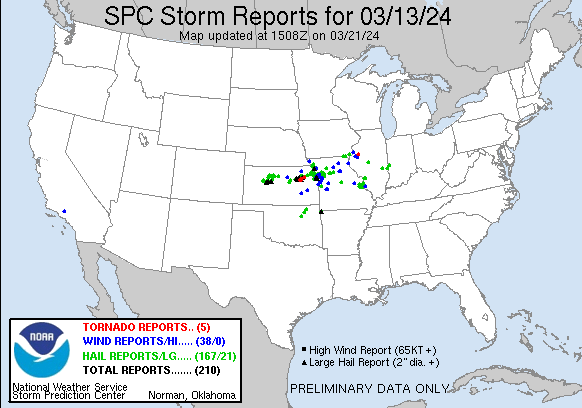
| Tornado Reports (CSV) (Raw Tornado CSV)(?) |
|---|
Time | | Location | County | State | Lat | Lon | Comments |
| 0050 | | 3 NE Alta Vista | Wabaunsee | KS | 3889 | 9645 | (TOP) |
| 0102 | | Volland | Wabaunsee | KS | 3895 | 9640 | Delayed report: 1 rancher reported 5 barns damaged ... but no damage to his residence. Time estimated from radar. (TOP) |
| 0115 | | 4 SW Alma | Wabaunsee | KS | 3898 | 9634 | Law Enformcement reporting a tornado on the ground. (TOP) |
| 0133 | | 1 NW Rossville | Shawnee | KS | 3915 | 9596 | Public reports relayed by Emergency Management of a tornado on the ground at 62nd and Valencia near Rossvile. (TOP) |
| 0936 | | 5 N Prairie City | Warren | IL | 4069 | 9045 | A brief tornado developed early Thursday morning ... just northwest of Avon in Warren County Illinois. The tornado caused significant damage at two farmsteads ... which i (DVN) |
| Hail Reports (CSV) (Raw Hail CSV)(?) |
|---|
Time | Size | Location | County | State | Lat | Lon | Comments |
| 2115 | 100 | Hillsboro | Jefferson | MO | 3823 | 9056 | Relayed via broadcast media ... time estimated from radar. (LSX) |
| 2129 | 100 | 1 W Olympian Village | Jefferson | MO | 3814 | 9047 | (LSX) |
| 2140 | 100 | 2 SSE Festus | Jefferson | MO | 3819 | 9039 | Relayed via broadcast media. (LSX) |
| 2142 | 150 | 1 S Crystal City | Jefferson | MO | 3821 | 9039 | Relayed via broadcast media from public ... time estimated via radar. (LSX) |
| 2150 | 150 | 5 E Olympian Village | Jefferson | MO | 3813 | 9036 | Reported as just under golf ball size hail. (LSX) |
| 2153 | 100 | 6 SSE Crystal City | Jefferson | MO | 3814 | 9033 | (LSX) |
| 2153 | 125 | 5 SSE Crystal City | Jefferson | MO | 3816 | 9034 | Report from mPING: Half Dollar (1.25 in.). (LSX) |
| 2232 | 100 | 1 SE Renault | Monroe | IL | 3814 | 9011 | (LSX) |
| 2236 | 100 | 2 W Ames | Monroe | IL | 3814 | 9009 | Report from mPING: Quarter (1.00 in.). (LSX) |
| 2241 | 100 | 1 S Cedar Hill | Jefferson | MO | 3834 | 9064 | (LSX) |
| 2247 | 100 | 1 W Ruma | Randolph | IL | 3813 | 9001 | Hail was mostly the size of pennies and dimes ... but observer did see quarter size hail mixed in. (LSX) |
| 2249 | 175 | Ames | Monroe | IL | 3815 | 9005 | (LSX) |
| 2250 | 175 | Ruma | Randolph | IL | 3813 | 9000 | (LSX) |
| 2251 | 175 | Renault | Monroe | IL | 3815 | 9013 | (LSX) |
| 2353 | 100 | 2 ESE Columbia | Monroe | IL | 3845 | 9019 | (LSX) |
| 2355 | 175 | 8 SSW Palco | Rooks | KS | 3914 | 9959 | Public report of hail up to golf ball size one mile in from very southwest corner of Rooks County. Time estimated from radar. (GID) |
| 0001 | 100 | 4 WNW Gypsum | Saline | KS | 3873 | 9749 | 10 minutes of hail ... pea to quarter sized ... hail completely covering ground. (ICT) |
| 0011 | 100 | 12 S Collyer | Trego | KS | 3887 | 10012 | (DDC) |
| 0011 | 100 | 1 S Linwood | Leavenworth | KS | 3899 | 9504 | Quarter sized hail reported just south of Linwood. Time estimated from radar. (EAX) |
| 0018 | 125 | 2 NW Zurich | Rooks | KS | 3925 | 9945 | Hail up to half dollar size ongoing. (GID) |
| 0021 | 100 | 1 NW Clearview City | Johnson | KS | 3896 | 9502 | Quarter sized hail at the intersection of State Highway 10 and Edgerton Road. (EAX) |
| 0022 | 100 | 10 SW Trego Center | Trego | KS | 3880 | 10005 | (DDC) |
| 0022 | 100 | 6 E New Cambria | Saline | KS | 3889 | 9739 | mostly small hail ... a few quarter sized. (ICT) |
| 0024 | 125 | Saint Martins | Cole | MO | 3860 | 9233 | (LSX) |
| 0030 | 175 | 3 N Dwight | Geary | KS | 3888 | 9659 | Delayed report. 1.75 inch hail near the Geary Morris County line north of Dwight. Time estimated from radar. (TOP) |
| 0030 | 100 | De Soto | Johnson | KS | 3898 | 9497 | A resident reported quarter sized hail in De Soto. Time confirmed from radar. (EAX) |
| 0034 | 100 | Elston | Cole | MO | 3861 | 9232 | Time estimated via radar. (LSX) |
| 0034 | 150 | Alma | Wabaunsee | KS | 3902 | 9629 | Ping Pong Ball size hail reported in Alma. (TOP) |
| 0036 | 100 | 6 SW Trego Center | Trego | KS | 3882 | 9996 | (DDC) |
| 0036 | 100 | 1 N De Soto | Leavenworth | KS | 3900 | 9496 | Nickel to quarter sized hail at 166th Street and Golden Road. (EAX) |
| 0038 | 125 | 2 SE Shawnee | Johnson | KS | 3899 | 9478 | Photo of approximately half dollar size hail in the western side of Lenexa. Time estimated from radar. (EAX) |
| 0040 | 100 | 1 W De Soto | Johnson | KS | 3898 | 9499 | mPing report of quarter sized hail. Time confirmed from radar. (EAX) |
| 0045 | 100 | 3 NNE De Soto | Leavenworth | KS | 3901 | 9495 | Quarter sized hail near 158th Street and Loring Rd. (EAX) |
| 0046 | 125 | 9 S Trego Center | Trego | KS | 3876 | 9989 | (DDC) |
| 0050 | 250 | 2 W Shawnee | Johnson | KS | 3901 | 9484 | Hail up to tennis ball size near 64th Street and Brockway Street. Time estimated from radar. (EAX) |
| 0050 | 200 | 2 WNW Shawnee | Johnson | KS | 3902 | 9484 | Photo of two-inch diameter hail near Mill Valley High School. Time estimated from radar. (EAX) |
| 0050 | 150 | 3 ESE Zurich | Rooks | KS | 3922 | 9938 | (GID) |
| 0052 | 175 | Bonner Springs | Wyandotte | KS | 3906 | 9488 | Photo of golf ball sized hail in Bonner Springs. Time estimated from radar. (EAX) |
| 0054 | 175 | 1 WNW Shawnee | Johnson | KS | 3901 | 9484 | Golf ball sized hail at the intersection of 64th Street and Monticello Road. (EAX) |
| 0054 | 275 | 2 ESE Bonner Springs | Johnson | KS | 3904 | 9485 | Report from mPING: Baseball (2.75 in.). Time estimated from radar. (EAX) |
| 0054 | 125 | 3 SW Maywood | Jackson | MO | 3906 | 9449 | Report from mPING: Half Dollar (1.25 in.). Time estimated from radar. (EAX) |
| 0055 | 300 | 2 SSE Bonner Springs | Johnson | KS | 3903 | 9486 | Hail measured at 3.5 inches in diameter at 55th Street and McCormick Drive. Photo provided to trained spotter and relayed to the office. Time estimated from radar. (EAX) |
| 0055 | 125 | 2 WSW Maywood | Jackson | MO | 3908 | 9449 | Report from mPING: Half Dollar (1.25 in.). Time estimated from radar. (EAX) |
| 0055 | 175 | 2 WSW Maywood | Wyandotte | KS | 3912 | 9484 | Photo of golf ball size hail just north of Kansas Speedway. Time estimated from radar. (EAX) |
| 0057 | 275 | Shawnee | Johnson | KS | 3901 | 9481 | Photo of baseball sized hail in Shawnee. Time estimated from radar. (EAX) |
| 0057 | 200 | 1 W Edwardsville | Wyandotte | KS | 3906 | 9484 | Photo of two-inch diameter hail just west of Edwardsville. Time estimated from radar. (EAX) |
| 0057 | 150 | 3 WNW Fort Leavenworth | Leavenworth | KS | 3938 | 9496 | Inch and a half sized hail reported at 167th/Coffin Road North of Fort Leavenworth ... KS (Leavenworth County). (EAX) |
| 0100 | 200 | 2 SSE Lake Quivira | Johnson | KS | 3901 | 9476 | Two inch hail in Mill Valley with broken windshields. Time estimated from radar. (EAX) |
| 0100 | 200 | 1 WNW Shawnee | Johnson | KS | 3901 | 9483 | Photo of two inch diameter hail near 64th and Woodland. Time estimated from radar. (EAX) |
| 0100 | 250 | 1 WNW Shawnee | Johnson | KS | 3901 | 9484 | Photo of approximately tennis ball sized hail near 64th and Monticello. Time confirmed from radar. (EAX) |
| 0100 | 175 | 1 SW Kansas City | Jackson | MO | 3909 | 9459 | Severe thunderstorms with large hail and torrential rainfall resulted in temporary stranded traffic and road closures ... including on I-35 and I-70 ... between 730 and 9 (EAX) |
| 0101 | 100 | 1 NNW Maywood | Wyandotte | KS | 3915 | 9481 | Quarter size hail at 99th and Leavenworth Road in KCK. (EAX) |
| 0102 | 100 | Junction City | Geary | KS | 3903 | 9683 | (TOP) |
| 0102 | 275 | 2 ESE Bonner Springs | Johnson | KS | 3905 | 9485 | Baseball sized hail damaged car windows. Time estimated from radar. (EAX) |
| 0102 | 100 | 1 ESE Piper | Wyandotte | KS | 3914 | 9484 | Report from mPING: Quarter (1.00 in.). Time estimated from radar. (EAX) |
| 0102 | 125 | 2 NE Piper | Wyandotte | KS | 3916 | 9483 | Report from mPING: Half Dollar (1.25 in.). Time estimated from radar. (EAX) |
| 0103 | 150 | 3 SW Junction City | Geary | KS | 3900 | 9686 | (TOP) |
| 0103 | 150 | 1 NNW Maywood | Wyandotte | KS | 3914 | 9481 | Ping pong ball sized hail near 99th Street and Leavenworth Road. Time confirmed from radar. (EAX) |
| 0104 | 175 | 1 E Maywood | Wyandotte | KS | 3913 | 9479 | Report from mPING: Golf Ball (1.75 in.). Time estimated from radar. (EAX) |
| 0105 | 250 | Edwardsville | Wyandotte | KS | 3906 | 9482 | Broadcast media reports tennis ball sized hail in Edwardsville. Time confirmed from radar. (EAX) |
| 0107 | 125 | 3 SW Junction City | Geary | KS | 3900 | 9686 | Report from mPING: Half Dollar (1.25 in.). (TOP) |
| 0108 | 400 | 2 WSW Alma | Wabaunsee | KS | 3901 | 9632 | Softball size hail reported by law enforcement 2 WSW of Alma. (TOP) |
| 0110 | 100 | Mitchell | Madison | IL | 3876 | 9008 | (LSX) |
| 0110 | 100 | 3 SSW Cedar Bluff | Trego | KS | 3878 | 9975 | (DDC) |
| 0110 | 175 | 1 SE Maywood | Wyandotte | KS | 3911 | 9479 | 89th & Anne Ave ... . KCK Golf ball sized hail and heavy rain. (EAX) |
| 0110 | 100 | 1 NNE Plainville | Rooks | KS | 3924 | 9930 | Hail covering the ground and size at least a quarter sized. (GID) |
| 0112 | 200 | 4 SW Cedar Bluff | Trego | KS | 3877 | 9977 | (DDC) |
| 0112 | 100 | 1 SSE Lake Quivira | Johnson | KS | 3902 | 9475 | Quarter sized hail on Johnson Drive east of I-435. (EAX) |
| 0114 | 175 | Kansas City Kansas | Wyandotte | KS | 3911 | 9463 | Photo of golf ball sized hail in Kansas City ... KS. Time and location estimated from radar. (EAX) |
| 0117 | 150 | Grandview Plaza | Geary | KS | 3903 | 9678 | (TOP) |
| 0118 | 100 | 3 S Alma | Wabaunsee | KS | 3897 | 9628 | Report from mPING: Quarter (1.00 in.). (TOP) |
| 0121 | 150 | 1 SW Kansas City Kansas | Wyandotte | KS | 3911 | 9463 | Report from mPING: Ping Pong Ball (1.50 in.). Time estimated from radar. (EAX) |
| 0122 | 100 | 1 W Parkville | Platte | MO | 3920 | 9470 | Quarter size hail on the west side of Parkville. Time estimated from radar. (EAX) |
| 0123 | 100 | 2 WNW Edwardsville | Madison | IL | 3880 | 9000 | (LSX) |
| 0123 | 100 | Riverside | Platte | MO | 3918 | 9461 | Social media photo of quarter size hail in Riverside. Time estimated from radar. (EAX) |
| 0124 | 150 | 3 S Alma | Wabaunsee | KS | 3898 | 9628 | Report from mPING: Ping Pong Ball (1.50 in.). (TOP) |
| 0124 | 200 | 1 W Grandview Plaza | Geary | KS | 3903 | 9680 | 2 inch hail at the Grandview Plaza exit on I-70. Time estimated from radar. (TOP) |
| 0125 | 100 | Mannford | Creek | OK | 3613 | 9636 | (TSA) |
| 0130 | 300 | 3 SE Grandview Plaza | Geary | KS | 3900 | 9675 | Baseball size hail reported via Emergency Management. (TOP) |
| 0130 | 175 | 1 NNW Maywood | Wyandotte | KS | 3915 | 9481 | Damage to cars and house shingles. (EAX) |
| 0131 | 175 | 4 SSW Charleston | Coles | IL | 3943 | 8820 | Half dollar to golf ball size hail at BENT TREE GOLF COURSE. relayed via broadcast media. (ILX) |
| 0131 | 125 | 4 SSW Charleston | Coles | IL | 3944 | 8820 | social media photo of half dollar size hail. (ILX) |
| 0133 | 100 | 1 NNE Blue Springs | Jackson | MO | 3902 | 9428 | Report from mPING: Quarter (1.00 in.). Time estimated from radar. (EAX) |
| 0135 | 175 | 1 SW Liberty | Clay | MO | 3924 | 9444 | Photo of golf ball size hail near Route 291 and Withers Road. Time estimated from radar. (EAX) |
| 0137 | 100 | 2 N Edwardsville | Madison | IL | 3882 | 8997 | Report from mPING: Quarter (1.00 in.). (LSX) |
| 0139 | 200 | 9 ESE Cedar Bluff | Ellis | KS | 3878 | 9957 | (DDC) |
| 0139 | 100 | 1 N Randolph | Clay | MO | 3918 | 9449 | Quarter size hail near Worlds of Fun. Photo via social media. Time estimated from radar. (EAX) |
| 0139 | 150 | 1 W Liberty | Clay | MO | 3924 | 9443 | Report from mPING: Ping Pong Ball (1.50 in.). (EAX) |
| 0140 | 175 | 5 E Cedar Bluff | Trego | KS | 3881 | 9964 | (DDC) |
| 0140 | 150 | Liberty | Clay | MO | 3925 | 9442 | Photo of ping pong ball sized hail in Liberty. Time confirmed from radar. (EAX) |
| 0141 | 100 | 1 NNE Pleasant Valley | Clay | MO | 3923 | 9447 | Spotter reported 1 inch hail and the ground is white with hail. (EAX) |
| 0142 | 100 | 3 WNW Skiatook | Osage | OK | 3638 | 9605 | Report from mPING: Quarter (1.00 in.). (TSA) |
| 0143 | 150 | Pleasant Valley | Clay | MO | 3922 | 9448 | Photo of ping pong ball sized hail in Pleasant Valley. Time estimated from radar. (EAX) |
| 0143 | 100 | 4 WNW Liberty | Clay | MO | 3928 | 9448 | Report from mPING: Quarter (1.00 in.). Time confirmed from radar. (EAX) |
| 0143 | 100 | 5 NW Liberty | Clay | MO | 3929 | 9449 | Report from mPING: Quarter (1.00 in.). Time confirmed from radar. (EAX) |
| 0143 | 175 | 4 SSW Saint Joseph | Buchanan | MO | 3972 | 9486 | Golf ball size hail on the far south side of Saint Joseph. Photo provided via social media. (EAX) |
| 0145 | 125 | 2 N Pleasant Valley | Clay | MO | 3925 | 9449 | Walnut size hail near Shoal Creek Parkway west of Liberty. Time estimated from radar. (EAX) |
| 0145 | 100 | 3 NNE Oakview | Clay | MO | 3925 | 9454 | Hail reported near HWY 1 and HWY 152. (EAX) |
| 0146 | 150 | 3 WNW Buckner | Jackson | MO | 3916 | 9425 | Photo of approximately ping pong ball sized hail from a resident in Buckner. Time estimated from radar. (EAX) |
| 0150 | 150 | 2 NNW Maywood | Wyandotte | KS | 3916 | 9481 | Hail fell at 99th and Leavenworth Road in KCK. Public reported. (EAX) |
| 0150 | 150 | 4 N Natoma | Rooks | KS | 3926 | 9910 | Corrects previous hail report time and location previous hail report from 6 NE Codell. (GID) |
| 0153 | 125 | 1 S Saint Joseph | Buchanan | MO | 3976 | 9485 | Report from mPING: Half Dollar (1.25 in.). Time estimated from radar. (EAX) |
| 0154 | 100 | Saint Joseph | Buchanan | MO | 3977 | 9485 | Report from mPING: Quarter (1.00 in.). Time estimated from radar. (EAX) |
| 0156 | 250 | Wathena | Doniphan | KS | 3976 | 9495 | Social media post and photo of approximately tennis ball size hail in Wathena. Time estimated from radar. (EAX) |
| 0158 | 100 | 1 NW Saint Joseph | Buchanan | MO | 3977 | 9485 | Quarter-sized hail falling in St. Joseph (at the Law Enforcement Center). (EAX) |
| 0200 | 100 | 7 ENE Ochelata | Washington | OK | 3663 | 9586 | (TSA) |
| 0200 | 100 | 8 SSE Manhattan | Riley | KS | 3908 | 9654 | Report from mPING: Quarter (1.00 in.). (TOP) |
| 0200 | 150 | 6 SSE Manhattan | Riley | KS | 3910 | 9654 | Report from mPING: Ping Pong Ball (1.50 in.). (TOP) |
| 0200 | 100 | Natoma | Osborne | KS | 3919 | 9903 | Picture from Facebook. (GID) |
| 0202 | 150 | Nortonville | Jefferson | KS | 3942 | 9533 | Delayed report. (TOP) |
| 0203 | 175 | 4 W Rossville | Shawnee | KS | 3914 | 9602 | Report from mPING: Golf Ball (1.75 in.). (TOP) |
| 0207 | 150 | 2 ESE Country Club Vill | Buchanan | MO | 3982 | 9479 | Report from mPING: Ping Pong Ball (1.50 in.). Time confirmed from radar. (EAX) |
| 0210 | 150 | 9 SSE Manhattan | Riley | KS | 3907 | 9650 | On Deep Creek Road south of Manhattan. (TOP) |
| 0211 | 150 | 4 N Natoma | Rooks | KS | 3926 | 9910 | Corrected location previous hail report from 6 NE Codell. (GID) |
| 0212 | 150 | 2 NW Antonino | Ellis | KS | 3880 | 9942 | Report was from social media. (DDC) |
| 0217 | 100 | Saint George | Pottawatomie | KS | 3919 | 9642 | Quarter size hail reported by Emergency Management. (TOP) |
| 0220 | 125 | 2 W Toulon | Ellis | KS | 3885 | 9928 | Report was from social media. (DDC) |
| 0220 | 175 | Hays | Ellis | KS | 3888 | 9932 | Report was from social media. (DDC) |
| 0220 | 200 | 5 SSE Manhattan | Riley | KS | 3911 | 9654 | Corrects previous hail report from 5 SSE Manhattan. Report from mPING: Hen Egg (2.00 in.). (TOP) |
| 0220 | 100 | Rayville | Ray | MO | 3935 | 9406 | Photo of quarter size hail in Rayville. Time estimated from radar. (EAX) |
| 0221 | 100 | 2 SSE Hays | Ellis | KS | 3885 | 9930 | (DDC) |
| 0222 | 150 | 6 SSE Saint George | Wabaunsee | KS | 3911 | 9639 | Ping Pong size hail reported by spotter. (TOP) |
| 0225 | 175 | 1 SE Richmond | Ray | MO | 3927 | 9396 | Up to golf ball sized hail reported by the public 1 mile southeast of Richmond. (EAX) |
| 0228 | 175 | Richmond | Ray | MO | 3928 | 9397 | Photo of hail up to golf ball size hail in Richmond. Time estimated from radar. (EAX) |
| 0228 | 100 | 1 NNE Richmond | Ray | MO | 3929 | 9397 | Report from mPING: Quarter (1.00 in.). Time estimated from radar. (EAX) |
| 0228 | 100 | Oregon | Holt | MO | 3998 | 9514 | Quarter size hail reported in Oregon. Time estimated from radar. (EAX) |
| 0229 | 100 | 1 WNW Wamego | Pottawatomie | KS | 3920 | 9631 | Report from mPING: Quarter (1.00 in.). (TOP) |
| 0230 | 200 | Munjor | Ellis | KS | 3881 | 9927 | Report was from social media. (DDC) |
| 0230 | 100 | 3 ENE Hoyt | Jackson | KS | 3927 | 9566 | (TOP) |
| 0232 | 100 | 4 NW Emmeram | Ellis | KS | 3900 | 9918 | (DDC) |
| 0232 | 100 | Wamego | Pottawatomie | KS | 3920 | 9630 | Ground covered in quarter size hail in Wamego reported by law enforcement relayed by EM. (TOP) |
| 0234 | 150 | Oregon | Holt | MO | 3998 | 9514 | Photo of hail up to ping pong ball size in Oregon. Time confirmed by radar. (EAX) |
| 0240 | 100 | 7 NNE Oregon | Holt | MO | 4009 | 9511 | mPing report of quarter size hail. Time estimated from radar. (EAX) |
| 0241 | 125 | 1 N Marshall | Clark | IL | 3941 | 8769 | reports of dented cars as well. (ILX) |
| 0242 | 100 | Belvue | Pottawatomie | KS | 3921 | 9618 | Report via Twitter. (TOP) |
| 0242 | 100 | Belvue | Pottawatomie | KS | 3922 | 9618 | Report via Twitter. (TOP) |
| 0245 | 200 | 2 N Paxico | Wabaunsee | KS | 3910 | 9617 | (TOP) |
| 0245 | 100 | 13 SW Tipton | Osborne | KS | 3920 | 9864 | (GID) |
| 0252 | 125 | Wellington | Lafayette | MO | 3913 | 9398 | Report from mPING: Half Dollar (1.25 in.). Time estimated from radar. (EAX) |
| 0308 | 100 | 3 NE Valley Falls | Jefferson | KS | 3937 | 9542 | (TOP) |
| 0312 | 100 | 2 S Farmington | Atchison | KS | 3948 | 9530 | Report from mPING: Quarter (1.00 in.). Time estimated from radar. (EAX) |
| 0327 | 100 | Carrollton | Carroll | MO | 3936 | 9350 | Hail up to quarter size covering the ground. Time estimated from radar. (EAX) |
| 0334 | 175 | 1 N Carrollton | Carroll | MO | 3938 | 9350 | Trained spotter reported golf ball size hail in Carrolton. Time estimated from radar. (EAX) |
| 0342 | 150 | 3 WSW Shepardsville | Vigo | IN | 3958 | 8746 | (IND) |
| 0342 | 125 | 3 NW Anson | Clark | MO | 4060 | 9180 | (DVN) |
| 0349 | 100 | 3 N Wakenda | Carroll | MO | 3936 | 9338 | Social media report of quarter size hail covering the ground approximately six miles east of Carrollton. Time estimated from radar. (EAX) |
| 0355 | 100 | Weatherby Lake | Platte | MO | 3924 | 9470 | Report from mPING: Quarter (1.00 in.). Time confirmed from radar. (EAX) |
| 0357 | 100 | 5 NW Jarbalo | Leavenworth | KS | 3926 | 9513 | Quarter size hail reported in Springdale. Time estimated from radar. (EAX) |
| 0359 | 100 | 2 WSW Weatherby Lake | Platte | MO | 3922 | 9474 | Quarter size hail near Hampton Road and Route 45. (EAX) |
| 0405 | 100 | 2 S Ferrelview | Platte | MO | 3928 | 9466 | NWS employee reported 1 hail in Platte County. (EAX) |
| 0415 | 100 | 1 ESE Brunswick | Chariton | MO | 3942 | 9312 | Media relayed a report and multiple photos and videos of up to quarter size hail covering the ground in the Brunswick area. Strong winds also reported ... resulting in h (EAX) |
| 0427 | 100 | Brunswick | Chariton | MO | 3943 | 9313 | KOMU Viewer reports multiple quarter size hail stones. (EAX) |
| 0429 | 125 | 3 W Charlie Heath Memor | Clark | MO | 4058 | 9194 | hail up to half dollar sized. hail covering ground. (DVN) |
| 0430 | 100 | Elkhart | Logan | IL | 4002 | 8948 | Relayed via WCIA-TV. (ILX) |
| 0438 | 100 | 1 N Leavenworth | Leavenworth | KS | 3933 | 9492 | Social media report of up to quarter size hail in Fort Leavenworth. Time estimated from radar. (EAX) |
| 0446 | 100 | 6 SE Easton | Leavenworth | KS | 3930 | 9503 | Emergency manager reports up to quarter size hail covering the ground on K-92 near 195th Street. Time based on dispatch report and confirmed by radar. (EAX) |
| 0448 | 175 | 1 SE Holt | Clay | MO | 3945 | 9433 | Golf ball size hail reported between Holt and Kearney via social media. Time estimated from radar. (EAX) |
| 0500 | 150 | Denmark | Lee | IA | 4074 | 9133 | Facebook photo of ping pong ball size hail. (DVN) |
| 0524 | 100 | 1 NNW Ferrelview | Platte | MO | 3933 | 9468 | social media report. (EAX) |
| 0529 | 100 | Breckenridge | Caldwell | MO | 3976 | 9380 | (EAX) |
| 0531 | 100 | 2 S Ferrelview | Platte | MO | 3928 | 9466 | (EAX) |
| 0537 | 100 | 4 ESE Ferrelview | Clay | MO | 3930 | 9459 | Report from mPING: Quarter (1.00 in.). Time estimated from radar. (EAX) |
| 0545 | 100 | 6 NNE Oakview | Clay | MO | 3930 | 9454 | (EAX) |
| 0546 | 100 | 5 NNW Pleasant Valley | Clay | MO | 3928 | 9453 | Report from mPING: Quarter (1.00 in.). Time confirmed by radar. (EAX) |
| 0721 | 250 | 2 W Gravette | Benton | AR | 3642 | 9449 | Social media report relayed by broadcast media. (TSA) |
| 0726 | 100 | Parkville | Platte | MO | 3919 | 9468 | Social media report of quarter size hail in Parkville. Time estimated from radar. (EAX) |
| 1118 | 100 | Adrian | Bates | MO | 3840 | 9435 | (EAX) |
| Wind Reports (CSV) (Raw Wind CSV)(?) |
|---|
Time | Speed | Location | County | State | Lat | Lon | Comments |
| 2256 | UNK | 1 S Red Bud | Randolph | IL | 3820 | 9000 | Power lines down. (LSX) |
| 0058 | UNK | 2 SSW Maywood | Wyandotte | KS | 3910 | 9482 | Severe storm damaged power lines and produced power outages south of Maywood. Time estimated from radar. (EAX) |
| 0105 | UNK | 3 NNW Roeland Park | Wyandotte | KS | 3908 | 9467 | Downed tree and wires near Powell Avenue. Time estimated from radar. (EAX) |
| 0110 | UNK | 3 NNW Roeland Park | Wyandotte | KS | 3908 | 9467 | Downed tree and wires near Argentine Boulevard. Time estimated from radar. (EAX) |
| 0114 | UNK | 1 NNE Kansas City | Jackson | MO | 3911 | 9457 | Downed power lines and power outages from a severe thunderstorm near Pacific Street. Time estimated from radar. (EAX) |
| 0120 | UNK | 1 WNW Kansas City Kansa | Wyandotte | KS | 3912 | 9464 | Social media report of wind damage at a residence ... including to multiple fences and a porch. Large hail also damaged windows and door screens. Time and location estim (EAX) |
| 0123 | UNK | 1 SW Kansas City Kansas | Wyandotte | KS | 3911 | 9464 | Downed trees and wires near Tenny Avenue. Time estimated from radar. (EAX) |
| 0126 | UNK | 2 NE Weatherby Lake | Platte | MO | 3927 | 9467 | Severe storm damaged power lines near Congress Avenue. Time estimated from radar. (EAX) |
| 0127 | UNK | 1 NE Kansas City | Jackson | MO | 3911 | 9457 | Downed power lines and power outages near Forest Avenue. Time estimated from radar. (EAX) |
| 0127 | UNK | 1 WSW Randolph | Clay | MO | 3915 | 9452 | Downed power lines and power outages from a severe thunderstorm near Birmingham Road. Time estimated from radar. (EAX) |
| 0134 | UNK | 1 WNW Grain Valley | Jackson | MO | 3902 | 9422 | Power outages from thunderstorm winds near R D Mize Road. Time estimated from radar. (EAX) |
| 0150 | UNK | 3 NNW Liberty | Clay | MO | 3929 | 9445 | Downed power lines and power outages from thunderstorm winds and hail near 112th Street and Route A. Time estimated from radar. (EAX) |
| 0257 | UNK | 3 W Fairfax | Atchison | MO | 4034 | 9545 | Downed power lines and power outages from thunderstorm winds near 270th Street and Highway Z. Time estimated from radar. (EAX) |
| 0357 | 59 | 6 SSW Castaic Lake | Los Angeles | CA | 3457 | 11874 | Mesonet station WTPC1 Whitaker Peak RAWS. (LOX) |
| 0420 | UNK | 5 ESE Country Club Vill | Buchanan | MO | 3980 | 9474 | Downed power lines and power outages from a severe thunderstorm near Route W south of Cook Road. Time estimated from radar. (EAX) |
| 0430 | 60 | 3 NE Minneapolis | Ottawa | KS | 3916 | 9767 | Public estimated 60 mph wind gusts just north of Minneapolis on Highway 81. Called into dispatch. (TOP) |
| 0616 | UNK | 1 W Saint Catherine | Linn | MO | 3979 | 9302 | Downed trees and wires near Route 11. Time estimated from radar. (EAX) |
| 0619 | 59 | 2 N Eureka | Greenwood | KS | 3785 | 9629 | Measured at Eureka Municipal Airport. (ICT) |
| 0620 | 61 | Lillis | Marshall | KS | 3961 | 9630 | (TOP) |
| 0635 | UNK | 2 ESE Gladstone | Henderson | IL | 4085 | 9091 | Damage to a grain bin. Time estimated with radar. (DVN) |
| 0659 | 59 | 1 S Kirksville Regional | Adair | MO | 4009 | 9254 | Remarks PK WND 30051/0659. (EAX) |
| 0700 | 60 | 4 SSW Burlington | Coffey | KS | 3815 | 9578 | Personal Weather Station. (TOP) |
| 0714 | 61 | 3 N Moberly | Randolph | MO | 3946 | 9243 | (EAX) |
| 0714 | UNK | 3 NNW Moberly | Randolph | MO | 3946 | 9246 | Corrects previous tstm wnd dmg report from 3 NNW Moberly. Downed trees and wires near County Road 1305. Time estimated from radar. (EAX) |
| 0714 | UNK | 3 S Cairo | Randolph | MO | 3947 | 9245 | Downed trees and wires near County Road 1330. Time estimated from radar. (EAX) |
| 0716 | UNK | 3 NNW Moberly | Randolph | MO | 3946 | 9246 | Downed trees and wires near County Road 1305. Time estimated from radar. (EAX) |
| 0806 | UNK | 1 SW La Grange | Lewis | MO | 4004 | 9151 | Large tree down. Diameter unknown. (LSX) |
| 0814 | UNK | 4 N Drexel | Cass | MO | 3854 | 9460 | Downed power lines and power outages from a severe thunderstorm near Holmes Road. Time estimated from radar. (EAX) |
| 0829 | UNK | 1 NNE Peculiar | Cass | MO | 3873 | 9445 | Downed power lines and power outages from a severe thunderstorm near White Oak Street. Several hundred customers without power. Time estimated from radar. (EAX) |
| 0833 | UNK | 3 SW Lake Tapawingo | Jackson | MO | 3899 | 9434 | Downed power lines and power outages near Georgian Drive. Time estimated from radar. (EAX) |
| 0835 | UNK | 3 N Peculiar | Cass | MO | 3876 | 9446 | Downed power lines and power outages from a severe thunderstorm near School Road and 195th Street. Over 1000 customers without power. Time estimated from radar. (EAX) |
| 0847 | UNK | Greenwood | Jackson | MO | 3886 | 9434 | Downed power lines and power outages from a severe thunderstorm near Ramson Road. Time estimated from radar. (EAX) |
| 0904 | 62 | 4 SE Blandinsville | McDonough | IL | 4051 | 9082 | (DVN) |
| 0909 | UNK | Leeton | Johnson | MO | 3858 | 9369 | Downed power lines and power outages from a severe thunderstorm near the town of Leeton. Time estimated from radar. (EAX) |
| 0915 | UNK | 2 E Johnson City | St. Clair | MO | 3812 | 9389 | Delayed report of minor barn damage and tree limbs down from this mornings storms. (SGF) |
| 0920 | UNK | 3 SW Lowry City | St. Clair | MO | 3812 | 9377 | Delayed report from earlier this morning. Minor damage to a barn with some sides peeled. (SGF) |
| 0920 | 60 | 4 ESE Macomb | McDonough | IL | 4045 | 9061 | Measured by a private weather station. (DVN) |
| 1105 | UNK | 4 NNW Union | Franklin | MO | 3850 | 9105 | Facebook post of facia damage to home in Krakow area. (LSX) |


 @NWSSPC