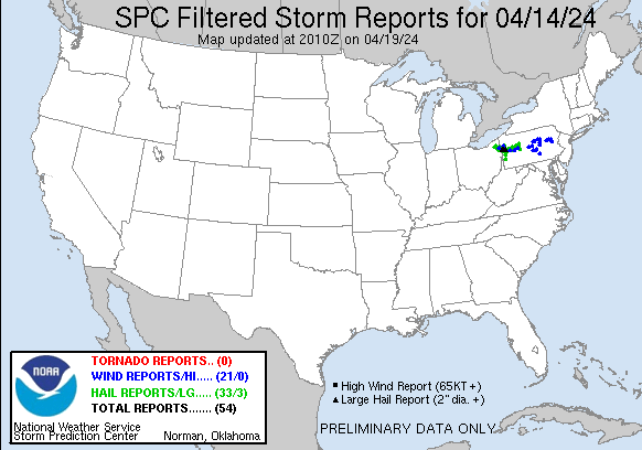
| Tornado Reports (CSV) (Raw Tornado CSV)(?) |
|---|
| No reports received |
| Hail Reports (CSV) (Raw Hail CSV)(?) |
|---|
Time | Size | Location | County | State | Lat | Lon | Comments |
| 2114 | 100 | 3 SW West Farmington | Geauga | OH | 4137 | 8102 | NWS employee reports hail of dime to quarter size just east of Parkman in SE Geauga County. (CLE) |
| 2115 | 200 | Volant | Lawrence | PA | 4111 | 8026 | (PBZ) |
| 2115 | 150 | Bristolville | Trumbull | OH | 4139 | 8087 | Social media report of hail up to ping pong ball in Bristolville. (CLE) |
| 2126 | 100 | 4 NNE Vienna | Trumbull | OH | 4131 | 8065 | 8 minutes of hail with some up to quarter-sized in Fowler Twp. (CLE) |
| 2128 | 100 | 1 SSW Cortland | Trumbull | OH | 4132 | 8073 | Trained spotter reported quarter sized hail near SR 5 and SR 46 near Cortland. (CLE) |
| 2130 | 100 | Jackson Center | Mercer | PA | 4127 | 8014 | (PBZ) |
| 2133 | 100 | 3 W Warren | Trumbull | OH | 4124 | 8087 | Trained spotter reported one inch hail west of Warren. (CLE) |
| 2133 | 100 | 3 E Cortland | Trumbull | OH | 4133 | 8067 | Hail for nearly 5 minutes is covering the ground. (CLE) |
| 2134 | 125 | 1 ESE Howland Center | Trumbull | OH | 4124 | 8072 | Social media photo shows hail up to half dollar size in Howland Township. (CLE) |
| 2134 | 175 | 2 W Warren | Trumbull | OH | 4125 | 8086 | Report from mPING: Golf Ball (1.75 in.). (CLE) |
| 2154 | 100 | Hubbard | Trumbull | OH | 4116 | 8057 | (CLE) |
| 2200 | 100 | Brockport | Elk | PA | 4127 | 7873 | W3MSB reports quarter-sized hail in Brockport. (CTP) |
| 2207 | 100 | New Wilmington | Lawrence | PA | 4112 | 8033 | (PBZ) |
| 2208 | 100 | Pulaski | Lawrence | PA | 4111 | 8043 | (PBZ) |
| 2210 | 175 | 1 S New Wilmington | Lawrence | PA | 4111 | 8033 | (PBZ) |
| 2210 | 175 | New Wilmington | Lawrence | PA | 4112 | 8033 | (PBZ) |
| 2211 | 100 | New Wilmington | Lawrence | PA | 4112 | 8033 | (PBZ) |
| 2215 | 175 | Volant | Lawrence | PA | 4111 | 8026 | (PBZ) |
| 2215 | 200 | New Wilmington | Lawrence | PA | 4112 | 8033 | (PBZ) |
| 2220 | 100 | 2 S Brent | Lawrence | PA | 4109 | 8017 | Hail reported along Old Ash Rd (PBZ) |
| 2221 | 100 | 1 WNW Plain Grove | Lawrence | PA | 4106 | 8016 | Hail reported along Georgetown Rd (PBZ) |
| 2225 | 175 | Slippery Rock | Butler | PA | 4107 | 8006 | (PBZ) |
| 2232 | 200 | Slippery Rock Park | Butler | PA | 4103 | 8002 | Hail reported along Rte 173 larger than a golf ball (PBZ) |
| 2232 | 175 | Slippery Rock | Butler | PA | 4107 | 8006 | (PBZ) |
| 2236 | 100 | 2 W West Liberty | Butler | PA | 4101 | 8009 | (PBZ) |
| 2237 | 125 | 1 S West Sunbury | Butler | PA | 4099 | 7990 | (PBZ) |
| 2237 | 150 | West Sunbury | Butler | PA | 4101 | 7990 | (PBZ) |
| 2245 | 100 | Karns City | Butler | PA | 4100 | 7973 | (PBZ) |
| 2247 | 100 | Karns City | Butler | PA | 4099 | 7973 | (PBZ) |
| 2253 | 100 | Mahaffey | Clearfield | PA | 4087 | 7872 | Report from mPING: Quarter (1.00 in.). (CTP) |
| 2254 | 100 | 3 N Worthington | Armstrong | PA | 4088 | 7963 | (PBZ) |
| 2313 | 100 | SE Slippery Rock | Butler | PA | 4106 | 8004 | (PBZ) |
| 2314 | 100 | Rimersburg | Clarion | PA | 4104 | 7950 | (PBZ) |
| 2321 | 150 | Poland | Mahoning | OH | 4102 | 8061 | Social media report of hail up to 1.5 inches in Poland. (CLE) |
| 2335 | 150 | 3 SSE South New Castle | Lawrence | PA | 4093 | 8032 | (PBZ) |
| 2335 | 100 | Pulaski | Lawrence | PA | 4111 | 8043 | so far the fifth storm of the evening. (PBZ) |
| 2337 | 100 | Karns City | Butler | PA | 4100 | 7973 | (PBZ) |
| 2340 | 125 | 6 S Clarion | Clarion | PA | 4113 | 7936 | (PBZ) |
| 2341 | 100 | 3 N New Castle | Lawrence | PA | 4104 | 8035 | (PBZ) |
| 2341 | 125 | New Wilmington | Lawrence | PA | 4112 | 8033 | (PBZ) |
| 2342 | 100 | East Brady | Clarion | PA | 4098 | 7961 | (PBZ) |
| 2342 | 100 | 5 S New Wilmington | Lawrence | PA | 4103 | 8033 | (PBZ) |
| 2352 | 100 | New Castle | Lawrence | PA | 4100 | 8035 | (PBZ) |
| 2352 | 125 | New Castle | Lawrence | PA | 4103 | 8034 | (PBZ) |
| 2353 | 150 | New Castle | Lawrence | PA | 4100 | 8035 | (PBZ) |
| 2353 | 100 | 5 N New Castle | Lawrence | PA | 4107 | 8035 | (PBZ) |
| 2354 | 125 | 6 S Clarion | Clarion | PA | 4112 | 7938 | (PBZ) |
| 2357 | 100 | Brookville | Jefferson | PA | 4116 | 7908 | (PBZ) |
| 0000 | 100 | 2 NW Boardman | Mahoning | OH | 4106 | 8069 | Mostly dime to nickel sized ... some as large as quarter sized. (CLE) |
| 0005 | 100 | Portersville | Butler | PA | 4093 | 8014 | (PBZ) |
| 0008 | 100 | Pulaski | Lawrence | PA | 4111 | 8043 | (PBZ) |
| 0038 | 100 | North Washington | Butler | PA | 4105 | 7981 | (PBZ) |
| 0040 | 100 | Sykesville | Jefferson | PA | 4105 | 7882 | (PBZ) |
| 0053 | 100 | Fairmont City | Clarion | PA | 4101 | 7931 | (PBZ) |
| 0100 | 125 | Mount Chestnut | Butler | PA | 4089 | 7998 | (PBZ) |
| 0103 | 175 | Greenwood Village | Butler | PA | 4088 | 7996 | (PBZ) |
| 0104 | 100 | 1 N Harmony Junction | Butler | PA | 4081 | 8011 | (PBZ) |
| 0110 | 125 | Mount Chestnut | Butler | PA | 4089 | 7998 | (PBZ) |
| 0113 | 100 | Lyndora | Butler | PA | 4085 | 7993 | (PBZ) |
| 0114 | 100 | 2 W Butler | Butler | PA | 4087 | 7995 | (PBZ) |
| 0115 | 100 | 2 W Butler | Butler | PA | 4086 | 7993 | Retired NWS Employee (PBZ) |
| 0116 | 100 | Butler | Butler | PA | 4086 | 7990 | (PBZ) |
| 0116 | 100 | 1 S Shanor Heights | Butler | PA | 4088 | 7991 | (PBZ) |
| 0133 | 100 | 1 E Templeton | Armstrong | PA | 4091 | 7944 | Reported a few bigger stones and a large amount of smaller hail (PBZ) |
| 0148 | 100 | 1 SSW Lovi | Beaver | PA | 4066 | 8016 | (PBZ) |
| 0416 | 100 | Oakdale | Allegheny | PA | 4040 | 8019 | (PBZ) |
| 0417 | 100 | 1 SE Oakdale | Allegheny | PA | 4039 | 8017 | (PBZ) |
| 0421 | 100 | Upper St. Clair | Allegheny | PA | 4034 | 8008 | (PBZ) |
| Wind Reports (CSV) (Raw Wind CSV)(?) |
|---|
Time | Speed | Location | County | State | Lat | Lon | Comments |
| 2118 | UNK | 2 W Stoneboro | Mercer | PA | 4133 | 8014 | Two 80 ft Pine trees down. (PBZ) |
| 2135 | 68 | Youngstown-Warren Regio | Trumbull | OH | 4125 | 8067 | ASOS station KYNG Youngstown measured a 59 kt thunderstorm wind gust. (CLE) |
| 2240 | UNK | Big Run | Jefferson | PA | 4097 | 7888 | power lines down (PBZ) |
| 2244 | UNK | Mcelhattan, PA | Clinton | PA | 4117 | 7737 | Multiple Trees down in the center of the small town. (CTP) |
| 2245 | UNK | 2 WNW Montoursville | Lycoming | PA | 4126 | 7696 | Large tree knocked over that took wires down with it. Also had a large limb fall. (CTP) |
| 2250 | UNK | Dayton | Armstrong | PA | 4088 | 7924 | Tree reported on roadway (PBZ) |
| 2255 | UNK | 5 N Worthington | Armstrong | PA | 4091 | 7963 | Trees reported on roadway. (PBZ) |
| 2258 | UNK | 4 ESE Zion | Centre | PA | 4089 | 7760 | Pole and Trees down - wires down. (CTP) |
| 2301 | UNK | Howard | Centre | PA | 4101 | 7766 | 900 block of Walnut Str. Tree down on electrical wires. (CTP) |
| 2319 | UNK | Nescopeck | Luzerne | PA | 4105 | 7621 | Multiple reports of trees and wires down. (BGM) |
| 2322 | 59 | Selinsgrove | Snyder | PA | 4081 | 7687 | Wind Gust reported via METAR. (CTP) |
| 2326 | UNK | 1 NW Conyngham | Luzerne | PA | 4100 | 7607 | Multiple reports of trees and wires down in Sugarloaf area. (BGM) |
| 2333 | UNK | 3 NNE Drums | Luzerne | PA | 4105 | 7597 | Multiple reports of trees and wires down in Butler Township. (BGM) |
| 2333 | UNK | Avis | Clinton | PA | 4119 | 7732 | Report from Clinton County EM - Roof blown off of building. (CTP) |
| 2335 | UNK | 3 NNE Park Forest | Centre | PA | 4083 | 7788 | Trees down across the road on Fox Hill Road near the turn on the corner to the Airport. (CTP) |
| 2335 | UNK | East Side | Carbon | PA | 4106 | 7577 | Report of trees down on State Route 940. Time estimated from radar. (PHI) |
| 2348 | UNK | Milton | Northumberland | PA | 4101 | 7685 | Multiple trees down across various streets and roads in the Lewisburg-Milton areas. ID 152109. (CTP) |
| 2349 | UNK | 1 SSW Jim Thorpe | Carbon | PA | 4086 | 7574 | Reports of trees down at the intersection of Hill Road and West Broadway in Jim Thorpe. Time estimated from radar. (PHI) |
| 0000 | UNK | Mifflintown | Juniata | PA | 4057 | 7740 | 322 Eastbound near Mexico ... PA and Mifflintown ... PA Multiple signs blown down across the roadway impacting traffic in the high winds. (CTP) |
| 0015 | UNK | 1 W Thompsontown | Juniata | PA | 4057 | 7725 | Tree down blocking lanes of Rte 322. (CTP) |
| 0024 | UNK | Hughesville | Lycoming | PA | 4124 | 7673 | 3-inch tree limbs broken; Power poles broken. (CTP) |
| 0025 | UNK | Mechanicsburg | Cumberland | PA | 4021 | 7701 | Large tree down blocking the roadway of University Ave. (CTP) |
| 0027 | UNK | 2 SSE Carlisle Springs | Cumberland | PA | 4022 | 7717 | Reports of trees and wires down in Carlisle and vicinity. (CTP) |
| 0040 | UNK | 1 SE Lewistown | Mifflin | PA | 4059 | 7756 | Roof damage to the shingles on a house roof. (CTP) |


 @NWSSPC