(All days are valid from 12 UTC - 12 UTC the following day)
Note: A severe weather area depicted in the Day 4-8 period indicates 15%, 30% or higher probability for severe thunderstorms within 25 miles of any point.
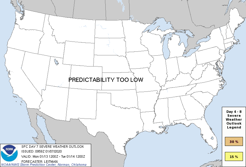
PREDICTABILITY TOO LOW is used to indicate severe storms may be possible based on some model scenarios. However, the location or occurrence of severe storms are in doubt due to: 1) large differences in the deterministic model solutions, 2) large spread in the ensemble guidance, and/or 3) minimal run-to-run continuity.
POTENTIAL TOO LOW means the threat for a regional area of organized severe storms appears unlikely (i.e., less than 15%) for the forecast day.
Forecast Discussion
ZCZC SPCSWOD48 ALL
ACUS48 KWNS 070959
SPC AC 070959
Day 4-8 Convective Outlook
NWS Storm Prediction Center Norman OK
0359 AM CST Tue Jan 07 2020
Valid 101200Z - 151200Z
...DISCUSSION...
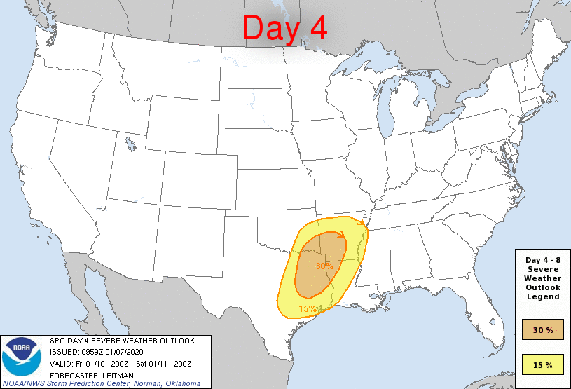
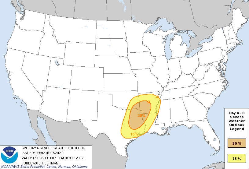
A multi-day severe weather episode is expected Day 4-5/Fri-Sat from
the Arklatex into the Deep South vicinity. An intense mid/upper
trough over the Four Corners and northwest Mexico early on Friday
will eject eastward into the southern Plains by 12z Saturday. At the
surface, low pressure will develop over TX and shift east/northeast
toward central AR by 12z Saturday. Ahead of the low, rich Gulf
moisture will stream northward across eastern TX/OK and expand
eastward across the lower MS Valley and Gulf Coast states through
Saturday. 60s F dewpoints are forecast to extend as far north as the
lower OH Valley by Saturday morning, with upper 60s to near 70s
dewpoints over parts of the Arklatex on Friday into much of
LA/MS/AL/GA on Saturday. This anomalously rich and broad warm sector
will reside beneath a 50-70 kt southerly low level jet and 80+ kt
southwesterly 500 mb jet streak. While some questions remain over
how pristine the warm sector ahead of the surface low and cold front
will remain, especially on Saturday, this kinematic and
thermodynamic parameter-space will support severe thunderstorms
capable of all severe hazards from the Arklatex into the TN
Valley/Gulf Coast states Friday and Saturday. Mixed convective modes
are anticipated given the strength of shear, with a QLCS likely
developing ahead of the surface cold front. This will support
damaging gusts and mesovortex tornado potential. Additionally, any
semi-discrete convection that develops ahead of the QLCS will be in
an environment capable of supporting supercells and tornadoes,
especially from east TX through central MS/AL.
Beyond Saturday, a reprieve from severe potential is expected on Day
6/Sun as high pressure builds over the east and the surface cold
front stalls near the southeast Atlantic coast and northern Gulf
coast. However, some severe potential could return early next week
as a mean trough is forecast to persist across the western half of
the country while shortwave impulses eject east/northeast from the
southern Plains through the Midwest on Day 7-8/Mon-Tue. Confidence
in how much the airmass will be able to recover and destabilize
remains in question, as the southeastern U.S. is forecast to receive
quite a bit of rain. As such, confidence is too low to include
severe probs at this time.
..Leitman.. 01/07/2020
CLICK TO GET WUUS48 PTSD48 PRODUCT


 @NWSSPC