(All days are valid from 12 UTC - 12 UTC the following day)
Note: A severe weather area depicted in the Day 4-8 period indicates 15%, 30% or higher probability for severe thunderstorms within 25 miles of any point.
PREDICTABILITY TOO LOW is used to indicate severe storms may be possible based on some model scenarios. However, the location or occurrence of severe storms are in doubt due to: 1) large differences in the deterministic model solutions, 2) large spread in the ensemble guidance, and/or 3) minimal run-to-run continuity.
POTENTIAL TOO LOW means the threat for a regional area of organized severe storms appears unlikely (i.e., less than 15%) for the forecast day.
Forecast Discussion
ZCZC SPCSWOD48 ALL
ACUS48 KWNS 190854
SPC AC 190854
Day 4-8 Convective Outlook
NWS Storm Prediction Center Norman OK
0354 AM CDT Sun Apr 19 2020
Valid 221200Z - 271200Z
...DISCUSSION...
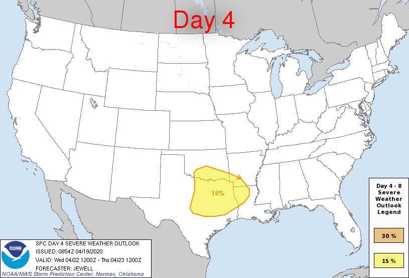
On Wednesday/D4, a positive-tilt shortwave trough will move east
across the southern Plains during the day, and toward the lower MS
Valley overnight. A surface low is forecast to travel east roughly
along the Red River with a cold front near I-35 in OK/TX by 00Z.
Models indicate mid 60s F dewpoints as far north as the Red River,
with upper 60s F to Dallas. Given cool temperatures aloft, this will
likely result in a minimum of 1500 J/kg MUCAPE ahead of the cold
front, with some models such as the ECMWF indicating over 2500 J/kg.
Ample lift should result in numerous storms over TX and OK by late
afternoon. Supercells producing large hail and perhaps a few
tornadoes will be possible given strong deep-layer shear and 200-300
m2/s2 ESRH. Farther east toward the lower MS Valley, warm advection
will be strong, resulting in numerous storms. It is questionable how
much SBCAPE will be present in this region, but the southern fringe
of the warm advection activity may remain severe across southern AR
and northern LA.
By Thursday/D5, models generally agree with the upper pattern
showing the positive-tilt upper trough over the Southeast. However,
there are significant differences in terms of warm-sector quality,
mainly due to storm coverage. For example, the ECMWF shows
widespread rain and storms over MS early, spreading east and
minimizing instability over much of MS, AL, and GA. Given these
uncertainties, will wait until predictability increases before
introducing a possible risk area for the Southeast on D5.
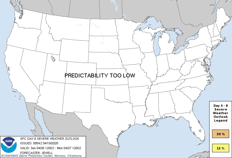
For the Friday/D6 to Sunday/D8 period, potential for severe storms
will persist, as models show potential for another upper trough to
develop over the southern Plains Friday, and intensifying over the
Southeast through Sunday/D8. However, there is significant model
disagreement, and predictability is much too low to place a risk
area.
..Jewell.. 04/19/2020
CLICK TO GET WUUS48 PTSD48 PRODUCT


 @NWSSPC