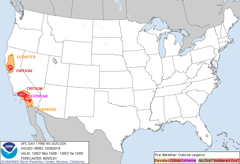
Storm Prediction Center Day 1 Fire Weather Outlook
Created: Mon Oct 28 06:57:03 UTC 2019 (
![]() |
| ![]() )
)
|
Click for Day 1 FireWX Areal Outline Product
   ZCZC SPCFWDDY1 ALL
   FNUS21 KWNS 280656

   Day 1 Fire Weather Outlook
   NWS Storm Prediction Center Norman OK
   0156 AM CDT Mon Oct 28 2019

   Valid 281200Z - 291200Z

   ...EXTREMELY CRITICAL FIRE WEATHER AREA FOR PORTIONS OF LOS
   ANGELES...VENTURA...AND SAN BERNADINO COUNTIES....
   ...CRITICAL FIRE WEATHER AREA FOR PORTIONS OF THE TRANSVERSE AND
   PENINSULAR RANGES IN SOUTHERN CALIFORNIA...
   ...CRITICAL FIRE WEATHER AREA FOR PORTIONS OF THE NORTHERN BAY
   AREA...

   ...Synopsis...
   High pressure will strengthen over the Great Basin early this
   morning as a very cold airmass settles into the region. This will
   maintain a strong offshore pressure gradient across northern
   California into the first half of the day today. By the afternoon
   and evening, the pressure gradient should relax enough to alleviate
   most critical fire weather concerns.

   ...Northern California...
   At the beginning of the period, critical winds and relative humidity
   are expected to be ongoing in the higher terrain of the northern Bay
   Area with lighter winds in the valleys and lower terrain. These
   conditions are expected to last through the morning before quickly
   weakening toward mid-day as the pressure gradient relaxes due to
   daytime heating in the Great Basin. Once winds weaken, they should
   remain weak until early Tuesday morning when northerly winds start
   to strengthen again in the Sacramento Valley after 06Z.

   ...Southern California...
   Extremely critical fire weather conditions are expected to be
   ongoing at the beginning of the period across portions of Los
   Angeles, Ventura, and San Bernadino counties. Current 06Z
   observations show around half a dozen sites reporting 30+ mph
   sustained winds. Relative humidity is currently in the 15 to 20
   percent range, but is expected to drop significantly as downslope
   flow continues. The worst conditions are expected this morning as
   the gradient peaks near 8-9mb around 14Z. In addition, relative
   humidity is expected to be 5 to 10 percent during this time.
   Conditions are expected to improve by mid-late afternoon as the
   pressure gradient relaxes and winds weaken.

   ..Bentley.. 10/28/2019

   ...Please see www.spc.noaa.gov/fire for graphic product...