Storm Prediction Center Day 1 Fire Weather Outlook
Created: Thu Oct 31 05:05:02 UTC 2019 (
![]() |
| ![]() )
)
|
Click for Day 1 FireWX Areal Outline Product
ZCZC SPCFWDDY1 ALL
FNUS21 KWNS 310503
Day 1 Fire Weather Outlook
NWS Storm Prediction Center Norman OK
1203 AM CDT Thu Oct 31 2019
Valid 311200Z - 011200Z
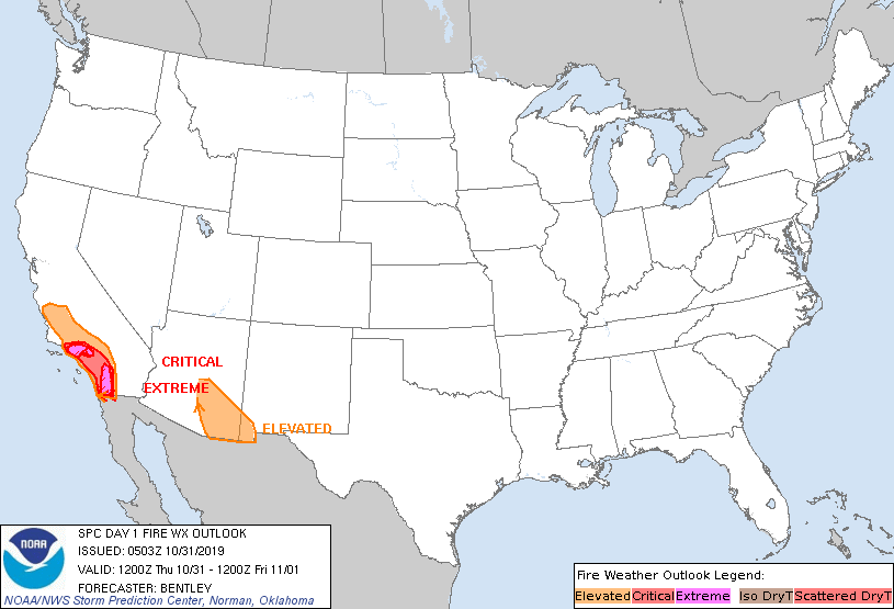
...EXTREMELY CRITICAL FIRE WEATHER AREA FOR THE LOS ANGELES AND
VENTURA COUNTY MOUNTAINS...
...EXTREMELY CRITICAL FIRE WEATHER AREA FOR THE RIVERSIDE AND SAN
DIEGO COUNTY MOUNTAINS...
...CRITICAL FIRE WEATHER AREA FOR THE PENINSULAR AND TRANSVERSE
RANGES IN SOUTHERN CALIFORNIA...
...Synopsis...
A strong surface high pressure centered over the Central Rockies
will lead to a strong offshore pressure gradient across southern
California to start the period. This will lead to extremely critical
fire weather conditions for at least the morning hours today before
winds weaken during the afternoon.
...Southern California...
Current 05Z observations show around 20 observation sites in
southern California with extremely critical fire weather conditions
(30 to 40 mph sustained winds and RH around 5 to 8 percent) ongoing.
The LAX-DAG pressure gradient is 7.1 mb with strengthening of 1 to 2
mb expected this morning as the Great Basin radiates and high
pressure increases. Considering ongoing widespread extremely
critical conditions, further drying downslope flow across the
region, and a slight tightening of the gradient, expect extremely
critical fire weather conditions to persist through at least the
morning hours. Daytime heating across the Central Rockies and Great
Basin will lead to significant lowering of the surface pressure
which should slacken the gradient and bring lighter winds during the
afternoon hours. Winds may weaken to around 10 to 15 mph, but some
strengthening is expected again tonight due to a combination of
another very cold night in the Great Basin and a reinforcing area of
high pressure moving out of Canada. Winds may increase to near
critical strength again tonight, but the strongest winds will likely
be confined to the highest peaks.
...Southeast Arizona and Far Southwest New Mexico...
The same pressure gradient which will be causing the strong offshore
flow in southern California will also cause some stronger winds in
southeast Arizona and far southwest New Mexico. Winds are expected
to be 15 to 20 mph with relative humidity in the 12 to 18 percent
range. The peak wind speeds are expected during the afternoon during
the strongest mixing.
..Bentley.. 10/31/2019
...Please see www.spc.noaa.gov/fire for graphic product...