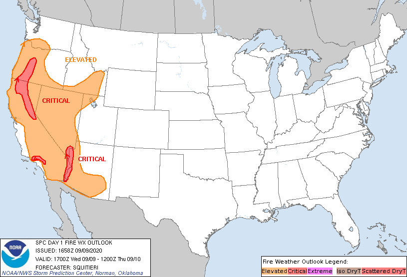
Storm Prediction Center Day 1 Fire Weather Outlook
Created: Wed Sep 9 17:00:07 UTC 2020 (
![]() |
| ![]() )
)
|
Click for Day 1 FireWX Areal Outline Product
   ZCZC SPCFWDDY1 ALL
   FNUS21 KWNS 091658

   Day 1 Fire Weather Outlook
   NWS Storm Prediction Center Norman OK
   1158 AM CDT Wed Sep 09 2020

   Valid 091700Z - 101200Z

   ...CRITICAL FIRE WEATHER AREA FOR PARTS OF OREGON AND CALIFORNIA
   ALONG THE WESTERN SLOPES OF THE CASCADES AND SIERRA...
   ...CRITICAL FIRE WEATHER AREA FOR PARTS OF SOUTHERN CALIFORNIA ALONG
   THE TRANSVERSE RANGES...
   ...CRITICAL FIRE WEATHER AREA FOR PARTS OF THE LOWER COLORADO RIVER
   VALLEY...ALONG THE CALIFORNIA...ARIZONA...NEVADA BORDER...

   Portions of the southernmost Transverse Ranges in southern
   California were removed from the Critical delineation. Some of the
   latest METAR observations depict calming winds from the San
   Bernardino Mountains southward, with high-resolution guidance
   depicting subsiding winds into the afternoon. Clear skies (noted via
   visible satellite) and resultant diurnal heating are contributing to
   vigorous boundary-layer mixing across portions of the lower Colorado
   River Valley. Latest METAR observations depict solidly critical
   conditions ongoing, with 15-20% RH coinciding with 20-30 mph
   sustained northerly winds. As such, no changes have been made to
   this critical area. The critical area for the western slopes of the
   Sierra/Cascades in California/Oregon has been maintained, as gusty
   easterly winds may persist to the west of the higher terrain for at
   least a couple more hours. Otherwise, Elevated criteria winds/RH may
   occur across much of the western Great Basin westward with continued
   boundary-layer-mixing, with no changes to the Elevated area made.

   ..Squitieri.. 09/09/2020

   .PREV DISCUSSION... /ISSUED 0151 AM CDT Wed Sep 09 2020/

   ...Synopsis...
   The strong offshore pressure gradient resulting from central Rockies
   high pressure and West Coast low pressure will remain in place much
   of the forecast period, though a weakening trend will commence late
   in the day as the high weakens and shifts eastward toward the
   central Plains.  Meanwhile, subsidence aloft on the west side of a
   cutoff low over the Four Corners area will continue to maintain a
   very hot, dry airmass across much of the western states.  The
   overall pattern will maintain widespread elevated fire-weather
   conditions along with a few areas of critical fire weather near
   terrain-favored areas.

   ...Western Oregon into northern and central California...
   Areas of critical fire-weather are likely to be ongoing at the
   beginning of the forecast period amidst areas of poor recovery and
   localized terrain-related forcing providing impetus for 20-30 mph
   surface winds.  The winds are likely to be strongest along the
   Cascades and Sierras, where critical delineations remain in place.
   Morning RH values in the 10-15% range will fall into the single
   digits during the day in response to insolation and surface
   temperatures rising into the low 90s F.  These conditions, along
   with near-record ERCs, will continue to exacerbate significant
   issues with large ongoing fires exhibiting extreme behavior and
   spotting.  At this time, it appears that surface winds will begin to
   weaken through the evening in response to a weakening surface
   pressure gradient, which should limit critical fire-weather
   conditions to localized areas of gusty winds - especially overnight.


   ...Coastal Ranges of southern California...
   The aforementioned surface pressure gradient will encourage areas of
   gusty winds (35-45 mph) in terrain-favored areas through mid-day.
   These gusts will occur within a very dry airmass exhibiting poor
   recovery, with 10-20% RH values falling into the 5-15% range as
   insolation/surface warming commences.  These conditions will combine
   with dry fuels across the region to support continued, critical fire
   weather.  Again, surface winds should weaken from mid-day onward as
   the surface pressure gradient diminishes and winds weaken.

   ...Lower Colorado River Valley...
   Latest model guidance indicates a corridor of stronger surface winds
   (with gusts exceeding 40 mph) continuing from early morning through
   late evening amidst critically low RH values (around 15% in the
   morning, falling to around 7-9% through the afternoon).  The
   corridor of strongest surface winds will correspond with terrain
   along the Valley, where dry fuels beds will support rapid fire
   spread with any ignitions.  A critical fire-weather delineation has
   been introduced in this outlook to address the threat.

   ...Please see www.spc.noaa.gov/fire for graphic product...