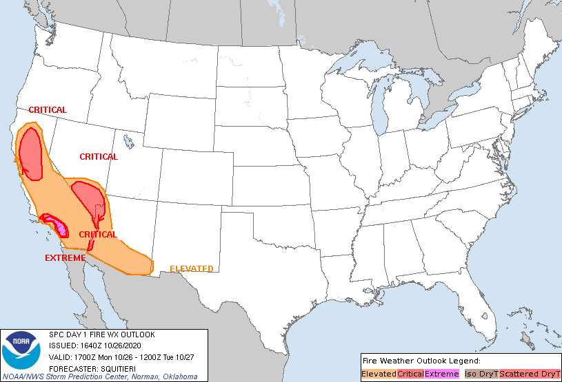
Storm Prediction Center Day 1 Fire Weather Outlook
Created: Mon Oct 26 16:41:03 UTC 2020 (
![]() |
| ![]() )
)
|
Click for Day 1 FireWX Areal Outline Product
   ZCZC SPCFWDDY1 ALL
   FNUS21 KWNS 261640

   Day 1 Fire Weather Outlook
   NWS Storm Prediction Center Norman OK
   1140 AM CDT Mon Oct 26 2020

   Valid 261700Z - 271200Z

   ...EXTREMELY CRITICAL FIRE WEATHER AREA FOR PORTIONS OF THE SOUTHERN
   TRANSVERSE RANGES IN SOUTHERN CALIFORNIA...
   ...CRITICAL FIRE WEATHER AREA FOR PARTS OF SOUTHERN CALIFORNIA...
   ...CRITICAL FIRE WEATHER AREA FOR PORTIONS OF NORTHERN AND CENTRAL
   CALIFORNIA...
   ...CRITICAL FIRE WEATHER AREA FOR PARTS OF SOUTHERN NEVADA INTO THE
   COLORADO RIVER BASIN...

   Current visible satellite depicts clear skies across California and
   the Great Basin, allowing for ample boundary-layer heating and
   continued mixing. As such, near-critical to critically low RH is
   expected to persist across much of California into the southern
   Great Basin through the day. Current METAR observations depict 20-30
   mph sustained winds, with higher gusts from the Sacramento Valley in
   northern California, down to the southern Transverse Ranges in
   southern California and eastward into the Colorado River Basin. In
   addition, 60-80 kt mid-level flow continues to overspread California
   into Nevada. Upper support, downslope flow, and downward momentum
   transport of the stronger mid-level flow will continue to foster
   strong northerly/offshore flow across portions of the Sacramento/San
   Joaquin Valleys and the southern Transverse Ranges in California
   through the day, as also suggested by the latest model guidance
   consensus. Critical/Extremely Critical Highlights have been
   maintained across California, although widespread Extremely Critical
   conditions in the southern Transverse ranges may gradually subside
   by late afternoon. Critical conditions however, are still expected
   to persist across southern California into tomorrow morning.

   At the moment, temperatures are rather cool across parts of southern
   Nevada, with temperatures in the upper 30s to mid 40s. However,
   temperatures are expected to warm into the 50s by afternoon peak
   heating, that combined with continued 25-40 mph sustained northerly
   flow and 10-25% RH, will foster Critical wildfire-spread conditions
   through the afternoon.

   ..Squitieri.. 10/26/2020

   .PREV DISCUSSION... /ISSUED 0152 AM CDT Mon Oct 26 2020/

   ...Synopsis...
   A very steep pressure gradient will persist across dry areas of the
   West and Southwest today in response to 1) very strong high pressure
   over the western Great Basin and 2) surface troughing from the
   California coastline southeastward through Arizona and western New
   Mexico.  Additionally, very strong flow aloft will persist across
   these areas in response to a vigorous mid-level wave expected to be
   centered over Utah at 12Z and Arizona in the evening.  Continued dry
   fuels and areas of drought will continue to support higher-end
   fire-weather conditions particularly in portions of California.

   ...Southern California...
   Models/high resolution guidance continue to indicate very strong
   flow across typical, terrain-favored areas of the southern
   Transverse Ranges throughout the forecast period.  Northeasterly
   surface flow will range from 25-35 mph, with gusts perhaps as high
   as 70 mph in spots.  Meanwhile, very low RH will continue given the
   dry airmass in place, with 5-15% values becoming common during the
   day as surface heating commences.  Fuels remain dry and favorable
   for fire spread given continued dry conditions over the past several
   months.  Guidance suggests that these conditions will continue even
   into the evening hours, owing to poor overnight recoveries and the
   continued offshore gradient.

   ...Northern California and the Bay Area...
   Elevated to critical fire-weather conditions will likely be ongoing
   at the start of the period as current (05Z-06Z) observations
   indicate areas of 25-35 mph northerly low-level flow and 7-15% RH
   values, indicating very poor recovery.  The strong surface pressure
   gradient and favorable upper support suggest that these conditions
   will continue throughout the day, with RH values remaining low amid
   surface warming.  A few areas may experience gusts to 70 mph.  Fuels
   remain extremely dry/combustible, and a few areas will likely exceed
   extremely critical thresholds at times - especially in areas between
   Sacramento and San Francisco/Oakland and including the North Bay
   Mountains and East Bay Hills.

   ...Southern Nevada through the Lower Colorado River Valley...
   Recent high-resolution guidance indicates that enough surface
   warming will occur for temperatures to reach the 60s F during peak
   heating hours despite northerly surface flow and modest cold
   advection.  The residing airmass across the region is quite dry, and
   as temperatures increase, surface RH values will fall into the 5-15%
   range during the afternoon.  Additionally, surface winds will
   increase into the 25-35 mph range given the surface pressure
   gradient across the region.  Critical fire-weather delineations
   exist where the aforementioned conditions are most likely to occur
   amidst dry fuels/fuel beds.

   ...Please see www.spc.noaa.gov/fire for graphic product...