Storm Prediction Center Day 1 Fire Weather Outlook
Created: Wed Dec 15 07:35:03 UTC 2021 (
![]() |
| ![]() )
)
|
Click for Day 1 FireWX Areal Outline Product
ZCZC SPCFWDDY1 ALL
FNUS21 KWNS 150733
Day 1 Fire Weather Outlook
NWS Storm Prediction Center Norman OK
0133 AM CST Wed Dec 15 2021
Valid 151200Z - 161200Z
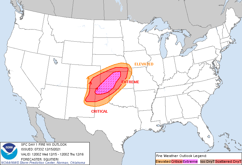
...EXTREMELY CRITICAL FIRE WEATHER AREA FOR PORTIONS OF THE NORTHERN
TEXAS PANHANDLE...THE OKLAHOMA PANHANDLE...AND MUCH OF WESTERN INTO
CENTRAL KANSAS...
...CRITICAL FIRE WEATHER AREA FOR PORTIONS OF NORTHEAST NEW
MEXICO...EASTERN COLORADO INTO FAR NORTHWEST OKLAHOMA...FAR SOUTHERN
NEBRASKA...AND MUCH OF KANSAS...
...Synopsis...
Very dangerous wildfire-spread conditions are still expected for
portions of the central Plains today. A 110 kt mid-level jet streak
accompanying a potent mid-level shortwave trough will traverse the
central Plains as an intense surface low quickly ejects into the
Upper Mississippi Valley this afternoon. An impressive vertical wind
profile will accompany the passing low, with widespread 60+ kt
low-level flow (just a few hundred feet above the ground) coinciding
with a mixing boundary layer. Gradient surface flow associated with
this intense low, combined with vertical mixing, will support very
windy and dry conditions atop critically dry fuels (90-98th
percentile ERCs) to support very rapid grassfire spread.
From late morning into mid afternoon, a few hours of widespread 35+
mph sustained west-southwesterly surface winds will overlap with
10-15 percent RH. Extremely Critical fire weather highlights remain
in place where confidence is highest in very windy/dry conditions
persisting longer than 3 hours, and where patchy areas of 40+ mph
sustained winds are more likely. East of the Extremely Critical
delineation, high-end Critical to locally Extremely Critical
conditions are likely.
..Squitieri.. 12/15/2021
...Please see www.spc.noaa.gov/fire for graphic product...