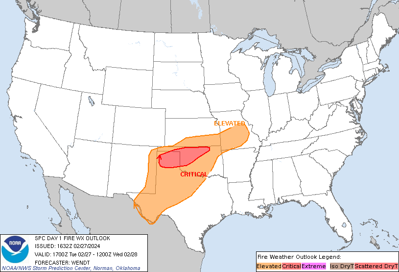
Storm Prediction Center Day 1 Fire Weather Outlook
Created: Tue Feb 27 16:34:03 UTC 2024 (
![]() |
| ![]() )
)
|
Click for Day 1 FireWX Areal Outline Product
   ZCZC SPCFWDDY1 ALL
   FNUS21 KWNS 271632

   Day 1 Fire Weather Outlook
   NWS Storm Prediction Center Norman OK
   1032 AM CST Tue Feb 27 2024

   Valid 271700Z - 281200Z

   ...CRITICAL FIRE WEATHER AREA FOR PORTIONS OF THE TEXAS PANHANDLE
   INTO NORTH-CENTRAL OKLAHOMA...

   Modest modifications have been made to the Elevated/Critical areas
   based on morning observations and the latest guidance. Ongoing fire
   activity in the Texas Panhandle will be exposed to increasing winds
   through the day. Furthermore, a wind shift to strong northerly winds
   will occur this evening in the southern Plains. See the previous
   discussion for additional details.

   ..Wendt.. 02/27/2024

   .PREV DISCUSSION... /ISSUED 0158 AM CST Tue Feb 27 2024/

   ...Synopsis...
   Split mid-level flow will gradually consolidate as a Pacific trough
   merges with an increasingly strong subtropical jet stream over the
   central CONUS. Very strong westerly flow is expected over the Plains
   and Midwest, supporting dry and windy conditions. Widespread
   elevated to critical fire-weather conditions are excepted.

   ...Southern Plains...
   As the upper trough begins to move over the Plains, strong low-level
   flow is expected to develop by mid morning. Westerly winds of 20-25
   mph, with gusts of 30-35 mph, are possible across parts of western
   and central OK and the TX Panhandle. Despite dry downsloping and the
   unusually warm temperatures, increasing mid and high-level cloud
   cover may limit diurnal RH minimums to near 20-25%. Still,
   widespread elevated to near/briefly critical fire-weather conditions
   appear likely given the increasingly strong wind gusts. Significant
   fire activity over the preceding days also suggests fuels are more
   receptive than some guidance indicated. Thus, greater confidence
   exists for critical conditions across parts of western and central
   OK and the eastern TX Panhandle where the strongest winds are
   expected to overlap more receptive fuels, despite marginal humidity.

   To the east, a pronounced low-level thermal ridge behind a surface
   trough will support afternoon RH values below 30% with southwest
   winds of 20-25 mph across the eastern Plains into western MO. While
   RH values are not overly dry, the strong winds and unusually warm
   temperatures should allow for widespread elevated to locally
   critical fire-weather conditions.

   Fire-weather concerns will begin to diminish later in the evening as
   a cold front rapidly moves south. Strong gusts may persist behind
   the front along with a rapid wind shift to north/northwesterly.
   Cooler temperatures and higher RH behind the front should quickly
   limit sustained fire-weather concerns through the overnight hours.

   ...Please see www.spc.noaa.gov/fire for graphic product...