|
| Mesoscale Discussion 271 |
|
< Previous MD Next MD >
|
|
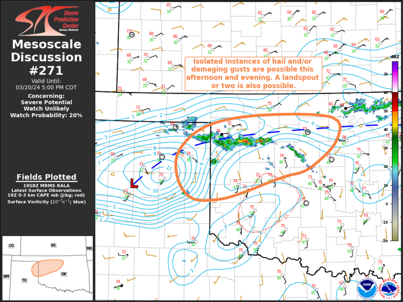
   Mesoscale Discussion 0271
   NWS Storm Prediction Center Norman OK
   0259 PM CDT Wed Mar 20 2024

   Areas affected...Eastern TX Panhandle into
   Northwestern/North-Central OK

   Concerning...Severe potential...Watch unlikely

   Valid 201959Z - 202200Z

   Probability of Watch Issuance...20 percent

   SUMMARY...Isolated instance of hail and/or damaging gusts are
   possible this afternoon and evening from the northeastern Texas
   Panhandle into northwest/north-central Oklahoma. A landspout or two
   is also possible.

   DISCUSSION...Recent surface analysis places a low over the the
   northwest TX (over the AMA to BPC vicinity). Leading edge of the
   cold front, indicated by weak surface troughing, extends
   east-northeastward from this low into northwest OK and then more
   eastward into north-central OK. Cumulus has been deepening along
   this boundary for the past few hours with thunderstorm initiation
   realized about 30 to 45 mins ago. Despite only modest buoyancy,
   these storms have steadily deepened, with echo tops now over 30kft.
   This general trend is expected to persist as convergence persists
   along the surface trough and the atmosphere continues to
   destabilize.

   Overall storm depth and severity will be mitigated by the limited
   buoyancy, but an isolated updraft or two may briefly by strong
   enough to produce hail. Steep low-level lapse rates and high storm
   bases also suggest the potential for damaging gusts as storms
   collapse. Lastly, given the sharp backing of the wind field near the
   surface trough, from southerly south of the boundary to
   northeasterly just north of it, notable surface vorticity is likely
   present along and just north of the boundary. Consequently, the
   environment supports the potential for a brief landspout or two.

   ..Mosier.. 03/20/2024

   ...Please see www.spc.noaa.gov for graphic product...

   ATTN...WFO...OUN...AMA...

   LAT...LON   35990067 36440009 36639894 36589739 36169732 35699789
               35569839 35449879 35289930 35169980 35170037 35490067
               35990067
|
|
Top/All Mesoscale Discussions/Forecast Products/Home
|
|


 @NWSSPC