|
| Mesoscale Discussion 135 |
|
< Previous MD Next MD >
|
|
Mesoscale Discussion 0135
NWS Storm Prediction Center Norman OK
0530 PM CDT Sun Mar 18 2018
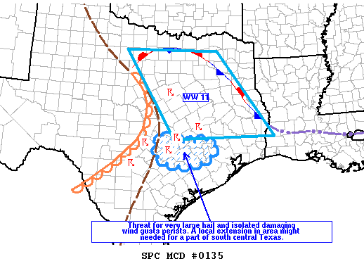
Areas affected...north central through south central and east Texas
Concerning...Severe Thunderstorm Watch 11...
Valid 182230Z - 190030Z
The severe weather threat for Severe Thunderstorm Watch 11
continues.
SUMMARY...Threat for isolated supercells capable of producing very
large hail and damaging wind gusts will continue into the evening
from a part of north central into south central and east Texas. WW
11 might need to be extended farther south or possibly a small new
watch east of San Antonio might be needed to account for potential
new development.
DISCUSSION...Early this evening isolated supercells that developed
along the dryline persist primarily from southern portion of north
central TX through south central TX. Visible imagery shows new high
based towers growing over south central TX within the more deeply
mixed regime along and just west of the dryline, as well as along a
confluence zone east of the dryline where the warm sector is
moderately unstable with steep lapse rates. A few of these new
updrafts might also evolve into mature supercells as they interact
with the strongly sheared and moderately unstable warm sector
(MLCAPE 2000 J/kg). Low level hodographs are not particularly large,
but strong effective bulk shear with unidirectional southwesterly
winds increasing to 60 kt through 8 km will support both right and
left movers.
..Dial.. 03/18/2018
...Please see www.spc.noaa.gov for graphic product...
ATTN...WFO...HGX...EWX...
LAT...LON 30479771 30259695 30299572 29749593 29529657 29539739
29829787 30479771
|
|
Top/All Mesoscale Discussions/Forecast Products/Home
|
|


 @NWSSPC