|
| Mesoscale Discussion 465 |
|
< Previous MD Next MD >
|

|
   Mesoscale Discussion 0465
   NWS Storm Prediction Center Norman OK
   0611 PM CDT Sat May 19 2018

   Areas affected...West and northwest TX...western and northern
   OK...southeast KS...and southwest MO

   Concerning...Severe Thunderstorm Watch 108...

   Valid 192311Z - 200115Z

   The severe weather threat for Severe Thunderstorm Watch 108
   continues.

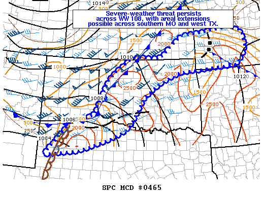
   SUMMARY...Local WFO extensions in area are possible across parts of
   south-central MO and in west TX.  Two areas of strong to severe
   storms persist across the southern part of WW 108 (in northwest TX
   to southwest OK) and northeast OK through southeast KS and southwest
   MO.  Large hail and damaging winds should be the primary threats in
   the short term, though a tornado cannot be ruled out in either of
   these portions of the watch.

   DISCUSSION......Northwest TX to south-central OK...
   Water vapor imagery showed a progressive shortwave trough moving
   through much of western TX late this afternoon.  Forcing for ascent
   with this trough is aiding in continued thunderstorm development
   near and north of a boundary extending from King County TX to
   Cochran County TX.  Storm mergers across Cottle and Childress
   counties TX appear to have formed into a cluster or attempts at
   being linear.  All of these storms in northwest TX are located
   within the strongest corridor of instability (MLCAPE 2000-2500 J/kg)
   and the southern extent of effective bulk shear favorable for
   supercells.  22Z mesoanalysis showed a boundary extending from
   Cottle and Foard counties TX into south-central OK (north of
   KSPS-KADM).  Given the current eastward movement of the
   Cottle/Childress counties cluster and new rapid storm development in
   Foard County TX, these storms should track to the east-northeast
   into far southwest to south-central OK this evening.

   ...West TX...
   Additional sustained updrafts per radar imagery were forming to the
   south-southwest between KLBB and KMAF in vicinity of the dryline.
   Trends in vertical wind profiles indicated backing of low-midlevel
   winds (surface to 700-mb winds) resulting in an increase of surface
   convergence along the dryline and providing some strengthening of
   effective bulk shear to support storm organization.  Therefore, the
   CAPE/shear parameter space is becoming more conducive to support
   sustained updrafts and subsequent sever storm threat.  Counties in
   WFO LUB area may need to be added to WW 108.

   ...Southwest to south-central MO...
   A forward propagating MCS moving east at 40 kt is posing a
   severe-weather threat for damaging winds across more of southern MO,
   resulting in an areal extension of WW 108.  This bow may begin to
   track to the east-southeast, near and north of a west-northwest to
   east-southeast oriented outflow boundary located across southern MO,
   where the strongest instability is located.

   ..Peters.. 05/19/2018

   ...Please see www.spc.noaa.gov for graphic product...

   ATTN...WFO...SGF...EAX...TSA...TOP...ICT...OUN...SJT...LUB...
   AMA...MAF...

   LAT...LON   32660267 34130137 34460018 36069946 36509895 37089812
               37059659 38049538 38209389 38329264 38129190 37319174
               36639230 36489475 36429554 35959661 35319752 34749783
               34209816 33859851 33469929 32910088 32660267
|
|
Top/All Mesoscale Discussions/Forecast Products/Home
|
|


