|
| Mesoscale Discussion 854 |
|
< Previous MD Next MD >
|
|
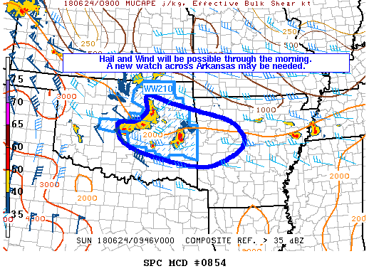
   Mesoscale Discussion 0854
   NWS Storm Prediction Center Norman OK
   0511 AM CDT Sun Jun 24 2018

   Areas affected...eastern Oklahoma and western Arkansas

   Concerning...Severe Thunderstorm Watch 210...

   Valid 241011Z - 241130Z

   CORRECTED FOR INCORRECT WATCH NUMBER REFERENCED IN GRAPHIC AND TEXT

   The severe weather threat for Severe Thunderstorm Watch 210
   continues.

   SUMMARY...Thunderstorms capable of large hail and gusty outflow
   winds will continue through the morning. As these storms move into
   western Arkansas, a new watch may be necessary.

   DISCUSSION...Long-lived bow echo continues to move across central
   and northeast Oklahoma along the 850-millibar theta-e gradient,
   which loosely corresponds to the most-unstable CAPE gradient. Given
   most-unstable CAPE values of 2000 J/kg and deep-layer shear on the
   order of 40 knots ahead of the parent mesoscale convective systems
   (MCS), and an even better CAPE reservoir to the southwest, all
   indications are that the ongoing MCS will exit WW210 later this
   morning.

   Additionally, warm-air advection thunderstorms across east-central
   and northeast Oklahoma continue to persist. Large hail and gusty
   winds remain possible with these storms. On their current
   trajectory, these storms will exit WW210 in the next 1-2 hours,
   which will likely require a new watch.

   ..Marsh/Guyer.. 06/24/2018

   ...Please see www.spc.noaa.gov for graphic product...

   ATTN...WFO...LZK...SHV...TSA...OUN...

   LAT...LON   35619755 35699689 36029644 36539644 36309553 36059442
               35729318 35149264 34679304 34329394 34359485 34659637
               35039733 35619755
|
|
Top/All Mesoscale Discussions/Forecast Products/Home
|
|


 @NWSSPC