|
| Mesoscale Discussion 1199 |
|
< Previous MD Next MD >
|
|
Mesoscale Discussion 1199
NWS Storm Prediction Center Norman OK
0623 PM CDT Sun Jul 29 2018
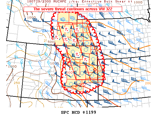
Areas affected...southeastern Wyoming...eastern Colorado...western
Nebraska...and far northwestern Kansas
Concerning...Tornado Watch 322...
Valid 292323Z - 300030Z
The severe weather threat for Tornado Watch 322 continues.
SUMMARY...The severe threat continues across WW 322.
DISCUSSION...Southeastward-moving thunderstorms continue to migrate
across WW 322 at this time. Favorable shear/buoyancy profiles have
supported occasional tornado and very large hail reports -
especially with a cluster of supercells migrating across
northeastern Colorado. Over the past hour or so, one dominant
high-precipitation supercell has evolved over Morgan and Washington
Counties and an expansive cold pool has spread northwest from this
storm across much of Weld County and vicinity. This may signal the
beginning of upscale growth advertised by the past several runs of
high-res models.
Upstream (in southeastern Wyoming), cellular storms may continue to
pose a threat for very large hail and a tornado or two given
favorable shear profiles and storm mode. Eventually, ongoing storms
will move top the remnant cold pool across northeastern Colorado,
which may lessen the overall tornado threat but still support large
hail in the strongest cores.
Farther south, convection near/west of Pueblo, CO has exhibited
brief supercellular characteristics and necessitated a spatial
expansion of the WW. Hail, damaging wind gusts, and tornadoes may
evolve from any dominant storm that can materialize in this region.
..Cook.. 07/29/2018
...Please see www.spc.noaa.gov for graphic product...
ATTN...WFO...LBF...DDC...UNR...GLD...PUB...BOU...CYS...RIW...
LAT...LON 43420632 43540561 43510433 43030318 41970228 40860186
39760147 38570158 38260164 38040218 37650308 37570419
37830505 38250538 38850533 39700513 40470542 41020617
41940652 42850659 43420632
|
|
Top/All Mesoscale Discussions/Forecast Products/Home
|
|


 @NWSSPC