|
| Mesoscale Discussion 1499 |
|
< Previous MD Next MD >
|
|
Mesoscale Discussion 1499
NWS Storm Prediction Center Norman OK
0339 PM CDT Tue Sep 25 2018
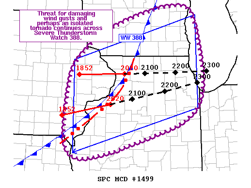
Areas affected...Eastern IA...Northern WI...Northern IL
Concerning...Severe Thunderstorm Watch 388...
Valid 252039Z - 252215Z
The severe weather threat for Severe Thunderstorm Watch 388
continues.
SUMMARY...Threat for damaging wind gusts and perhaps an isolated
tornado continues across the northern IL and southeast WI portions
of Severe Thunderstorm Watch 388.
DISCUSSION...Well-developed convective line moved across eastern IA
during the past hour and has recently moved into northwest IL.
Current storm motion is eastward at about 45 kt. Strong wind gusts
of 37 kt and 35 kt were measured at MLI and CWI, respectively. These
measurements and recent radar signatures from KDVN suggest the
strongest winds have not transferred to the surface thus far. The
downstream airmass across north-central and northeast IL appears a
bit more favorable for momentum transfer given the steeper low-level
lapse rates and deeper boundary-layer mixing. Tornadoes also remain
possible, although the veered low-level flow and largely
unidirectional wind profiles sampled by recent LOT and ILX VAD
profiles suggest the threat should remain isolated.
..Mosier.. 09/25/2018
...Please see www.spc.noaa.gov for graphic product...
ATTN...WFO...LOT...ILX...MKX...LSX...DVN...ARX...
LAT...LON 42579115 43219013 43668830 43268763 41358756 40568927
40179147 41829158 42579115
|
|
Top/All Mesoscale Discussions/Forecast Products/Home
|
|


 @NWSSPC