|
| Mesoscale Discussion 1516 |
|
< Previous MD Next MD >
|
|
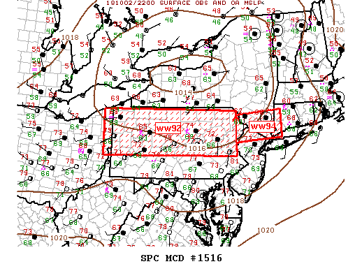
   Mesoscale Discussion 1516
   NWS Storm Prediction Center Norman OK
   0624 PM CDT Tue Oct 02 2018

   Areas affected...PA to Southwest CT

   Concerning...Tornado Watch 392...394...

   Valid 022324Z - 030045Z

   CORRECTED FOR WATCH TYPE

   The severe weather threat for Tornado Watch 392, 394 continues.

   SUMMARY...East-West band of strong/severe thunderstorms will sag
   southeast across central PA into northern NJ over the next few
   hours.

   DISCUSSION...Weak large-scale height falls are spreading across the
   northern Middle Atlantic ahead of a low-amplitude short-wave trough.
   Scattered supercells are noted along this corridor though multiple
   storm mergers are resulting in upward evolving east-west squall
   line. MRMS hail algorithm suggests a few supercells are generating
   hail near severe levels; otherwise, locally damaging winds remain
   possible with this activity. As supercell structures evolve into
   line segments and clusters, the threat of tornadoes should gradually
   decrease over the next few hours.

   ..Darrow.. 10/02/2018

   ...Please see www.spc.noaa.gov for graphic product...

   ATTN...WFO...OKX...ALY...PHI...BGM...CTP...PBZ...CLE...

   LAT...LON   41878084 41877519 41737520 41877326 40997325 40887486
               40867520 40417518 40398082 41878084
|
|
Top/All Mesoscale Discussions/Forecast Products/Home
|
|


 @NWSSPC