|
| Mesoscale Discussion 148 |
|
< Previous MD Next MD >
|
|
Mesoscale Discussion 0148
NWS Storm Prediction Center Norman OK
0219 PM CST Sun Mar 03 2019
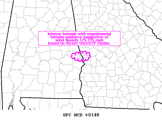
Areas affected...far east-central AL and far western GA
Concerning...Tornado Watch 7...8...
Valid 032019Z - 032045Z
The severe weather threat for Tornado Watch 7, 8 continues.
SUMMARY...An intense tornado with experimental tornado guidance
suggestive of wind speeds 125-175 mph based on recent volume scans
of rotational velocity and the significant tornado parameter.
DISCUSSION...A very intense supercell tornado will continue to move
through a very favorable environment. Confidence is high for a
significant tornado based on rotational velocity continuity, the
favorable mesoscale environment, and a relatively unimpeded warm
sector along the warm front.
..Smith.. 03/03/2019
...Please see www.spc.noaa.gov for graphic product...
ATTN...WFO...FFC...BMX...
LAT...LON 32578547 32678497 32578465 32438486 32438524 32578547
|
|
Top/All Mesoscale Discussions/Forecast Products/Home
|
|


 @NWSSPC