|
| Mesoscale Discussion 698 |
|
< Previous MD Next MD >
|
|
Mesoscale Discussion 0698
NWS Storm Prediction Center Norman OK
1041 AM CDT Mon May 20 2019
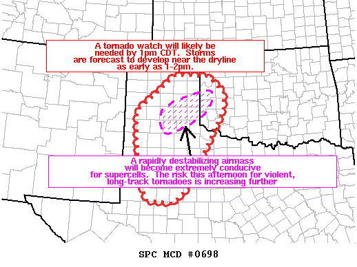
Areas affected...portions of northwest TX...TX Panhandle...and
western OK
Concerning...Severe potential...Tornado Watch likely
Valid 201541Z - 201815Z
Probability of Watch Issuance...95 percent
SUMMARY...A tornado watch will likely be needed by 1pm CDT. Storm
initiation is expected as early as 1-2pm along the dryline.
DISCUSSION...Visible satellite imagery shows the initial stages of a
bubbling cumulus field across the Texas South Plains from near
Midland northward to Lubbock. Late morning surface observations
show south-southeasterlies with rapid moisture advection occurring
with dewpoints rising to near 70 degrees F near the Low Rolling
Plains. Despite the scattered low cloud cover, additional heating
and moistening will contribute to extreme buoyancy (4000-5000 J/kg
MLCAPE) developing by early-mid afternoon east of a sharping dryline
in parts of northwest and west TX. The aforementioned theta-e
increase and weak large-scale forcing will likely lead to storms
explosively developing during the 1pm-3pm period.
Strong and veering low-level winds beneath very strong deep-layer
wind fields will likely result in sickle-shaped hodographs over the
TX Panhandle and western OK this afternoon. 0-1km SRH around 250
m2/s2 coupled with the extreme buoyancy will favor long-track and
potentially violent tornadoes with the strongest storms. Giant hail
(3-4+ inches in diameter) will be possible.
Farther south, tornadoes and very large hail are possible with any
supercells that develop near the Permian Basin.
..Smith/Hart.. 05/20/2019
...Please see www.spc.noaa.gov for graphic product...
ATTN...WFO...OUN...SJT...LUB...AMA...MAF...
LAT...LON 32130203 32900240 35010253 36220098 36199971 35699906
35089909 32510052 32060109 32130203
|
|
Top/All Mesoscale Discussions/Forecast Products/Home
|
|


 @NWSSPC