Mesoscale Discussion 0707
NWS Storm Prediction Center Norman OK
0435 PM CDT Mon May 20 2019
Areas affected...eastern Oklahoma...southeast Kansas...southwest
Missouri...and Arkansas
Concerning...Severe potential...Watch likely
Valid 202135Z - 202330Z
Probability of Watch Issuance...80 percent
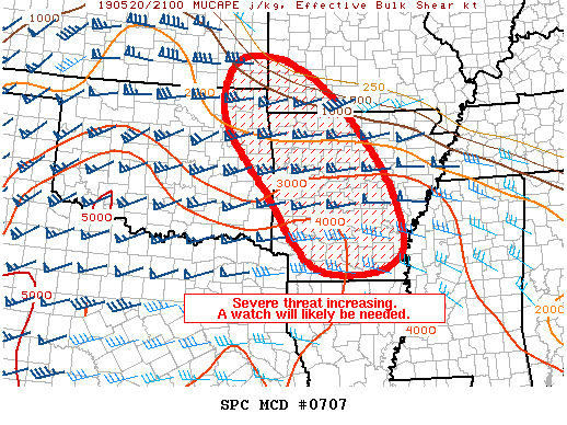
SUMMARY...Thunderstorms are developing near and along the warm
front. Given the strong instability and highly sheared environment,
a tornado watch may be needed for portions of the area.
DISCUSSION...Thunderstorms are developing within a broad warm-air
advection regime across portions of eastern Oklahoma into central
Arkansas. At present these thunderstorms may not be fully rooted in
the boundary layer, but given the increasingly unstable and highly
sheared airmass, and continued northward advancement of a warm
front, at least transient, episodic tapping of the boundary-layer
airmass is likely. The boundary-layer airmass, characterized by
mixed-layer CAPE values at or above 2000 J/kg and deep-layer shear
over 50 knots, will support at least a hail threat for any sustained
thunderstorms. Fort Smith (KSRX) VAD indicated 0-3km storm-relative
helicity values above 500 m2/s2, suggesting that a tornado threat
will be possible with any thunderstorm that can sustain itself in
the boundary layer.
Model guidance is not bullish on evolving or maintaining severe
thunderstorms across the region in the short term, however given the
high quality of the airmass in the vicinity of these thunderstorms,
a lifting warm front across the region, and confidence in additional
strong thunderstorms moving into the area from the west later this
evening, a tornado watch will likely be needed in the next few
hours.
..Marsh/Guyer.. 05/20/2019
...Please see www.spc.noaa.gov for graphic product...
ATTN...WFO...JAN...LZK...SGF...SHV...TSA...ICT...
LAT...LON 34799458 36399569 37619528 37289351 35259166 33459132
33269333 34799458
|


 @NWSSPC