|
| Mesoscale Discussion 2211 |
|
< Previous MD Next MD >
|
|
Mesoscale Discussion 2211
NWS Storm Prediction Center Norman OK
0308 PM CST Mon Dec 16 2019
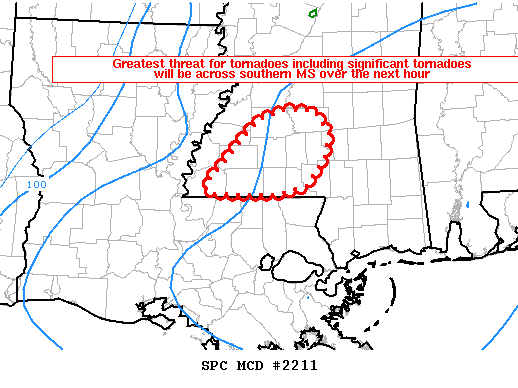
Areas affected...southern Mississippi
Concerning...Tornado Watch 700...
Valid 162108Z - 162215Z
The severe weather threat for Tornado Watch 700 continues.
SUMMARY...Greatest threat for tornadoes will be across southern
Mississippi over the next hour. Significant tornadoes are possible.
DISCUSSION...Multiple supercells are moving northeast across
southwest Mississippi with confirmed tornado reports with two of the
storms. Radar signatures are indicative of possible strong tornadoes
with VROT values of 35-45 knots and tornadic debris signatures were
sampled per KDGX in the last 10-20 minutes. The environment remains
conducive for tornadic supercells with significant tornadoes
possible with 0-1 km SRH of 200+ and STP values around 3.
..Nauslar/Grams.. 12/16/2019
...Please see www.spc.noaa.gov for graphic product...
ATTN...WFO...JAN...LIX...
LAT...LON 31049074 31059129 31149134 31499101 31919062 32029025
32018986 31768965 31478972 31148996 31049039 31049074
|
|
Top/All Mesoscale Discussions/Forecast Products/Home
|
|


 @NWSSPC